 Block
From the record
One of 21 National Register listings published here for Hart County · listed in 2025 · category: Building.
Sources: the National Register database, National Park Service
Listed on the National Register of Historic Places in 2025.
One of 21 National Register listings published here for Hart County · listed in 2025 · category: Building.
Sources: the National Register database, National Park Service
Regional context, not property-specific evidence. The federal wildfire occurrence database lists 29 fires within 5 miles of Bonnieville Elementary School between 1997 and 2020, burning about 138 acres in total. None started naturally. None was recorded as arson. Distance is straight-line from the map coordinates, so a fire counted here may appear on a neighbouring settlement's page as well.
| Reported cause | Fires |
|---|---|
| Missing data/not specified/undetermined | 10 |
| Debris and open burning | 9 |
| Recreation and ceremony | 9 |
| Railroad operations and maintenance | 1 |
The most recent of them, most recent first, with the day each was reported and the service that recorded it.
| Date | Cause | Size | Reported by | Name on the report |
|---|---|---|---|---|
| 17 August 2007 | Recreation and ceremony | 1.0 acres | Kentucky Division of Forestry | not named |
| 11 August 2005 | Missing data/not specified/undetermined | 1.0 acres | Kentucky Division of Forestry | not named |
| 9 April 1997 | Debris and open burning | 2.0 acres | Kentucky Division of Forestry | not named |
| 6 April 2000 | Debris and open burning | 10 acres | Kentucky Division of Forestry | not named |
| 3 April 2003 | Missing data/not specified/undetermined | under an acre | Kentucky Division of Forestry | not named |
| 18 April 2016 | Debris and open burning | 1.0 acres | Kentucky Division of Forestry | CHESTNUT GROVE CEM. |
| 11 April 2005 | Missing data/not specified/undetermined | 4.0 acres | Kentucky Division of Forestry | not named |
| 8 March 2002 | Recreation and ceremony | 1.0 acres | Kentucky Division of Forestry | not named |
Regional context, not property-specific evidence. The federal mineral resources record lists 3 workings within 5 miles of Bonnieville Elementary School: 2 prospects, 1 producer. 1 still produces. What was taken out: Fire Clay (Refractory), Stone, Crushed/Broken. Distance is straight-line from the map coordinates, so a quarry counted here may appear on a neighbouring settlement's page as well.
| Where | Site | Commodity | Status | Recorded |
|---|---|---|---|---|
| Upton Quarry | Stone, Crushed/Broken | Producer | ||
| Bowles Clay Pit | Fire Clay (Refractory) | Prospect | ||
| Childress Clay Pit | Fire Clay (Refractory) | Prospect |
Regional context, not property-specific evidence. The National Weather Service names Bonnieville, the town this property stands in, in 27 storm reports between 1995 and 2026: 15 thunderstorm wind, 9 hail, 2 flash flood, 1 tornado. The reports record 3 deaths and 14 injuries. Each account below is quoted exactly as the forecast office filed it, from the NOAA Storm Events Database, and each date opens the federal record of that event.
| When | Event | Place named | Harm | What the report says |
|---|---|---|---|---|
| February 2025 | Flash Flood | Bonnieville | 2 killed, $10,000 | A woman called 911 after attempting to cross a flooded bridge AT 1900 Campground Road and water began to enter the vehicle. When the Bonnieville Fire Department arrived, they noticed a car partially submerged in high water. They noticed and extradited the driver's daughter from the car, but due to rising water couldn't get extradite the driver until the next day. Both occupants drowned. |
| March 1997 | Tornado (F3) | Bonnieville | 1 killed, 14 hurt, $1,400,000 | no account filed |
| March 2012 | Thunderstorm Wind | Bonnieville | $200,000 | Sporadic wind damage consistent with a microburst was surveyed along the track of a supercell that crossed Hart County. Along Bacon Creek Spur Road, a 30 by 145 greenhouse canopy was lifted. Its supporting poles were bent. A 48 by 70 feet barn had significant roof damage. Quarter sized hail fell at this location. At 5140 State Highway 728, a 32 foot cabin was destroyed. Insulation was thrown 150 yards due east. Just to the east, two tobacco barns were destroyed. A barn canopy was bent and damaged at 11265 Hammondsville Road. The most extensive damage was surveyed along Route 357 South, one mile south of Highway 728. A single-wide mobile home was destroyed, with the roof and most of the exterior siding removed. A nearby barn was also destroyed. |
| May 1995 | Hail | Bonnieville | $25,000 | no account filed |
| April 1995 | Hail | Bonnieville | $1,000 | no account filed |
| April 2026 | Thunderstorm Wind | Bonnieville | - | Trees were down on Frenchman knob Road and Locust Grove Road. |
| March 2020 | Flash Flood | Bonnieville | - | Running water was flowing over the CSX railroad tracks. |
| July 2018 | Thunderstorm Wind | Bonnieville | - | The Hart County Fire Department reported trees down around the intersection of Highway 728 and Campground Road. |
| May 2017 | Thunderstorm Wind | Bonnieville | - | Trained spotters reported numerous trees down across the county. |
| April 2017 | Thunderstorm Wind | Bonnieville | - | NWS Employee reported two large oak trees down in the area. |
| July 2016 | Thunderstorm Wind | Bonnieville | - | Trained spotters measured a 56 knot gust which brought down numerous large trees in Horse Cave and Munfordville. |
| June 2015 | Thunderstorm Wind | Bonnieville | - | According to a public report, several large trees were down due to severe thunderstorm winds. |
| August 2014 | Thunderstorm Wind | Bonnieville | - | A NWS Employee reported that two hardwood trees fell near Reynolds Lane east of Bonnieville. |
| July 2014 | Thunderstorm Wind | Bonnieville | - | A thunderstorm collapsed and the resulting bowing segment knocked down several trees in the Bonnieville area. |
| June 2007 | Hail | Bonnieville | - | The spotter also reported a 55 mph wind gust. |
| May 2004 | Thunderstorm Wind | Bonnieville | - | Several trees were downed. |
| July 1999 | Thunderstorm Wind | Bonnieville | - | Trees down |
| April 1998 | Hail | Bonnieville | - | Quarter size hail reported at Bonnieville. |
| April 2018 | Hail | Bonnieville | - | no account filed |
| April 2017 | Thunderstorm Wind | Bonnieville | - | no account filed |
| May 2016 | Hail | Bonnieville | - | no account filed |
| April 2006 | Hail | Bonnieville | - | no account filed |
| March 2001 | Hail | Bonnieville | - | no account filed |
| June 2001 | Thunderstorm Wind | Bonnieville | - | no account filed |
| June 2001 | Hail | Bonnieville | - | no account filed |
| June 1998 | Thunderstorm Wind | Bonnieville | - | no account filed |
| June 1998 | Thunderstorm Wind | Bonnieville | - | no account filed |
No historic map-sheet match is published for this property yet. That does not mean no map exists. This record needs a coordinate-quality review before it can be joined to a sheet boundary. Browse the county's mapped places while that work is pending.
Other National Register properties close enough to walk or drive between, ordered by distance from this one. Both positions come from the same geocoding pass that matched these properties to their map sheets.
| Photograph | Property | Distance | Listed |
|---|---|---|---|
 | Hart County Deposit Bank and Trust Company Building | 7.5 miles | 1980 |
| Dr. Lewis Barrett House | 7.6 miles | 1980 | |
 | Hart County Courthouse | 7.6 miles | 1980 |
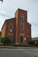 | Munfordville Presbyterian Church and Green River Lodge No.88 | 7.6 miles | 1980 |
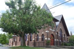 | Munfordville Baptist Church | 7.6 miles | 1980 |
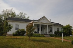 | Munfordville School | 7.6 miles | 1984 |
| National Archives record | The nomination case file for reference 100011664 in Record Group 79. |
| Hart County | All 21 listed properties in this county. |