 Block
From the record
One of 11 National Register listings published here for Ohio County · listed in 1973 · category: Building.
Sources: the case file at the National Archives · the National Register database, National Park Service
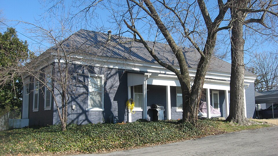
Listed on the National Register of Historic Places in 1973.
One of 11 National Register listings published here for Ohio County · listed in 1973 · category: Building.
Sources: the case file at the National Archives · the National Register database, National Park Service
Regional context, not property-specific evidence. The federal wildfire occurrence database lists 24 fires within 5 miles of Hartford Seminary between 1998 and 2012, burning about 133 acres in total. 1 started naturally. None was recorded as arson. Distance is straight-line from the map coordinates, so a fire counted here may appear on a neighbouring settlement's page as well.
| Reported cause | Fires |
|---|---|
| Missing data/not specified/undetermined | 13 |
| Recreation and ceremony | 5 |
| Debris and open burning | 4 |
| Natural | 1 |
| Railroad operations and maintenance | 1 |
The most recent of them, most recent first, with the day each was reported and the service that recorded it.
| Date | Cause | Size | Reported by | Name on the report |
|---|---|---|---|---|
| 4 September 2008 | Missing data/not specified/undetermined | 1.0 acres | Kentucky Division of Forestry | not named |
| 13 September 2008 | Debris and open burning | 1.0 acres | Kentucky Division of Forestry | not named |
| 12 September 2002 | Recreation and ceremony | 1.0 acres | Kentucky Division of Forestry | not named |
| 5 July 2012 | Natural | 14 acres | Kentucky Division of Forestry | BEAGLE CLU |
| 6 April 1998 | Debris and open burning | 11 acres | Kentucky Division of Forestry | not named |
| 5 April 2005 | Missing data/not specified/undetermined | 1.0 acres | Kentucky Division of Forestry | not named |
| 13 April 2010 | Recreation and ceremony | 2.0 acres | Kentucky Division of Forestry | not named |
| 11 April 2003 | Missing data/not specified/undetermined | under an acre | Kentucky Division of Forestry | not named |
Regional context, not property-specific evidence. The National Weather Service names Hartford, the town this property stands in, in 56 storm reports between 1995 and 2026: 32 thunderstorm wind, 14 hail, 6 flash flood, 2 flood. No death or injury is recorded in these reports. Each account below is quoted exactly as the forecast office filed it, from the NOAA Storm Events Database, and each date opens the federal record of that event.
| When | Event | Place named | Harm | What the report says |
|---|---|---|---|---|
| May 2016 | Tornado (EF2) | Hartford | $150,000 | A tornado briefly touched down on Spinks Drive just off of Highway 69, initially causing EF-0 damage. The tornado was only on the ground for approximately 200 yards with a path width about 30-40 yards. A basement crawlspace door was blown out along with siding and roof damage at 125 Spinks Dr. There was evidence of isolated straight-line winds with some maple trees on Hamlin Chapel Dr. The tornado touched down for a second time at 41 El Retiro Ln where the path width increased to 50 yards and the winds speed increased to 90-95 mph. Numerous large hardwood trees were snapped and twisted. An outbuilding, previously used to make brooms, next to the house had significant damage when a large tree fell on top of it. The residents observed pea size hail. ||The tornado increased in size at 532 Stoneridge Ln. A custom-built home had exterior wall damage in the master bedroom with adjacent bathroom. Their insulation blew out in all directions in the house and the back porch resembled a snow globe. Numerous trees were down along the property as well as a grain silo. The family survived the tornado by sheltering in a 3-foot crawlspace and when they came out, there was quarter-sized hail on the ground. Winds in this area were 110 mph with a path width about 125 yards.||The tornado continued to move east northeast along the countryside uprooting twisting and damaging numerous hardwood trees. The tornado significantly increased in width to approximately 300 yards and did a lot of damage along Halls Creek Rd. At 1130 Halls Creed Road 2-inch hail occurred before the EF-2 tornado, with winds of 111 mph, did significant damage to the property, which included a 30x50 large barn sliding the wall 12 feet.||Along Walnut Rd, the tornado caused damage to several barns and numerous softwood trees and hardwood trees. Metal sheeting from barns was thrown in excess of 400 yards downwind.||At the intersection of Highway 1164 and 1544 at the Cedar Grove Church there was roof damage to the church and many trees were twisted and uprooted. The last visible damage was along Highway 1544 just east of 1164 with some trees uprooted and twisted. About 30 feet from the tree there was an outbuilding that had half its roof blown off and the roof remnants were found about 50 yards away. The tornado lifted approximately 400 yards from Highway 1544 near the intersection of 1164. |
| February 2008 | Thunderstorm Wind | Hartford | $30,000 | Thunderstorm winds caused severe roof damage to a house. |
| June 2019 | Thunderstorm Wind | Hartford | $20,000 | Trees and power lines were down in central Ohio County. |
| October 2017 | Thunderstorm Wind | Hartford | $20,000 | Officials reported 5 power poles fell along north Main Street. |
| October 2007 | Thunderstorm Wind | Hartford | $20,000 | The roof was blown off a building in Hartford. |
| June 1998 | Thunderstorm Wind | Hartford | $20,000 | no account filed |
| May 1995 | Thunderstorm Wind | Hartford | $10,000 | Several trees were blown down in Hartford. |
| September 1996 | Thunderstorm Wind | Hartford | $5,000 | no account filed |
| April 2026 | Thunderstorm Wind | Hartford | - | There were power lines and trees down along Crab Tree Alley. |
| April 2026 | Thunderstorm Wind | Hartford | - | There were power lines and trees down near Walnut and Clay Streets. |
| April 2026 | Tornado (EF1) | Hartford | - | The EF-1 tornado touched down briefly near the Rough River. It intensified as it crossed Highway 69, doing significant tree damage and some minor structural damage to homes along Highway 69. The tornado continued to the southeast where it ripped much of the roof of a home along Mill Run Lane, before lifting just before the Hartford, KY Airport. |
| April 2025 | Flash Flood | Hartford | - | Highway 69 was closed between Main Street and Interstate 165 due to high water. |
| May 2024 | Thunderstorm Wind | Hartford | - | Trees and power lines were downed across Ohio County, including in and around Hartford. |
| April 2023 | Thunderstorm Wind | Hartford | - | A 60 mph wind gust was measured at the Ohio County Mesonet site. |
| February 2019 | Flash Flood | Hartford | - | Roads were reported to be flooded. |
| May 2019 | Hail | Hartford | - | Broadcast media reported that 1.75 inch hail fell along the Natcher Parkway. |
| February 2018 | Flood | Hartford | - | Multiple roads closed due to high water and flooding. |
| April 2016 | Flood | Hartford | - | An Ohio County official reported water over roadways across parts of the county. |
| April 2016 | Thunderstorm Wind | Hartford | - | Trees and power lines were reported down in the area. |
| April 2016 | Thunderstorm Wind | Hartford | - | A Ohio County official reported trees down in the area. |
| June 2016 | Thunderstorm Wind | Hartford | - | Trees were reported down in the area. |
| May 2016 | Thunderstorm Wind | Hartford | - | Trained spotters reported trees down in the area. |
| August 2016 | Thunderstorm Wind | Hartford | - | The local department of highways reported numerous trees down in the area due to severe thunderstorm winds. |
| July 2016 | Flash Flood | Hartford | - | The Ohio County emergency manager reported that most city streets were covered by high water due to excessive rainfall. |
| June 2015 | Thunderstorm Wind | Hartford | - | A picture on Twitter relayed to the NWS by the public showed a large tree fell down due to severe thunderstorm winds. |
| July 2015 | Flash Flood | Hartford | - | An Ohio County law enforcement official reported that Highway 69 north of town was flooded due to excessive rainfall and high water. |
| July 2015 | Thunderstorm Wind | Hartford | - | The Ohio County dispatch center reported downed trees blocking the roadway. |
| March 2012 | Hail | Hartford | - | A supercell brought 1 inch hail to Hartford along with extensive wind damage and a report of a funnel cloud. |
| July 2012 | Thunderstorm Wind | Hartford | - | Two large trees fell across power lines in Hartford. |
| April 2011 | Flash Flood | Hartford | - | Roads were flooded and a few were impassable west of Beaver Dam. |
| May 2010 | Hail | Hartford | - | Local law enforcement from the towns of Hartford, Beaver Dam, and Rockport in Ohio County reported quarter size hail. |
| June 2009 | Thunderstorm Wind | Hartford | - | Trees were down across HWY 136. |
| April 2006 | Thunderstorm Wind | Hartford | - | Trees were downed. |
| May 2004 | Thunderstorm Wind | Hartford | - | Trees and power lines were downed. |
| July 2004 | Thunderstorm Wind | Hartford | - | Trees were downed. A spotter estimated wind speeds of up to 70 mph. |
| July 2004 | Thunderstorm Wind | Hartford | - | A spotter estimated a 60 mph gust. |
| September 2003 | Flash Flood | Hartford | - | Mount Vernon Road, Lake Lane, and Round Hill Road were all closed and barricaded due to high water. |
| September 2002 | Thunderstorm Wind | Hartford | - | Power lines were downed. |
| September 2001 | Thunderstorm Wind | Hartford | - | A large tree was downed by thunderstorm winds. |
| January 1999 | Thunderstorm Wind | Hartford | - | Large trees down across county |
| May 2017 | Hail | Hartford | - | no account filed |
| May 2016 | Hail | Hartford | - | no account filed |
| May 2016 | Hail | Hartford | - | no account filed |
| April 2011 | Hail | Hartford | - | no account filed |
| April 2006 | Hail | Hartford | - | no account filed |
| April 2006 | Hail | Hartford | - | no account filed |
| April 2006 | Hail | Hartford | - | no account filed |
| April 2006 | Hail | Hartford | - | no account filed |
| June 2006 | Thunderstorm Wind | Hartford | - | no account filed |
| June 2006 | Thunderstorm Wind | Hartford | - | no account filed |
| January 2002 | Thunderstorm Wind | Hartford | - | no account filed |
| June 2001 | Thunderstorm Wind | Hartford | - | no account filed |
| May 2000 | Thunderstorm Wind | Hartford | - | no account filed |
| May 2000 | Hail | Hartford | - | no account filed |
| June 1998 | Hail | Hartford | - | no account filed |
| April 1998 | Hail | Hartford | - | no account filed |
2 papers published in this town, digitised by the Library of Congress and free to read: 4,003 issues, 23,558 pages. Every page is searchable, so a name or a street can be looked for directly in what the town printed about itself at the time.
| Newspaper | Published |
|---|---|
| The Hartford Republican | 18?? to 1926 |
| The Hartford Herald | 1875 to 1926 |
No historic map-sheet match is published for this property yet. That does not mean no map exists. This record needs a coordinate-quality review before it can be joined to a sheet boundary. Browse the county's mapped places while that work is pending.
Other National Register properties close enough to walk or drive between, ordered by distance from this one. Both positions come from the same geocoding pass that matched these properties to their map sheets.
| Photograph | Property | Distance | Listed |
|---|---|---|---|
 | Old Town Historic District | under 500 feet | 1988 |
 | Downtown Hartford Historic District | 0.2 miles | 1988 |
 | Pendleton House | 0.2 miles | 1973 |
| Downtown Hartford Historic District | 0.2 miles | 1988 |
 | Samuel E. Hill House | 0.5 miles | 1980 |
 | Bill Monroe Farm | 7.9 miles | 2003 |
| National Archives record | The nomination case file for reference 73000826 in Record Group 79. |
| Ohio County | All 11 listed properties in this county. |