
BlockBefore
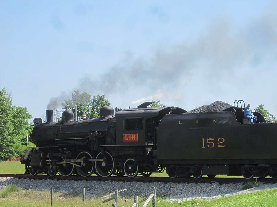
Photograph of Louisville and Nashville Railroad 152
Photograph by Grantadria152, CC BY-SA 3.0. Via Wikimedia Commons.

L & N Steam Locomotive No. 152

Listed on the National Register of Historic Places in 1974.

From the record

“Louisville and Nashville 152 is a preserved K-2A class 4-6-2 "Pacific" type steam locomotive, built in 1905 by the Rogers Locomotive Works (RLW) for the Louisville and Nashville Railroad (L&N). It is listed on the National Register of Historic Places, and owned by the Kentucky Railway Museum (KRM) at New Haven, Kentucky in southernmost Nelson County, Kentucky.”

Wikipedia article Louisville and Nashville 152, CC BY-SA 4.0.

One of 44 National Register listings published here for Nelson County · listed in 1974 · category: Structure.

Sources: the Wikipedia article · the case file at the National Archives · the National Register database, National Park Service

The listing

  • What is counted as historic. The nomination lists 1 structure as contributing to the listing.
  • Address. Jct. of Depot and First Sts., New Haven, 40206
  • When was it listed? December 1974
  • Category. structure
  • National Register reference number. 74000883 - the number the National Park Service assigned this property when it was listed, and the key its nomination file is catalogued under at the National Archives.

Storms near this property

12 since 1995

Regional context, not property-specific evidence. The National Weather Service names New Haven, the town this property stands in, in 12 storm reports between 1995 and 2024: 5 thunderstorm wind, 4 hail, 1 lightning, 1 flash flood. The reports record 2 deaths. Each account below is quoted exactly as the forecast office filed it, from the NOAA Storm Events Database, and each date opens the federal record of that event.

WhenEvent Place namedHarm What the report says
August 2000LightningNew Haven2 killed, $25,000During the early morning hours of Thursday August 24, 2000, a complex of thunderstorms across South Central Indiana moved south into North Central Kentucky. The area of thunderstorms produced very heavy rain, locally strong winds and frequent lightning. A lightning strike apparently started a fire in a mobile home around 2 AM EST, possibly after striking near a propane tank. Two females, ages 7 and 9, were killed in the mobile home, apparently due to smoke inhalation.
May 1995Thunderstorm WindNew Haven$50,000Three roofs damaged by thunderstorm winds.
June 2024Thunderstorm WindNew Haven-Trees and power lines were down near Howardstown Road and Walter Hall Road.
July 2023Thunderstorm WindNew Haven-Multiple trees were blown down by strong winds near New Haven. About 600 customers were without power in the area.
February 2008FloodNew Haven-The Rolling Fork River at Boston crested at 35.2 feet around 930 AM EST on February 8. Flood stage at Boston is 35 feet. Minor flooding occurs at this level, with agricultural bottom land covered.
January 2006HailNew Haven-Penny size hail covered the ground.
February 2003Flash FloodNew Haven-Some creeks and streams were out of their banks.
May 2002HailNew Haven-no account filed
November 2000Thunderstorm WindNew Haven-no account filed
April 1997HailNew Haven-no account filed
April 1997Thunderstorm WindNew Haven-no account filed

Every storm recorded in Nelson County

Map coverage status

No historic map-sheet match is published for this property yet. That does not mean no map exists. This record needs a coordinate-quality review before it can be joined to a sheet boundary. Browse the county's mapped places while that work is pending.

Sources for this property

National Archives recordThe nomination case file for reference 74000883 in Record Group 79.
Wikipedia articleCommunity-written account of this property, licensed CC BY-SA.
Nelson CountyAll 44 listed properties in this county.

Provenance

  • Listing record. National Park Service National Register of Historic Places, listed-properties dataset, current to 2026-05-22.
  • Map join. Address geocoded through the United States Census geocoder, then tested against the published boundary of every sheet in the USGS Historical Topographic Map Collection.
  • How this page is made. Listing fields come from federal records; map-sheet coverage is a labelled coordinate-to-boundary calculation, not a source-field claim.
  • Storms. NOAA National Centers for Environmental Information, Storm Events Database https://www.ncei.noaa.gov/stormevents/ A work of the United States government, no copyright under 17 U.S.C. 105. Narratives are quoted verbatim from the National Weather Service report and are not edited or summarised.