BlockBefore
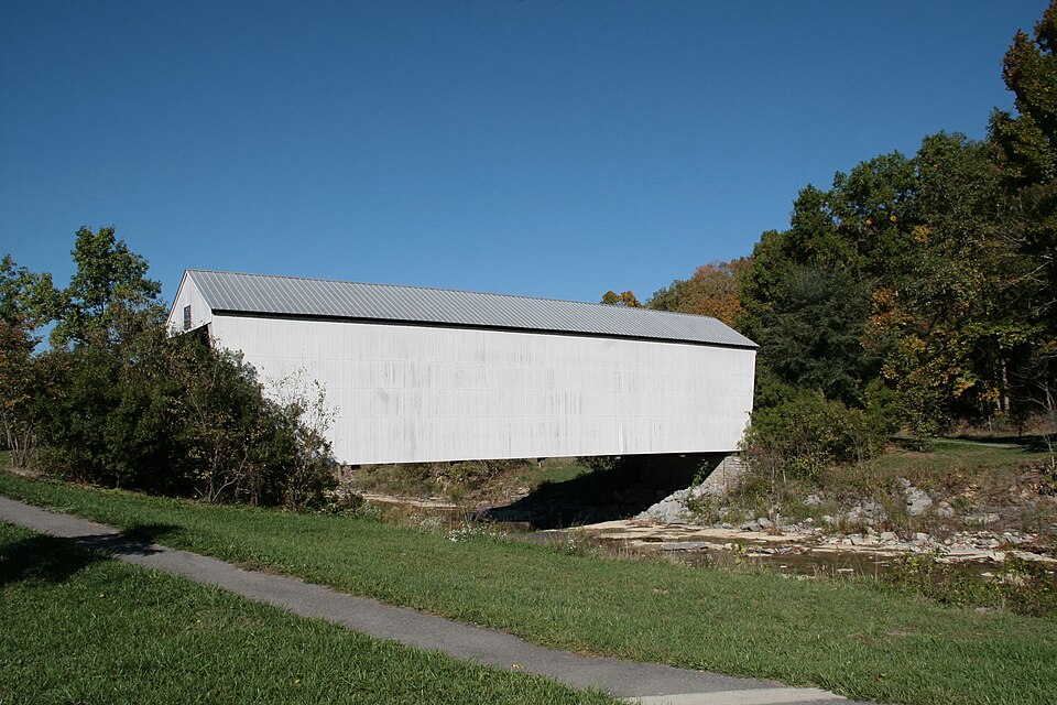
Photograph of Walcott Covered Bridge
Photograph by Photo by Greg Hume ( Greg5030 ), CC BY-SA 3.0. Via Wikimedia Commons.

Walcott Covered Bridge

Built in 1824. Listed on the National Register of Historic Places in 1975.

From the record

“The Walcott Covered Bridge is situated at a point where Kentucky Highway 1159 used to cross Locust Creek in Bracken County, Kentucky. A concrete bridge was constructed in 1954, about 200 feet northwest of the covered bridge and the older structure was then bypassed by highway traffic.”

Wikipedia article Walcott Covered Bridge, CC BY-SA 4.0.

One of 23 National Register listings published here for Bracken County · listed in 1975 · category: Structure · built in 1824.

Sources: the Wikipedia article · the case file at the National Archives · the National Register database, National Park Service
The listing

  • What is counted as historic. The nomination lists 1 structure as contributing to the listing.
  • Address. 3.5 mi. N of Brooksville on SR 1159 over Locust Creek, Brooksville, 41004
  • When was it listed? June 1975
  • Category. structure
  • Census division. Augusta
  • When was it built? 1824
  • National Register reference number. 75000738 - the number the National Park Service assigned this property when it was listed, and the key its nomination file is catalogued under at the National Archives.

Fires near this property

2 since 2002

Regional context, not property-specific evidence. The federal wildfire occurrence database lists 2 fires within 5 miles of Walcott Covered Bridge between 2002 and 2004, burning about 21 acres in total. None started naturally. None was recorded as arson. Distance is straight-line from the map coordinates, so a fire counted here may appear on a neighbouring settlement's page as well.

Reported cause Fires
Recreation and ceremony1
Missing data/not specified/undetermined1

The most recent of them, most recent first, with the day each was reported and the service that recorded it.

DateCause SizeReported by Name on the report
29 February 2004Missing data/not specified/undetermined10 acresKentucky Division of Forestrynot named
14 February 2002Recreation and ceremony11 acresKentucky Division of Forestrynot named

Every fire recorded in Bracken County

Storms near this property

29 since 1994

Regional context, not property-specific evidence. The National Weather Service names Brooksville, the town this property stands in, in 29 storm reports between 1994 and 2024: 22 thunderstorm wind, 4 hail, 2 flood, 1 tornado. The reports record 2 deaths and 3 injuries. Each account below is quoted exactly as the forecast office filed it, from the NOAA Storm Events Database, and each date opens the federal record of that event.

WhenEvent Place namedHarm What the report says
July 2001Thunderstorm WindBrooksville2 killed, 3 hurt, $100,000Thunderstorm winds blew over a mobile home killing 2 and injuring 3 people. Another mobile home was damaged and trees were knocked down.
April 2024Tornado (EF0)Brooksville$750,000The tornado began along Brooksville-Powersville Road west of Hamilton Road. Tree damage was observed in the area along with some minor damage to a home east of Hamilton Road. Several barns were heavily damaged or destroyed in the area. Additional observed damage was located on Michaels Lane and McNamara Lane where several barns were damaged. The tornado continued eastward, crossing Brooksville-Germantown Road, causing damage to more barns, outbuildings, and trees. Based on radar data and observed damage provided by the public on social media, it is believe the tornado dissipated north of Brooksville-Germantown Road west of Locust Creek.
June 2020Thunderstorm WindBrooksville$30,000Significant property damage was reported on Delaney Road. This included an outbuilding destroyed, a porch damaged, loss of roofing shingles and trees and large limbs knocked down.
August 2007Thunderstorm WindBrooksville$15,000A mobile home was moved onto Hamilton Road.
August 2007Thunderstorm WindBrooksville$15,000A barn was blown over along State Route 22 in the eastern part of the county.
March 2011Thunderstorm WindBrooksville$10,000Two utility poles were snapped off and a tree fell on electric lines due to damaging thunderstorm winds.
April 2017Thunderstorm WindBrooksville$8,000Multiple trees were knocked down in the Brookville area, including one in a house on Woodward Ave.
February 2009Thunderstorm WindBrooksville$8,000A car port was blown down at a residence.
November 2010Thunderstorm WindBrooksville$6,000A carport was destroyed due to damaging thunderstorm winds.
August 2007Thunderstorm WindBrooksville$6,000Trees and power lines were downed across the county.
June 2022Thunderstorm WindBrooksville$5,000Several trees were downed in the Brooksville area.
April 2017Thunderstorm WindBrooksville$5,000Several trees were knocked down throughout the county. A barn was damaged near the intersection of Highway 18 and Hamilton Road.
September 2000Thunderstorm WindBrooksville$5,000Trees downed across several roads.
July 2000Thunderstorm WindBrooksville$5,000Numerous trees knocked down.
June 2020Thunderstorm WindBrooksville$4,000Several trees were knocked down on Brooksville-Germantown Road.
April 2020Thunderstorm WindBrooksville$3,000A tobacco barn was destroyed.
May 2018Thunderstorm WindBrooksville$3,000Several trees were downed.
July 2007Thunderstorm WindBrooksville$3,000Trees were knocked down.
August 2004Thunderstorm WindBrooksville$3,000Several power poles and a tree were downed.
May 2011FloodBrooksville$2,000Roads were closed due to high water.
July 2003Thunderstorm WindBrooksville$2,000Large limbs were knocked down.
April 2023Thunderstorm WindBrooksville$1,000A tree was downed onto a road.
April 2014FloodBrooksville-Water several feet deep from an overflowing creek was reported over Jett Road due to heavy rain. A few other roads in the county also were reported to have high water over them.
July 1994HailBrooksville-Tobacco crops flattened East of Augusta. Numerous reports of trees and power lines downed.
April 2023Thunderstorm WindBrooksville-no account filed
May 2022HailBrooksville-no account filed
June 2009HailBrooksville-no account filed
January 2005Thunderstorm WindBrooksville-no account filed
May 2003HailBrooksville-no account filed

Every storm recorded in Bracken County

Map coverage status

No historic map-sheet match is published for this property yet. That does not mean no map exists. This record needs a coordinate-quality review before it can be joined to a sheet boundary. Browse the county's mapped places while that work is pending.

Listed places nearby

6 within 8 miles

Other National Register properties close enough to walk or drive between, ordered by distance from this one. Both positions come from the same geocoding pass that matched these properties to their map sheets.

Photograph PropertyDistance Listed
Mordecai Chalfant House2.4 miles1987
Rock Spring Warehouse2.5 miles1987
Bradford School House4.0 miles2003
Bracken County Infirmary4.8 miles1979
Confederate Monument in Augusta5.4 miles1997
Alfonso McKibben House5.6 miles1984

Sources for this property

National Archives recordThe nomination case file for reference 75000738 in Record Group 79.
Wikipedia articleCommunity-written account of this property, licensed CC BY-SA.
Bracken CountyAll 23 listed properties in this county.

Provenance

  • Listing record. National Park Service National Register of Historic Places, listed-properties dataset, current to 2026-05-22.
  • Map join. Address geocoded through the United States Census geocoder, then tested against the published boundary of every sheet in the USGS Historical Topographic Map Collection.
  • How this page is made. Listing fields come from federal records; map-sheet coverage is a labelled coordinate-to-boundary calculation, not a source-field claim.
  • Wildfire. Short, Karen C. 2022. Spatial wildfire occurrence data for the United States, 1992-2020 [FPA_FOD_20221014]. 6th Edition. Fort Collins, CO: Forest Service Research Data Archive. https://doi.org/10.2737/RDS-2013-0009.6 Collected with United States Government funding and usable without additional permissions or fees.
  • Storms. NOAA National Centers for Environmental Information, Storm Events Database https://www.ncei.noaa.gov/stormevents/ A work of the United States government, no copyright under 17 U.S.C. 105. Narratives are quoted verbatim from the National Weather Service report and are not edited or summarised.