BlockBefore
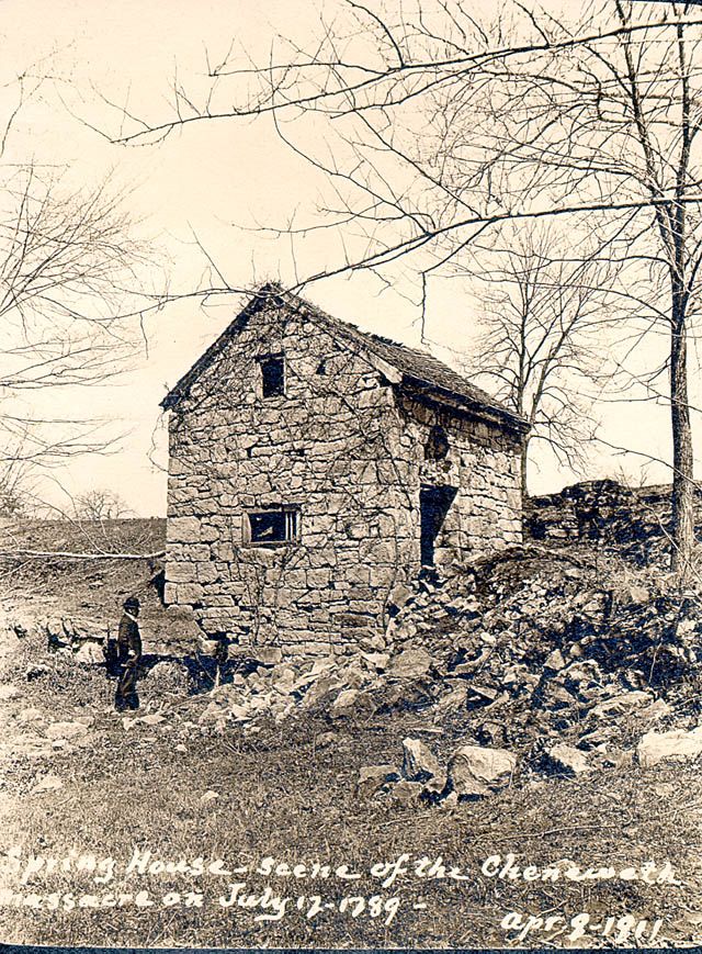
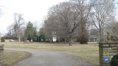
Photograph of Chenoweth Fort-Springhouse
Photograph by Unknown, Public domain. Via Wikimedia Commons.

Chenoweth Fort-Springhouse

Listed on the National Register of Historic Places in 1975.

From the record

“The Chenoweth Fort-Springhouse is a historic stone structure near Avoca Road near Middletown, Kentucky. Built about 1786, it is believed to be the oldest standing structure in Louisville, Kentucky, and was the site of the Chenoweth Massacre, a 1789 Native American raid during the Northwest Indian War that was the last raid in Jefferson county.”

Wikipedia article Chenoweth Fort-Springhouse, CC BY-SA 4.0.

One of 526 National Register listings published here for Jefferson County · listed in 1975 · category: Building.

Sources: the Wikipedia article · the case file at the National Archives · the National Register database, National Park Service
The listing

  • What is counted as historic. The nomination lists 1 building as contributing to the listing.
  • Address. Avoca Rd., Middletown, 40223
  • When was it listed? July 1975
  • Category. building
  • Census division. East Jefferson
  • National Register reference number. 75000779 - the number the National Park Service assigned this property when it was listed, and the key its nomination file is catalogued under at the National Archives.

Mines and quarries near this property

3 within 5 miles

Regional context, not property-specific evidence. The federal mineral resources record lists 3 workings within 5 miles of Chenoweth Fort-Springhouse: 2 producers, 1 unknown. 2 still produce. What was taken out: Stone, Crushed/Broken. Distance is straight-line from the map coordinates, so a quarry counted here may appear on a neighbouring settlement's page as well.

Where SiteCommodity StatusRecorded
Avoca QuarryStone, Crushed/BrokenProducer
Crestwood Mine UndergroundStone, Crushed/BrokenProducer
Crestwood QuarryStone, Crushed/BrokenUnknown

Every working recorded in Jefferson County

Storms near this property

12 since 1996

Regional context, not property-specific evidence. The National Weather Service names Middletown, the town this property stands in, in 12 storm reports between 1996 and 2024: 5 thunderstorm wind, 3 flash flood, 2 lightning, 2 hail. No death or injury is recorded in these reports. Each account below is quoted exactly as the forecast office filed it, from the NOAA Storm Events Database, and each date opens the federal record of that event.

WhenEvent Place namedHarm What the report says
May 1996Thunderstorm WindMiddletown$200,000no account filed
May 2005LightningMiddletown$10,000A lightning strike caused a house fire on Waters Edge Drive.
July 1996LightningMiddletown$10,000no account filed
August 1999Thunderstorm WindMiddletown$2,000Windows were cracked at Eastern High School
May 2024Thunderstorm WindMiddletown-Large trees were uprooted in a yard in Middletown.
July 2023Flash FloodMiddletown-Heavy rain caused Evergreen Road to become impassable between Shelbyville Road and Ridge Road.
February 2018Flash FloodMiddletown-Amateur radio operators reported numerous reports of flooded roadways across much of Louisville metro including water rescues in the Anchorage area. Manhole covers reported off in the downtown area.
June 2015Thunderstorm WindMiddletown-The public relayed a report of a large Hickory tree down along Harrods Creek Road.
May 2004Flash FloodMiddletown-Heavy rains caused creeks in parts of eastern Jefferson County to run out of their banks.
July 2004HailMiddletown-no account filed
April 2001HailMiddletown-no account filed
July 1996Thunderstorm WindMiddletown-no account filed

Every storm recorded in Jefferson County

Map coverage status

No historic map-sheet match is published for this property yet. That does not mean no map exists. This record needs a coordinate-quality review before it can be joined to a sheet boundary. Browse the county's mapped places while that work is pending.

Listed places nearby

6 within 8 miles

Other National Register properties close enough to walk or drive between, ordered by distance from this one. Both positions come from the same geocoding pass that matched these properties to their map sheets.

Photograph PropertyDistance Listed
Simrall-Warfield House1.3 miles1980
John Marshall Sr. House1.4 miles1980
Abraham L. Williams L & N Guest House1.4 miles1980
Bonavita-Weller House1.4 miles1983
Otto F. Eitel House1.4 miles1998
James Courteney House1.4 miles1980

Sources for this property

National Archives recordThe nomination case file for reference 75000779 in Record Group 79.
Wikipedia articleCommunity-written account of this property, licensed CC BY-SA.
Jefferson CountyAll 526 listed properties in this county.

Provenance

  • Listing record. National Park Service National Register of Historic Places, listed-properties dataset, current to 2026-05-22.
  • Map join. Address geocoded through the United States Census geocoder, then tested against the published boundary of every sheet in the USGS Historical Topographic Map Collection.
  • How this page is made. Listing fields come from federal records; map-sheet coverage is a labelled coordinate-to-boundary calculation, not a source-field claim.
  • Mines and quarries. USGS Mineral Resources Data System (MRDS) https://mrdata.usgs.gov/mrds/ A work of the United States government, no copyright under 17 U.S.C. 105.
  • Storms. NOAA National Centers for Environmental Information, Storm Events Database https://www.ncei.noaa.gov/stormevents/ A work of the United States government, no copyright under 17 U.S.C. 105. Narratives are quoted verbatim from the National Weather Service report and are not edited or summarised.