
BlockBefore
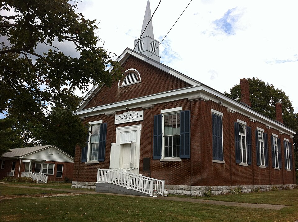
Photograph of New Providence Presbyterian Church
Photograph by Flynnke, CC BY-SA 3.0. Via Wikimedia Commons.

New Providence Presbyterian Church

Listed on the National Register of Historic Places in 1975.

From the record

“The New Providence Presbyterian Church near Salvisa, Kentucky is a historic Greek Revival-style church built between 1862 and 1865. It was added to the National Register of Historic Places in 1975.”

Wikipedia article New Providence Presbyterian Church (Salvisa, Kentucky), CC BY-SA 4.0.

One of 70 National Register listings published here for Mercer County · listed in 1975 · category: Building.

Sources: the Wikipedia article · the case file at the National Archives · the National Register database, National Park Service · the Wikipedia article

The listing

  • What is counted as historic. The nomination lists 1 building as contributing to the listing.
  • Address. 3 mi. S of Salvisa on U.S. 127, Salvisa, 40372
  • When was it listed? October 1975
  • Category. building
  • Census division. Salvisa-McAfee
  • Architectural style. Greek Revival architecture
  • National Register reference number. 75000806 - the number the National Park Service assigned this property when it was listed, and the key its nomination file is catalogued under at the National Archives.

Storms near this property

18 since 1995

Regional context, not property-specific evidence. The National Weather Service names Salvisa, the town this property stands in, in 18 storm reports between 1995 and 2024: 9 thunderstorm wind, 4 tornado, 3 lightning, 1 hail. The reports record 8 injuries. Each account below is quoted exactly as the forecast office filed it, from the NOAA Storm Events Database, and each date opens the federal record of that event.

WhenEvent Place namedHarm What the report says
May 1995Tornado (F2)Salvisa8 hurt, $5,000,000no account filed
May 2010FloodSalvisa$100,000Six to seven inches of rain fell over Mercer county from May 1-2. This caused major flooding on the Kentucky River that lasted many days before receding.
July 2006LightningSalvisa$50,000A barn was struck by lightning and burned.
June 1998LightningSalvisa$50,000Lightning struck an auto body shop causing major damage.
May 2016Thunderstorm WindSalvisa$10,000A broadcast meteorologist relayed a report of a barn down in Salvisa due to severe thunderstorm winds.
July 2012Thunderstorm WindSalvisa$5,000The public reported that a 175 foot steel tower used for amateur radio antennas was toppled by high winds on Bondville Road.
May 1998Tornado (F0)Salvisa$5,000DES reported a weak F0 tornado cut a narrow path of 2 miles along Gilbert's Creek damaging 2 storage buildings but 125 trees were uprooted. Resulting debris blocked off most of Oregon Road from US 127 to the Kentucky River where the tornado lifted.
June 2007LightningSalvisa$3,000Lightning destroyed a small outbuilding.
April 2024Thunderstorm WindSalvisa-The National Weather Service in Louisville confirmed straight-line winds in Salvisa. There was a bunch of cedar and maple tree damage off of Old Louisville Road on the north side of Salvisa. Three homes experienced shingle, gutter and roof damage. ||A barndominium had the most significant damage with a large section of the roof thrown several hundred yards to the east southeast. Wind speeds were estimated between 75 and 80 mph, with a width of the damage of up to a half mile sporadically.
July 2021Thunderstorm WindSalvisa-A tree fell over a road near Salvisa.
June 2021Thunderstorm WindSalvisa-A tree fell down.
May 2015Thunderstorm WindSalvisa-A law enforcement official reported trees down on Old Louisville and Kirkwood Rd.
April 2010Thunderstorm WindSalvisa-Damage to several structures including a tobacco barn and a fence row near Salvisa.
August 1997HailSalvisa-Dime size hail reported.
May 1995TornadoSalvisa-Citizen reports tornado touchdown.
August 2003Thunderstorm WindSalvisa-no account filed
September 2000Thunderstorm WindSalvisa-no account filed
May 1995Tornado (F2)Salvisa-no account filed

Every storm recorded in Mercer County

Map coverage status

No historic map-sheet match is published for this property yet. That does not mean no map exists. This record needs a coordinate-quality review before it can be joined to a sheet boundary. Browse the county's mapped places while that work is pending.

Listed places nearby

6 within 8 miles

Other National Register properties close enough to walk or drive between, ordered by distance from this one. Both positions come from the same geocoding pass that matched these properties to their map sheets.

Photograph PropertyDistance Listed
Ambrose Burton House1.2 miles1983
James McAfee House1.2 miles1983
Peter Dunn House1.4 miles1989
Millwood1.7 miles1976
George McAfee House1.9 miles1983
McAfee Farm Historic District1.9 miles1989

Sources for this property

National Archives recordThe nomination case file for reference 75000806 in Record Group 79.
Wikipedia articleCommunity-written account of this property, licensed CC BY-SA.
Mercer CountyAll 70 listed properties in this county.

Provenance

  • Listing record. National Park Service National Register of Historic Places, listed-properties dataset, current to 2026-05-22.
  • Map join. Address geocoded through the United States Census geocoder, then tested against the published boundary of every sheet in the USGS Historical Topographic Map Collection.
  • How this page is made. Listing fields come from federal records; map-sheet coverage is a labelled coordinate-to-boundary calculation, not a source-field claim.
  • Storms. NOAA National Centers for Environmental Information, Storm Events Database https://www.ncei.noaa.gov/stormevents/ A work of the United States government, no copyright under 17 U.S.C. 105. Narratives are quoted verbatim from the National Weather Service report and are not edited or summarised.