
BlockBefore
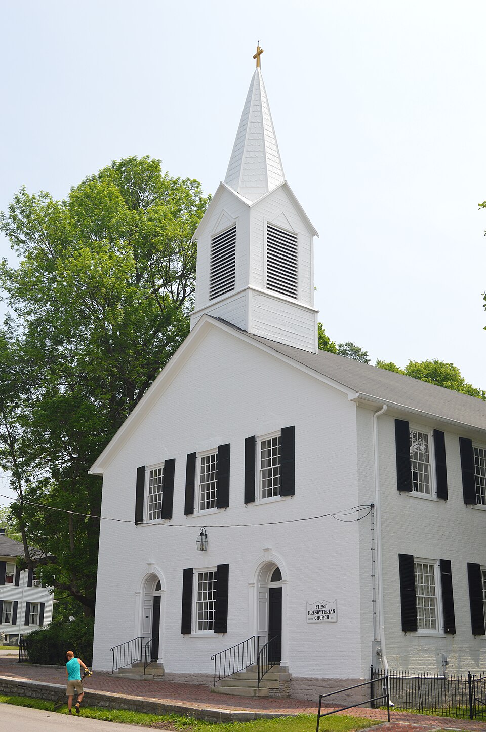
Photograph of First Presbyterian Church
Photograph by Nyttend, Public domain. Via Wikimedia Commons.

First Presbyterian Church

Listed on the National Register of Historic Places in 1977.

From the record

“The First Presbyterian Church in Flemingsburg, Kentucky is a historic church at W. It was built in 1819 and added to the National Register in 1977.”

Wikipedia article First Presbyterian Church (Flemingsburg, Kentucky), CC BY-SA 4.0.

One of 10 National Register listings published here for Fleming County · listed in 1977 · category: Building.

Sources: the Wikipedia article · the case file at the National Archives · the National Register database, National Park Service · the Wikipedia article
The listing

  • Address. W. Main and W. Water Sts., Flemingsburg, 41041
  • When was it listed? August 1977
  • Category. building
  • Census division. Flemingsburg
  • National Register reference number. 77000617 - the number the National Park Service assigned this property when it was listed, and the key its nomination file is catalogued under at the National Archives.

Mines and quarries near this property

1 within 5 miles

Regional context, not property-specific evidence. The federal mineral resources record lists 1 working within 5 miles of First Presbyterian Church: 1 producer. All of them still produce. What was taken out: Stone, Crushed/Broken. Distance is straight-line from the map coordinates, so a quarry counted here may appear on a neighbouring settlement's page as well.

Where SiteCommodity StatusRecorded
Carpenter QuarryStone, Crushed/BrokenProducer

Every working recorded in Fleming County

Storms near this property

56 since 1996

Regional context, not property-specific evidence. The National Weather Service names Flemingsburg, the town this property stands in, in 56 storm reports between 1996 and 2022: 32 thunderstorm wind, 18 hail, 5 flash flood, 1 heavy rain. No death or injury is recorded in these reports. Each account below is quoted exactly as the forecast office filed it, from the NOAA Storm Events Database, and each date opens the federal record of that event.

WhenEvent Place namedHarm What the report says
June 2004Flash FloodFlemingsburg$500,000A ten foot wall of water was flowing down Fleming Creek and caused mass destruction of homes and vehicles in the South Lick area. About four feet of water covered several roads in the Lake Tilton area.
June 2012Thunderstorm WindFlemingsburg$100,000Trees and power lines were blown down countywide.
February 2008Thunderstorm WindFlemingsburg$10,000Trees were blown down and across Highway 111 at Grange City and Hillsboro.
August 2007Thunderstorm WindFlemingsburg$10,000Numerous trees down at the intersection of Highway 57 and Taylors Mill Road.
January 2008Thunderstorm WindFlemingsburg$6,000A small barn was blown into Cherry Grove Road at Mill Creek Road. A tree was blown down across Watson Road. All damage was caused by winds estimated at 61 mph.
June 2010Thunderstorm WindFlemingsburg$5,000Four power poles were blown down between Old Convict Road and Junction Road.
February 2008Thunderstorm WindFlemingsburg$5,000Trees were blown down on Red Bud Road near Ewing at Highways 170 and 559.
August 2003Thunderstorm WindFlemingsburg$5,000Large tree limbs and power lines were down.
March 1997Thunderstorm WindFlemingsburg$5,000no account filed
August 2010Thunderstorm WindFlemingsburg$4,000Four trees were blown down from Flemingsburg towards Dalesburg on Hwy 57 and Cherry Grove Rd.
June 2010Thunderstorm WindFlemingsburg$3,000A tree was blown down onto power lines near Flemingsburg.
June 2009Thunderstorm WindFlemingsburg$2,000A couple of trees were blown down onto Turner Road.
August 2003Thunderstorm WindFlemingsburg$2,000Phone lines were down.
June 2010Thunderstorm WindFlemingsburg$1,000A tree was blown down along Helena Road near the intersection of KY Hwy 860.
June 2008Thunderstorm WindFlemingsburg$500One large tree limb was blown down at the court house by thunderstorm wind gusts.
May 2022Thunderstorm WindFlemingsburg-A tree was blown down at 14 East Water Street.
July 2022Thunderstorm WindFlemingsburg-Report of a few trees down along West Water Street near downtown Flemingsburg.
June 2020Thunderstorm WindFlemingsburg-Dispatch reported trees blown down east of Flemingsburg, from Mockingbird Hill Road to Turner Road northwest of Dalesburg.
July 2019Thunderstorm WindFlemingsburg-Dispatch reported trees blown down from the Fleming County Hospital to the east side of Flemingsburg on Crawford Street.
March 2017Thunderstorm WindFlemingsburg-Two trees were blown down.
July 2017HailFlemingsburg-A trained spotter observed half dollar sized hail just southwest of Flemingsburg.
August 2015Thunderstorm WindFlemingsburg-Trees were blown down on Mount Carmel Ave near the courthouse.
April 2015HailFlemingsburg-Hail ranging from quarter to half dollar size was reported at Fleming County High School.
August 2015Thunderstorm WindFlemingsburg-Trees were blown down on Hwy 32 inside Flemingsburg city limits.
December 2013Thunderstorm WindFlemingsburg-Several trees were blown down in Flemingsburg and around the county.
August 2013Heavy RainFlemingsburg-The 24 hour rainfall total was 2.25 inches.
April 2010HailFlemingsburg-Golf ball size hail reported in Flemingsburg.
April 2010HailFlemingsburg-Quarter size hail reported in Flemingsburg.
May 2010HailFlemingsburg-The Fleming county EOC reported hail up to one inch in diameter in Flemingsburg.
May 2010HailFlemingsburg-Quarter size hail fell at the high school in Flemingsburg.
April 2008Flash FloodFlemingsburg-Roads were closed county wide due to flood water.
April 2006Thunderstorm WindFlemingsburg-Tree's and large limbs down county wide.
April 2006Thunderstorm WindFlemingsburg-Trees down on Bypass, East Main Street, and Dye Street.
May 2005Thunderstorm WindFlemingsburg-Trees down near Flemingsburg.
June 2005Thunderstorm WindFlemingsburg-Trees down in Flemingsburg. Numerous tree limbs blown down 3 miles south of Flemingsburg.
May 2003Flash FloodFlemingsburg-Water was flooding over Kentucky Highway 11 and the road was closed.
July 2001Thunderstorm WindFlemingsburg-Trees were blown down.
August 2001Thunderstorm WindFlemingsburg-Several trees were blown down by the strong winds.
September 2000Thunderstorm WindFlemingsburg-Severe thunderstorm winds brought several trees down.
July 2000HailFlemingsburg-Large tree limbs down near KY 11 and 111.
October 1999Thunderstorm WindFlemingsburg-Several trees blown down by strong winds.
April 2015HailFlemingsburg-no account filed
May 2010HailFlemingsburg-no account filed
May 2009HailFlemingsburg-no account filed
April 2006HailFlemingsburg-no account filed
May 2005HailFlemingsburg-no account filed
March 2004HailFlemingsburg-no account filed
March 2002HailFlemingsburg-no account filed
January 1998Flash FloodFlemingsburg-no account filed
May 1998HailFlemingsburg-no account filed
May 1996HailFlemingsburg-no account filed
May 1996Flash FloodFlemingsburg-no account filed
May 1996Thunderstorm WindFlemingsburg-no account filed

Every storm recorded in Fleming County

Map coverage status

No historic map-sheet match is published for this property yet. That does not mean no map exists. This record needs a coordinate-quality review before it can be joined to a sheet boundary. Browse the county's mapped places while that work is pending.

Listed places nearby

6 within 8 miles

Other National Register properties close enough to walk or drive between, ordered by distance from this one. Both positions come from the same geocoding pass that matched these properties to their map sheets.

Photograph PropertyDistance Listed
Thomas W. Fleming House0.2 miles1979
Flemingsburg Historic District0.2 miles1985
Abraham Magowan House4.1 miles1983
Elizaville Presbyterian Church4.8 miles1977
Ben Johnson House5.4 miles1982
Franklin R. Sousley Birthplace7.0 miles1974

Sources for this property

National Archives recordThe nomination case file for reference 77000617 in Record Group 79.
Wikipedia articleCommunity-written account of this property, licensed CC BY-SA.
Fleming CountyAll 10 listed properties in this county.

Provenance

  • Listing record. National Park Service National Register of Historic Places, listed-properties dataset, current to 2026-05-22.
  • Map join. Address geocoded through the United States Census geocoder, then tested against the published boundary of every sheet in the USGS Historical Topographic Map Collection.
  • How this page is made. Listing fields come from federal records; map-sheet coverage is a labelled coordinate-to-boundary calculation, not a source-field claim.
  • Mines and quarries. USGS Mineral Resources Data System (MRDS) https://mrdata.usgs.gov/mrds/ A work of the United States government, no copyright under 17 U.S.C. 105.
  • Storms. NOAA National Centers for Environmental Information, Storm Events Database https://www.ncei.noaa.gov/stormevents/ A work of the United States government, no copyright under 17 U.S.C. 105. Narratives are quoted verbatim from the National Weather Service report and are not edited or summarised.