
BlockBefore
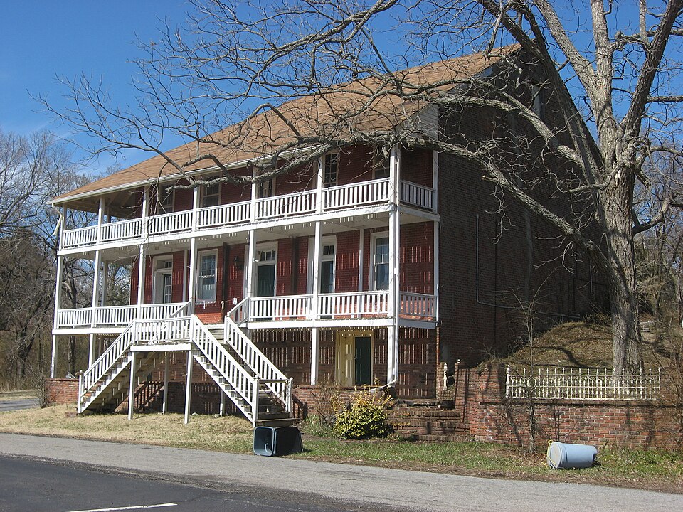
Photograph of Brick Inn
Photograph by Nyttend, Public domain. Via Wikimedia Commons.

Brick Inn

Listed on the National Register of Historic Places in 1980.

From the record

“The Brick Inn, also known as the Canton Hotel, in Canton, Kentucky, was built in 1819. It was listed on the National Register of Historic Places in 1980.”

Wikipedia article Brick Inn, CC BY-SA 4.0.

One of 8 National Register listings published here for Trigg County · listed in 1980 · category: Building.

Sources: the Wikipedia article · the case file at the National Archives · the National Register database, National Park Service

The listing

  • What is counted as historic. The nomination lists 1 building as contributing to the listing.
  • Address. Off KY 80, Canton, 42211
  • When was it listed? April 1980
  • Category. building
  • Census division. Canton
  • National Register reference number. 80001672 - the number the National Park Service assigned this property when it was listed, and the key its nomination file is catalogued under at the National Archives.

Fires near this property

21 since 1998

Regional context, not property-specific evidence. The federal wildfire occurrence database lists 21 fires within 5 miles of Brick Inn between 1998 and 2020, burning about 395 acres in total. 1 started naturally. 2 were recorded as arson. Distance is straight-line from the map coordinates, so a fire counted here may appear on a neighbouring settlement's page as well.

Reported cause Fires
Missing data/not specified/undetermined11
Equipment and vehicle use4
Debris and open burning2
Arson/incendiarism2
Natural1
Recreation and ceremony1

The most recent of them, most recent first, with the day each was reported and the service that recorded it.

DateCause SizeReported by Name on the report
1 September 2007Arson/incendiarism1.0 acresLand Between the Lakes National Recreation AreaREAL MCCOY
16 June 2007Equipment and vehicle useunder an acreLand Between the Lakes National Recreation AreaSOLDIER FIRE
31 May 2020Debris and open burningunder an acreLand Between the Lakes National Recreation AreaMALONE
18 April 2018Missing data/not specified/undeterminedunder an acreLand Between the Lakes National Recreation AreaLUNCHTIME
17 April 2014Missing data/not specified/undetermined8.3 acresLand Between the Lakes National Recreation AreaSORRY DOUG
12 April 1998Equipment and vehicle use1.0 acresKentucky Division of Forestrynot named
1 April 2007Natural1.8 acresLand Between the Lakes National Recreation AreaAPRIL FOOL
4 March 2009Recreation and ceremony50 acresKentucky Division of Forestrynot named

Every fire recorded in Trigg County

Mines and quarries near this property

1 within 5 miles

Regional context, not property-specific evidence. The federal mineral resources record lists 1 working within 5 miles of Brick Inn: 1 producer. All of them still produce. What was taken out: Stone, Crushed/Broken. Distance is straight-line from the map coordinates, so a quarry counted here may appear on a neighbouring settlement's page as well.

Where SiteCommodity StatusRecorded
Canton QuarryStone, Crushed/BrokenProducer

Every working recorded in Trigg County

Storms near this property

28 since 1996

Regional context, not property-specific evidence. The National Weather Service names Canton, the town this property stands in, in 28 storm reports between 1996 and 2025: 19 thunderstorm wind, 4 hail, 3 tornado, 1 flood. No death or injury is recorded in these reports. Each account below is quoted exactly as the forecast office filed it, from the NOAA Storm Events Database, and each date opens the federal record of that event.

WhenEvent Place namedHarm What the report says
October 2007Tornado (EF1)Canton$150,000Many large trees were downed. A boat dock was damaged by a falling tree. Part of a garage was damaged by a large tree limb. Part of a roof was blown off a house. The northeast corner of a tin roof garage was peeled back. One home sustained tree damage. Two cabins in Lake Barkley State Resort Park sustained roof damage. The state park was closed for most of the following day, mostly due to trees and power lines blocking access to the park. Peak winds were estimated up to 100 mph. The tornado occurred near the east shore of Lake Barkley.
May 2021Thunderstorm WindCanton$70,000A swath of sporadic wind damage extended along U.S. Highway 68 from the Lake Barkley bridge east to Highway 1062. A roof was severely damaged. At least several trees were down. A large open-sided machine shed collapsed. A granite monument in a cemetery was knocked over.
January 2020Tornado (EF0)Canton$50,000The tornado touched down just east of Blue Spring and tracked eastward just north of Blue Spring Road. It continued east northeast to just southwest of Cadiz. Several trees up to 3.5 feet in diameter were snapped and/or uprooted. There were several homes with minor roof damage and one that had moderate roof damage. One metal building had its garage door blown in. A large branch fell on a vehicle at one residence. A carport was shifted off its supports. Peak winds in this tornado were estimated near 85 mph.
May 2025Thunderstorm WindCanton$30,000A tree fell through the roof into a house causing water to intrude.
August 2010Thunderstorm WindCanton$20,000A boat dock on Lake Barkley was twisted and blown onto shore. A pontoon boat that had been docked there ended up next to a neighbor's dock. Numerous tree limbs were blown down.
May 2010FloodCanton$15,000High water levels on Lake Barkley caused flooding of marinas, boat ramps, and lake access roads. At Lake Barkley Marina, there was considerable damage to docks. Nine or ten roads were closed in the Linton area. A few houses in the Linton area were isolated by the swollen lake. No homes were threatened, but some lakeside residents were forced to detour around flooded roads. Water backed up into bays and tributary creeks, causing flooding inland from the lake. Most trails, roads, and camping facilities in the Land Between The Lakes National Recreation Area were closed. The lake was closed to recreational boating by order of the Coast Guard.
February 2008Thunderstorm WindCanton$10,000A structure was damaged due to wind.
February 2008Tornado (EF1)Canton$8,000Trees were uprooted and snapped during this very brief tornado. Peak winds were estimated from 85 to 90 mph.
October 2001Thunderstorm WindCanton$8,000Trees were blown down at Canton and in Cadiz. Power poles were blown down 4 miles south of Cadiz. One pole landed in front of a vehicle, causing the driver to swerve and lose control. The driver received only minor injuries.
April 2007Thunderstorm WindCanton$7,000A metal roof was blown off a home. The house was located in a lakeshore subdivision along Lake Barkley. Parts of the roof landed in tree branches and around the neighborhood.
June 2019Thunderstorm WindCanton$4,000Trees were blown down.
March 2006Thunderstorm WindCanton$4,000Trees were blown down in Canton. A spotter estimated wind gusts to 60 MPH in Cadiz, which damaged gutters on a home.
June 2016Thunderstorm WindCanton$3,000A tree was down along Highway 164. All of the construction barrels on the U.S. Highway 68 bridge over Lake Barkley were missing.
July 1997Thunderstorm WindCanton$2,000Trees were blown down at Barkley Lodge.
May 2025Thunderstorm WindCanton$1,200NWS damage survey team found extensive straight line wind damage occurred in the Cumberland Shores community on the eastern side of Lake Barkley. Estimated winds were 80-90 mph. Numerous trees were uprooted, including one that feel onto a home, causing major damage. A few homes near and east of Donaldson sustained shingle damage as well.
July 2016Thunderstorm WindCanton-A wind gust was measured to 60 mph.
June 2014Funnel CloudCanton-A funnel cloud was reported near Canton moving toward Cadiz.
August 2006Thunderstorm WindCanton-Several tree limbs were down, along with a whole tree that was uprooted.
March 2005HailCanton-Dime size hail was reported near Golden Pond (in the Land Between The Lakes National Recreation Area) and west of Cadiz, near Lake Barkley.
June 2004Thunderstorm WindCanton-Trees were blown down on Highway 274 near Rockcastle. Four trees from 6 to 8 inches in diameter were blown down in Canton.
August 2003Thunderstorm WindCanton-A co-operative observer reported several trees blown down.
August 2003HailCanton-A co-operative observer reported 1 inch hail.
July 2003Thunderstorm WindCanton-Trees were blown down.
July 1997Thunderstorm WindCanton-A couple trees were blown across a state highway near Canton.
March 2017HailCanton-no account filed
March 2012Thunderstorm WindCanton-no account filed
July 1996Thunderstorm WindCanton-no account filed

Every storm recorded in Trigg County

Map coverage status

No historic map-sheet match is published for this property yet. That does not mean no map exists. This record needs a coordinate-quality review before it can be joined to a sheet boundary. Browse the county's mapped places while that work is pending.

Sources for this property

National Archives recordThe nomination case file for reference 80001672 in Record Group 79.
Wikipedia articleCommunity-written account of this property, licensed CC BY-SA.
Trigg CountyAll 8 listed properties in this county.

Provenance

  • Listing record. National Park Service National Register of Historic Places, listed-properties dataset, current to 2026-05-22.
  • Map join. Address geocoded through the United States Census geocoder, then tested against the published boundary of every sheet in the USGS Historical Topographic Map Collection.
  • How this page is made. Listing fields come from federal records; map-sheet coverage is a labelled coordinate-to-boundary calculation, not a source-field claim.
  • Wildfire. Short, Karen C. 2022. Spatial wildfire occurrence data for the United States, 1992-2020 [FPA_FOD_20221014]. 6th Edition. Fort Collins, CO: Forest Service Research Data Archive. https://doi.org/10.2737/RDS-2013-0009.6 Collected with United States Government funding and usable without additional permissions or fees.
  • Mines and quarries. USGS Mineral Resources Data System (MRDS) https://mrdata.usgs.gov/mrds/ A work of the United States government, no copyright under 17 U.S.C. 105.
  • Storms. NOAA National Centers for Environmental Information, Storm Events Database https://www.ncei.noaa.gov/stormevents/ A work of the United States government, no copyright under 17 U.S.C. 105. Narratives are quoted verbatim from the National Weather Service report and are not edited or summarised.