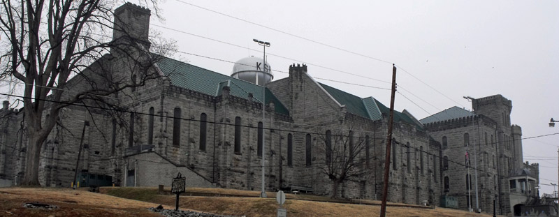
| March 2017 | Thunderstorm Wind | Eddyville | 3 hurt, $50,000 | Significant damage occurred at the Kentucky State Penitentiary. Three staff members at the penitentiary were injured by flying glass, debris, and equipment picked up by the wind. Their injuries were not life threatening. The roof was blown off the prison gym. The resident of a mobile home in Eddyville estimated winds gusted to around 75 mph. The resident said their mobile home was rocking in the wind. |
| June 2006 | Thunderstorm Wind | Eddyville | $150,000 | A National Weather Service damage survey indicated a downburst with gusts up to 85 MPH occurred near the east shore of Lake Barkley in an area known as Eddy Creek. The damage area was about 2 miles wide and 3.5 miles long. The north to south extent of the damage was along Kentucky 93 from the north side of Eddy Bay to the community of Confederate. The west to east extent of the damage was from Lake Barkley to just east of Interstate 24. Hundreds of large trees were snapped or uprooted. Many trees were downed at a resort on the lake, damaging three permanent campers. A few motorists were stranded between downed trees and power lines across roads. A private boat dock was heavily damaged, along with a boat. About a half dozen homes and structures sustained roof and siding damage, which was mainly minor. Three homes were damaged when trees fell on them. One lane of eastbound Interstate 24 near the 49 mile marker was blocked for several hours by downed trees. A canopy was blown off a gas station. Widespread power outages lasted into the following day. |
| April 2011 | Tornado (EF1) | Eddyville | $100,000 | The intermittent damage path began along Highway 373, producing mainly tree damage. Further northeast, barns and trees were damaged, along with shingles off roofs. Peak winds were estimated near 95 mph. The average path width was 75 yards. The tornado continued northeast into Caldwell County. |
| July 2016 | Thunderstorm Wind | Eddyville | $25,000 | Four power poles with transformers were blown down. |
| July 2023 | Thunderstorm Wind | Eddyville | $20,000 | A tree fell on a vehicle. |
| March 2006 | Thunderstorm Wind | Eddyville | $20,000 | In Kuttawa, the roof of a laundromat was blown off, and the retainer wall at a post office collapsed. A farm shed was destroyed in Eddyville. In the Land Between The Lakes Recreation Area, numerous trees fell at the Hillman Ferry Campground, including some that landed on roads and a rest room building. |
| May 2006 | Thunderstorm Wind | Eddyville | $20,000 | At the Eddy Creek Marina, a floating breakwater dock was blown about 15 feet. About a dozen 5/8-inch thick steel cables snapped, causing the dock to float away. A power failure and a small fire ensued. |
| February 2019 | Flood | Eddyville | $10,000 | The level of Kentucky Lake was raised to 367 feet, about 8 feet above the normal summer pool stage. Low-lying parks, campgrounds, and marina parking lots near the lake were flooded. Some lake access roads were underwater. The lake level was still several feet below the record set during the spring of 2011 flood. |
| March 2018 | Flood | Eddyville | $10,000 | Flooding along the lakeshore of Lake Barkley inundated parks, boat ramps, parking lots, and a few access roads. Some campsites were flooded at campgrounds. The lake level rose to nearly 365 feet due to restricted water releases at Barkley Dam. The water was held back to mitigate flooding on the Ohio River. The Lake Barkley winter pool stage is 355 feet, and the normal summer pool stage is 359 feet. |
| May 2015 | Thunderstorm Wind | Eddyville | $7,000 | In Eddyville, large tree branches were down, along with some power lines. A trampoline was blown about 200 yards. At the intersection of U.S. Highways 641 and 62, debris was blown into power lines. Trees were down on U.S. Highway 641 just north of Eddyville. |
| January 1996 | Thunderstorm Wind | Eddyville | $6,000 | no account filed |
| July 2023 | Thunderstorm Wind | Eddyville | $5,000 | Trees were down. |
| June 2018 | Thunderstorm Wind | Eddyville | $5,000 | Severe thunderstorm winds occurred over much of the county. Three state roads were closed by downed trees. A trained spotter estimated winds gusted to 60 mph at Eddyville. |
| May 1998 | Thunderstorm Wind | Eddyville | $5,000 | Trees were down on three highways near Eddyville. |
| May 1999 | Thunderstorm Wind | Eddyville | $4,000 | Trees and power lines were down along Oak Grove Road. |
| January 1999 | Thunderstorm Wind | Eddyville | $3,000 | A tree and a couple of power lines were down. |
| July 2023 | Thunderstorm Wind | Eddyville | $1,000 | A tree was down over the road at Kentucky 293 and 1415. |
| June 2019 | Thunderstorm Wind | Eddyville | $1,000 | A power line was down. |
| December 2015 | Heavy Rain | Eddyville | - | The rainfall total over the past seven days was 8.14 inches. Of that total, 2.05 inches fell since midnight on the 28th. A couple of roads were closed that routinely become covered with water in heavy rain events. |
| July 2011 | Heavy Rain | Eddyville | - | A trained spotter reported 1.5 inches of rain and still falling heavily. |
| April 2011 | Hail | Eddyville | - | Golf-ball hail was reported at the state penitentiary. |
| May 2010 | Flood | Eddyville | - | Seven roadways were closed in the county. Water was around a bridge on Eddy Creek. Debris from high water was near the bridge on Highway 730 at Highway 293. |
| March 2008 | Flood | Eddyville | - | Water was over Kentucky 1943, but the road remained open. |
| April 2008 | Flood | Eddyville | - | Many roads were covered by water. Highways 295 and 819 were closed in places. |
| December 2007 | Heavy Rain | Eddyville | - | Kentucky Highway 1943 was closed between mile markers 3 and 4 due to high water. |
| September 2006 | Flood | Eddyville | - | Kentucky Highway 1943 was closed north of Eddyville due to high water. |
| August 2006 | Heavy Rain | Eddyville | - | Several inches of water were over a local road. Both lanes were closed briefly. |
| January 2004 | Lightning | Eddyville | - | Lightning struck the water tower at the Kentucky State Penitentiary near Eddyville. The lightning strike caused a break in a 12-inch supply line, which emptied the tower of more than 350,000 gallons of water. The rupture forced the facility to go without running water for a while. Boilers that heat the facility were temporarily out of service. |
| April 1998 | Hail | Eddyville | - | Dime size hailstones whitened the ground. |
| November 1998 | Thunderstorm Wind | Eddyville | - | A few small trees and limbs were down. |
| March 2020 | Hail | Eddyville | - | no account filed |
| October 2006 | Flood | Eddyville | - | no account filed |
| April 2004 | Hail | Eddyville | - | no account filed |
| June 1998 | Flash Flood | Eddyville | - | no account filed |
| March 1997 | Flash Flood | Eddyville | - | no account filed |
| March 1997 | Flash Flood | Eddyville | - | no account filed |
| May 1996 | Thunderstorm Wind | Eddyville | - | no account filed |
| April 1995 | Hail | Eddyville | - | no account filed |
| May 1995 | Hail | Eddyville | - | no account filed |
| May 1995 | Thunderstorm Wind | Eddyville | - | no account filed |
| May 1995 | Hail | Eddyville | - | no account filed |
 Block