 Block
From the record
One of 72 National Register listings published here for Campbell County · listed in 1983 · category: Building.
Sources: the case file at the National Archives · the National Register database, National Park Service
Listed on the National Register of Historic Places in 1983.
One of 72 National Register listings published here for Campbell County · listed in 1983 · category: Building.
Sources: the case file at the National Archives · the National Register database, National Park Service
Regional context, not property-specific evidence. The federal mineral resources record lists 2 workings within 5 miles of Reitman House: 1 prospect, 1 past producer. None of them still produces. What was taken out: Clay, Sand and Gravel, Construction. Distance is straight-line from the map coordinates, so a quarry counted here may appear on a neighbouring settlement's page as well.
| Where | Site | Commodity | Status | Recorded |
|---|---|---|---|---|
| Brewer Co Plant No 10 Pit | Sand and Gravel, Construction | Past Producer | ||
| Brush Creek Clay | Clay | Prospect |
Regional context, not property-specific evidence. The National Weather Service names Alexandria, the town this property stands in, in 51 storm reports between 1997 and 2025: 22 thunderstorm wind, 18 hail, 8 flash flood, 3 flood. No death or injury is recorded in these reports. Each account below is quoted exactly as the forecast office filed it, from the NOAA Storm Events Database, and each date opens the federal record of that event.
| When | Event | Place named | Harm | What the report says |
|---|---|---|---|---|
| May 2011 | Thunderstorm Wind | Alexandria | $20,000 | Heavy tree damage occurred in a cemetery. Most of these trees were snapped off and uprooted. There was minor structural damage to roofs and shingles on a few residences. Damaging thunderstorms winds were determined to be the cause. |
| December 2013 | Thunderstorm Wind | Alexandria | $10,000 | Numerous large trees were down in Alexandria and surrounding areas due to thunderstorm winds. |
| August 2013 | Thunderstorm Wind | Alexandria | $10,000 | A tree fell on a house near Alexandria due to thunderstorm winds. |
| June 2012 | Thunderstorm Wind | Alexandria | $10,000 | Numerous trees were reported down due to damaging thunderstorm winds. |
| June 2008 | Flash Flood | Alexandria | $10,000 | A road near State Route 10 was washed out. High water closed several other roads throughout the county. |
| March 2008 | Flood | Alexandria | $10,000 | Several roads were flooded and closed, including Dodsworth Lane at State Routes 8 and 1998, Twelvemile Road in Oneonta, and State Route 9 at Interstate 275 in Highland Heights. |
| July 1997 | Thunderstorm Wind | Alexandria | $10,000 | Trees downed. |
| June 2008 | Thunderstorm Wind | Alexandria | $8,000 | Trees were knocked down across the county. |
| May 2022 | Thunderstorm Wind | Alexandria | $5,000 | Several trees were downed in the Alexandria area. |
| April 2020 | Thunderstorm Wind | Alexandria | $5,000 | Numerous trees with 6 inch diameter trunks were knocked down. |
| July 2019 | Thunderstorm Wind | Alexandria | $5,000 | Numerous trees were downed in the Alexandria area. |
| March 2017 | Thunderstorm Wind | Alexandria | $5,000 | A large tree was downed and a porch was uplifted and blown downwind several hundred feet. |
| July 2010 | Flash Flood | Alexandria | $5,000 | Part of Lower Tug Fork Road was washed away by flood waters. |
| June 2005 | Thunderstorm Wind | Alexandria | $5,000 | Trees were knocked down. |
| June 1998 | Thunderstorm Wind | Alexandria | $5,000 | Numerous trees downed. |
| November 1998 | Thunderstorm Wind | Alexandria | $5,000 | Trees were blown down, one of which blew through a store window. |
| June 1998 | Thunderstorm Wind | Alexandria | $3,000 | Trees and power lines downed. |
| April 2020 | Thunderstorm Wind | Alexandria | $2,000 | Multiple power lines were snapped at the intersection of U.S. 27 and Poplar Ridge Road. |
| April 2007 | Hail | Alexandria | $2,000 | no account filed |
| May 2025 | Thunderstorm Wind | Alexandria | $1,000 | A large, hardwood tree was split. |
| January 2012 | Flood | Alexandria | $1,000 | Several rural roads in the county were reported closed due to high water caused by recent heavy rain. |
| May 2011 | Thunderstorm Wind | Alexandria | $1,000 | Large branches were reported broken due to damaging thunderstorm winds. |
| September 2010 | Thunderstorm Wind | Alexandria | $1,000 | Trees were reported down due to damaging thunderstorm winds. |
| November 2007 | Hail | Alexandria | $1,000 | no account filed |
| August 2024 | Flash Flood | Alexandria | - | A road was closed due to high water flowing across it. |
| September 2018 | Flood | Alexandria | - | A couple of roads were closed due to high water. |
| February 2018 | Flash Flood | Alexandria | - | Multiple roads were closed throughout the county due to high water. |
| October 2016 | Flash Flood | Alexandria | - | A few roads across Kenton County were closed due to high water. |
| June 2009 | Thunderstorm Wind | Alexandria | - | Large limbs were blown down in the eastern part of the county. |
| March 2006 | Flash Flood | Alexandria | - | Numerous roads were flooded. A few homes sustained basement flooding in town. |
| July 2006 | Flash Flood | Alexandria | - | Water was knee deep along Alexandria Pike. |
| May 2002 | Flash Flood | Alexandria | - | Three roads were closed by high water in town. |
| June 2000 | Hail | Alexandria | - | Nickel hail was reported. |
| April 2025 | Hail | Alexandria | - | no account filed |
| April 2020 | Hail | Alexandria | - | no account filed |
| April 2018 | Hail | Alexandria | - | no account filed |
| August 2015 | Hail | Alexandria | - | no account filed |
| August 2015 | Hail | Alexandria | - | no account filed |
| August 2015 | Hail | Alexandria | - | no account filed |
| April 2012 | Thunderstorm Wind | Alexandria | - | no account filed |
| April 2012 | Hail | Alexandria | - | no account filed |
| July 2012 | Hail | Alexandria | - | no account filed |
| July 2012 | Hail | Alexandria | - | no account filed |
| July 2011 | Hail | Alexandria | - | no account filed |
| June 2011 | Hail | Alexandria | - | no account filed |
| June 2009 | Hail | Alexandria | - | no account filed |
| May 2006 | Thunderstorm Wind | Alexandria | - | no account filed |
| July 1998 | Hail | Alexandria | - | no account filed |
| June 1998 | Hail | Alexandria | - | no account filed |
| July 1997 | Hail | Alexandria | - | no account filed |
| March 1997 | Thunderstorm Wind | Alexandria | - | no account filed |
No historic map-sheet match is published for this property yet. That does not mean no map exists. This record needs a coordinate-quality review before it can be joined to a sheet boundary. Browse the county's mapped places while that work is pending.
Other National Register properties close enough to walk or drive between, ordered by distance from this one. Both positions come from the same geocoding pass that matched these properties to their map sheets.
| Photograph | Property | Distance | Listed |
|---|---|---|---|
| Uebel House | 0.6 miles | 1983 | |
| Peter Barth Farm | 0.6 miles | 1983 | |
 | Reitman's St.Joseph House | 0.6 miles | 1983 |
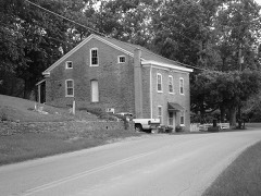 | Blau's Four Mile House | 0.7 miles | 1983 |
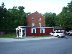 | Matthias Kremer House | 0.7 miles | 1983 |
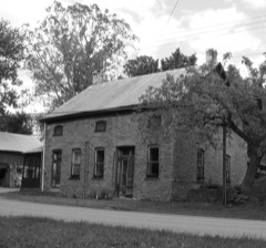 | Kort Grocery | 0.7 miles | 1983 |
| National Archives record | The nomination case file for reference 83002612 in Record Group 79. |
| Campbell County | All 72 listed properties in this county. |