 Block
From the record
One of 11 National Register listings published here for Hancock County · listed in 1984 · category: Building.
Sources: the case file at the National Archives · the National Register database, National Park Service
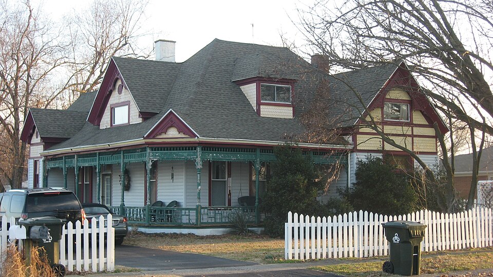
Listed on the National Register of Historic Places in 1984.
One of 11 National Register listings published here for Hancock County · listed in 1984 · category: Building.
Sources: the case file at the National Archives · the National Register database, National Park Service
Regional context, not property-specific evidence. The federal wildfire occurrence database lists 3 fires within 5 miles of Horace Patterson House between 2001 and 2010, burning about 201 acres in total. None started naturally. None was recorded as arson. Distance is straight-line from the map coordinates, so a fire counted here may appear on a neighbouring settlement's page as well.
| Reported cause | Fires |
|---|---|
| Recreation and ceremony | 1 |
| Missing data/not specified/undetermined | 1 |
| Debris and open burning | 1 |
The most recent of them, most recent first, with the day each was reported and the service that recorded it.
| Date | Cause | Size | Reported by | Name on the report |
|---|---|---|---|---|
| 6 April 2001 | Debris and open burning | 95 acres | Hoosier National Forest | NEWTONVILLE |
| 11 March 2010 | Recreation and ceremony | 8.0 acres | Kentucky Division of Forestry | not named |
| 27 February 2006 | Missing data/not specified/undetermined | 98 acres | Kentucky Division of Forestry | not named |
Regional context, not property-specific evidence. The federal mineral resources record lists 9 workings within 5 miles of Horace Patterson House: 6 producers, 2 unknowns, 1 past producer. 6 still produce. What was taken out: Clay. Distance is straight-line from the map coordinates, so a quarry counted here may appear on a neighbouring settlement's page as well.
| Where | Site | Commodity | Status | Recorded |
|---|---|---|---|---|
| American Olean Tile Tract No. 1 | Clay | Producer | ||
| American Olean Tile Tract No. 1 | Clay | Producer | ||
| American Olean Tile Tract No. 2 | Clay | Producer | ||
| Can-Tex Pit | Clay | Producer | ||
| Cannelton Mine | Clay | Unknown | ||
| Lewisport Mine No. 3 | Clay | Unknown | ||
| Lewisport Shale Plant | Clay | Producer | ||
| Owensboro Brick Plant | Clay | Producer | ||
| West Point Brick and Clay Pit | Clay | Past Producer |
Regional context, not property-specific evidence. The National Weather Service names Lewisport, the town this property stands in, in 40 storm reports between 1998 and 2025: 28 thunderstorm wind, 5 hail, 4 flash flood, 2 flood. No death or injury is recorded in these reports. Each account below is quoted exactly as the forecast office filed it, from the NOAA Storm Events Database, and each date opens the federal record of that event.
| When | Event | Place named | Harm | What the report says |
|---|---|---|---|---|
| April 2016 | Thunderstorm Wind | Lewisport | $30,000 | A Hancock County official reported several trees down in the area, one of which fell on a truck. The majority of the storm damage was reported in the Lewisport area. |
| July 2017 | Thunderstorm Wind | Lewisport | $25,000 | State officials reported several trees down in the area due to severe thunderstorm winds. One tree fell onto a house. |
| July 2016 | Thunderstorm Wind | Lewisport | $15,000 | Local law enforcement reported a tree fell on a vehicle due to severe thunderstorm winds. |
| September 2018 | Tornado (EF0) | Lewisport | $6,000 | This tree-top level tornado did all of its damage 20 to 30 feet above ground. Never more than 50 yards wide, the first evidence of the tornado touching down was one mile south of the water tower on Thomas Lane, where it downed several large branches that blocked the road. Moving northeast over forested land, the next evidence was more tree trunks and branches snapped on Poplar Grove Rd just north of the intersection with Hilldale Rd. The tornado then continued to skip northeast, snapping branches and trunks to the west of Frank Luttrell Rd, before crossing the road and causing minor roof damage to the metal roof of a barn and snapping more tree limbs a third of a mile southeast of North Hancock Elementary School. The tornado dropped small branches and leaves along its path as it continued northeast. The last major tree damage was observed around a home on Adair Rd, where trees were uprooted and trunks snapped in a cyclonic pattern around the home. The only damage to the home, however, was minor roof damage from a branch falling on it. The storm then crossed Adair Rd, lifting somewhere in a wooded area west of a large pond near Beauchamp Lane, where residents witnessed its dissipation. |
| July 2017 | Thunderstorm Wind | Lewisport | $5,000 | Severe thunderstorm winds peeled the roof off a home on Lake Street in Lewisport. |
| January 2012 | Thunderstorm Wind | Lewisport | $5,000 | Local law enforcement reported that a storage building was destroyed. Roof damage was noted with a few nearby homes. |
| January 2012 | Thunderstorm Wind | Lewisport | $5,000 | An amateur radio operator reported that a barn was destroyed along State Highway 334. |
| July 2016 | Thunderstorm Wind | Lewisport | $2,000 | Local law enforcement reported trees down on a power line blocking Sand Hill Road. |
| April 2025 | Thunderstorm Wind | Lewisport | - | A tree was blocking the driveway of Heartland Villa. |
| July 2024 | Thunderstorm Wind | Lewisport | - | Power lines were downed along McGill Lane in Lewisport. |
| June 2023 | Thunderstorm Wind | Lewisport | - | Scattered trees were down county wide. Some were impacting power lines. |
| June 2023 | Flash Flood | Lewisport | - | Flash flooding was identified around Riverview Drive and Holland Avenue. There were also flooding issues on US 60 about 1 mile east of Lewisport. |
| August 2020 | Flash Flood | Lewisport | - | County Route 657 was closed due to flooding. |
| March 2019 | Thunderstorm Wind | Lewisport | - | Trees were reported down at Roberts Lane in Lewisport, Kentucky. |
| October 2019 | Thunderstorm Wind | Lewisport | - | A tree was reported down on State Road 334 between Lewisport and the county line. There was also general wind damage in Lewisport. |
| October 2019 | Thunderstorm Wind | Lewisport | - | Power lines and trees were down on Pell Street in Lewisport. |
| February 2018 | Flood | Lewisport | - | Numerous roads closed across county due to high water, including KY 334, KY 3543, KY 3101, KY 1403, KY 661, and KY 1389. |
| May 2016 | Thunderstorm Wind | Lewisport | - | The Hancock emergency manager reported 4 to 5 trees down over roadways in the Lewisport area. |
| June 2013 | Thunderstorm Wind | Lewisport | - | The local emergency manager estimated that winds up to 70 mph downed several trees in Lewisport. |
| April 2011 | Flood | Lewisport | - | An observer reported 2.89 inches of rain, resulting in several county road closures. |
| April 2011 | Thunderstorm Wind | Lewisport | - | The Kentucky mesonet site in Hancock county measured a wind gust of 66 mph. |
| June 2011 | Thunderstorm Wind | Lewisport | - | A fully mature tree knocked down in northern Hancock County. Several power lines were downed as well. |
| July 2010 | Thunderstorm Wind | Lewisport | - | A trained spotter reported estimated thunderstorm winds of up to 60 mph. |
| July 2008 | Thunderstorm Wind | Lewisport | - | Several large tree limbs were reported down. |
| May 2006 | Thunderstorm Wind | Lewisport | - | Several trees were blown down. |
| June 2006 | Flash Flood | Lewisport | - | Sand Hill Road and U.S. Highway 60 were closed due to high water. |
| September 2006 | Flash Flood | Lewisport | - | Some streets were flooded. Some were closed and impassable. |
| September 2006 | Thunderstorm Wind | Lewisport | - | Trees and power lines were downed. |
| April 2005 | Thunderstorm Wind | Lewisport | - | Trees and power lines were downed. |
| July 2004 | Thunderstorm Wind | Lewisport | - | Numerous trees and power lines were blown down. |
| June 1998 | Hail | Lewisport | - | Co-op observer reported dime size hail. |
| June 2006 | Hail | Lewisport | - | no account filed |
| June 2006 | Thunderstorm Wind | Lewisport | - | no account filed |
| June 2006 | Thunderstorm Wind | Lewisport | - | no account filed |
| September 2006 | Hail | Lewisport | - | no account filed |
| August 2005 | Thunderstorm Wind | Lewisport | - | no account filed |
| November 2005 | Thunderstorm Wind | Lewisport | - | no account filed |
| June 1998 | Hail | Lewisport | - | no account filed |
| May 1998 | Thunderstorm Wind | Lewisport | - | no account filed |
| May 1998 | Hail | Lewisport | - | no account filed |
No historic map-sheet match is published for this property yet. That does not mean no map exists. This record needs a coordinate-quality review before it can be joined to a sheet boundary. Browse the county's mapped places while that work is pending.
Other National Register properties close enough to walk or drive between, ordered by distance from this one. Both positions come from the same geocoding pass that matched these properties to their map sheets.
| Photograph | Property | Distance | Listed |
|---|---|---|---|
 | Joe Pell Building | under 500 feet | 1984 |
 | Lewisport Masonic Lodge | under 500 feet | 1984 |
 | Taylor, J. B., and Son Feed Store | under 500 feet | 1984 |
 | Isaac R. Hayden House | 0.2 miles | 1984 |
 | Tom Henderson House | 0.2 miles | 1984 |
| Samuel Pate House | 3.5 miles | 1978 |
| National Archives record | The nomination case file for reference 84001543 in Record Group 79. |
| Hancock County | All 11 listed properties in this county. |