 Block
From the record
One of 15 National Register listings published here for Floyd County · listed in 1989 · category: Building.
Sources: the case file at the National Archives · the National Register database, National Park Service

Listed on the National Register of Historic Places in 1989.
One of 15 National Register listings published here for Floyd County · listed in 1989 · category: Building.
Sources: the case file at the National Archives · the National Register database, National Park Service
Regional context, not property-specific evidence. The federal wildfire occurrence database lists 176 fires within 5 miles of US Post Office-Prestonsburg between 1997 and 2020, burning about 7,535 acres in total. None started naturally. 36 were recorded as arson. Distance is straight-line from the map coordinates, so a fire counted here may appear on a neighbouring settlement's page as well.
| Reported cause | Fires |
|---|---|
| Debris and open burning | 58 |
| Missing data/not specified/undetermined | 40 |
| Recreation and ceremony | 37 |
| Arson/incendiarism | 36 |
| Smoking | 2 |
| Railroad operations and maintenance | 2 |
| Misuse of fire by a minor | 1 |
The most recent of them, most recent first, with the day each was reported and the service that recorded it.
| Date | Cause | Size | Reported by | Name on the report |
|---|---|---|---|---|
| 9 September 2010 | Debris and open burning | 1.0 acres | Kentucky Division of Forestry | ABBOTT MTN |
| 8 September 2007 | Missing data/not specified/undetermined | 1.0 acres | Kentucky Division of Forestry | not named |
| 8 September 2002 | Missing data/not specified/undetermined | 1.0 acres | Kentucky Division of Forestry | not named |
| 25 September 2005 | Missing data/not specified/undetermined | 1.0 acres | Kentucky Division of Forestry | not named |
| 10 September 2010 | Recreation and ceremony | 1.0 acres | Kentucky Division of Forestry | GAS FORK |
| 30 August 2007 | Debris and open burning | 3.0 acres | Kentucky Division of Forestry | not named |
| 15 August 2002 | Recreation and ceremony | 1.0 acres | Kentucky Division of Forestry | not named |
| 20 June 2012 | Recreation and ceremony | under an acre | Kentucky Division of Forestry | AUXIER |
Regional context, not property-specific evidence. The federal mineral resources record lists 2 workings within 5 miles of US Post Office-Prestonsburg: 2 past producers. None of them still produces. What was taken out: Sand and Gravel, Construction, Silica. Distance is straight-line from the map coordinates, so a quarry counted here may appear on a neighbouring settlement's page as well.
| Where | Site | Commodity | Status | Recorded |
|---|---|---|---|---|
| Allen Plant | Sand and Gravel, Construction | Past Producer | ||
| Levisa Fork Sandstone Pit | Silica | Past Producer |
Regional context, not property-specific evidence. The National Weather Service names Prestonsburg, the town this property stands in, in 121 storm reports between 1996 and 2025: 55 thunderstorm wind, 25 hail, 24 flash flood, 13 flood. The reports record 1 death. Each account below is quoted exactly as the forecast office filed it, from the NOAA Storm Events Database, and each date opens the federal record of that event.
| When | Event | Place named | Harm | What the report says |
|---|---|---|---|---|
| May 2019 | Thunderstorm Wind | Prestonsburg | 1 killed, $155,000 | A National Weather Service Meteorologist surveyed localized downburst winds in Prestonsburg. These winds caused sporadic damage throughout the community. The highest wind gust estimated was in downtown Prestonsburg on West Court Street |where one half of the roof of a hock shop building was lifted off. This roof landed on West Court Street, including on multiple vehicles, fatally wounding one person in a moving vehicle. Glass was also broken on multiple windows on the north side of the building. There were a number of other buildings and homes with minor roof |or gutter damage nearby, as well as a couple of uprooted trees near the downtown area. A HAM radio tower that had been mounted on the top of the annex building beside the jail and behind the courthouse in downtown Prestonsburg was also destroyed by thunderstorm wind gusts. The winds snapped the support wires that had been holding up the tower causing the tower to break in half and fall onto the roof of the building it had been mounted on and the ground next to the building. Wind speeds that uprooted a tree at a residence on South Highland Avenue were estimated to be in the upper end of the 70 to 80 mph range. |
| June 2012 | Thunderstorm Wind | Prestonsburg | $50,000 | There were numerous calls of trees and power lines down. |
| June 2008 | Thunderstorm Wind | Prestonsburg | $50,000 | Numerous trees and power lines were blown down at the Jenny Wiley State Park. Part of one tree fell on a building. Several boats were blown loose from the dock on Dewey Lake. One tree was blown down on a vehicle near Dewey Lake. |
| June 2001 | Flash Flood | Prestonsburg | $40,000 | Raging water in the Middle Creek forced several families from their homes after heavy rains fell across the area. Several mobile homes were flooded leaving a coating of mud throughout the interior. One car was washed up against a tree. Eight residences were affected by the high waters and 5 families had to be evacuated. |
| February 2019 | Flash Flood | Prestonsburg | $35,000 | A spotter observed 3-4 foot deep water flowing over Abbott Creek Road near Bonanza. Creekside Subdivision had homes with water entering their crawl spaces, while a truck was picked up by the quickly flowing water. |
| September 1998 | Flash Flood | Prestonsburg | $30,000 | Flash flooding occurred Monday afternoon for about one hour at Stratton Branch. The water roared down a hillside and knocked buildings from their foundation, pulled a culvert loose and tore up chunks of pavement. Two mobile homes sustained flood damage. |
| May 2019 | Thunderstorm Wind | West Prestonsburg | $25,000 | Emergency Management reported tree damage southwest of Prestonsburg, including one falling on a house as well as the top of a pear tree being broken off. |
| May 2011 | Flood | West Prestonsburg | $25,000 | Hwy 1427, also known as Abbott Creek Road, had one and one and a half feet of water flowing over it three miles from the junction with Hwy 23. |
| January 2008 | Thunderstorm Wind | Prestonsburg | $25,000 | The Road Dept responded to reports of approximately 25 trees blocking roads all across the county. Highway 3190 was still blocked by downed trees as of 230 pm EST. This damage was caused by wind gusts estimated at 63 mph. |
| June 2022 | Thunderstorm Wind | Prestonsburg | $20,000 | A large tree was uprooted and blown over near the corner of Scott Lane and Dingus Street. Numerous other trees were blow down in the city of Prestonsburg including one that was blown down and onto a mobile home. |
| February 1998 | Thunderstorm Wind | Prestonsburg | $15,000 | no account filed |
| April 1996 | Thunderstorm Wind | Prestonsburg | $15,000 | no account filed |
| December 2019 | Flood | Prestonsburg | $10,000 | Local media reported flooding due to heavy rain in Archer Park in Prestonsburg. This caused damage to the city's Christmas lights display as the Levisa Fork of the Big Sandy River rose to 20 feet, causing the river to overspill its banks into the park. |
| May 1996 | Flash Flood | Prestonsburg | $10,000 | no account filed |
| February 2009 | Thunderstorm Wind | Prestonsburg | $8,000 | Large limbs were blown down by thunderstorm wind gusts. One half and two third inch diameter hail was also reported. Power outages were reported along with winds of 50 to 60 mph. |
| April 2006 | Thunderstorm Wind | Prestonsburg | $8,000 | At Estill on Route 7, several large trees blown down. One tree toppled onto power line and resting on top of storage building. Severe roof damage to 4 homes. |
| May 2009 | Flash Flood | Prestonsburg | $5,000 | Some stuctural and crop damage is visible. Low lying areas along the creek are flooding between mile markers 6 and 10. The creek is receding upstream of the elementary school. Water is up to and into the basements and possibly lowest levels of a few homes and businesses adjacent to Middle Creek in the community along Clark Drive on KY 114. |
| February 2008 | Thunderstorm Wind | Prestonsburg | $5,000 | A railroad crossing was blown down. Some trees were also blown down across the road near the Mountain Arts Center. |
| February 2008 | Thunderstorm Wind | Prestonsburg | $5,000 | Trees were blown down onto Highway 114. |
| May 2004 | Thunderstorm Wind | Prestonsburg | $5,000 | Trees and power lines were down in Abbott. |
| July 2001 | Flash Flood | Prestonsburg | $5,000 | Flood waters from Abbott Creek washed a car off of Kentucky Highway 1447. No injuries were reported. |
| January 1997 | Thunderstorm Wind | Prestonsburg | $5,000 | no account filed |
| February 2009 | Thunderstorm Wind | Prestonsburg | $4,000 | In the Emma area numerous limbs and one tree were blown down. A barn roof was also damaged. |
| July 2005 | Lightning | Prestonsburg | $3,000 | Lightning stuck a house and set it on fire. Numerous power outages across the city. |
| July 1997 | Thunderstorm Wind | Prestonsburg | $3,000 | Power lines were downed. |
| February 2009 | Thunderstorm Wind | Prestonsburg | $2,500 | Two or 3 trees were down and lying across Highway 114. |
| February 2009 | Thunderstorm Wind | Prestonsburg | $2,500 | Two or three trees were blown down and across Hwy 114. |
| July 2011 | Thunderstorm Wind | Prestonsburg | $2,000 | Large tree limbs were blown down. |
| July 2008 | Thunderstorm Wind | Prestonsburg | $2,000 | Two trees were blown down by thunderstorm wind gusts. |
| July 2007 | Thunderstorm Wind | Prestonsburg | $2,000 | Two trees down on State Route 1427. |
| February 2015 | Flood | Prestonsburg | $1,000 | Flooding occurred 3 miles west of Prestonsburg due to a storm drain being clogged with snow and ice. A portion of KY 1427 was covered by 6 to 8 inches of water just west of US 23 near Prestonsburg. A car that attempted to navigate the flooded area drove off the road and into the ditch. |
| February 2015 | Flood | Prestonsburg | $1,000 | An ice jam caused a creek to leave its banks and flood portions of Prestonsburg. |
| March 2015 | Flood | West Prestonsburg | $1,000 | Abbott Creek was out of its banks and flooding a nearby roadway. |
| March 2015 | Flood | West Prestonsburg | $1,000 | Middle Creek left its banks and flooded a nearby elementary school. |
| July 2015 | Flood | Prestonsburg | $1,000 | Urban flooding occurred in downtown Prestonsburg. |
| April 2015 | Flood | Prestonsburg | $1,000 | Middle Creek was at bankfull and about to flood the surrounding area. |
| April 2015 | Flash Flood | Prestonsburg | $1,000 | Highway 321 was closed due a major rock and mudslide that had blocked both lanes of the road. |
| June 2014 | Thunderstorm Wind | Prestonsburg | $1,000 | A wind gust of 50 mph was measured. |
| December 2013 | Flood | Prestonsburg | $1,000 | Town Branch Road was flooded in several areas. This included a small slide and a blocked culvert. |
| December 2013 | Flood | Prestonsburg | $1,000 | KY 1427 and Abbot Creek were covered by flood waters in several places. |
| May 2009 | Thunderstorm Wind | Prestonsburg | $1,000 | One tree was blown down between mile markers 9 and 10 on KY Hwy 114 or about 0.75 west of KY 114 and KY 404. |
| April 2009 | Thunderstorm Wind | Prestonsburg | $1,000 | Four large limbs were blown down at the property of an NWS employee. |
| June 2007 | Thunderstorm Wind | Prestonsburg | $1,000 | Tree down on Highway 550. |
| June 2020 | Flash Flood | West Prestonsburg | $800 | A trained spotter observed nearly one foot of water flowing on Abbott Creek Road at the intersection of Workmans Branch Road southeast of Bonanza. |
| February 2009 | Thunderstorm Wind | Prestonsburg | $500 | A pop machine was blown over. |
| February 2019 | Flood | Prestonsburg | $200 | Local media reported flooding in Archer Park in Prestonsburg, due in part to the rising of the Levisa Fork of the Big Sandy River. A few small mudslides were also noted in vicinity of the area. |
| June 2025 | Hail | Prestonsburg | - | The public shared a video on social media of nickel sized hail in Prestonsburg, just off of KY-1428. |
| May 2025 | Hail | Prestonsburg | - | A picture on social media showed quarter- to half-dollar sized hail along South Lake Drive in Prestonsburg. |
| April 2024 | Flood | West Prestonsburg | - | Spotter reported a 50 to 60 yard stretch of Abbott Creek Road under water, with the deepest flood depth being about 1 foot. Abbott Creek Road is a very flood prone road. |
| August 2024 | Thunderstorm Wind | West Prestonsburg | - | A tree was felled near 1090 Abbott Creek Road, just NW of Prestonsburg. |
| July 2023 | Thunderstorm Wind | Prestonsburg | - | Multiple trees and large limbs were down on Lake Drive just east of Prestonsburg. |
| January 2022 | Heavy Rain | West Prestonsburg | - | The cooperative observer located 3 miles WSW of Prestonsburg measured 3.26 inches of rainfall in a 48-hour period ending on January 2, 2022. |
| May 2022 | Flash Flood | West Prestonsburg | - | About 100 yards of Highway 1427, two miles from the intersection with Highway 23, was blocked due to water flowing over the road. The water was at least six inches deep, and may have been deeper in a few spots. |
| June 2022 | Thunderstorm Wind | West Prestonsburg | - | A large tree limb was blown down and onto Woodland Hills Road. |
| March 2021 | Flash Flood | West Prestonsburg | - | A trained spotter reported that 2 to 3 feet of water was flowing across KY 1427 near the intersection of Abbott Creek Road and Workmans Branch Road. |
| July 2020 | Thunderstorm Wind | West Prestonsburg | - | A burst of wind occurred in the Woodland Hills subdivision west of Prestonsburg, downing several trees and blocking the roadway. Large limb debris was also observed throughout the subdivision. |
| February 2019 | Flood | West Prestonsburg | - | A trained spotter observed water covering Kentucky Highway 1427 east of Bonanza. |
| April 2018 | Thunderstorm Wind | West Prestonsburg | - | A power pole was broken and knocked over by thunderstorm wind gusts northwest of Prestonsburg. |
| September 2018 | Debris Flow | West Prestonsburg | - | The Floyd County Emergency Manager reported that a mudslide caused the shutdown of Calhoun drive in Prestonsburg. |
| March 2017 | Hail | Prestonsburg | - | A local utility company reported hail up to the size of half dollars from Prestonsburg to northwest of Ivel. |
No historic map-sheet match is published for this property yet. That does not mean no map exists. This record needs a coordinate-quality review before it can be joined to a sheet boundary. Browse the county's mapped places while that work is pending.
Other National Register properties close enough to walk or drive between, ordered by distance from this one. Both positions come from the same geocoding pass that matched these properties to their map sheets.
| Photograph | Property | Distance | Listed |
|---|---|---|---|
| Fitzpatrick-Harmon House | under 500 feet | 1989 | |
 | Harkins Law Office Building | 0.1 miles | 1989 |
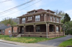 | May-Latta House | 0.1 miles | 1989 |
 | B. F. Combs House | 0.2 miles | 1989 |
 | Front Street Historic District | 0.2 miles | 1989 |
 | Methodist Episcopal Church, South | 0.2 miles | 1989 |
| National Archives record | The nomination case file for reference 89000417 in Record Group 79. |
| Floyd County | All 15 listed properties in this county. |