 Block
From the record
One of 6 National Register listings published here for Monroe County · listed in 1992 · category: Building.
Sources: the case file at the National Archives · the National Register database, National Park Service

Listed on the National Register of Historic Places in 1992.
One of 6 National Register listings published here for Monroe County · listed in 1992 · category: Building.
Sources: the case file at the National Archives · the National Register database, National Park Service
Regional context, not property-specific evidence. The federal wildfire occurrence database lists 50 fires within 5 miles of Thomas P. Evans House between 1999 and 2017, burning about 450 acres in total. 1 started naturally. 2 were recorded as arson. Distance is straight-line from the map coordinates, so a fire counted here may appear on a neighbouring settlement's page as well.
| Reported cause | Fires |
|---|---|
| Missing data/not specified/undetermined | 18 |
| Debris and open burning | 13 |
| Recreation and ceremony | 11 |
| Railroad operations and maintenance | 4 |
| Arson/incendiarism | 2 |
| Natural | 1 |
| Smoking | 1 |
The most recent of them, most recent first, with the day each was reported and the service that recorded it.
| Date | Cause | Size | Reported by | Name on the report |
|---|---|---|---|---|
| 26 September 2008 | Debris and open burning | 8.0 acres | Kentucky Division of Forestry | not named |
| 3 August 2011 | Natural | 6.0 acres | Kentucky Division of Forestry | FACTORY |
| 25 June 2005 | Missing data/not specified/undetermined | under an acre | Kentucky Division of Forestry | not named |
| 5 April 2006 | Missing data/not specified/undetermined | 7.0 acres | Kentucky Division of Forestry | not named |
| 24 April 2009 | Recreation and ceremony | 6.0 acres | Kentucky Division of Forestry | not named |
| 22 April 2007 | Recreation and ceremony | 2.0 acres | Kentucky Division of Forestry | not named |
| 2 April 2010 | Debris and open burning | 71 acres | Kentucky Division of Forestry | not named |
| 2 April 2010 | Debris and open burning | 9.0 acres | Kentucky Division of Forestry | not named |
Regional context, not property-specific evidence. The federal mineral resources record lists 1 working within 5 miles of Thomas P. Evans House: 1 producer. All of them still produce. What was taken out: Stone, Crushed/Broken. Distance is straight-line from the map coordinates, so a quarry counted here may appear on a neighbouring settlement's page as well.
| Where | Site | Commodity | Status | Recorded |
|---|---|---|---|---|
| Trico Stone Mine | Stone, Crushed/Broken | Producer |
Regional context, not property-specific evidence. The National Weather Service names Tompkinsville, the town this property stands in, in 41 storm reports between 2000 and 2024: 25 thunderstorm wind, 9 hail, 4 flash flood, 2 tornado. No death or injury is recorded in these reports. Each account below is quoted exactly as the forecast office filed it, from the NOAA Storm Events Database, and each date opens the federal record of that event.
| When | Event | Place named | Harm | What the report says |
|---|---|---|---|---|
| May 2010 | Flash Flood | Tompkinsville | $100,000 | Numerous roads across the county were closed due to flash flooding. A total of six to ten inches of rain fell across Monroe county from May 1-2. |
| July 2016 | Thunderstorm Wind | Tompkinsville | $25,000 | Local law enforcement reported trees and power lines down across the county. |
| June 2019 | Thunderstorm Wind | Tompkinsville | $20,000 | Multiple trees and power lines were reported down. |
| July 2010 | Lightning | Tompkinsville | $10,000 | Lightning sparked a house fire on Sixth Street. The time is approximate. |
| May 2010 | Tornado (EF0) | Tompkinsville | $5,000 | A NWS storm survey confirmed that a tornado touched down around 835 am CDT 4.3 miles west of Tompkinsville. A tobacco barn and several trees were damaged. The tornado then traveled east around 5.7 miles and lifted 1.4 miles east of Tompkinsville after damaging several trees. The tornado was rated EF-0 with estimated winds of 80 to 85 mph. |
| May 2003 | Thunderstorm Wind | Tompkinsville | $2,000 | A window was blown out of a house. Trees were blown down across city streets. |
| May 2024 | Thunderstorm Wind | Tompkinsville | - | Trees were downed in Tompkinsville as well as across Monroe County. |
| July 2022 | Thunderstorm Wind | Tompkinsville | - | Power lines were reported down on the west side of Tompkinsville. |
| February 2021 | Flash Flood | Tompkinsville | - | Water was over Watt Bridge on Kentucky 163. |
| May 2021 | Tornado (EF1) | Tompkinsville | - | The National Weather Service determined an EF-1 tornado with maximum sustained winds of 95 mph caused a damage path 60 yards wide. ||The thunderstorm quickly became severe in southwest Monroe County. It quickly became severe in southwest Monroe County and became tornadic on the southwest side of Tompkinsville. The tornado touched down near the intersection of Second and Jackson Streets. Trees were lying in multiple directions and most of them were twisted, snapped, or uprooted. Power lines were down, and several power poles were snapped. Winds at that location were between 85 and 90 mph with a width of 50 yards. ||Farther to the northeast, between 5th Street and Carter Street, the tornado increased to 95 mph and the width expanded out to 60 yards. Several homes experienced roof damage with some windows blown out. One home had multiple large trees uprooted with a camper trailer and pontoon boat flipped over. There were several pieces of lumber that were impaled in the ground and pieces of sheet metal thrown into trees. ||The US Bank building received roof damage before the tornado briefly lifted before touching down near the intersection of Pedigo and White Streets. ||There was significant tree damage on the east of Main Street by Pedigo Street. Trees were facing multiple directions. Mud spatter was on the backside of homes and vehicles along Short Street to Monroe Street. Multiple power lines were down in the area. Winds decreased to 90 mph along Monroe Street. ||The National Weather Service drone found some twisted tree tops near Spring Valley Road and Woodhaven as a result of wind speeds of 85 mph. The tornado lifted at Jackie Crow Salvage Yard as it threw debris on top of a hill about 250 yards from the salvage yard. ||Several videos showed brief funnels coming down from the main storm, almost like a small skipping tornado. |
| January 2020 | Thunderstorm Wind | Tompkinsville | - | Broadcast media relayed a public picture of severe roof damage to a home near Tompkinsville. |
| July 2018 | Hail | Tompkinsville | - | A verified photo on social media showed these large hail stones. |
| August 2018 | Flash Flood | Tompkinsville | - | Water was reported flowing over the roadway on Highway 100 East. The road was impassable. |
| July 2015 | Hail | Tompkinsville | - | A trained spotter reported hail between 3 and 3.5 inches in diameter, confirmed by a social media photo relayed to the NWS. |
| July 2015 | Hail | Tompkinsville | - | A trained spotter reported hail 1.75 inches in diameter. The spotter also noted that the severe thunderstorm brought high winds and heavy rainfall. |
| July 2015 | Hail | Tompkinsville | - | A public report was received of hail 2.75 inches in diameter. |
| July 2012 | Thunderstorm Wind | Tompkinsville | - | A downburst traveling north felled several trees in and around Tompkinsville. |
| March 2011 | Hail | Tompkinsville | - | A trained spotter reported pea to quarter sized hail. |
| April 2011 | Thunderstorm Wind | Tompkinsville | - | A roof of a house was significantly damaged on Capp Harlan Rd. A CMV trailer was also blown over on its side and several trees were blown down. |
| April 2011 | Thunderstorm Wind | Tompkinsville | - | Trees were reported down countywide. Widespread damage to homes was reported and a tractor trailer was blown over. |
| March 2011 | Hail | Tompkinsville | - | A trained spotter reported hail just under golf ball size. |
| April 2011 | Thunderstorm Wind | Tompkinsville | - | Trees were blown down near Center Point Rd. |
| August 2010 | Thunderstorm Wind | Tompkinsville | - | Trees and power lines were blown down all over Tompkinsville. |
| April 2009 | Thunderstorm Wind | Tompkinsville | - | Trees were downed near Tompkinsville. |
| February 2009 | Thunderstorm Wind | Tompkinsville | - | Several large trees were uprooted, one of which fell on a home. A few other homes received damage. |
| June 2009 | Thunderstorm Wind | Tompkinsville | - | Trees were downed in Tompkinsville. |
| January 2008 | Thunderstorm Wind | Tompkinsville | - | Thunderstorm winds downed trees and blew a dumpster across a road. |
| April 2008 | Thunderstorm Wind | Tompkinsville | - | Trees were downed on Vernon Road and Heston. |
| May 2006 | Thunderstorm Wind | Tompkinsville | - | Law enforcement personnel estimated a 60 mph wind gust. |
| April 2006 | Thunderstorm Wind | Tompkinsville | - | Trees were downed. |
| November 2002 | Thunderstorm Wind | Tompkinsville | - | Power lines were downed. |
| March 2002 | Flash Flood | Tompkinsville | - | State Road 163 south of Tompkinsville had 8 to 10 inches of water over the roadway. |
| May 2000 | Thunderstorm Wind | Tompkinsville | - | Numerous trees were downed across the southern part of the county. |
| July 2018 | Hail | Tompkinsville | - | no account filed |
| July 2007 | Thunderstorm Wind | Tompkinsville | - | no account filed |
| May 2006 | Hail | Tompkinsville | - | no account filed |
| July 2005 | Thunderstorm Wind | Tompkinsville | - | no account filed |
| July 2005 | Thunderstorm Wind | Tompkinsville | - | no account filed |
| November 2002 | Hail | Tompkinsville | - | no account filed |
| October 2001 | Thunderstorm Wind | Tompkinsville | - | no account filed |
| October 2001 | Thunderstorm Wind | Tompkinsville | - | no account filed |
No historic map-sheet match is published for this property yet. That does not mean no map exists. This record needs a coordinate-quality review before it can be joined to a sheet boundary. Browse the county's mapped places while that work is pending.
Other National Register properties close enough to walk or drive between, ordered by distance from this one. Both positions come from the same geocoding pass that matched these properties to their map sheets.
| Photograph | Property | Distance | Listed |
|---|---|---|---|
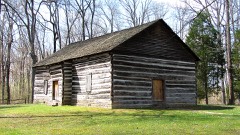 | Old Mulkey Meetinghouse | 1.9 miles | 1973 |
| Barlow Baxter House | 4.9 miles | 2001 | |
 | Mount Vernon A.M.E. Church | 6.2 miles | 1977 |
| National Archives record | The nomination case file for reference 92001488 in Record Group 79. |
| Monroe County | All 6 listed properties in this county. |