
BlockBefore
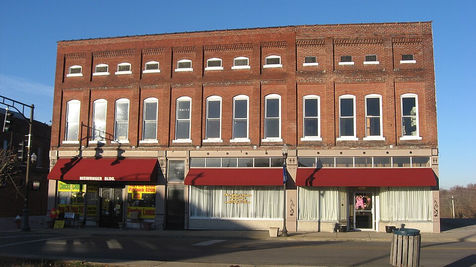
Photograph of Providence Commercial Historic District
Photograph by Nyttend, Public domain. Via Wikimedia Commons.

Providence Commercial Historic District

Listed on the National Register of Historic Places in 1993.

From the record

“The Providence Commercial Historic District, in Providence, Kentucky, is a historic district which was listed on the National Register of Historic Places in 1993. It includes 25 contributing buildings and four non-contributing ones, along the 100-200 blocks on East and West Main and on North and South Broadway in downtown Providence.”

Wikipedia article Providence Commercial Historic District, CC BY-SA 4.0.

One of 3 National Register listings published here for Webster County · listed in 1993 · category: District.

Sources: the Wikipedia article · the case file at the National Archives · the National Register database, National Park Service

The listing

  • What is counted as historic. The nomination lists 25 buildingss as contributing to the listing.
  • Address. 100--200 blks. on E. and W. Main and N. and S. Broadway, Providence, 42450
  • When was it listed? March 1993
  • Category. district
  • Census division. Providence
  • National Register reference number. 93000042 - the number the National Park Service assigned this property when it was listed, and the key its nomination file is catalogued under at the National Archives.

Fires near this property

29 since 1998

Regional context, not property-specific evidence. The federal wildfire occurrence database lists 29 fires within 5 miles of Providence Commercial Historic District between 1998 and 2014, burning about 1,104 acres in total. None started naturally. 8 were recorded as arson. Distance is straight-line from the map coordinates, so a fire counted here may appear on a neighbouring settlement's page as well.

Reported cause Fires
Missing data/not specified/undetermined10
Arson/incendiarism8
Debris and open burning6
Railroad operations and maintenance2
Equipment and vehicle use1
Recreation and ceremony1
Misuse of fire by a minor1

The most recent of them, most recent first, with the day each was reported and the service that recorded it.

DateCause SizeReported by Name on the report
24 June 2012Debris and open burning122 acresKentucky Division of ForestryPLASTIC FI
20 June 2012Railroad operations and maintenanceunder an acreKentucky Division of ForestryJUNKYARD F
28 April 2001Arson/incendiarism5.0 acresKentucky Division of Forestrynot named
19 April 2001Debris and open burningunder an acreKentucky Division of Forestrynot named
7 March 2010Debris and open burning30 acresKentucky Division of Forestrynot named
7 March 2000Railroad operations and maintenance150 acresKentucky Division of Forestrynot named
6 March 2000Arson/incendiarism100 acresKentucky Division of Forestrynot named
28 March 2004Missing data/not specified/undetermined40 acresKentucky Division of Forestrynot named

Every fire recorded in Webster County

Storms near this property

34 since 1996

Regional context, not property-specific evidence. The National Weather Service names Providence, the town this property stands in, in 34 storm reports between 1996 and 2023: 10 thunderstorm wind, 10 hail, 5 flash flood, 4 flood. The reports record 26 injuries. Each account below is quoted exactly as the forecast office filed it, from the NOAA Storm Events Database, and each date opens the federal record of that event.

WhenEvent Place namedHarm What the report says
April 2002Tornado (F3)Providence26 hurt, $15,000,000The tornado crossed southern Webster County, producing major damage as it paralleled Highway 120 through Providence. About two dozen persons were injured, and they were transported by ambulance to regional hospitals. One person was critically injured. The tornado produced F-3 damage in Providence, then weakened to an F-2 tornado just east of the city limits. The tornado struck a mobile home park in Providence, destroying 16 of the 20 mobile homes there. About 10 permanent homes were destroyed, and about 100 more homes were damaged.
November 2017Thunderstorm WindProvidence$450,000A microburst with estimated wind speeds near 75 mph downed hundreds of trees and limbs in and near Providence. Numerous trees were snapped or uprooted. The damage path was approximately 1.25 miles long across the community of Providence. At least 50 homes sustained partial shingle loss or structural damage. A porch was blown off one home. A wall was blown out of a barn. Garage doors were blown in at a residence. Widespread damage was observed across town. Numerous power lines were down, and the entire community of Providence was without power.
May 2004Tornado (F1)Providence$150,000Around 30 homes were damaged by this tornado that tracked across the southern and eastern fringe of Providence. Several homes received major damage, in excess of ten thousand dollars each. About a dozen homes were moderately damaged, and the rest had minor damage. On Highway 120, a delivery truck was pushed over onto a car. Twelve utility poles were replaced. Much of the damage was caused by fallen trees. Peak winds in this tornado were estimated near 100 MPH.
May 1996Thunderstorm WindProvidence$50,000no account filed
June 2019Thunderstorm WindProvidence$30,000A microburst snapped numerous large tree limbs and uprooted a few trees as it moved east through Providence. Large trees and power lines were down, including trees on houses. In particular, numerous trees were down in the Baptist Hill area on the west side of town.
January 2013Flash FloodProvidence$20,000Emergency management officials reported multiple state roads closed due to flooding. Two individuals were rescued from the top of a flooded vehicle.
April 2011Thunderstorm WindProvidence$20,000In Clay, several trees were blown down. One of the trees fell on a car. Carports and fences were damaged on Kentucky Highway 132. In Providence, several tree limbs and power lines were down.
June 2022Thunderstorm WindProvidence$10,000Lots of large tree limbs and power lines were blown down throughout town.
May 2016HailProvidence$10,000no account filed
May 2017Thunderstorm WindProvidence$3,000Tree limbs were blown down on Highway 41-A in Providence and Dixon, as well as Highway 109 in Diamond. Power outages affected a large portion of Providence.
May 2006Thunderstorm WindProvidence$3,000Six trees and two power lines were blown down.
March 2023Flash FloodProvidence-Several state roads were closed due to high water in Webster County, including Highways 132, 270, 138, and 2836. A few other state roads were open but covered with water. Some county roads were also affected by flooding.
March 2023FloodProvidence-A few state roads were closed by high water, including Highways 132, 138, and 270. Four other state roads were open but high water signs were placed on them. The flooding was from rain the previous day.
June 2019Flash FloodProvidence-Highways 120 and 670 were closed by flash flooding. Highway 120 was closed east of Providence, and Highway 670 was closed near the Dotiki mine site. The public reported up to two inches of rain fell in 20 minutes.
March 2015FloodProvidence-Numerous roads were flooded and closed.
August 2015Heavy RainProvidence-The 24-hour total rainfall was 2.70 inches, which fell almost entirely in a six-hour window during the late night and early morning hours.
December 2015Heavy RainProvidence-Street flooding was reported in Providence. Other locations with water over the road included the Sebree area along Highway 132 West and Highway 857 between Clay and Dixon.
June 2014Heavy RainProvidence-A co-operative observer measured 4.03 inches of rain in 24 hours. Most of the rain fell during thunderstorms on the evening of the 4th.
December 2011FloodProvidence-Street flooding was widespread in downtown Slaughters.
April 2008FloodProvidence-Countywide, many roads were covered with water. Some roads were closed, including Highway 132 between Clay and Dixon.
July 2004Thunderstorm WindProvidence-A spotter estimated wind gusts from 50 to 60 MPH. A tree fell across U.S. Highway 41-A.
May 2003Thunderstorm WindProvidence-The road department cleared a few trees that fell across roads in Providence.
October 2001Thunderstorm WindProvidence-A few trees were blown down.
June 2023HailProvidence-no account filed
December 2015HailProvidence-no account filed
February 2012HailProvidence-no account filed
April 2011HailProvidence-no account filed
June 2011HailProvidence-no account filed
May 2004HailProvidence-no account filed
July 2004HailProvidence-no account filed
May 2003HailProvidence-no account filed
May 1998HailProvidence-no account filed
March 1997Flash FloodProvidence-no account filed
April 1996Flash FloodProvidence-no account filed

Every storm recorded in Webster County

Map coverage status

No historic map-sheet match is published for this property yet. That does not mean no map exists. This record needs a coordinate-quality review before it can be joined to a sheet boundary. Browse the county's mapped places while that work is pending.

Sources for this property

National Archives recordThe nomination case file for reference 93000042 in Record Group 79.
Wikipedia articleCommunity-written account of this property, licensed CC BY-SA.
Webster CountyAll 3 listed properties in this county.

Provenance

  • Listing record. National Park Service National Register of Historic Places, listed-properties dataset, current to 2026-05-22.
  • Map join. Address geocoded through the United States Census geocoder, then tested against the published boundary of every sheet in the USGS Historical Topographic Map Collection.
  • How this page is made. Listing fields come from federal records; map-sheet coverage is a labelled coordinate-to-boundary calculation, not a source-field claim.
  • Wildfire. Short, Karen C. 2022. Spatial wildfire occurrence data for the United States, 1992-2020 [FPA_FOD_20221014]. 6th Edition. Fort Collins, CO: Forest Service Research Data Archive. https://doi.org/10.2737/RDS-2013-0009.6 Collected with United States Government funding and usable without additional permissions or fees.
  • Storms. NOAA National Centers for Environmental Information, Storm Events Database https://www.ncei.noaa.gov/stormevents/ A work of the United States government, no copyright under 17 U.S.C. 105. Narratives are quoted verbatim from the National Weather Service report and are not edited or summarised.