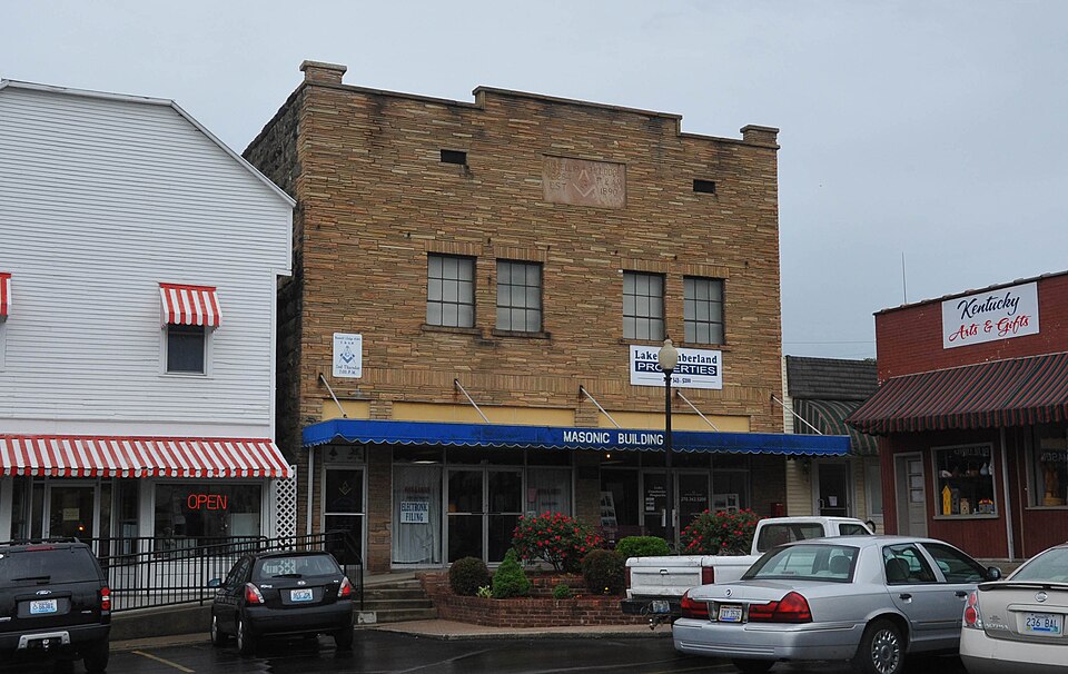
Built in 1939. Listed on the National Register of Historic Places in 1994.
From the record
“The Russell Lodge No. 284, also known as the Jamestown Masonic Lodge, on Public Square in Jamestown, Kentucky, is a Masonic Hall which was built in 1939. It was listed on the National Register of Historic Places in 1994.”
Wikipedia article Russell Lodge No. 284, CC BY-SA 4.0.
One of 2 National Register listings published here for Russell County · listed in 1994 · category: Building · built in 1939.
National Register reference number.93001586- the number the National Park Service assigned this property when it was listed, and the key its nomination file is catalogued under at the National Archives.
Fires near this property
8 since 1998
Regional context, not property-specific
evidence. The
federal wildfire occurrence database
lists 8 fires within 5 miles of Russell Lodge No. 284
between 1998 and 2020, burning about 261 acres in total. None started naturally. 1 was recorded as arson.
Distance is straight-line from the map coordinates, so a fire counted
here may appear on a neighbouring settlement's page as well.
Reported cause
Fires
Missing data/not specified/undetermined
3
Debris and open burning
2
Smoking
1
Arson/incendiarism
1
Equipment and vehicle use
1
The most recent of
them, most recent first, with the day each was reported and the service
that recorded it.
Regional context, not property-specific
evidence. The federal mineral resources record lists
1 working within 5 miles of Russell Lodge No. 284: 1 past producer.
None of them still produces. What was taken out: Sand and Gravel, Construction. Distance is straight-line from the
map coordinates, so a quarry counted here may appear on a neighbouring
settlement's page as well.
Regional context, not property-specific
evidence. The National Weather Service names
Jamestown, the town this property stands in, in 38 storm reports between 1997 and 2023: 26 thunderstorm wind, 7 hail, 2 tornado, 2 flash flood.
No death or injury is recorded in these reports. Each account below is quoted exactly as the forecast office
filed it, from the NOAA Storm Events Database, and each date
opens the federal record of that event.
Boat storage structures were damaged near Jamestown. Outbuildings and barns were damaged. A tree was blown on to a mobile home. Numerous trees were down along Highway 379.
A tornado touched down just east of US 127, north of Woolen Mill Road, in an area of mostly open fields with patches of trees along fence rows. Damage could be seen in the tree tops lowering until reaching the ground. The tornado moved eastward towards |West Cumberland Avenue in western Jamestown. While plowing through clusters of trees, tree damage was highly focused with many mature healthy trees being snapped. As the tornado approached a set of apartment buildings on the 1100 block of West Cumberland Avenue, views from an aerial drone showed heavy tree damage with trees falling in several directions. A roof from one of the buildings blew off to a southwest direction. A large window from across the street at the auto museum got sucked out and ended up in the roadway. To the north, large sections of the roof at Jamestown Auto Sales got peeled back from the northwest to the southeast. ||The main tornado track continued east while a small suction vortex fed into the main rotation near Telephone Drive. Along Telephone Drive, a large tree was uprooted and fell to the southeast while two well built buildings had their gable porch roofs blown to the north. One remained attached to the roof while the other was blown to the northeast over the building, coming to rest behind C&W Auto Parts which had its own |southeast facing window blown out. All three of these buildings had mud splattered on their southeast facing exterior wall. ||Farther east in the main tornado track, the tornado damaged a large area of the Carpet Center's roof. Just to the south, a single family home had half of its roof blown off. To the north and east of the Carpet Center, the strongest damage was done at a residence. A garage made out of cinder blocks was completely leveled by 110 mph winds on two sides while the other two sides saw nothing remain above the windows. Every tree in the area was severely damaged. Multiple trees fell on the house and the |owners vehicles. A limb of a tree punched through the wall and was in the house. Multiple large trees continued to get uprooted as the tornado traveled eastward before lifting near Brown Road.
A very pronounced bowing segment cut southeast across Russell County during the early morning hours on Monday. This area of surging wind caused widespread tree damage in the Jamestown area.||The survey team focused on areas with the heaviest damage which were all south of Jamestown. The first area of considerable damage was at Jamestown Boat Storage on the west side of State Road 92. One of their large multi bay buildings had 5 southwest |facing oversized garage doors damaged. This allowed wind to get into the structure causing parts of the roof to collapse and other parts to blow off. The southeast wall sheet metal was also blown out. Half of the roof was completely gone over 9 bays, and |on the northeast side of the building the whole roof was down over 5 bays. Another storage building, to the southeast, on the same property had a few damaged garage doors and a small area of roof damage above the doors. ||Less than a mile farther south on State Road 92, Stripers Boat Storage had 4 northwest facing garage doors blown in and damaged. Wind that made it into the building blew out 2 southeast facing doors. On the southwest side of the building, there were a couple snapped and uprooted mature trees facing to the southeast. Across the road on Lily Creek Ramp Road, Cumberland Boat Storage had at least 9 bays of their western most building completely destroyed. Wind blew in the doors on the northwest side of the building before blowing off the roof structure and walls. Nothing was left standing on the southwest side of the building. ||A little farther south, a concentrated area of tree damage stretched along a southwest to northeast axis which was along area ridge tops. Along these ridges many roads including Oak Road, Carriage Lane, Pumpkin Creek Road, Harbor Springs and a few |others there were hundreds of large mature trees that were snapped and uprooted, many of which brought down area power lines and poles. Many trees fell on houses causing major damage. A few houses on Pumpkin Creek Road were completely destroyed due to multiple trees falling on them. All the downed trees in the area |fell to the southeast. No definitive convergence was observed.||The last of the damage was observed just under a mile farther south on Harbor Springs Road. Large uprooted trees were a common sight. This brought down power lines and poles, but the damage wasn't nearly as concentrated as that along Pumpkin Creek Road.
A stated official reported that two inches of water was over Highway 619. The water was from Lily Creek and continued to rise during the time reported.
No historic map-sheet match is published
for this property yet. That does not mean no map exists. This record needs
a coordinate-quality review before it can be joined to a sheet boundary.
Browse the county's mapped places while that work is
pending.
Listed places nearby
1 within 8 miles
Other National Register properties close
enough to walk or drive between, ordered by distance from this one. Both
positions come from the same geocoding pass that matched these properties
to their map sheets.
Listing record. National Park Service National Register of Historic Places, listed-properties dataset, current to 2026-05-22.
Map join. Address geocoded through the United States Census geocoder, then tested against the published boundary of every sheet in the USGS Historical Topographic Map Collection.
How this page is made. Listing fields come from federal records; map-sheet coverage is a labelled coordinate-to-boundary calculation, not a source-field claim.
Wildfire. Short, Karen C. 2022. Spatial wildfire occurrence data for the United States, 1992-2020 [FPA_FOD_20221014]. 6th Edition. Fort Collins, CO: Forest Service Research Data Archive. https://doi.org/10.2737/RDS-2013-0009.6 Collected with United States Government funding and usable without additional permissions or fees.
Mines and quarries. USGS Mineral Resources Data System (MRDS) https://mrdata.usgs.gov/mrds/ A work of the United States government, no copyright under 17 U.S.C. 105.
Storms. NOAA National Centers for Environmental Information, Storm Events Database https://www.ncei.noaa.gov/stormevents/ A work of the United States government, no copyright under 17 U.S.C. 105. Narratives are quoted verbatim from the National Weather Service report and are not edited or summarised.
 Block