 Block
From the record
One of 11 National Register listings published here for Caldwell County · listed in 1995 · category: Building.
Sources: the case file at the National Archives · the National Register database, National Park Service
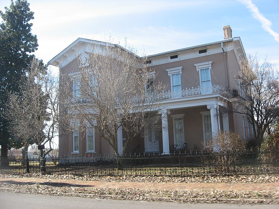
Listed on the National Register of Historic Places in 1995.
One of 11 National Register listings published here for Caldwell County · listed in 1995 · category: Building.
Sources: the case file at the National Archives · the National Register database, National Park Service
Regional context, not property-specific evidence. The federal wildfire occurrence database lists 22 fires within 5 miles of William S. Powell House between 1997 and 2019, burning about 45 acres in total. None started naturally. 1 was recorded as arson. Distance is straight-line from the map coordinates, so a fire counted here may appear on a neighbouring settlement's page as well.
| Reported cause | Fires |
|---|---|
| Recreation and ceremony | 9 |
| Missing data/not specified/undetermined | 5 |
| Railroad operations and maintenance | 4 |
| Debris and open burning | 2 |
| Smoking | 1 |
| Arson/incendiarism | 1 |
The most recent of them, most recent first, with the day each was reported and the service that recorded it.
| Date | Cause | Size | Reported by | Name on the report |
|---|---|---|---|---|
| 29 September 2010 | Recreation and ceremony | 1.0 acres | Kentucky Division of Forestry | GRAVES FIRE |
| 25 September 2015 | Recreation and ceremony | 1.0 acres | Kentucky Division of Forestry | DAWSON ROAD |
| 20 September 2004 | Missing data/not specified/undetermined | 3.0 acres | Kentucky Division of Forestry | not named |
| 13 September 2002 | Recreation and ceremony | 1.0 acres | Kentucky Division of Forestry | not named |
| 9 August 2004 | Missing data/not specified/undetermined | 1.0 acres | Kentucky Division of Forestry | not named |
| 4 August 1997 | Railroad operations and maintenance | 1.0 acres | Kentucky Division of Forestry | not named |
| 4 August 1997 | Railroad operations and maintenance | 3.0 acres | Kentucky Division of Forestry | not named |
| 24 July 2012 | Debris and open burning | under an acre | Kentucky Division of Forestry | BOTTLE RO |
Regional context, not property-specific evidence. The federal mineral resources record lists 11 workings within 5 miles of William S. Powell House: 5 past producers, 2 occurrences, 2 producers, 2 prospects. 2 still produce. What was taken out: Fluorine-Fluorite, Stone, Crushed/Broken, Silica, Cobalt, Manganese, Nickel, Iron. Distance is straight-line from the map coordinates, so a quarry counted here may appear on a neighbouring settlement's page as well.
| Where | Site | Commodity | Status | Recorded |
|---|---|---|---|---|
| Hobby Titanium Deposit | Titanium | Occurrence | ||
| Jesse Redd Prospect | Cobalt, Manganese, Nickel, Iron | Occurrence | 1904 | |
| Phelps Sandstone Pit | Silica | Past Producer | ||
| Princeton Mine | Stone, Crushed/Broken | Producer | ||
| Princeton No. 2 Mine | Stone, Crushed/Broken | Producer | ||
| Princeton Sandstone Pit | Silica | Prospect | ||
| Bright Mine | Fluorine-Fluorite | Past Producer | ||
| Morgan Heirs Fluorspar Tract | Fluorine-Fluorite | Prospect | ||
| Senator Main Shaft | Fluorine-Fluorite | Past Producer | ||
| Senator No.1 Shaft | Fluorine-Fluorite | Past Producer |
Regional context, not property-specific evidence. The National Weather Service names Princeton, the town this property stands in, in 70 storm reports between 1993 and 2025: 29 thunderstorm wind, 19 hail, 9 flash flood, 4 flood. No death or injury is recorded in these reports. Each account below is quoted exactly as the forecast office filed it, from the NOAA Storm Events Database, and each date opens the federal record of that event.
| When | Event | Place named | Harm | What the report says |
|---|---|---|---|---|
| November 2013 | Tornado (EF1) | Princeton | $200,000 | A large metal building sustained partial loss of the roof and a wall. Several power poles were snapped. The porch was lifted up from the front of a house. Several homes and businesses sustained partial shingle loss. Dozens of trees were snapped or uprooted. The Western Kentucky Parkway was shut down in Princeton after a large power transmission line fell onto the roadway near a sub-station. Peak winds were estimated near 100 mph. The maximum intensity of the tornado was at the Western Kentucky Parkway interchange with Kentucky Route 91 in Princeton. |
| April 2008 | Flood | Princeton | $100,000 | Seven state highways were covered by water, including U.S. Highway 641 near the Lyon County line. State Route 139 was covered with water north of Princeton near the 14 mile marker. A bridge was washed out on a secondary road near Creswell. Other less travelled roads across the county were covered. |
| August 2005 | Flash Flood | Princeton | $100,000 | Much of Princeton was underwater after local residents reported five to six inches of rainfall in less than two hours. Yards and streets were left flooded and impassable. In one of the hardest hit neighborhoods, waist-deep water kept a street closed for hours after the rain stopped. About a dozen streets, including some main arteries such as Kentucky 91, were closed. A number of vehicles stalled in the flooding. City workers helped stranded motorists out of the flooding. Several buildings sustained flood damage, which was aggravated by waves in the wake of passing vehicles. About 18 inches of water backed up into a laundromat. Three to four inches of water covered a factory warehouse floor, causing an estimated 10,000 dollars in damage. Water entered fewer than a dozen houses, mostly flooding basements. In one house, the basement filled up, and water spilled onto the first floor. At the local electric plant, floodwater from Eddy Creek was chest-deep in the plant's storage yard, and water entered garages where trucks are parked. At the city's hospital, a basement filled with water, which was pumped out by the fire department. The flooding was described by an emergency management director as the city's worst flooding in 18 years. |
| March 1997 | Flash Flood | Princeton | $100,000 | no account filed |
| July 2015 | Thunderstorm Wind | Princeton | $50,000 | A microburst with peak winds estimated near 80 mph raked parts of Caldwell County. Dozens of tree limbs and at least a dozen trees were blown down. Power lines were downed by a fallen tree. The roof of a farm shed was blown off. Two windows were blown out of a storefront in downtown Princeton. Several small signs were blown down. The path of the microburst began along Highway 91 northwest of Princeton. The path extended southeastward across the city of Princeton, reaching a maximum width of 4000 yards. The path length was just over 9 miles. |
| October 2004 | Tornado (F1) | Princeton | $50,000 | A residence on Fairview Church Road sustained major damage when it was struck by a large tree. There was severe roof damage, and much of the home's interior was damaged. Part of the ceiling collapsed, and the foundation was cracked. Other large trees landed across the driveway and demolished a fence. At a neighboring house, the wind bent a TV antenna and downed multiple trees. A swing set at another neighboring house was crushed by a large tree limb. Maximum winds in the tornado were estimated near 80 MPH. |
| September 2001 | Thunderstorm Wind | Princeton | $50,000 | Eight roofs were blown off buildings. One trailer home used for storage was demolished. Three power poles were snapped. Railroad crossing arms were broken off, and many vehicles were damaged. |
| January 2002 | Thunderstorm Wind | Princeton | $40,000 | Five residences, two barns, and other outbuildings were damaged. One home lost part of its roof and the entire back porch, which was blown onto the highway. Most of the damage was in the vicinity of Kentucky 293 and Briarfield Road. |
| July 2016 | Flash Flood | Princeton | $30,000 | Several feet of flowing water covered portions of parking lots and ball fields along Highway 139 near Princeton. A portion of a secondary road was impassable near Creswell. Near the Trigg County line, flash flooding of a creek known as Long Pond Branch washed out a section of Highway 276. This was the same site where a vehicle fatality occurred in July of 2015. At that time, the road was washed out beneath the vehicle. The vehicle was then carried over 300 yards into Trigg County by the rushing floodwaters. Temporary repairs were made after that incident, however the road was washed out again in the same spot during this storm. |
| July 2023 | Thunderstorm Wind | Princeton | $25,000 | A wind gust to 58 mph was recorded at the Kentucky mesonet site near Princeton. There were multiple reports of trees down in Princeton. Trees were down over Highway 903 four miles south-southwest of Princeton. |
| October 1996 | Flood | Princeton | $25,000 | no account filed |
| August 2010 | Thunderstorm Wind | Princeton | $10,000 | A microburst demolished a wood barn. |
| January 2008 | Thunderstorm Wind | Princeton | $10,000 | Trees were blown down in the city and surrounding county roads. Some bricks were blown off buildings. |
| March 2006 | Thunderstorm Wind | Princeton | $6,000 | Barns were blown down in Princeton. Several trees were blown across power lines in Fryer. |
| March 2017 | Thunderstorm Wind | Princeton | $5,000 | A wind gust to 77 mph was measured at a Kentucky mesonet site. Trees were damaged, including at least one uprooted tree in Princeton. |
| June 2004 | Thunderstorm Wind | Princeton | $5,000 | A large tree fell on a vehicle. Large tree limbs were down also. |
| May 1999 | Thunderstorm Wind | Princeton | $5,000 | Power lines and a few trees were down. |
| July 1997 | Thunderstorm Wind | Princeton | $5,000 | Trees were down over power lines. |
| January 1999 | Thunderstorm Wind | Princeton | $4,000 | About a dozen trees were blown down across Caldwell County. |
| August 2015 | Flash Flood | Princeton | $3,000 | Water was over Kentucky Highway 91 in several places between the 17 and 21 mile markers. At one location, water was reported to be a foot deep with strong current. Brush and tree limbs swept along by the floodwaters clogged a culvert near the community of Crider. |
| May 2007 | Thunderstorm Wind | Princeton | $3,000 | A few downed trees blocked roads, mainly in north and east portions of the county. |
| June 1999 | Thunderstorm Wind | Princeton | $3,000 | Trees and power lines were down. |
| April 2003 | Thunderstorm Wind | Princeton | $3,000 | no account filed |
| May 2025 | Hail | Princeton | - | Ping pong ball size hail was measured in Princeton. |
| May 2025 | Thunderstorm Wind | Princeton | - | Max wind gust from Kentucky Mesonet station PRNC (2SE Princeton) over the five minute period. |
| May 2024 | Hail | Princeton | - | Hail was reported near Princeton as a thunderstorm progressed eastward, with penny size hail near the Princeton Golf Club and quarter size hail on the south side of Princeton. A 56 mph wind gust was observed at the Mesonet station PRNC Princeton KY 2 SE. |
| August 2023 | Flash Flood | Princeton | - | Several roads were flooded in Princeton. |
| July 2023 | Flash Flood | Princeton | - | Numerous streets were flooded throughout Princeton. Radar estimates indicated around two inches fell in 45 minutes. |
| July 2023 | Thunderstorm Wind | Princeton | - | The mesonet site near Princeton measured a wind gust to 60 mph. |
| April 2022 | Thunderstorm Wind | Princeton | - | Trees were bent over at several locations south-southeast of Princeton. |
| February 2018 | Hail | Princeton | - | Nickel-size hail was reported on Highway 672. |
| April 2018 | Funnel Cloud | Princeton | - | The funnel cloud was observed just off U.S. Highway 62 by numerous individuals. |
| December 2018 | Flood | Princeton | - | Kentucky Highway 139 South was closed due to floodwaters at the 7 to 8 mile markers. Kentucky Highway 91 North was closed at the 19 mile marker. |
| July 2016 | Thunderstorm Wind | Princeton | - | A trained spotter measured a wind gust to 65 mph. |
| July 2016 | Thunderstorm Wind | Princeton | - | A trained spotter measured a wind gust to 64 mph in Princeton. Trees were bent over several miles north of Princeton along Highway 293. |
| August 2014 | Heavy Rain | Princeton | - | A Kentucky mesonet site measured 3.29 inches of rain in a couple of hours. |
| November 2013 | Thunderstorm Wind | Princeton | - | A wind gust to 63 mph was measured at the Kentucky mesonet site. |
| January 2013 | Thunderstorm Wind | Princeton | - | A wind gust to 74 mph was measured at the mesonet site near Princeton. |
| June 2010 | Funnel Cloud | Princeton | - | A funnel cloud was sighted by a trained spotter along Kentucky Highway 139 in southern Princeton. |
| August 2009 | Heavy Rain | Princeton | - | Several roads were impassable due to water over them. |
| April 2007 | Flash Flood | Princeton | - | Numerous streets were experiencing minor flooding. |
| June 2006 | Thunderstorm Wind | Princeton | - | Numerous trees were blown down, with eight streets briefly blocked in the city limits. |
| August 2005 | Heavy Rain | Princeton | - | A street was closed by flooding. |
| November 2005 | Tornado (F0) | Princeton | - | This weak, brief tornado downed several trees. |
| July 2004 | Thunderstorm Wind | Princeton | - | A large tree and several limbs blocked two lanes of the Western Kentucky Parkway near the Hopkins County line. |
| May 2003 | Thunderstorm Wind | Princeton | - | Numerous trees and power lines were blown down. |
| July 2001 | Thunderstorm Wind | Princeton | - | Electric utility spokesmen reported numerous trees down along and east of Highway 91. |
| September 2001 | Hail | Princeton | - | Hail between quarter and walnut size fell in Princeton. |
| January 2023 | Hail | Princeton | - | no account filed |
| July 2023 | Hail | Princeton | - | no account filed |
| April 2020 | Hail | Princeton | - | no account filed |
| April 2016 | Funnel Cloud | Princeton | - | no account filed |
| October 2014 | Thunderstorm Wind | Princeton | - | no account filed |
| July 2012 | Hail | Princeton | - | no account filed |
| December 2011 | Flood | Princeton | - | no account filed |
| April 2011 | Hail | Princeton | - | no account filed |
| May 2010 | Hail | Princeton | - | no account filed |
| June 2009 | Hail | Princeton | - | no account filed |
| May 2008 | Hail | Princeton | - | no account filed |
| April 2006 | Hail | Princeton | - | no account filed |
No historic map-sheet match is published for this property yet. That does not mean no map exists. This record needs a coordinate-quality review before it can be joined to a sheet boundary. Browse the county's mapped places while that work is pending.
Other National Register properties close enough to walk or drive between, ordered by distance from this one. Both positions come from the same geocoding pass that matched these properties to their map sheets.
| Photograph | Property | Distance | Listed |
|---|---|---|---|
 | Princeton Downtown Commercial District | 0.3 miles | 1988 |
 | L. B. Overby House | 0.4 miles | 1990 |
 | Champion-Shepherdson House | 0.4 miles | 1978 |
| Confederate Soldier Monument in Caldwell | 0.4 miles | 1997 | |
 | Adsmore | 0.4 miles | 1973 |
 | Knott House | 0.8 miles | 1999 |
| National Archives record | The nomination case file for reference 95000641 in Record Group 79. |
| Caldwell County | All 11 listed properties in this county. |