 Block
From the record
12 National Register listings published here.
Sources: the county history on the Internet Archive · the National Register database, National Park Service
25 topographic sheets cover 18 settlements here, and 12 properties are on the National Register of Historic Places.
12 National Register listings published here.
Sources: the county history on the Internet Archive · the National Register database, National Park Service
Every property in this county listed on the National Register of Historic Places, with the year it was listed and the federal nomination document.
| Photograph | Property | Type | Listed | Reference |
|---|---|---|---|---|
| Alpena Central Historic District | district | 2025 | 100012172 | |
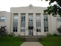 | Alpena County Courthouse | building | 1983 | 83003643 |
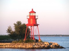 | Alpena Light | structure | 2006 | 06000197 |
| Besser, Herman and Hattie (Ely), House | building | 2023 | 100009278 | |
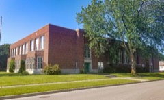 | Bingham School | building | 2020 | 100005778 |
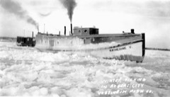 | Fishing Tug Katherine V | structure | 2003 | 03000622 |
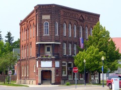 | IOOF Centennial Building | building | 2015 | 15000944 |
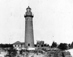 | Middle Island Light | structure | 2006 | 06000133 |
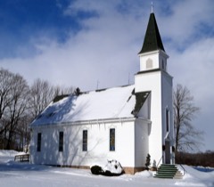 | Norwegian Lutheran Church Complex | building | 2013 | 13000478 |
 | PEWABIC (propeller) Shipwreck Site | site | 2016 | 14001096 |
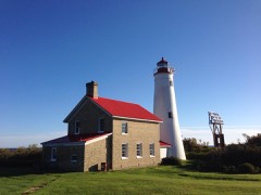 | Thunder Bay Island Light Station | building | 1984 | 84001371 |
Every wildfire the federal occurrence database records inside this county: 273 of them, burning about 576 acres. 8 started naturally and 17 were recorded as arson. Each settlement page carries the fires within five miles of it.
| Reported cause | Fires |
|---|---|
| Debris and open burning | 85 |
| Missing data/not specified/undetermined | 63 |
| Equipment and vehicle use | 49 |
| Arson/incendiarism | 17 |
| Recreation and ceremony | 14 |
| Misuse of fire by a minor | 11 |
| Railroad operations and maintenance | 11 |
| Natural | 8 |
| Smoking | 8 |
| Power generation/transmission/distribution | 4 |
| Other causes | 2 |
| Fireworks | 1 |
The five largest, by the area the report gives. One of them was set deliberately.
| Date | Cause | Size | Reported by | Name on the report |
|---|---|---|---|---|
| 14 April 2003 | Equipment and vehicle use | 117 acres | Michigan Department of Natural Resources | BEAVER CREEK FIRE |
| 29 October 1994 | Arson/incendiarism | 52 acres | Michigan Department of Natural Resources | not named |
| 29 March 2015 | Missing data/not specified/undetermined | 33 acres | Michigan Department of Natural Resources | ALPENA 04 |
| 12 April 1993 | Debris and open burning | 15 acres | Michigan Department of Natural Resources | not named |
| 6 April 2011 | Missing data/not specified/undetermined | 13 acres | Michigan Department of Natural Resources | ALPENA 01 |
| 3 April 2013 | Missing data/not specified/undetermined | 11 acres | Michigan Department of Natural Resources | ALPENA 01 |
| 13 April 1993 | Debris and open burning | 10 acres | Michigan Department of Natural Resources | not named |
| 6 October 2012 | Recreation and ceremony | 9.9 acres | Michigan Department of Natural Resources | ALPENA 22 |
Every settlement page carries the fires within five miles of it - see the settlement index below.
The NOAA Storm Events Database holds 157 reports for this county, causing no deaths, 4 injuries and about $913,750 in recorded property damage. Each settlement page carries the reports that name it.
| Kind of event | Reports |
|---|---|
| Thunderstorm Wind | 92 |
| Hail | 49 |
| Tornado | 14 |
| Waterspout | 1 |
| Lightning | 1 |
The most serious of them, by death, then injury, then recorded damage. The accounts are quoted exactly as the forecast office filed them.
| When | Event | Place named | Harm | What the report says |
|---|---|---|---|---|
| June 1992 | Thunderstorm Wind | not stated | 3 hurt | no account filed |
| July 2005 | Lightning | Alpena | 1 hurt | A nearby lightning strike at a campground shocked a man who was taking down an awning. He was taken to a local hospital for observation. |
| October 2007 | Tornado (EF2) | Hubbard Lake | $245,000 | The third tornado from this parent thunderstorm, and sixth and final tornado of the day, this one was only on the ground momentarily, with a quarter-mile long track. However, this quick touchdown produced substantial damage near Borke Road. One home had its second story ripped off. A nearby mobile home was destroyed, and two barns were significantly damaged. Some livestock (cows and chickens) were killed. Trees in the area were also heavily damaged. Winds were estimated at up to 110 mph, making it an EF2. |
| October 2007 | Tornado (EF2) | Lachine | $240,000 | The Long Rapids tornado touched down initially near Hodgins Road, and tracked northeast for 4 miles, ending just north of Long Rapids Road on McNeil Road. The most concentrated property damage was near Hodgins Road. Three homes suffered roof and siding damage, and three barns were destroyed or heavily damaged. A garage and a shed were also destroyed, and there was substantial tree damage. Winds were estimated at 120 mph, making it an EF2. |
| August 1993 | Thunderstorm Wind | Alpena | $50,000 | A barn was blown over on Hubbard Lake road. |
| August 1993 | Thunderstorm Wind | Alpena | $50,000 | A garage roof was blown over onto a car by thunderstorm wind. |
| July 2005 | Thunderstorm Wind | Lakewood | $35,000 | Several large trees uprooted near the south end of Long Lake. A shed was crushed by a falling tree, and some homes were damaged by trees and other debris. In Alpena, part of a large tent erected for a local festival was brought down. |
| July 2005 | Thunderstorm Wind | Long Rapids | $30,000 | Large trees, limbs, and power lines were downed. A garage, a shed, and a flatbed truck were all destroyed by falling trees. |
| June 1992 | Tornado (F1) | not stated | $25,000 | no account filed |
| June 1992 | Tornado (F1) | not stated | $25,000 | no account filed |
| August 1988 | Tornado (F1) | not stated | $25,000 | no account filed |
| July 1964 | Tornado (F1) | not stated | $25,000 | no account filed |
| July 2016 | Thunderstorm Wind | Kerston | $20,000 | Farm buildings were damaged by strong thunderstorm winds. |
| July 2007 | Thunderstorm Wind | (Apn)Phelps Arpt Alp | $18,000 | A large tree was blown over at the Alpena Regional Airport. A large tree was downed onto a house on the southwest side of Alpena, along US-23. |
| October 2007 | Thunderstorm Wind | Hubbard Lake | $15,000 | Thunderstorm winds caused sporadic tree damage in southeast Alpena County. Minor damage to mobile homes occurred near Shawlani Road. |
| August 2006 | Thunderstorm Wind | Ossineke | $15,000 | Numerous trees downed, one leaning onto a house. Another tree pulled up a gas line as it was being uprooted. |
| July 2016 | Thunderstorm Wind | Alpena | $10,000 | Several trees were downed. |
| July 2005 | Thunderstorm Wind | Lachine | $10,000 | Trees were downed onto a house. |
| June 2011 | Thunderstorm Wind | (Apn)Phelps Arpt Alp | $8,000 | Numerous trees downed in central Alpena County. |
| June 2004 | Tornado (F0) | Lachine | $6,000 | The tornado lifted just after moving into Alpena County. Over twenty trees were downed at the Thunder Bay Golf Resort. |
| August 2021 | Thunderstorm Wind | Kerston | $5,000 | Social media report of multiple trees down on Indian Reserve Rd south of KAPN. |
| July 2006 | Thunderstorm Wind | Spratt | $5,000 | Numerous trees downed at Moores Landing. |
| April 1993 | Thunderstorm Wind | Alpena | $5,000 | Strong thunderstorm winds uprooted several large trees near Highway M-32. |
| August 2020 | Thunderstorm Wind | Leer | $4,000 | Trees were downed onto power lines near Leer and Olsen Roads. |
| August 2018 | Thunderstorm Wind | Alpena Jct | $4,000 | Power poles and power lines were downed. |
| June 2010 | Thunderstorm Wind | Lakewood | $4,000 | Four to five trees were downed at US-23 and Bloom Road. |
| June 2005 | Thunderstorm Wind | Hubbard Lake | $4,000 | Trees and power lines were downed onto Carriveau Road. |
| July 2021 | Thunderstorm Wind | Alpena | $3,000 | Several trees down in Washington Avenue Park. Social media pictures included uprooted trees and a blown over portable toilet. |
| August 2021 | Thunderstorm Wind | Spratt | $3,000 | Reports of trees downed near Spratt. |
| August 2021 | Thunderstorm Wind | Lachine | $3,000 | Reports of trees downed near Lachine. |
| August 2021 | Thunderstorm Wind | Ossineke | $3,000 | Downed trees across M-23 in Ossineke. Time estimated from radar. |
| July 2007 | Thunderstorm Wind | Hubbard Lake | $3,000 | Several trees were downed onto power lines, near M-65 about a mile south of MacDonald Road. |
| June 2007 | Thunderstorm Wind | Alpena | $3,000 | A tree and a few large tree limbs were downed on 2nd Avenue and on Sable Street, near the northern city limits of Alpena. |
| July 2006 | Thunderstorm Wind | Long Rapids | $3,000 | Numerous thunderstorms moved across Northern Lower Michigan in the evening. Only one became severe, downing trees on Maple Lane near M-65. |
| August 2015 | Thunderstorm Wind | Spratt | $2,000 | A spotter estimated winds of 60 mph, and several large tree limbs were downed. |
| August 2006 | Thunderstorm Wind | Lachine | $2,000 | Two large trees downed along M-32. |
| June 2005 | Thunderstorm Wind | Long Rapids | $2,000 | A large tree was downed across a road. |
| June 2005 | Thunderstorm Wind | Cathro | $1,000 | A large willow tree was downed by wind. |
| August 1993 | Thunderstorm Wind | Alpena | $500 | A 12-inch-diameter tree was blown over on Long Rapids Road within two blocks northwest of the city limits in Alpena. A wind gust was estimated at 50 mph. |
| August 1993 | Thunderstorm Wind | Alpena | $500 | A 12-inch-diameter tree was uprooted on fair street in the city of Alpena. |
| August 1993 | Thunderstorm Wind | Alpena | $500 | A 15-inch-diameter tree was uprooted on Dow Road in the city of Alpena as reported by a student volunteer. |
| August 1993 | Thunderstorm Wind | Alpena | $500 | Several large trees were uprooted by thunderstorm wind. |
| August 1988 | Tornado (F0) | not stated | $250 | no account filed |
| June 1982 | Tornado (F0) | not stated | $250 | no account filed |
| April 1980 | Tornado (F0) | not stated | $250 | no account filed |
| August 2025 | Hail | Lachine | - | Multiple reports of hailstones up to 2 inches in diameter in the Lachine and Flanders areas in west central Alpena county, Michigan. Hail accumulated on decks and resulted in multiple instances of car and home damage, as well as some damage to trees. |
| August 2025 | Hail | Alpena | - | Multiple reports of hailstones up to 2 inches in diameter near El Cajon and Misery Bays on the Lake Huron coast east of Alpena. |
| July 2024 | Thunderstorm Wind | Alpena | - | Report from social media of a tree snapped at its base, downing wires and a power pole. Rainfall report from the Alpena area of 2.41 inches of rain with thunderstorms with standing water in yard. |
| July 2016 | Hail | Alpena | - | Some damage done to area crops, including wheat and soybeans. |
| July 2008 | Thunderstorm Wind | Lachine | - | A spotter estimated 60 mph winds. |
| July 2007 | Hail | Lachine | - | Penny sized hail fell at Thunder Bay Golf Club. In addition, 40 mph wind gusts downed small tree limbs. |
| July 2007 | Thunderstorm Wind | Ossineke | - | Spotter estimated wind gust. |
| August 2005 | Hail | Spratt | - | A small cluster of thunderstorms developed in northeast Lower Michigan on the afternoon of the 1st. One became severe. |
| August 2004 | Thunderstorm Wind | Hubbard Lake | - | Tree limbs were downed. |
| July 2003 | Thunderstorm Wind | Alpena | - | Numerous trees and utility lines were downed. |
| August 2003 | Thunderstorm Wind | Long Rapids | - | Large tree limbs were downed. |
| June 2001 | Thunderstorm Wind | Lachine | - | Several six inch branches blown down. |
| June 2001 | Thunderstorm Wind | Hubbard Lake | - | One mile path of trees uprooted by thunderstorm winds. |
| June 2001 | Tornado (F0) | Alpena Arpt | - | Pilot reported tornado at the Alpena airport. No damage was reported. |
| August 2000 | Thunderstorm Wind | Ossineke | - | Several 24 inch diameter trees were blown down. |
The Survey's mineral resources record lists 13 workings inside this county. 5 still produce and 8 are closed or unrecorded. Each settlement page carries the workings within five miles of it.
| Commodity | Workings |
|---|---|
| Sand and Gravel, Construction | 6 |
| Stone, Crushed/Broken | 2 |
| Silica | 1 |
| Stone | 1 |
| Clay | 1 |
| Limestone, General | 1 |
| Cement Rock | 1 |
The least common of them first, because a county's hundredth gravel pit says nothing its first ten did not.
| Where | Site | Commodity | Status | Recorded |
|---|---|---|---|---|
| Alpena Quarry | Cement Rock | Producer | 1908 | |
| Limestone Quarry-National Gypsum | Stone | Producer | ||
| Paxton Pit | Clay | Past Producer | ||
| Rockport Quarry | Limestone, General | Past Producer | 1915 | |
| Roleau Sand Pits | Silica | Past Producer | ||
| Alpena Plant | Stone, Crushed/Broken | Plant | ||
| Great Lakes Stone and Lime Co. | Stone, Crushed/Broken | Past Producer | ||
| Alpena Aggregate Pit | Sand and Gravel, Construction | Producer | ||
| Alpena Co Pit Re Glancy Inc | Sand and Gravel, Construction | Producer | ||
| Copping Pit & Mill | Sand and Gravel, Construction | Past Producer | ||
| Dowling Pit | Sand and Gravel, Construction | Past Producer | ||
| Dubey M.C. Pit and Mill | Sand and Gravel, Construction | Past Producer | ||
| Klein Pit & Mill | Sand and Gravel, Construction | Past Producer |
Centennial History of Alpena County, Michigan : Giving Sketch of Michigan from Its Early Settlement, Fortunes and Misfortunes of First Settlers, the Survey, Settlement, and Growth of Alpena County from 1837-1876 devotes a chapter to each township: its boundaries and streams, who settled it and when, the mills, the schools and the churches. The one chapter is reproduced here in full. Each row shows the township's own shape and where it lies in the county, drawn from the Census Bureau's boundary. Which settlements belong to which township is computed from that same boundary, not taken from the book.
| Shape and position in the county | Township | Settlements in it | Length | Sections |
|---|---|---|---|---|
| Ossineke Township | Hubbard Lake | 198 words | 1 |
One book written about this county, cut here where the book itself is cut, at its printed chapters: 7 chapters in all. Every chapter is public domain, machine-read from the scan and reproduced complete. A chapter already given under one of the county's towns is not repeated in this list.
| Chapter | Length |
|---|---|
| Preliminary Remarks | 9,120 words |
| Topographical and Geological Character of the County | 5,758 words |
| Organization | 7,679 words |
| Chapter with an unread heading (no. 4 of those read) | 18,424 words in 2 parts |
| Communication | 9,217 words |
| Chapter 9: Financial | 725 words |
| Chapter 10: Aiaeriages, Births, Etc | 3,666 words |
Named settlements recorded in the Geographic Names Information System, each with the topographic sheets covering it. Villages, hamlets and abandoned places alike. Each is shown with the nearest named watercourse or landform and the survey quadrangle it falls on.
Alpena township · 49707 · Near Cow Island · Alpena quadrangle
8 sheets, 1954 to 1984
Ossineke township · 49747 · On Simmons Creek · Hubbard Lake quadrangle
9 sheets, 1954 to 1983
Long Rapids township · 49753 · On Morrison Creek · Lachine quadrangle
7 sheets, 1954 to 1984
Long Rapids township · 49753 · On Gaffney Creek · Polaski quadrangle
7 sheets, 1954 to 1984
Sanborn township · 49766 · On North Branch Devils River · Ossineke quadrangle
9 sheets, 1954 to 1983