 Block
From the record
11 National Register listings published here.
Sources: the National Register database, National Park Service
90 topographic sheets cover 40 settlements here, and 11 properties are on the National Register of Historic Places.
11 National Register listings published here.
Sources: the National Register database, National Park Service
Every property in this county listed on the National Register of Historic Places, with the year it was listed and the federal nomination document.
| Photograph | Property | Type | Listed | Reference |
|---|---|---|---|---|
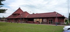 | Chicago and Northwestern Railroad Depot | building | 1985 | 85000095 |
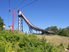 | Copper Peak | site | 1973 | 73000948 |
 | Solomon S. Curry House | building | 1982 | 82002833 |
 | Gogebic County Courthouse | building | 1981 | 81000306 |
 | Ironwood Carnegie Library | building | 2011 | 11000948 |
 | Ironwood City Hall | building | 1980 | 80001856 |
 | Ironwood Theatre Complex | building | 1985 | 85000061 |
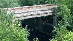 | Main Street-Black River Bridge | structure | 1999 | 99001514 |
 | Memorial Building | building | 1980 | 80001857 |
 | Planter Road-Jackson Creek Bridge | structure | 1999 | 99001515 |
| Rice Bay | site | 2015 | 15000353 |
Every wildfire the federal occurrence database records inside this county: 94 of them, burning about 213 acres. 23 started naturally and 3 were recorded as arson. Each settlement page carries the fires within five miles of it.
| Reported cause | Fires |
|---|---|
| Natural | 23 |
| Recreation and ceremony | 19 |
| Debris and open burning | 15 |
| Equipment and vehicle use | 13 |
| Missing data/not specified/undetermined | 13 |
| Power generation/transmission/distribution | 4 |
| Smoking | 4 |
| Arson/incendiarism | 3 |
The five largest, by the area the report gives. None of them was recorded as arson.
| Date | Cause | Size | Reported by | Name on the report |
|---|---|---|---|---|
| 7 April 2012 | Missing data/not specified/undetermined | 53 acres | Ottawa National Forest | OLD US 2 FIRE |
| 25 September 2003 | Natural | 31 acres | Michigan Department of Natural Resources | not named |
| 9 October 2012 | Natural | 29 acres | Ottawa National Forest | FISHER FIRE |
| 3 May 1999 | Natural | 20 acres | Ottawa National Forest | OX YOKE LAKE |
| 5 May 2018 | Equipment and vehicle use | 9.0 acres | Michigan Department of Natural Resources | S BLACK RIVER ROAD |
| 20 May 2018 | Equipment and vehicle use | 8.3 acres | Ottawa National Forest | BLACK RIVER |
| 1 May 2003 | Debris and open burning | 8.0 acres | Michigan Department of Natural Resources | not named |
| 12 October 1995 | Debris and open burning | 7.4 acres | Michigan Department of Natural Resources | not named |
Every settlement page carries the fires within five miles of it - see the settlement index below.
The NOAA Storm Events Database holds 224 reports for this county, causing 2 deaths, 2 injuries and about $28,739,000 in recorded property damage. Each settlement page carries the reports that name it.
| Kind of event | Reports |
|---|---|
| Thunderstorm Wind | 126 |
| Hail | 68 |
| Heavy Rain | 11 |
| Flash Flood | 6 |
| Flood | 6 |
| Tornado | 5 |
| Lightning | 2 |
The most serious of them, by death, then injury, then recorded damage. The accounts are quoted exactly as the forecast office filed them.
| When | Event | Place named | Harm | What the report says |
|---|---|---|---|---|
| August 1998 | Thunderstorm Wind | Watersmeet | 1 killed, $5,000 | Large trees down. One tree fell on fiber-glass camper resulting in a fataility at Imp Lake Campground in Ottawa National Forest. |
| June 2006 | Lightning | Wakefield | 1 killed | A 50-year old man was struck and killed by lightning while standing under a tree near Sunday Lake in Wakefield. |
| July 2020 | Thunderstorm Wind | White City | 1 hurt, $10,000 | Law enforcement reported a tree fell on a vehicle near Gogebic Lodge and the nearby bait and tackle shop. The male occupant in the car was injured. The time of the report was estimated from radar. |
| June 2005 | Lightning | Wakefield | 1 hurt | A 41 year-old man was struck by lightning while mowing his lawn. |
| April 2023 | Flood | Junet | $20,000,000 | The Gogebic County Road Commission reported numerous secondary roads and a few county roads impassable from the 13th into the 17th. Highway M-28 east of Sunday Lake in Wakefield was closed from the 16th into the 21st due to high water. Estimated countywide damages to highway infrastructure were in the millions of dollars. Governor Whitmer declared a state of emergency in Gogebic County on April 14th due to severe and widespread flooding. |
| July 2016 | Flash Flood | Junet | $5,000,000 | Radar estimated rainfall amounts of 3 to 6 inches caused major flash flooding over portions of far western Gogebic County and left many sections of road washed out and impassible. Many people became stranded from near Ironwood to Little Girls Point. The Gogebic County Sheriff reported the Montreal River flooded on Lake Road at the Michigan-Wisconsin border with a washout of the guardrail at the Flint Creek ravine. A Gogebic County patrol car was swept up in the Montreal River flood waters and the deputy driving the car needed to be rescued.The Gogebic County Road Commission closed Lake Road from near Saxon Harbor, WI to Lower Powers Road. |
| July 2016 | Thunderstorm Wind | Wakefield | $1,000,000 | The NWS storm survey concluded that damage in and immediately surrounding Wakefield was caused by straight-line thunderstorm winds up to 90 mph. Wind damage included an overturned camper trailer, a roof ripped off an old skating rink, a few damaged or destroyed outbuildings, hundreds of large uprooted or snapped trees (some 30 to 40 inches in diameter), downed power lines, and several trees downed on houses or vehicles. The survey team could not access all areas around Wakefield due to the number of downed trees. The time of the report was based on radar, observations and interviews of individuals in the area. |
| April 2013 | Flood | Ironwood | $1,000,000 | Rapid melting of significant late season snow pack caused moderate flooding of roads in the Ironwood, Bessemer, Wakefield and Marenisco areas from the 28th into the 30th. Minor flooding continued into early May. Some flooding of basements was also reported. A portion of Highway M-28 was closed in Wakefield due to flooding from Sunday Lake. Governor Rick Snyder declared a state of disaster in Gogebic County where nearly one million dollars of property damage occurred due to the flooding mainly to roadway infrastructure. |
| July 2006 | Hail | Wakefield | $750,000 | Hail up to 4 inches in diameter resulted in significant damage to roofs, siding, and automobiles. |
| June 2018 | Flood | Junet | $344,000 | The Gogebic County Sheriff reported vehicles stranded on streets in Ironwood with multiple closures of roads due to flood waters, including Highway US-2 between Lowell Street and Douglas Boulevard. Multiple basements were also flooded in the Ironwood area with estimated rainfall reports between four and five inches. Governor Rick Snyder declared a state of disaster in Gogebic County as damage estimates from the flooding were estimated at nearly $344,000. |
| July 2021 | Thunderstorm Wind | Marenisco | $100,000 | Extensive straight-line wind damage was found in and around the town of Marenisco with estimated wind speeds up to 90 mph. Some structural damage was found, but most of the damage was uprooted or snapped trees. The main structural damage was significant roof damage to a newly-built garage at the corner of Hall and Mill Streets in Marenisco where over a quarter of the metal roof and decking was stripped back and torn from the roof trusses. A continuous swath of straight-line wind damage started approximately five miles west of town to six miles southeast of town and continued into the Ottawa National Forest. Campers were trapped at Bobcat Lake Campground due to fallen trees, but no injuries were reported. Many roads were closed due to fallen trees in the area, and numerous power outages were reported. The time of the report was estimated from radar. |
| July 2016 | Tornado (EF1) | Puritan | $100,000 | The NWS storm survey confirmed a low end EF1 tornado about three miles south of Bessemer. Winds from the tornado were estimated around 90 mph. The tornado touched down near the intersection of S. Barber Road and Spruce Road and ended 2.4 miles to the east-northeast, just northeast of the intersection of W. Harding Road and Koski Road. Damage included multiple trees down on a garage on Spruce Street and half a barn destroyed in Bessemer Township on Elder Street. |||The damage path was 200 yards wide or less and occurred just before midnight CDT. |
| July 2016 | Thunderstorm Wind | Connorville | $50,000 | Numerous trees were reported down in Porcupine Mountains State Park from thunderstorm winds. A cabin was also reportedly destroyed. |
| July 2016 | Tornado (EF1) | Hurley | $50,000 | An EF1 tornado touched down near the Wisconsin-Michigan border just southeast of Van Buskirk and caused damage for less than a mile before dissipating. Damage consisted mostly of uprooted or snapped trees. |
| July 2008 | Thunderstorm Wind | Cisco Lake | $40,000 | Several one to two-foot diameter trees were snapped off or uprooted by the strong winds. Branches from the fallen trees damaged a vehicle, a boat and roofs of several cabins. |
| July 2021 | Thunderstorm Wind | Hurley | $30,000 | The Ironwood Public Safety Department reported extensive storm damage throughout Gogebic County with numerous trees and power lines down. The time of the report was estimated from radar. |
| June 2005 | Tornado (F1) | Marenisco | $25,000 | This tornado developed on the west side of Lake Gogebic. The brief touchdown flipped over a pontoon boat, damaging the boat, boat lift and dock. |
| April 1984 | Tornado (F1) | not stated | $25,000 | no account filed |
| June 2018 | Flash Flood | Ironwood | $20,000 | Possible roads washed out near Cloverland Cinemas per Public Safety Radio. Much of Ironwood, including stores along Highway US-2, was without electricity on Sunday evening the 17th due to storms and flooding. Homeowners reported flooded basements. |
| July 1999 | Thunderstorm Wind | Ironwood | $15,000 | Over 100 trees down on Lake Rd. Two houses and a car were damaged by falling trees. |
| July 2023 | Thunderstorm Wind | Beaton | $10,000 | The U.S. Forest Service reported a wide variety of scattered multiple trees and large branches down throughout the Sylvania Wilderness Area in eastern Gogebic County during an onsite survey by USFS personnel in the Ottawa National Forest. The time of the delayed report was based on radar. Estimated wind gusts were between 50 and 70 mph. |
| June 2018 | Thunderstorm Wind | Hurley | $10,000 | Law enforcement reported numerous trees and power lines down in the Ironwood area via Public Safety Radio. |
| July 2012 | Thunderstorm Wind | Hurley | $10,000 | Ironwood Police reported dozens of downed power lines and downed trees blocking the road. |
| July 2010 | Flood | Ironwood | $10,000 | Nearly three inches of heavy rainfall flooded a large section of US-2 from Douglas to Lowell Street in Ironwood. Several houses and building were flooded near Hemlock Street on the west side of Ironwood. |
| July 1999 | Thunderstorm Wind | Bessemer | $10,000 | Trees down on camping vehicles. |
| May 1998 | Thunderstorm Wind | Ironwood | $10,000 | no account filed |
| June 2018 | Thunderstorm Wind | Bessemer | $8,000 | Law enforcement reported numerous trees and power lines down in Bessemer via Public Safety Radio. |
| July 2023 | Thunderstorm Wind | Bessemer | $5,000 | The Gogebic County Dispatch reported power lines down in Bessemer. Wind gusts at the Ironwood ASOS were measured at 50 mph, but were probably higher in Bessemer where wind damage occurred. |
| July 2023 | Thunderstorm Wind | Indian Vlg | $5,000 | The U.S. Forest Service reported multiple trees and large branches downed of maple and fir trees along Crystal Lake Road and Birch Lake Road in eastern Gogebic County just north of the Wisconsin State line. The delayed report was estimated from radar. Winds were estimated between 50 and 70 mph. |
| July 2016 | Thunderstorm Wind | Wakefield | $5,000 | The Gogebic County Sheriff reported trees and power lines down in Wakefield. |
| September 2010 | Thunderstorm Wind | Ironwood | $5,000 | The Gogebic County Sheriff reported widespread trees and power lines down across Ironwood. A spotter also reported 12-inch diameter branches down on McLeod Avenue. Time of the reported was estimated. |
| May 2007 | Thunderstorm Wind | Watersmeet | $5,000 | Numerous trees blown down. |
| August 2006 | Thunderstorm Wind | Ironwood | $5,000 | Trees and power lines down near Gogebic County Airport. |
| July 1999 | Thunderstorm Wind | Wakefield | $5,000 | Satellite dish destroyed. One to two foot diameter pine trees were blown down. |
| July 1997 | Thunderstorm Wind | (Iwd)Ironwood Arpt | $5,000 | Strong winds ahead of a line of thunderstorms damaged a boat dock at Black River Harbor on the Lake Superior shoreline. |
| August 2020 | Flash Flood | Connorville | $4,000 | Gogebic County Sheriff's department reported that a portion of Highway US-2 was flooded with stranded vehicles. Highway US-2 was closed from Douglas Boulevard to Lowell Street. Law enforcement also reported a downed power line nearby in Ironwood. Nearly an inch and a half of rainfall from thunderstorms over a three-hour period caused the flooding. |
| June 2018 | Thunderstorm Wind | Marenisco | $4,000 | Law enforcement reported multiple trees down on Highway US-2 near Marenisco. Report relayed via Public Safety Radio. |
| July 2012 | Thunderstorm Wind | Watersmeet | $4,000 | The 911 dispatcher said they received numerous reports about downed trees and power lines. There were also reports on varying degrees of tree damage. No specifics on tree damage or location were available. |
| June 2024 | Thunderstorm Wind | Ironwood | $3,000 | Law enforcement dispatch reported a tree snapped and lying on a rooftop in the city of Ironwood. Time of the report was estimated from radar. |
| June 2024 | Thunderstorm Wind | North Ironwood | $3,000 | Law enforcement dispatch reported three trees snapped in North Ironwood. Time of the report was estimated from radar. |
| July 2016 | Thunderstorm Wind | Junet | $3,000 | Gogebic County Sheriff's office reported large trees in excess of 12 inches in diameter down across Lake Road near Upper Powers Road. The Gogebic County Road Commission was clearing the road with front end loaders. |
| June 2014 | Thunderstorm Wind | Verona | $3,000 | The State Police Dispatch reported trees down across a couple of roads in the Wakefield area, and parts of the city were without power. |
| July 2012 | Thunderstorm Wind | Bessemer | $3,000 | The sheriff received reports of numerous trees and power lines downed across Gogebic county. The public also reported an 8-inch diameter dead tree snapped at the base and a portable basketball hoop that broke in half. |
| July 2020 | Thunderstorm Wind | Verona | $2,000 | Numerous trees were reported down along old Highway US-2 near Gogebic Medical Care Facility. The time of the report was estimated from radar. |
| August 2018 | Thunderstorm Wind | Ironwood | $2,000 | Social media posts reported trees down with minor street flooding in Ironwood. |
| June 2018 | Thunderstorm Wind | Hurley | $2,000 | Law enforcement reported trees down along Pioneer Road via Public Safety Radio. |
| June 2018 | Thunderstorm Wind | Watersmeet | $2,000 | The Gogebic/Iron County Central Dispatch reported several trees down in Watersmeet. Time of the report was estimated from radar. |
| June 2016 | Thunderstorm Wind | Dunham | $2,000 | The Gogebic County Sheriff reported two trees down on Chaney Lake Road blocking traffic in both directions. |
| July 2016 | Thunderstorm Wind | Junet | $2,000 | The Gogebic County Sheriff reported several trees down along Lake Road near Little Girls Point. |
| July 2013 | Thunderstorm Wind | Hurley | $2,000 | Several trees were knocked down or snapped just north of the Wisconsin border. |
| August 2010 | Thunderstorm Wind | Wakefield | $2,000 | Multiple trees were blown down on Highway US-2 between Wakefield and Marenisco. |
| June 2007 | Thunderstorm Wind | Marenisco | $2,000 | Five large trees blown down on old US-2. |
| August 2006 | Thunderstorm Wind | Wakefield | $2,000 | Two to three-inch diameter branches down. A few trees down. |
| June 2024 | Thunderstorm Wind | Ironwood | $1,000 | A NWS student volunteer in Ironwood reported a large diameter maple tree of one foot in diameter snapped in Ironwood. Time of the report was estimated from radar. |
| June 2024 | Thunderstorm Wind | Bessemer | $1,000 | Law enforcement dispatch reported a tree down in Bessemer. Time of the report was estimated from radar. |
| June 2022 | Thunderstorm Wind | Siemens | $1,000 | Law enforcement confirmed that a couple of trees fell across the road at the intersection of Old County and Geneva Roads just southwest of Bessemer. |
| June 2022 | Thunderstorm Wind | Anvil Location | $1,000 | Law enforcement confirmed a couple of trees down near the intersection of Ramsey and Sanders Roads east of Bessemer. The time of the report was estimated from radar. |
| July 2020 | Thunderstorm Wind | Wakefield | $1,000 | A power pole was reported down on Putnam Street in Wakefield. The time of the report was estimated from radar. |
| June 2018 | Thunderstorm Wind | Ironwood | $1,000 | There was a social media report of several small poplar trees down on Sunset Road in Ironwood Township. |
| September 2017 | Thunderstorm Wind | Marenisco | $1,000 | Local law enforcement reported power lines down and trees across the road 8 miles ENE of Marenisco. |
The Survey's mineral resources record lists 116 workings inside this county. 9 still produce and 107 are closed or unrecorded. Each settlement page carries the workings within five miles of it.
| Commodity | Workings |
|---|---|
| Iron | 96 |
| Sand and Gravel, Construction | 11 |
| Copper | 4 |
| Silver | 3 |
| Gold | 2 |
| Stone, Crushed/Broken | 1 |
| Clay | 1 |
| Feldspar | 1 |
The least common of them first, because a county's hundredth gravel pit says nothing its first ten did not.
| Where | Site | Commodity | Status | Recorded |
|---|---|---|---|---|
| Goebic County Lake Clay | Clay | Prospect | ||
| Gogebic County Quarries | Stone, Crushed/Broken | Past Producer | ||
| Marenisco Feldspar Exposure | Feldspar | Prospect | ||
| Holland Prospect | Gold | Prospect | 1884 | |
| Summitt Prospect | Gold, Silver | Prospect | 1884 | |
| Copperwood | Copper, Silver | Prospect | ||
| Presque Isle Syncline | Copper, Silver | Occurrence | 1950 | |
| Peak Copper Exploration | Copper | Prospect | 1899 | |
| Presque Isle | Copper | Producer | Copper, Chalcocite | |
| Cebolski Pits | Sand and Gravel, Construction | Producer | ||
| City of Ironwood Pit | Sand and Gravel, Construction | Past Producer | ||
| Damon Lake County Pit | Sand and Gravel, Construction | Producer | ||
| Fox Valley Pit | Sand and Gravel, Construction | Producer | ||
| Globe Industries Inc Pit | Sand and Gravel, Construction | Producer | ||
| Kimberly Clark Lake Gogebic Pit | Sand and Gravel, Construction | Producer | ||
| Les Johnson Sand and Gravel Pit | Sand and Gravel, Construction | Producer | ||
| Marshall Creek Pit | Sand and Gravel, Construction | Past Producer | ||
| Randall Pit | Sand and Gravel, Construction | Producer | ||
| Weber Pit & Mill | Sand and Gravel, Construction | Producer | ||
| Wedenoja Pit | Sand and Gravel, Construction | Unknown | ||
| Anvil-Palms-Keeweenaw Group | Iron | Past Producer | 1886, 1887 | |
| Anvil-Palms-Keweenaw Group | Iron | Past Producer | 1887, 1957 | |
| Ashland Mine | Iron | Past Producer | 1884, 1926 | |
| Ashland Mine | Iron | Past Producer | 1884 | |
| Castile-Meteor Mine | Iron | Past Producer | Secondary Enrichment | |
| Chicago Mines (Sparta) | Iron | Past Producer | 1892, 1915 | |
| Chicago- Includes Former Sparta | Iron | Past Producer | 1892 | |
| Colby Mine | Iron | Past Producer | 1884, 1923 | |
| Colby Mine | Iron | Past Producer | 1884 | |
| Dean Mine | Iron | Past Producer | ||
| Eureka-Asteroid | Iron | Past Producer | 1890 | |
| Eureka-Asteroid Mine | Iron | Past Producer | 1890, 1926 | |
| Geneva Mine | Iron | Past Producer | 1848, 1887, 1965 | |
| Geneva Mine | Iron | Past Producer | 1887 | |
| Gogebic Iron District (Range) | Iron | Past Producer | 1884, 1967 | |
| Gogebic Iron District (Range) | Iron | Past Producer | ||
| Iron Ore Outcrop | Iron | Occurrence | ||
| Iron Ore Outcrop | Iron | Occurrence | ||
| Iron Ore Outcrop | Iron | Occurrence | ||
| Iron Ore Outcrop | Iron | Occurrence | ||
| Iron Ore Outcrop | Iron | Occurrence | ||
| Iron Ore Outcrop | Iron | Occurrence | ||
| Iron Ore Outcrop | Iron | Occurrence | ||
| Iron Ore Outcrop | Iron | Occurrence | ||
| Iron Ore Outcrop | Iron | Occurrence | ||
| Iron Ore Outcrop | Iron | Occurrence | ||
| Iron Ore Outcrop | Iron | Occurrence | ||
| Iron Ore Outcrop | Iron | Occurrence | ||
| Iron Ore Outcrop | Iron | Occurrence | ||
| Iron Ore Outcrop | Iron | Occurrence | ||
| Iron Ore Outcrop | Iron | Occurrence | ||
| Ironton Mine | Iron | Past Producer | 1886, 1925 | |
| Ironton Mine | Iron | Past Producer | 1886 | |
| Jackpot | Iron | Past Producer | 1892, 1904 | |
| Jackpot | Iron | Past Producer | 1892 | |
| Loomis | Iron | Past Producer | 1955 | |
| Loomis Mine | Iron | Past Producer | 1953, 1955 | |
| Mikado Mine | Iron | Past Producer | 1895, 1917 | |
| Mikado Mine | Iron | Past Producer | 1895 | |
| Newport Mine | Iron | Past Producer | 1848, 1886, 1961 | |
| Newport Mine | Iron | Past Producer | 1886 | |
| North Norrie | Iron | Past Producer | 1885 | |
| Ore Body | Iron | Occurrence | ||
| Ore Body | Iron | Occurrence | ||
| Ore Outcrop | Iron | Occurrence | ||
| Ore Outcrop | Iron | Occurrence | ||
| Ore Outcrop | Iron | Occurrence | ||
| Ore Outcrop | Iron | Occurrence | ||
| Ore Outcrop | Iron | Occurrence | ||
| Ore Outcrop | Iron | Occurrence | ||
| Ore Outcrop | Iron | Occurrence | ||
| Ore Outcrop | Iron | Occurrence | ||
| Ore Outcrop | Iron | Occurrence | ||
| Ore Outcrop | Iron | Occurrence | ||
| Ore Outcrop | Iron | Occurrence | ||
| Ore Outcrop | Iron | Occurrence | ||
| Ore Outcrop | Iron | Occurrence | ||
| Ore Outcrop | Iron | Occurrence | ||
| Ore Outcrop | Iron | Occurrence | ||
| Ore Outcrop | Iron | Occurrence | ||
| Ore Outcrop | Iron | Occurrence | ||
| Ore Outcrop | Iron | Occurrence | ||
| Ore Outcrop | Iron | Occurrence | ||
| Ore Outcrop | Iron | Occurrence | ||
| Ore Outcrop | Iron | Occurrence | ||
| Ore Outcrop | Iron | Occurrence | ||
| Ore Outcrop | Iron | Occurrence | ||
| Ore Outcrop | Iron | Occurrence | ||
| Penokee Group | Iron | Past Producer | 1848, 1884, 1904 | |
| Penokee Group | Iron | Past Producer | 1884, 1885 | |
| Peterson Mine | Iron | Past Producer | 1944, 1951 | |
| Peterson Mine (as of 1951) | Iron | Past Producer | 1884, 1937 | |
| Pike Mine | Iron | Past Producer | Secondary Enrichment | |
| Pilgrim Mine | Iron | Past Producer | Secondary Enrichment | |
| Plymouth Mine | Iron | Past Producer | 1895, 1952 | |
| Plymouth Mine | Iron | Past Producer | 1916 | |
| Puritan Mine | Iron | Past Producer | 1886, 1941 | |
| Puritan Mine | Iron | Past Producer | 1886 | |
| South Chicago | Iron | Past Producer | 1915 | |
| South Chicago Mine | Iron | Past Producer | Secondary Enrichment | |
| Sunday Lake Group | Iron | Past Producer | 1885 | |
| Sunday Lake Group Mines | Iron | Past Producer | 1885, 1961 | |
| Tilden Mine | Iron | Past Producer | 1891 | |
| Townsite Mine | Iron | Past Producer | 1884, 1885 | |
| Vicar Mine | Iron | Past Producer | 1950 | |
| Vicar Mine (Wakefield Lease) | Iron | Past Producer | 1950, 1951 | |
| Wakefield Mine | Iron | Past Producer | 1912, 1913, 1959 | |
| Wakefield Mine | Iron | Past Producer | 1913 | |
| Wakefield Morgan Mine | Iron | Past Producer | 1923 | |
| Wakefield Section 8 | Iron | Past Producer | ||
| Wakefield-Morgan Mine | Iron | Past Producer | 1923, 1925 | |
| Wakefield-Section 8 Reserve | Iron | Prospect | Secondary Enrichment | |
| Whiteside Mine | Iron | Past Producer | ||
| Whiteside Reserve | Iron | Prospect | Secondary Enrichment | |
| Yale Mine | Iron | Past Producer | 1886, 1925 | |
| Yale Mine | Iron | Past Producer | 1886 |
Named settlements recorded in the Geographic Names Information System, each with the topographic sheets covering it. Villages, hamlets and abandoned places alike. Each is shown with the nearest named watercourse or landform and the survey quadrangle it falls on.
Ironwood Charter Township · 49911 · On Sixmile Creek · Copper Peak quadrangle
9 sheets, 1953 to 1999
Ironwood Charter Township · 49938 · Near Point Mountain · Little Girls Point quadrangle
10 sheets, 1943 to 1989
Wakefield township · 49968 · On Connor Creek · Thomaston quadrangle
13 sheets, 1956 to 1999
Marenisco township · 49947 · On Monarch Creek · Wakefield NE quadrangle
13 sheets, 1955 to 1999
Marenisco township · 49947 · On Kinnickinnic Creek · Marenisco quadrangle
13 sheets, 1955 to 1999
Ironwood Charter Township · 49938 · Near Mount Zion · Ironwood quadrangle
14 sheets, 1943 to 1980
Ironwood Charter Township · 49938 · On Welch Creek · North Ironwood quadrangle
9 sheets, 1953 to 1999
Watersmeet township · 49969 · Near Draper Island · Imp Lake quadrangle
15 sheets, 1938 to 1999
Marenisco township · 49947 · On Marenisco Creek · Marenisco quadrangle
13 sheets, 1955 to 1999
Ironwood Charter Township · 49911 · On Powder Mill Creek · Copper Peak quadrangle
9 sheets, 1953 to 1999
Wakefield township · 49968 · On Planter Creek · Thomaston quadrangle
13 sheets, 1956 to 1999
Bessemer township · 49959 · On Little Black River · Wakefield quadrangle
13 sheets, 1955 to 1999
Watersmeet township · 49969 · On Tamarack River · Fuller quadrangle
14 sheets, 1952 to 1999
Wakefield township · 49968 · On Berranger Creek · Thomaston quadrangle
13 sheets, 1956 to 1999
Wakefield township · 49968 · On Little Black River · Wakefield quadrangle
13 sheets, 1955 to 1999
Watersmeet township · 49969 · On Duck Creek · Watersmeet quadrangle
15 sheets, 1952 to 1999
Marenisco township · 49947 · On Finn Creek · Stateline Lake quadrangle
12 sheets, 1955 to 1999
Marenisco township · 49947 · On White Horse Creek · Marshall Creek quadrangle
12 sheets, 1955 to 1999