 Block
From the record
9 National Register listings published here.
Sources: the National Register database, National Park Service
54 topographic sheets cover 42 settlements here, and 9 properties are on the National Register of Historic Places.
9 National Register listings published here.
Sources: the National Register database, National Park Service
Every property in this county listed on the National Register of Historic Places, with the year it was listed and the federal nomination document.
| Photograph | Property | Type | Listed | Reference |
|---|---|---|---|---|
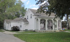 | Liberty Hyde Bailey Birthplace | building | 1983 | 83000892 |
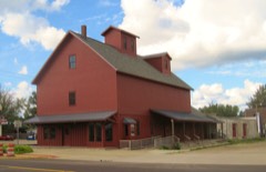 | Bangor Elevator | building | 2009 | 09000523 |
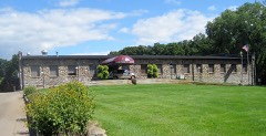 | Houppert Winery Complex | building | 2000 | 00000222 |
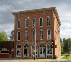 | Marshall's Store | building | 2002 | 02000205 |
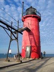 | Navigation Structures at South Haven Harbor, Michigan | structure | 1995 | 95001160 |
| Nichols Hotel | building | 2025 | 100011633 | |
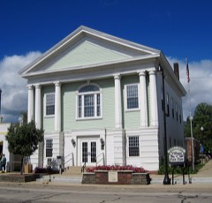 | Paw Paw City Hall | building | 1972 | 72000657 |
 | Van Buren County Courthouse Complex | building | 1979 | 79001169 |
Every wildfire the federal occurrence database records inside this county: 162 of them, burning about 201 acres. 11 started naturally and 1 was recorded as arson. Each settlement page carries the fires within five miles of it.
| Reported cause | Fires |
|---|---|
| Missing data/not specified/undetermined | 68 |
| Equipment and vehicle use | 59 |
| Debris and open burning | 13 |
| Natural | 11 |
| Recreation and ceremony | 9 |
| Smoking | 1 |
| Arson/incendiarism | 1 |
The five largest, by the area the report gives. None of them was recorded as arson.
| Date | Cause | Size | Reported by | Name on the report |
|---|---|---|---|---|
| 25 December 2019 | Equipment and vehicle use | 10 acres | Michigan Department of Natural Resources | BANGOR COMMUNITY FD 536 - 2019 |
| 26 March 2019 | Missing data/not specified/undetermined | 7.0 acres | Michigan Department of Natural Resources | VAN BUREN 01 |
| 20 September 2003 | Recreation and ceremony | 6.2 acres | Michigan Department of Natural Resources | not named |
| 18 April 2004 | Equipment and vehicle use | 5.1 acres | Michigan Department of Natural Resources | not named |
| 8 May 2018 | Equipment and vehicle use | 5.0 acres | Michigan Department of Natural Resources | LAWTON FD 0000045 - 2018 |
| 24 April 2017 | Recreation and ceremony | 5.0 acres | Michigan Department of Natural Resources | VAN BUREN 01 |
| 5 May 2018 | Equipment and vehicle use | 5.0 acres | Michigan Department of Natural Resources | COLUMBIA TOWNSHIP FD 0000026 - 2018 |
| 7 May 2018 | Equipment and vehicle use | 4.0 acres | Michigan Department of Natural Resources | COVERT FD 0000167 - 2018 |
Every settlement page carries the fires within five miles of it - see the settlement index below.
The NOAA Storm Events Database holds 281 reports for this county, causing 1 death, 34 injuries and about $69,065,750 in recorded property damage. Each settlement page carries the reports that name it.
| Kind of event | Reports |
|---|---|
| Thunderstorm Wind | 178 |
| Hail | 69 |
| Tornado | 19 |
| Flash Flood | 7 |
| Funnel Cloud | 4 |
| Lightning | 2 |
| Waterspout | 1 |
| Flood | 1 |
The most serious of them, by death, then injury, then recorded damage. The accounts are quoted exactly as the forecast office filed them.
| When | Event | Place named | Harm | What the report says |
|---|---|---|---|---|
| May 1984 | Thunderstorm Wind | not stated | 1 killed, 2 hurt | no account filed |
| May 1980 | Tornado (F3) | not stated | 15 hurt, $2,500,000 | no account filed |
| April 1956 | Tornado (F3) | not stated | 9 hurt, $2,500,000 | no account filed |
| August 1989 | Thunderstorm Wind | not stated | 4 hurt | no account filed |
| July 2011 | Lightning | Lacota | 2 hurt | Multiple media sources reported a lightning strike injured two males who were picking blueberries at the time. |
| September 1986 | Tornado (F2) | not stated | 1 hurt, $250,000 | no account filed |
| June 1979 | Tornado (F2) | not stated | 1 hurt, $25,000 | no account filed |
| April 2010 | Hail | Lawton | $50,000,000 | Trained spotters across the far southeastern portion of Van Buren county reported hail up to one and a quarter inches in diameter and wind damage. Several trees were blown down and the large wind driven hail resulted in siding damage to homes across that area. |
| June 2022 | Thunderstorm Wind | Toquin | $3,000,000 | Trained spotters reported numerous trees and tree limbs and power lines down across mainly southern Van Buren county. Hail up to one inch in diameter was also reported. Two miles west of Lawrence there was a higher concentration of several dozen large healthy tree trunks snapped, uprooted, or large limbs snapped. Damage occurred to at least 3 residences due to fallen trees, one probably a total loss, another with significant roof damage. Cleanup was still ongoing 12 days after the storms struck. Just east of Hartford, hundreds of trees were scattered within approximately a 6 square-mile area with large limbs snapped, trunks snapped, or uprooted. Damage was centered in and near the Van Buren County Youth Fair. The Van Buren Historical Society Museum had damage to the back of the building due to fallen tree limbs. |
| April 2013 | Flood | South Haven | $3,000,000 | Significant flooding occurred on rivers and streams across Van Buren county due to heavy rainfall from early to mid April. |
| April 1956 | Tornado (F3) | not stated | $2,500,000 | no account filed |
| June 2020 | Thunderstorm Wind | Forest Dunes | $1,000,000 | Severe thunderstorm downburst winds brought down numerous large trees in swaths near and just west of Covert and also in and near Lawrence and Paw Paw. Several garages and outbuildings also sustained damage. |
| February 2024 | Thunderstorm Wind | Lawton | $250,000 | A trained spotter three miles south southwest of Lawton reported that several trees and power lines were blown down onto county road 669 just north of 79th street. Several trees and limbs were blown down onto homes and outbuildings in the area. |
| November 2013 | Thunderstorm Wind | Mattawan Arpk | $250,000 | An NWS storm survey indicated that microburst straight line wind damage with maximum winds of 75 mph caused part of the roof of Mattawan high school to be torn off. Several trees were blown down and awning and roof damage was also incurred at an apartment. |
| May 1989 | Tornado (F2) | not stated | $250,000 | no account filed |
| March 1976 | Tornado (F2) | not stated | $250,000 | no account filed |
| May 1954 | Tornado (F2) | not stated | $250,000 | no account filed |
| June 2024 | Thunderstorm Wind | Lawton | $200,000 | Numerous trees were blown down near Lawton. |
| September 1997 | Lightning | South Haven | $200,000 | South Haven Community Hospital received a direct lightning strike on the northwest corner of the building. The radio tower for the HERN radio, which is the communications link with area ambulances, sustained the strike, which then grounded through the building directly through the telephone communications center on the basement level. The entire telephone system was disabled beyond repair. |
| June 1997 | Flash Flood | County-Wide | $125,000 | Van Buren County officials reported damage from flash flooding late Friday night and early Saturday morning, June 20th and 21st, respectively. The flooding caused 8 road washouts and 35 additional roads were impassable for a time due to water flowing across them. A 15-foot section of the Kal-Haven Trail (a bike and nature trail) was washed out, leaving a gulley 8-feet deep. Baer Park in downtown South Haven was also flooded. Unofficially, 5 to 7 inches of rain fell in the 5-hour time period ending 4:00 AM EDT in Lawrence. |
| August 2011 | Flash Flood | Van Buren Bluffs | $100,000 | Numerous roads were washed out as reported by road commission. Flash flooding occurred on 2nd avenue in South Haven and forced the cancellation of the National Blueberry Festival. |
| June 2010 | Tornado (EF0) | Gobles Wesler Arpt | $100,000 | The tornado touched down briefly just south of 20th Avenue causing damage to one property. A metal outbuilding lost its tin roof. Numerous snapped branches were found at treetop level. No damage to the residence was evident. The tornado then skipped across an open area with little to no damage. The tornado then touched down in a cornfield with evidence in the broken cornstalks. The path then moved into a line of trees. Approximately 20 trees were uprooted or snapped. A new camping trailer was flipped into a house. The tornado then lifted in the backyard of the residence. |
| August 2007 | Thunderstorm Wind | Bloomingdale | $100,000 | A 69 mph wind gust was measured in Bloomingdale. Numerous trees and power lines were blown down with some trees blocking roads. A tree was reported down on a house as well. |
| February 2001 | Flash Flood | Countywide | $100,000 | no account filed |
| May 2000 | Flash Flood | Countywide | $100,000 | no account filed |
| May 2024 | Thunderstorm Wind | Decatur | $50,000 | Several trees were uprooted and snapped off near Decatur and large hail was reported as well. |
| September 2018 | Thunderstorm Wind | Sister Lakes | $50,000 | Dozens of trees were blown down in the Sister Lakes area and scattered power outages were reported. |
| September 2014 | Thunderstorm Wind | Armstrong Corners | $50,000 | Numerous trees were blown down across portions of Van Buren county. |
| December 2007 | Thunderstorm Wind | Lawton | $50,000 | Numerous trees were blown down in Lawton. |
| December 2007 | Thunderstorm Wind | Gobles Wesler Arpt | $50,000 | Numerous trees and power lines were blown down across Van Buren county. |
| July 2006 | Thunderstorm Wind | Bloomingdale | $50,000 | Many trees were blown down across Van Buren county and particularly in and near Bloomingdale. |
| July 2006 | Thunderstorm Wind | Gobles | $50,000 | Numerous trees were blown down in Bloomingdale and Gobles. |
| May 2004 | Thunderstorm Wind | Paw Paw | $50,000 | The general public reported that numerous trees were blown down in Paw Paw. |
| July 2003 | Hail | Paw Paw | $50,000 | Two inch diameter hail was reported by area law enforcement in Paw Paw. Another report of three quarters inch hail was received from Paw Paw. |
| June 2001 | Thunderstorm Wind | Bangor | $50,000 | no account filed |
| August 2001 | Flash Flood | Countywide | $50,000 | no account filed |
| June 2000 | Thunderstorm Wind | Bloomingdale | $50,000 | no account filed |
| May 2000 | Hail | Paw Paw | $50,000 | no account filed |
| May 2000 | Hail | Hartford | $50,000 | no account filed |
| August 2000 | Thunderstorm Wind | Decatur | $50,000 | no account filed |
| December 2007 | Thunderstorm Wind | Paw Paw | $40,000 | A square yard of shingles was blown off a roof of an eight year old home. Downed trees and limbs were blocking county road 653. |
| March 2007 | Thunderstorm Wind | South Haven | $40,000 | Law enforcement reported that numerous trees were blown down by severe thunderstorm wind gusts in South Haven and Bangor. |
| May 2004 | Thunderstorm Wind | Lawrence | $30,000 | Law enforcement in Lawrence reported that several trees were blown down. |
| August 2024 | Thunderstorm Wind | Teapot Dome | $25,000 | Law enforcement reported that several large trees and limbs were blown down near Lawrence, Decatur and Lawton. |
| July 2022 | Thunderstorm Wind | Lawrence Arpt | $25,000 | Several trees were blown down. |
| August 2020 | Thunderstorm Wind | Mattawan Arpk | $25,000 | There were several reports of downed trees across portions of Van Buren county. |
| November 2020 | Thunderstorm Wind | Decatur | $25,000 | Several trees were blown down across parts of Van Buren county. |
| August 2014 | Thunderstorm Wind | South Haven | $25,000 | A Van Buren county official reported that numerous trees were blown down in South Haven with several other reports of downed trees from the western half of Van Buren county inluding in Grand Junction. |
| August 2006 | Hail | Grand Jct | $25,000 | State police reported that three inch diameter hail fell in and just east of Grand Junction and that hail covered the ground for a short duration. |
| June 2003 | Hail | Paw Paw | $25,000 | Seven eighths inch diameter hail was reported with a severe thunderstorm in Paw Paw, and a tree was blown down in Mattawan. |
| August 2003 | Hail | Grand Jct | $25,000 | One and three quarters inch diameter hail was reported in Grand Junction. |
| July 2003 | Thunderstorm Wind | South Haven | $25,000 | Severe thunderstorm wind gusts blew down large trees, branches and numerous power lines in South Haven and Hartford. |
| April 2001 | Hail | Gobles | $25,000 | no account filed |
| April 2001 | Hail | Bangor | $25,000 | no account filed |
| August 2000 | Thunderstorm Wind | Sister Lakes | $25,000 | no account filed |
| September 2000 | Thunderstorm Wind | Grand Jct | $25,000 | no account filed |
| July 2000 | Thunderstorm Wind | Bangor | $25,000 | no account filed |
| May 1989 | Tornado (F2) | not stated | $25,000 | no account filed |
| July 1988 | Tornado (F0) | not stated | $25,000 | no account filed |
| May 1956 | Tornado (F2) | not stated | $25,000 | no account filed |
The Survey's mineral resources record lists 13 workings inside this county. 6 still produce and 7 are closed or unrecorded. Each settlement page carries the workings within five miles of it.
| Commodity | Workings |
|---|---|
| Sand and Gravel, Construction | 6 |
| Silica | 5 |
| Fire Clay (Refractory) | 2 |
The least common of them first, because a county's hundredth gravel pit says nothing its first ten did not.
| Where | Site | Commodity | Status | Recorded |
|---|---|---|---|---|
| Acolliney Clay Pit | Fire Clay (Refractory) | Past Producer | ||
| Fish and Steward Clay Pit | Fire Clay (Refractory) | Past Producer | ||
| Austin Site | Silica | Past Producer | Sedimentary | |
| Busse Site | Silica | Producer | Sedimentary | |
| Garlanger Site | Silica | Past Producer | Sedimentary | |
| Nadeau Site | Silica | Past Producer | Sedimentary | |
| Rose Pit | Silica | Past Producer | Sedimentary | |
| Budzen Pit | Sand and Gravel, Construction | Producer | ||
| J V Burkett Construction Co. Pit | Sand and Gravel, Construction | Past Producer | ||
| Klett Sand and Gravel Pit | Sand and Gravel, Construction | Producer | ||
| Plopper Pit & Mill | Sand and Gravel, Construction | Producer | ||
| Van Buren County Pit | Sand and Gravel, Construction | Producer | ||
| Van Buren County Pit | Sand and Gravel, Construction | Producer |
Named settlements recorded in the Geographic Names Information System, each with the topographic sheets covering it. Villages, hamlets and abandoned places alike. Each is shown with the nearest named watercourse or landform and the survey quadrangle it falls on.
Bloomingdale township · 49026 · On Haven and Max Lake Drain · Bloomingdale quadrangle
13 sheets, 1946 to 1982
Covert township · 49043 · Near Thunder Mountain · Covert quadrangle
11 sheets, 1927 to 1981
South Haven city · 49090 · On Black River · South Haven quadrangle
11 sheets, 1927 to 1981
Geneva township · 49090 · On Cedar Creek · McDonald quadrangle
11 sheets, 1927 to 1981
Covert township · 49043 · On Brandywine Creek · Covert quadrangle
11 sheets, 1927 to 1981
South Haven Charter Township · 49090 · Lacota quadrangle
11 sheets, 1927 to 1981
Covert township · 49043 · On Brandywine Creek · Covert quadrangle
11 sheets, 1927 to 1981
Paw Paw township · 49079 · On East Branch Paw Paw River · Paw Paw quadrangle
12 sheets, 1944 to 1982
South Haven city · 49090 · On Black River · South Haven quadrangle
11 sheets, 1927 to 1981
South Haven Charter Township · 49090 · On Butternut Creek · Lacota quadrangle
11 sheets, 1927 to 1981