 Block
From the record
One of 87 National Register listings published here for Washtenaw County · listed in 2020 · category: District.
Sources: the National Register database, National Park Service
Listed on the National Register of Historic Places in 2020.
One of 87 National Register listings published here for Washtenaw County · listed in 2020 · category: District.
Sources: the National Register database, National Park Service
Regional context, not property-specific evidence. The federal wildfire occurrence database lists 21 fires within 5 miles of Highland Cemetery between 2018 and 2020, burning about 21 acres in total. 1 started naturally. None was recorded as arson. Distance is straight-line from the map coordinates, so a fire counted here may appear on a neighbouring settlement's page as well.
| Reported cause | Fires |
|---|---|
| Missing data/not specified/undetermined | 12 |
| Equipment and vehicle use | 6 |
| Smoking | 1 |
| Debris and open burning | 1 |
| Natural | 1 |
The most recent of them, most recent first, with the day each was reported and the service that recorded it.
| Date | Cause | Size | Reported by | Name on the report |
|---|---|---|---|---|
| 6 September 2019 | Missing data/not specified/undetermined | 1.0 acres | Michigan Department of Natural Resources | ANN ARBOR FD 751468 - 2019 |
| 3 August 2019 | Smoking | 1.0 acres | Michigan Department of Natural Resources | VAN BUREN TOWNSHIP FD 0001606 - 2019 |
| 13 July 2018 | Missing data/not specified/undetermined | 1.0 acres | Michigan Department of Natural Resources | YPSILANTI TOWNSHIP FD 0002536 - 2018 |
| 26 June 2019 | Missing data/not specified/undetermined | 1.0 acres | Michigan Department of Natural Resources | SUPERIOR TOWNSHIP FD 0000516 - 2019 |
| 24 June 2019 | Equipment and vehicle use | 1.0 acres | Michigan Department of Natural Resources | SUPERIOR TOWNSHIP FD 0000502 - 2019 |
| 10 June 2020 | Missing data/not specified/undetermined | under an acre | Michigan Department of Natural Resources | PITTSFIELD TOWNSHIP DPS 2000626 - 2020 |
| 2 May 2018 | Missing data/not specified/undetermined | 1.0 acres | Michigan Department of Natural Resources | YPSILANTI TOWNSHIP FD 0001609 - 2018 |
| 14 May 2019 | Natural | 1.0 acres | Michigan Department of Natural Resources | ANN ARBOR FD 465207 - 2019 |
Regional context, not property-specific evidence. The federal mineral resources record lists 6 workings within 5 miles of Highland Cemetery: 3 past producers, 2 producers, 1 prospect. 2 still produce. What was taken out: Sand and Gravel, Construction, Fire Clay (Refractory). Distance is straight-line from the map coordinates, so a quarry counted here may appear on a neighbouring settlement's page as well.
| Where | Site | Commodity | Status | Recorded |
|---|---|---|---|---|
| Paint Creek Clay Deposit | Fire Clay (Refractory) | Prospect | ||
| Berlin Pit and Mill | Sand and Gravel, Construction | Past Producer | ||
| Kruse Gravel Pit | Sand and Gravel, Construction | Producer | ||
| Liberty Pit and Mill | Sand and Gravel, Construction | Producer | ||
| O E Gooding & Co. Pit | Sand and Gravel, Construction | Past Producer | ||
| O E Gooding & Co. Pit | Sand and Gravel, Construction | Past Producer |
Regional context, not property-specific evidence. The National Weather Service names Ypsilanti, the town this property stands in, in 51 storm reports between 1997 and 2023: 27 thunderstorm wind, 20 hail, 4 lightning. No death or injury is recorded in these reports. Each account below is quoted exactly as the forecast office filed it, from the NOAA Storm Events Database, and each date opens the federal record of that event.
| When | Event | Place named | Harm | What the report says |
|---|---|---|---|---|
| June 2005 | Thunderstorm Wind | Ypsilanti | $50,000 | Trees and power lines were brought down on the south side of Ypsilanti. Tree damage was heavy along Hawkins, First and Harriet streets. A telephone pole on Armstrong Street was snapped. |
| March 1998 | Thunderstorm Wind | Ypsilanti | $30,000 | no account filed |
| May 1998 | Lightning | Ypsilanti | $18,000 | no account filed |
| June 2011 | Thunderstorm Wind | Ypsilanti | $10,000 | A large tree was uprooted and fell onto a house. |
| June 2001 | Lightning | Ypsilanti | $10,000 | Lightning struck Edmunson Middle School in Ypsilanti Township, igniting the roof of the gymnasium. |
| July 2001 | Hail | Ypsilanti | $10,000 | Several vehicles damaged by hail at state police post. |
| June 1999 | Lightning | Ypsilanti | $10,000 | Lightning struck an apartment building and started a fire. |
| May 2000 | Thunderstorm Wind | Ypsilanti | $8,000 | no account filed |
| June 1998 | Thunderstorm Wind | Ypsilanti | $5,000 | no account filed |
| May 2011 | Thunderstorm Wind | Ypsilanti | $2,000 | Large tree limbs were reported down, along with damage to a church. |
| October 1997 | Lightning | Ypsilanti | $2,000 | Lightning struck a house, blowing a hole in a wall and doing about 2000 dollars worth of damage. |
| June 2001 | Thunderstorm Wind | Ypsilanti | $1,000 | Large tree limbs were downed. In nearby Ann Arbor, a 48 mph gust was measured. |
| October 2018 | Thunderstorm Wind | Ypsilanti | - | A large tree was blown down onto a parked car. |
| July 2014 | Thunderstorm Wind | Ypsilanti | - | Four inch diameter tree limb reported down. |
| July 2014 | Thunderstorm Wind | Ypsilanti | - | Spotter estimated a 60 mph thunderstorm wind gust. |
| June 2008 | Thunderstorm Wind | Ypsilanti | - | Measured wind gust of 58 mph by Ypsilanti ASOS. |
| June 2007 | Thunderstorm Wind | Ypsilanti | - | Law enforcement reported a tree 1 foot in diameter down. |
| June 2005 | Thunderstorm Wind | Ypsilanti | - | Numerous large tree limbs were reported blown down. |
| September 2005 | Thunderstorm Wind | Ypsilanti | - | A trained spotter reported telephone poles broken and estimated wind gusts to 70 MPH. |
| May 2004 | Thunderstorm Wind | Ypsilanti | - | Law enforcement reported trees blown down. |
| April 2003 | Thunderstorm Wind | Ypsilanti | - | Spotters reported 9 to 12 inch diameter tree limbs blown down in thunderstorm winds. |
| April 2003 | Thunderstorm Wind | Ypsilanti | - | Trained spotters reported several 9 inch diameter tree limbs blown down in thunderstorm winds. |
| August 2003 | Thunderstorm Wind | Ypsilanti | - | Spotters reported a 8 inch diameter tree blown down. |
| August 2003 | Thunderstorm Wind | Ypsilanti | - | A trained weather spotter reported large trees down. |
| July 2003 | Thunderstorm Wind | Ypsilanti | - | A boat capsized on Ford Lake, but all of its passengers were rescued without incident. |
| July 2003 | Thunderstorm Wind | Ypsilanti | - | A trained spotter reported trees and power lines blown down. |
| July 2002 | Thunderstorm Wind | Ypsilanti | - | The general public reported several large trees blown down. |
| September 2001 | Thunderstorm Wind | Ypsilanti | - | Trees blown down. |
| July 2023 | Hail | Ypsilanti | - | no account filed |
| August 2020 | Thunderstorm Wind | Ypsilanti | - | no account filed |
| May 2014 | Hail | Ypsilanti | - | no account filed |
| July 2013 | Hail | Ypsilanti | - | no account filed |
| June 2010 | Hail | Ypsilanti | - | no account filed |
| April 2009 | Thunderstorm Wind | Ypsilanti | - | no account filed |
| March 2006 | Hail | Ypsilanti | - | no account filed |
| March 2006 | Hail | Ypsilanti | - | no account filed |
| June 2006 | Hail | Ypsilanti | - | no account filed |
| September 2005 | Hail | Ypsilanti | - | no account filed |
| May 2004 | Hail | Ypsilanti | - | no account filed |
| May 2004 | Hail | Ypsilanti | - | no account filed |
| May 2004 | Hail | Ypsilanti | - | no account filed |
| May 2004 | Thunderstorm Wind | Ypsilanti | - | no account filed |
| May 2004 | Hail | Ypsilanti | - | no account filed |
| July 2004 | Hail | Ypsilanti | - | no account filed |
| May 2003 | Hail | Ypsilanti | - | no account filed |
| June 2002 | Hail | Ypsilanti | - | no account filed |
| October 2001 | Thunderstorm Wind | Ypsilanti | - | no account filed |
| May 2000 | Hail | Ypsilanti | - | no account filed |
| October 1999 | Hail | Ypsilanti | - | no account filed |
| June 1999 | Hail | Ypsilanti | - | no account filed |
| June 1998 | Hail | Ypsilanti | - | no account filed |
No historic map-sheet match is published for this property yet. That does not mean no map exists. This record needs a coordinate-quality review before it can be joined to a sheet boundary. Browse the county's mapped places while that work is pending.
Other National Register properties close enough to walk or drive between, ordered by distance from this one. Both positions come from the same geocoding pass that matched these properties to their map sheets.
| Photograph | Property | Distance | Listed |
|---|---|---|---|
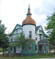 | Brinkerhoff-Becker House | 0.8 miles | 1982 |
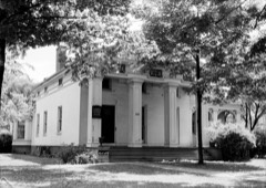 | Ladies' Literary Club Building | 0.8 miles | 1972 |
 | Ypsilanti Historic District (Boundary Increase) | 0.9 miles | 1989 |
 | Pease Auditorium | 0.9 miles | 1984 |
 | Ypsilanti Historic District | 1.0 miles | 1978 |
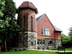 | Starkweather Religious Center | 1.0 miles | 1977 |
| National Archives record | The nomination case file for reference 100005026 in Record Group 79. |
| Washtenaw County | All 87 listed properties in this county. |