
BlockBefore
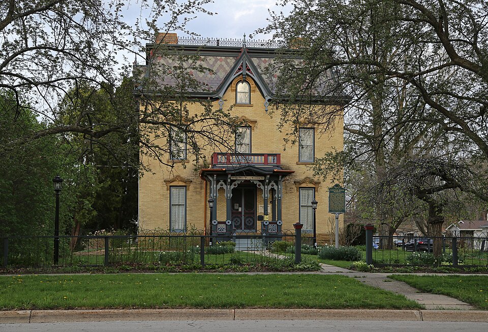
Photograph of Gardner House
Photograph by Christopher L. Riley, CC BY-SA 4.0. Via Wikimedia Commons.

Gardner House

Listed on the National Register of Historic Places in 1971.

From the record

“Gardner Mansion, was built as a single-family home located at 509 South Superior Street in Albion, Michigan. It was listed on the National Register of Historic Places in 1971.”

Wikipedia article Gardner House (Albion, Michigan), CC BY-SA 4.0.

One of 50 National Register listings published here for Calhoun County · listed in 1971 · category: Building.

Sources: the Wikipedia article · the case file at the National Archives · the National Register database, National Park Service · the Wikipedia article

The listing

  • What is counted as historic. The nomination lists 1 building as contributing to the listing.
  • Address. 509 S. Superior St., Albion, 49713
  • When was it listed? May 1971
  • Category. building
  • Architectural style. Gothic architecture
  • National Register reference number. 71000383 - the number the National Park Service assigned this property when it was listed, and the key its nomination file is catalogued under at the National Archives.

Storms near this property

17 since 1993

Regional context, not property-specific evidence. The National Weather Service names Albion, the town this property stands in, in 17 storm reports between 1993 and 2025: 14 thunderstorm wind, 3 hail. No death or injury is recorded in these reports. Each account below is quoted exactly as the forecast office filed it, from the NOAA Storm Events Database, and each date opens the federal record of that event.

WhenEvent Place namedHarm What the report says
September 2013Thunderstorm WindAlbion$500,000A severe thunderstorm produced wind gusts of up to 70 to 80 mph that brought down numerous trees and power lines in and near Albion, resulting in numerous power outages and a closure of Albion college for several days due to all the wind damage and loss of power.
August 2007Thunderstorm WindAlbion$100,000Numerous large trees were blown down in Albion. Trees and power lines were also blown down throughout city of Battle Creek.
May 2000Thunderstorm WindAlbion$50,000no account filed
June 2015Thunderstorm WindAlbion$15,000Calhoun county central dispatch reported that several trees were blown down, mainly around Albion.
July 2004HailAlbion$10,000Three quarters inch hail was reported one mile north of Albion, and several trees were blown down just east of Marshall and two miles north of Albion.
August 2003Thunderstorm WindAlbion$10,000Three trees were blown down onto L Drive North in Albion.
April 1993Thunderstorm WindAlbion$5,000A thunderstorm wind gust of over 70 mph was recorded by the Sheridan Township Fire Department. Scattered limbs and a few pine trees were blown down around the city of Albion.
May 1996Thunderstorm WindAlbion$5,000no account filed
May 2016Thunderstorm WindAlbion$2,000A trained spotter reported a downed tree and several downed power lines near Albion.
July 1999Thunderstorm WindAlbion$1,000A tree was downed just north of Albion.
March 2025Thunderstorm WindAlbion-Trees uprooted with multiple utility poles downed.
June 2008Thunderstorm WindAlbion-Wind damage was reported near the intersection of Erie and Hannah streets, where one tree fell onto an Amtrak train resulting in damage to the brakes.
July 1998Thunderstorm WindAlbion-The Albion Recorder reported downed trees and power lines in the city of Albion. One tree fell in front of the Masonic Temple at Center and Clinton Streets. The tree fell on a power line which sparked a small fire on the utility pole. Damage estimates were not available.
September 1994HailAlbion-Hail covered ground to a depth of 0.25 inch.
April 1993Thunderstorm WindAlbion-Winds gusted to near 70 mph as the thunderstorms moved through Albion.
June 1994HailAlbion-no account filed

Every storm recorded in Calhoun County

Map coverage status

No historic map-sheet match is published for this property yet. That does not mean no map exists. This record needs a coordinate-quality review before it can be joined to a sheet boundary. Browse the county's mapped places while that work is pending.

Sources for this property

National Archives recordThe nomination case file for reference 71000383 in Record Group 79.
Wikipedia articleCommunity-written account of this property, licensed CC BY-SA.
Calhoun CountyAll 50 listed properties in this county.

Provenance

  • Listing record. National Park Service National Register of Historic Places, listed-properties dataset, current to 2026-05-22.
  • Map join. Address geocoded through the United States Census geocoder, then tested against the published boundary of every sheet in the USGS Historical Topographic Map Collection.
  • How this page is made. Listing fields come from federal records; map-sheet coverage is a labelled coordinate-to-boundary calculation, not a source-field claim.
  • Storms. NOAA National Centers for Environmental Information, Storm Events Database https://www.ncei.noaa.gov/stormevents/ A work of the United States government, no copyright under 17 U.S.C. 105. Narratives are quoted verbatim from the National Weather Service report and are not edited or summarised.