
BlockBefore
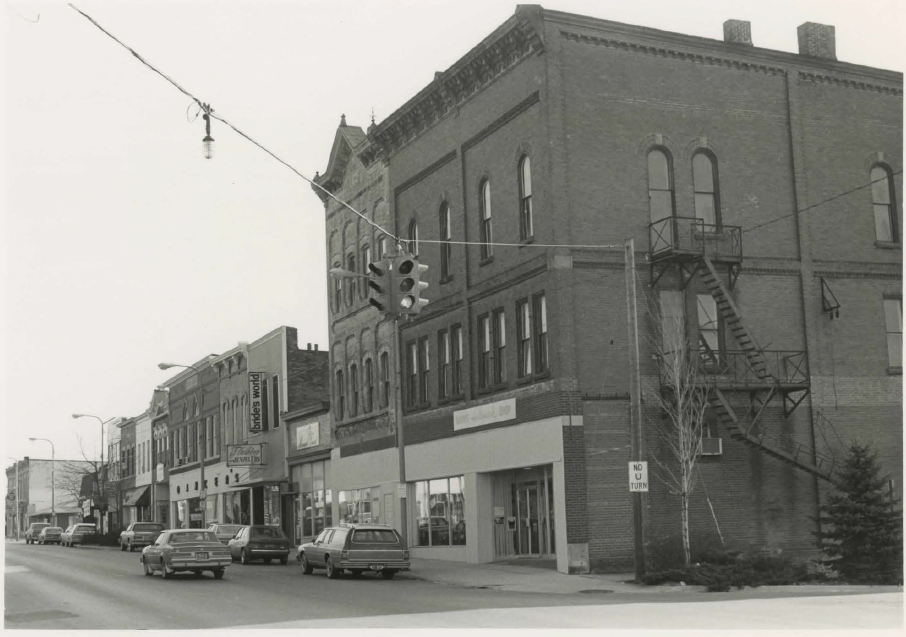
Photograph of Main Street Historic District
Photograph by Timothy Leonard, Public domain. Via Wikimedia Commons.

Main Street Historic District

Listed on the National Register of Historic Places in 1983.

From the record

“The Main Street Historic District, located in Flushing Michigan, includes buildings on Main St from Maple to 628 (East) Main St. Properties in this district are listed on the National Register of Historic Places. 82 structures located on 22.4 acres of land create the district with commercial buildings reflecting ornate Italianate and early twentieth-century styles constructed between 1850 and 1918 and residences exhibiting a wide variety of Greek Revival, Italianate, Queen Anne, Colonial Revival, and Bungaloid styles and their vernacular derivatives built from 1850 to 1932..”

Wikipedia article Main Street Historic District (Flushing, Michigan), CC BY-SA 4.0.

One of 73 National Register listings published here for Genesee County · listed in 1983 · category: District.

Sources: the Wikipedia article · the case file at the National Archives · the National Register database, National Park Service · the Wikipedia article

The listing

  • Address. Main St. from Maple to 628 Main St., Flushing, 48116
  • When was it listed? June 1983
  • Category. district
  • Also known as. Genesee County MRA
  • National Register reference number. 83000846 - the number the National Park Service assigned this property when it was listed, and the key its nomination file is catalogued under at the National Archives.

Storms near this property

32 since 1995

Regional context, not property-specific evidence. The National Weather Service names Flushing, the town this property stands in, in 32 storm reports between 1995 and 2021: 21 thunderstorm wind, 7 hail, 2 tornado, 1 lightning. No death or injury is recorded in these reports. Each account below is quoted exactly as the forecast office filed it, from the NOAA Storm Events Database, and each date opens the federal record of that event.

WhenEvent Place namedHarm What the report says
July 2021Tornado (EF1)Flushing$1,000,000The tornado path extended from just northeast of Calkins and North McKinley Rd, just west of Elms Rd between Corunna and Calkins Rd. The most significant damage, consistent with EF1 damage, was along Calkins Rd, west of Morrish Road; and along Morrish Road, south of Calkins Rd. Peak winds were estimated at 100 mph. Notable damage included three garages that were either partially or completely destroyed. Additional damage included minor structural damage to adjacent homes, including the loss of roofing materials and siding. There was sporadic tree and crop damage along the path.
May 2002Thunderstorm WindFlushing$100,000A National Weather Service storm survey determined that a downburst (strait line thunderstorm winds) hit portions of northeastern Flushing Township and northwestern Mt Morris Township. Damage included numerous downed trees and limbs, some of which fell onto homes and cars. The downburst was aproximately 4 miles long and 2 to 3 miles wide.
September 2007Thunderstorm WindFlushing$25,000A National Weather Service storm survey revealed a classic downburst/straight-line wind event in Flushing. Total damage included over a dozen trees uprooted, a dozen more snapped off at the trunk, widespread large tree branches down, and one garage door blown inward. Wind speeds were estimated at 80 MPH.
July 2012Thunderstorm WindFlushing$15,000Trees down throughout the city, along with numerous power lines down.
July 2010Thunderstorm WindFlushing$15,000Numerous trees and large tree limbs down.
September 2006LightningFlushing$10,000A local newspaper reported that lightning had struck a tornado siren in Flint Township. A new siren will cost the Township $10K.
May 1998Tornado (F0)Flushing$10,000no account filed
May 1998Thunderstorm WindFlushing$5,000no account filed
July 1995Thunderstorm WindFlushing$5,000no account filed
July 2007Thunderstorm WindFlushing$3,000A trained spotter reported a tree 3 inches in diameter and power lines down.
August 2021Thunderstorm WindFlushing-Multiple trees uprooted with large tree limbs down.
June 2020Thunderstorm WindFlushing-A tree was reported to be blown onto a house.
May 2019Thunderstorm WindFlushing-A few trees and power lines were reported down, with one tree falling onto a house.
October 2017Thunderstorm WindFlushing-A tree was reported blown down onto a house.
July 2012Thunderstorm WindFlushing-A large tree was reported down.
June 2009Flash FloodFlushing-Water was covering Elms Road.
July 2007Thunderstorm WindFlushing-A trained spotter reported large limbs down.
July 2007Thunderstorm WindFlushing-Law enforcement reported several tree branches 6 inches in diameter down.
June 2007Thunderstorm WindFlushing-A trained spotter reported two trees down.
October 2007Thunderstorm WindFlushing-Large tree branches down at Mount Morris and Seymour roads from an NWS storm survey.
July 2006Thunderstorm WindFlushing-Trained spotter reported 30 trees blown down.
August 2006Thunderstorm WindFlushing-A trained spotter measured a peak wind gust at 64 MPH.
July 2006Thunderstorm WindFlushing-A trained spotter estimated thunderstorm wind gusts of 65 mph.
April 2002Thunderstorm WindFlushing-Law Enforcement reported large tree limbs blown down.
August 2020HailFlushing-no account filed
June 2006HailFlushing-no account filed
June 2004HailFlushing-no account filed
May 2004HailFlushing-no account filed
July 1999HailFlushing-no account filed
May 1998Thunderstorm WindFlushing-no account filed

Every storm recorded in Genesee County

Map coverage status

No historic map-sheet match is published for this property yet. That does not mean no map exists. This record needs a coordinate-quality review before it can be joined to a sheet boundary. Browse the county's mapped places while that work is pending.

Sources for this property

National Archives recordThe nomination case file for reference 83000846 in Record Group 79.
Wikipedia articleCommunity-written account of this property, licensed CC BY-SA.
Genesee CountyAll 73 listed properties in this county.

Provenance

  • Listing record. National Park Service National Register of Historic Places, listed-properties dataset, current to 2026-05-22.
  • Map join. Address geocoded through the United States Census geocoder, then tested against the published boundary of every sheet in the USGS Historical Topographic Map Collection.
  • How this page is made. Listing fields come from federal records; map-sheet coverage is a labelled coordinate-to-boundary calculation, not a source-field claim.
  • Storms. NOAA National Centers for Environmental Information, Storm Events Database https://www.ncei.noaa.gov/stormevents/ A work of the United States government, no copyright under 17 U.S.C. 105. Narratives are quoted verbatim from the National Weather Service report and are not edited or summarised.