 Block
From the record
One of 80 National Register listings published here for Iron County · listed in 1983 · category: Building.
Sources: the case file at the National Archives · the National Register database, National Park Service
Listed on the National Register of Historic Places in 1983.
One of 80 National Register listings published here for Iron County · listed in 1983 · category: Building.
Sources: the case file at the National Archives · the National Register database, National Park Service
Regional context, not property-specific evidence. The federal wildfire occurrence database lists 44 fires within 5 miles of H.W. Harte Block-Chrystal Falls Village Hall between 1992 and 2019, burning about 67 acres in total. 1 started naturally. 4 were recorded as arson. Distance is straight-line from the map coordinates, so a fire counted here may appear on a neighbouring settlement's page as well.
| Reported cause | Fires |
|---|---|
| Equipment and vehicle use | 9 |
| Missing data/not specified/undetermined | 6 |
| Debris and open burning | 5 |
| Misuse of fire by a minor | 5 |
| Recreation and ceremony | 4 |
| Arson/incendiarism | 4 |
| Railroad operations and maintenance | 4 |
| Power generation/transmission/distribution | 3 |
| Smoking | 2 |
| Fireworks | 1 |
| Natural | 1 |
The most recent of them, most recent first, with the day each was reported and the service that recorded it.
| Date | Cause | Size | Reported by | Name on the report |
|---|---|---|---|---|
| 25 August 2011 | Power generation/transmission/distribution | 1.0 acres | Michigan Department of Natural Resources | LIND ROAD |
| 9 June 1994 | Equipment and vehicle use | under an acre | Michigan Department of Natural Resources | not named |
| 9 June 1994 | Equipment and vehicle use | 1.1 acres | Michigan Department of Natural Resources | not named |
| 9 June 1994 | Equipment and vehicle use | under an acre | Michigan Department of Natural Resources | not named |
| 21 June 2003 | Railroad operations and maintenance | under an acre | Michigan Department of Natural Resources | not named |
| 14 June 2014 | Arson/incendiarism | under an acre | Michigan Department of Natural Resources | IRON 0006 |
| 11 June 2003 | Debris and open burning | under an acre | Michigan Department of Natural Resources | not named |
| 11 June 1992 | Misuse of fire by a minor | under an acre | Michigan Department of Natural Resources | not named |
Regional context, not property-specific evidence. The federal mineral resources record lists 182 workings within 5 miles of H.W. Harte Block-Chrystal Falls Village Hall: 69 past producers, 62 occurrences, 49 prospects, 2 producers. 2 still produce. What was taken out: Iron, Sand and Gravel, Construction. Distance is straight-line from the map coordinates, so a quarry counted here may appear on a neighbouring settlement's page as well.
| Where | Site | Commodity | Status | Recorded |
|---|---|---|---|---|
| Paint Pit and Mill | Sand and Gravel, Construction | Producer | ||
| Williams Pit | Sand and Gravel, Construction | Producer | ||
| Alpha Mine | Iron | Past Producer | 1882, 1903 | |
| Alpha Mine | Iron | Past Producer | 1903 | |
| Armania Mine | Iron | Past Producer | 1889, 1914 | |
| Armenia Mine | Iron | Past Producer | 1889 | |
| Balkan-Judson Mine | Iron | Past Producer | 1882, 1935 | |
| Balkan-Judson Mine | Iron | Past Producer | 1913 | |
| Bird Exploration | Iron | Prospect | Secondary Enrichment | |
| Book Mine | Iron | Past Producer | 1942, 1958 |
Regional context, not property-specific evidence. The National Weather Service names Crystal Falls, the town this property stands in, in 34 storm reports between 1998 and 2022: 16 thunderstorm wind, 13 hail, 2 heavy rain, 2 flood. No death or injury is recorded in these reports. Each account below is quoted exactly as the forecast office filed it, from the NOAA Storm Events Database, and each date opens the federal record of that event.
| When | Event | Place named | Harm | What the report says |
|---|---|---|---|---|
| September 2000 | Thunderstorm Wind | Crystal Falls | $3,000 | Falling tree crushed pick-up truck. |
| July 2007 | Thunderstorm Wind | Crystal Falls | $2,000 | Several one-foot diameter pine trees downed along Camp Five Road one mile south of Highway M-69. The damage path was approximately 0.6 mile in width. |
| June 2007 | Thunderstorm Wind | Crystal Falls | $1,000 | Large birch tree down across Way Dam Road. Also, a lot of small hail covering the ground. |
| September 2019 | Lightning | Crystal Falls | $500 | There was a public report of a tree struck by lightning just northwest of Crystal Falls. The tree was estimated to be three and a half feet in diameter and split in pieces. Time of the report was estimated via ENTLN lightning data. |
| June 2017 | Thunderstorm Wind | Crystal Falls | $500 | The Gogebic/Iron County Central Police Dispatch reported a tree down in Crystal Falls. |
| May 2013 | Thunderstorm Wind | Crystal Falls | $500 | A tree was reported down at 4th Street and Wisconsin Avenue. |
| April 2022 | Flood | Crystal Falls | - | Snowmelt combined with a period of heavy rain resulted in brief period of minor flooding along the Paint River near Crystal Falls on the 26th. |
| April 2019 | Flood | Crystal Falls | - | Gages Creek overflowed its banks onto private property east of Peavy Pond on April 19th. Minor flooding was also reported on the Paint and Michigamme Rivers from the 23rd into the 26th. |
| August 2015 | Hail | Crystal Falls | - | One inch diameter hail reported via social media picture at Crystal Falls. |
| August 2014 | Heavy Rain | Crystal Falls | - | The automated observing station near Crystal Falls measured 2.72 inches of rainfall in less than 24 hours. |
| October 2012 | Heavy Rain | Crystal Falls | - | The USGS rain gauge at Crystal Falls measured 2.37 inches of rainfall during the event. |
| June 2007 | Thunderstorm Wind | Crystal Falls | - | Report of several trees down. |
| June 2007 | Thunderstorm Wind | Crystal Falls | - | Report of several trees down. |
| May 2007 | Thunderstorm Wind | Crystal Falls | - | One to two-inch diameter branches down. |
| June 2005 | Thunderstorm Wind | Crystal Falls | - | Several 1-2 inch diameter tree limbs down. |
| June 2005 | Thunderstorm Wind | Crystal Falls | - | Two large trees down on Pentoga Trail in Crystal Falls Township. |
| October 2005 | Thunderstorm Wind | Crystal Falls | - | Six to eight-inch tree branches broke and fell on power lines. |
| October 2005 | Thunderstorm Wind | Crystal Falls | - | A six-inch poplar tree and an eight-inch diameter evergreen tree were downed along Highway US-2. |
| April 2004 | Hail | Crystal Falls | - | Penny sized hail was reported. |
| April 2004 | Hail | Crystal Falls | - | Nickle sized hail was reported. |
| July 2004 | Hail | Crystal Falls | - | Three-quarter inch diameter hail was reported. |
| August 2004 | Hail | Crystal Falls | - | Quarter sized hail was reported. |
| August 2004 | Thunderstorm Wind | Crystal Falls | - | Large branches were broken off. |
| August 2003 | Thunderstorm Wind | Crystal Falls | - | Numerous trees were knocked down. |
| May 2002 | Hail | Crystal Falls | - | One and three quarter inch diameter hail was reported. |
| May 2002 | Hail | Crystal Falls | - | One and three quarter inch diameter hail was reported. |
| July 2002 | Hail | Crystal Falls | - | Penny sized hail was reported. |
| July 2002 | Hail | Crystal Falls | - | One and a quarter inch diameter hail was reported. |
| September 2002 | Hail | Crystal Falls | - | Three quarter inch diameter hail was reported. |
| July 2002 | Thunderstorm Wind | Crystal Falls | - | Three to four inch diameter tree branches were broken off. |
| December 2001 | Hail | Crystal Falls | - | Penny sized hail was reported. |
| June 1999 | Thunderstorm Wind | Crystal Falls | - | wind gusts to 70 mph...large trees down |
| August 1998 | Hail | Crystal Falls | - | Small branches down. |
| June 1998 | Hail | Crystal Falls | - | no account filed |
No historic map-sheet match is published for this property yet. That does not mean no map exists. This record needs a coordinate-quality review before it can be joined to a sheet boundary. Browse the county's mapped places while that work is pending.
Other National Register properties close enough to walk or drive between, ordered by distance from this one. Both positions come from the same geocoding pass that matched these properties to their map sheets.
| Photograph | Property | Distance | Listed |
|---|---|---|---|
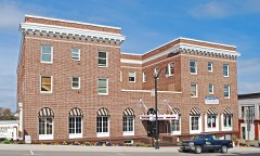 | Crystal Inn | under 500 feet | 1983 |
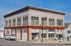 | Finnish and Swedish Mercantile Association Building | under 500 feet | 1983 |
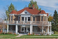 | Timothy Murphy House | under 500 feet | 1983 |
| John Hasselstrom House | under 500 feet | 1983 | |
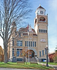 | Iron County Courthouse | under 500 feet | 1975 |
| John H. Parks Company-Wills Hardware Building | 0.1 miles | 1983 |
| National Archives record | The nomination case file for reference 83003698 in Record Group 79. |
| Iron County | All 80 listed properties in this county. |