 Block
From the record
10 National Register listings published here.
Sources: the National Register database, National Park Service
77 topographic sheets cover 40 settlements here, and 10 properties are on the National Register of Historic Places.
10 National Register listings published here.
Sources: the National Register database, National Park Service
Every property in this county listed on the National Register of Historic Places, with the year it was listed and the federal nomination document.
| Photograph | Property | Type | Listed | Reference |
|---|---|---|---|---|
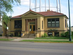 | Aitkin Carnegie Library | building | 1982 | 82002924 |
 | Aitkin County Courthouse and Jail | building | 1982 | 82002923 |
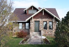 | Arthyde Stone House | building | 1982 | 82002930 |
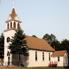 | Bethelhem Lutheran Church | building | 1982 | 82002928 |
 | Patrick Casey House | building | 1982 | 82002925 |
 | National Woodenware Company Superintendent's Residence | building | 1982 | 82002929 |
 | Northern Pacific Depot | building | 1982 | 82002926 |
 | Pine-Hickory Lakes Roadside Parking Area | site | 2016 | 16000276 |
 | Potter/Casey Company Building | building | 1982 | 82002927 |
 | Savanna Portage | site | 1973 | 73000963 |
Every wildfire the federal occurrence database records inside this county: 1,408 of them, burning about 23,964 acres. 23 started naturally and 225 were recorded as arson. Each settlement page carries the fires within five miles of it.
| Reported cause | Fires |
|---|---|
| Debris and open burning | 612 |
| Missing data/not specified/undetermined | 235 |
| Arson/incendiarism | 225 |
| Equipment and vehicle use | 166 |
| Recreation and ceremony | 64 |
| Smoking | 28 |
| Power generation/transmission/distribution | 26 |
| Natural | 23 |
| Railroad operations and maintenance | 14 |
| Misuse of fire by a minor | 8 |
| Other causes | 4 |
| Fireworks | 3 |
The five largest, by the area the report gives. Five of them were set deliberately.
| Date | Cause | Size | Reported by | Name on the report |
|---|---|---|---|---|
| 2 April 2015 | Missing data/not specified/undetermined | 3,200 acres | Minnesota Department of Natural Resources | not named |
| 14 April 2009 | Arson/incendiarism | 1,150 acres | Minnesota Department of Natural Resources | not named |
| 28 April 1997 | Arson/incendiarism | 930 acres | Minnesota Department of Natural Resources | not named |
| 17 March 2012 | Arson/incendiarism | 850 acres | Minnesota Department of Natural Resources | ST. PATRICK'S DAY FIRE |
| 30 April 1996 | Arson/incendiarism | 725 acres | Minnesota Department of Natural Resources | not named |
| 24 October 1999 | Equipment and vehicle use | 700 acres | Minnesota Department of Natural Resources | MCGRATH FIRE |
| 25 March 1999 | Arson/incendiarism | 679 acres | Minnesota Department of Natural Resources | not named |
| 30 May 1997 | Debris and open burning | 640 acres | Minnesota Department of Natural Resources | not named |
Every settlement page carries the fires within five miles of it - see the settlement index below.
The NOAA Storm Events Database holds 374 reports for this county, causing 1 death, 4 injuries and about $4,167,250 in recorded property damage. Each settlement page carries the reports that name it.
| Kind of event | Reports |
|---|---|
| Thunderstorm Wind | 180 |
| Hail | 139 |
| Tornado | 22 |
| Flash Flood | 16 |
| Flood | 13 |
| Lightning | 3 |
| Heavy Rain | 1 |
The most serious of them, by death, then injury, then recorded damage. The accounts are quoted exactly as the forecast office filed them.
| When | Event | Place named | Harm | What the report says |
|---|---|---|---|---|
| August 1969 | Tornado (F3) | not stated | 1 killed, 3 hurt, $250,000 | no account filed |
| August 2018 | Thunderstorm Wind | Waukenabo | 1 hurt | The roof of a trailer home collapsed and the home sustained other significant damage from the storm. A 10 year-old girl was trapped inside and her leg was crushed and fractured due to the damage. Downed trees were also blocking State Highway 3. |
| August 1969 | Tornado (F4) | not stated | $2,500,000 | no account filed |
| June 2024 | Tornado (EF1) | Aitkin | $500,000 | Another tornado developed on the northern portion of Hammal lake, where localized pockets of extensive tree damage were located, and one three-season cabin and boat house were completely destroyed and partially thrown into the water. The tornado continued east- southeast, uprooting and snapping several mature tree trunks as it crossed Highway 169 and Hanging Kettle Lake. The tornado then took a east-southeastward path through Ripple Lake, uprooting trees and knocking over an 85 foot tall antenna tower before the tornado ended over southeastern Ripple Lake. No fatalities or injuries were reported. |
| July 1985 | Tornado (F0) | not stated | $250,000 | no account filed |
| July 1978 | Tornado (F1) | not stated | $250,000 | no account filed |
| September 1977 | Tornado (F2) | not stated | $250,000 | no account filed |
| June 2024 | Tornado (EF0) | Aitkin | $50,000 | The tornado initially formed near Wolford in Crow Wing County and entered Aitkin County near the end of Cedar Lake Drive on Cedar Lake. The tornado path was to the southeast, crossing 456th Place, 320th Street, and, finally, 310th Street before lifting. This last section of the tornado path after Cedar Lake shows damage to numerous trees via satellite imagery before the visible damage path ends just to the southwest of the intersection of 310th Street and Pioneer Avenue. The tornado was rates as an EF-0 in Aitkin County, but produced EF-2 damage in Crow Wing County just before crossing into Aitkin County. No fatalities or injuries were reported. |
| July 1985 | Tornado (F2) | not stated | $25,000 | no account filed |
| July 1952 | Tornado (F2) | not stated | $25,000 | no account filed |
| June 2025 | Thunderstorm Wind | Aitkin | $20,000 | A large oak tree was down on a house with other trees also down on powerlines. |
| August 2025 | Thunderstorm Wind | Mc Gregor | $10,000 | A large tree down estimated to be 12 inches in diameter was down onto a barn roof causing damage. |
| August 2025 | Lightning | Thorp | $10,000 | A large white pine was hit by lightning and exploded causing damage to headstones and grave markers at the Thorp Cemetery. |
| July 2024 | Thunderstorm Wind | Malmo | $10,000 | Photos were received of extremely localized wind damage consisting of numerous medium to large trees snapped near the base along with upstairs windows blown in. There was no damage to nearly neighbors. A weakening storm moved overhead and likely produced a microburst over the property. |
| July 2017 | Hail | Mc Grath | $8,000 | A car was so damaged by the hail that it was declared totaled. |
| June 1983 | Tornado (F0) | not stated | $2,500 | no account filed |
| June 1973 | Tornado (F0) | not stated | $2,500 | no account filed |
| June 1968 | Tornado (F3) | not stated | $2,500 | no account filed |
| July 2014 | Hail | Jacobson | $1,000 | no account filed |
| June 1994 | Thunderstorm Wind | Aitkin | $500 | Power lines were blown over by strong thunderstorm winds. |
| July 1955 | Tornado (F1) | not stated | $250 | no account filed |
| June 2025 | Thunderstorm Wind | Waukenabo | - | A gust to 62 mph was recorded by the Waukenabo MNDOT RWIS station. |
| June 2025 | Thunderstorm Wind | Tamarack | - | A gust of 59 mph was recorded by the Tamarack MNDOT RWIS station. |
| June 2025 | Thunderstorm Wind | Sheshebee | - | Numerous large pine trees broken at their mid section. |
| June 2025 | Thunderstorm Wind | Aitkin | - | County dispatch reported multiple trees and powerlines down in Aitkin. |
| June 2025 | Thunderstorm Wind | Waukenabo | - | Several large branches were broken off at the reporter's location. |
| June 2025 | Thunderstorm Wind | Libby | - | Several large trees were down onto a driveway along with no power. |
| June 2025 | Thunderstorm Wind | Palisade | - | County dispatch reported multiple trees and powerlines down in the community of Palisade. |
| June 2025 | Thunderstorm Wind | Mc Gregor | - | County dispatch reported multiple trees down in and just north of McGregor. |
| June 2025 | Thunderstorm Wind | Palisade | - | Three large oak trees were blown over. |
| June 2025 | Thunderstorm Wind | Libby | - | Numerous reports received of large trees down around Big Sandy Lake. |
| July 2025 | Thunderstorm Wind | Minnewawa | - | Trees were down on power lines in the area. |
| July 2025 | Thunderstorm Wind | Libby | - | Several pontoon boats were flipped over on Big Sandy Lake. |
| July 2025 | Thunderstorm Wind | Hassman | - | Several five inch diameter oak tree limbs were broken off. |
| July 2025 | Thunderstorm Wind | Minnewawa | - | A large tree was blown over onto a camper at the Eagle Point Campground on Big Sandy Lake. |
| July 2025 | Thunderstorm Wind | Palisade | - | Four large oak trees were down at the spotter's location. |
| August 2025 | Thunderstorm Wind | Rossburg | - | A medium-sized tree was down partially across Highway 47. |
| August 2025 | Thunderstorm Wind | Minnewawa | - | Numerous trees were down in the vicinity of Minnesota 65 and 450th Street north of McGregor. |
| August 2025 | Thunderstorm Wind | Sheshebee | - | Several trees were down on powerlines along with several trees across County Road 6 near Round Lake. |
| August 2025 | Thunderstorm Wind | Palisade | - | A large oak tree was snapped four to six feet from the base. |
| August 2025 | Thunderstorm Wind | Libby | - | Four medium to large trees were down with one uprooted with the full root ball. One tree fell on garage. |
| July 2024 | Thunderstorm Wind | Mc Gregor | - | A video was received showing two dock pieces blowing across a parking lot. |
| July 2024 | Thunderstorm Wind | Aitkin | - | Two large oak trees were blown down from west to east. |
| August 2024 | Thunderstorm Wind | Jacobson | - | Several trees were downed on the west side of Ball Bluff Lake. |
| June 2024 | Tornado (EF0) | Glen | - | A third tornado developed near Glen, MN. Storm chaser and spotter video depict a wispy tornado with no debris visible. Due to the rural and forested nature of this damage and no reports of damage, a ground survey has not been completed. This tornado rating and details may be updated in the future as additional aerial imagery becomes available. |
| September 2023 | Thunderstorm Wind | Glory | - | Photos were received showing four pine tree trunks that had been snapped about halfway up. The trees were estimated to be about one foot in diameter. |
| September 2023 | Thunderstorm Wind | Glory | - | Photos were received of several trees that were snapped off. |
| May 2022 | Thunderstorm Wind | Cutler | - | Two pontoon boats were overturned and a boat lift was mangled. Furniture was blown off a porch. Additionally, a tree was snapped and a large branch was down as well. |
| May 2022 | Thunderstorm Wind | Aitkin | - | Multiple trees were reported down that were around a foot in diameter. A healthy tree was also snapped a few feet off the ground. |
| May 2022 | Thunderstorm Wind | East Lake | - | A few roof shingles were blown off a home. |
| May 2022 | Thunderstorm Wind | Cutler | - | Multiple trees around 20 inches in diameter were snapped and down across a road. |
| July 2022 | Thunderstorm Wind | Minnewawa | - | A tree was knocked down during the storm. |
| September 2022 | Thunderstorm Wind | Palisade | - | A medium-sized tree was downed across a county road. |
| June 2022 | Thunderstorm Wind | Aitkin | - | Numerous medium to large trees were snapped and uprooted over roadways and alleyways. |
| June 2022 | Thunderstorm Wind | Aitkin | - | The top of a large pine tree was snapped. |
| June 2022 | Thunderstorm Wind | Lawler | - | Multiple large to medium sized trees were snapped and down over roads and powerlines. |
| June 2022 | Thunderstorm Wind | Aitkin | - | Parts of a metal building were ripped off and strewn over semi trucks. |
| June 2022 | Thunderstorm Wind | Aitkin | - | Numerous trees were reported downed. |
| June 2022 | Thunderstorm Wind | Aitkin | - | Multiple trees were snapped and were covering roads and a house. |
| June 2022 | Thunderstorm Wind | Minnewawa | - | Multiple trees were downed impacting powerlines and roads. |
The Survey's mineral resources record lists 21 workings inside this county. 3 still produce and 18 are closed or unrecorded. Each settlement page carries the workings within five miles of it.
| Commodity | Workings |
|---|---|
| Limestone, General | 12 |
| Sand and Gravel, Construction | 4 |
| Iron | 3 |
| Peat | 1 |
| Sulfur-Pyrite | 1 |
| Manganese | 1 |
The least common of them first, because a county's hundredth gravel pit says nothing its first ten did not.
| Where | Site | Commodity | Status | Recorded |
|---|---|---|---|---|
| Aitkin County Peat Bogs | Peat | Producer | ||
| Glen Reserve | Sulfur-Pyrite | Past Producer | Hematite, Magnetite | |
| Rice River Reserve St-8 | Iron, Manganese | Prospect | ||
| Glen Reserve | Iron | Prospect | ||
| Rice River Reserve St-8 | Iron | Past Producer | Hematite, Magnetite | |
| Haddeland Pit & Mill | Sand and Gravel, Construction | Producer | ||
| Johnson Pit | Sand and Gravel, Construction | Unknown | ||
| Mel Johnson Pit | Sand and Gravel, Construction | Past Producer | ||
| Mel Johnson Pit & Mill | Sand and Gravel, Construction | Producer | ||
| Aitkin County Marl Beds No 1 | Limestone, General | Occurrence | ||
| Aitkin County Marl Beds No 10 | Limestone, General | Occurrence | ||
| Aitkin County Marl Beds No 11 | Limestone, General | Occurrence | ||
| Aitkin County Marl Beds No 12 | Limestone, General | Occurrence | ||
| Aitkin County Marl Beds No 2 | Limestone, General | Occurrence | ||
| Aitkin County Marl Beds No 3 | Limestone, General | Occurrence | ||
| Aitkin County Marl Beds No 4 | Limestone, General | Occurrence | ||
| Aitkin County Marl Beds No 5 | Limestone, General | Occurrence | ||
| Aitkin County Marl Beds No 6 | Limestone, General | Occurrence | ||
| Aitkin County Marl Beds No 7 | Limestone, General | Occurrence | ||
| Aitkin County Marl Beds No 8 | Limestone, General | Occurrence | ||
| Aitkin County Marl Beds No 9 | Limestone, General | Occurrence |
Named settlements recorded in the Geographic Names Information System, each with the topographic sheets covering it. Villages, hamlets and abandoned places alike. Each is shown with the nearest named watercourse or landform and the survey quadrangle it falls on.
Hazelton township · 56431 · Near Farm Island · Spirit Lake quadrangle
10 sheets, 1916 to 1985
Spalding township · 55760 · On Wakefield Brook · McGregor quadrangle
5 sheets, 1953 to 1994
Aitkin township · 56431 · On Little Willow River · Iron Hub quadrangle
10 sheets, 1913 to 1994
Northwest Aitkin unorganized territory · 55752 · Rabey quadrangle
5 sheets, 1953 to 1994
No longer a settlement
Northwest Aitkin unorganized territory · 55785 · Shovel Lake quadrangle
7 sheets, 1953 to 1996
The vanished settlements of Aitkin County: the places named above that are no longer on the map.