 Block
From the record
11 National Register listings published here, 1 of them a National Historic Landmark.
Sources: the National Register database, National Park Service
65 topographic sheets cover 44 settlements here, and 11 properties are on the National Register of Historic Places.
11 National Register listings published here, 1 of them a National Historic Landmark.
Sources: the National Register database, National Park Service
Every property in this county listed on the National Register of Historic Places, with the year it was listed and the federal nomination document.
| Photograph | Property | Type | Listed | Reference |
|---|---|---|---|---|
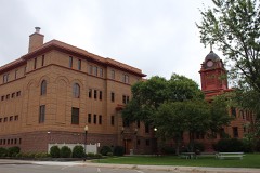 | Beltrami County Courthouse | building | 1988 | 88000665 |
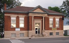 | Bemidji Carnegie Library | building | 1980 | 80001936 |
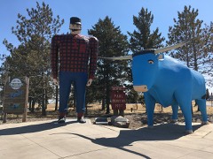 | Bunyan, Paul, and Babe the Blue Ox | object | 1988 | 88000204 |
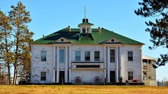 | District No. 132 School | building | 1988 | 88002083 |
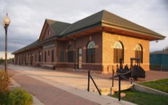 | Great Northern Depot | building | 1988 | 88000673 |
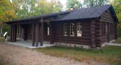 | Lake Bemidji State Park CCC/NYA/Rustic Style Historic Resources | district | 1989 | 89001674 |
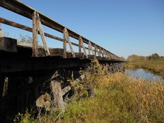 | Minnesota and International Railway Trestle at Blackduck | structure | 2014 | 13001144 |
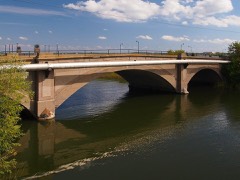 | Nymore Bridge | structure | 1989 | 89001849 |
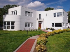 | Park, David, House | building | 1988 | 88000566 |
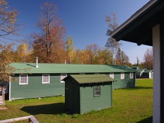 | Rabideau Civilian Conservation Corps (CCC) Camp | district | 1976 | 76001046 |
| Saum Schools | building | 1980 | 80001937 |
Every wildfire the federal occurrence database records inside this county: 11,905 of them, burning about 190,149 acres. 18 started naturally and 2,690 were recorded as arson. Each settlement page carries the fires within five miles of it.
| Reported cause | Fires |
|---|---|
| Debris and open burning | 3668 |
| Misuse of fire by a minor | 2772 |
| Arson/incendiarism | 2690 |
| Missing data/not specified/undetermined | 2413 |
| Recreation and ceremony | 120 |
| Equipment and vehicle use | 111 |
| Fireworks | 48 |
| Smoking | 32 |
| Natural | 18 |
| Railroad operations and maintenance | 12 |
| Other causes | 11 |
| Power generation/transmission/distribution | 10 |
The five largest, by the area the report gives. Three of them were set deliberately.
| Date | Cause | Size | Reported by | Name on the report |
|---|---|---|---|---|
| 9 April 2003 | Debris and open burning | 38,753 acres | Red Lake Agency | RL257 |
| 30 September 2012 | Missing data/not specified/undetermined | 25,396 acres | Minnesota Department of Natural Resources | NORTH MINNIE |
| 29 April 2001 | Arson/incendiarism | 13,820 acres | Red Lake Agency | RL215 |
| 23 April 1994 | Arson/incendiarism | 11,420 acres | Red Lake Agency | not named |
| 16 March 1998 | Debris and open burning | 6,000 acres | Red Lake Agency | RL3 |
| 11 April 2007 | Debris and open burning | 5,157 acres | Red Lake Agency | RL005 |
| 13 May 2013 | Arson/incendiarism | 4,900 acres | Red Lake Agency | RL 156 |
| 30 April 2007 | Debris and open burning | 4,700 acres | Red Lake Agency | RL197 |
Every settlement page carries the fires within five miles of it - see the settlement index below.
The NOAA Storm Events Database holds 615 reports for this county, causing no deaths, no injuries and about $18,646,050 in recorded property damage. Each settlement page carries the reports that name it.
| Kind of event | Reports |
|---|---|
| Hail | 311 |
| Thunderstorm Wind | 234 |
| Tornado | 44 |
| Flash Flood | 13 |
| Funnel Cloud | 6 |
| Flood | 4 |
| Lightning | 3 |
The most serious of them, by death, then injury, then recorded damage. The accounts are quoted exactly as the forecast office filed them.
| When | Event | Place named | Harm | What the report says |
|---|---|---|---|---|
| June 2025 | Thunderstorm Wind | Solway | $15,000,000 | A ground survey and high resolution satellite confirmed a swath of destructive straight-line winds estimated between 80-120 mph occurred across southern Beltrami County. The swath started in Clearwater County and continued east across southern Beltrami County and northern Hubbard County, and was approximately 30 miles long. The widest part of the swath was approximately 12 miles wide from just north of Bemidji to its southernmost point in northern Hubbard County. There was approximately 143,838 acres of southern Beltrami County impacted with widespread tree damage within this single swath. Highest impacted areas extend from near the US Highway 2 and Division Street West intersection, through downtown Bemidji, and through southern and eastern areas of Lake Bemidji. Extensive and significant tree damage was noted within this swath. While widespread tree damage occurred across this 30 mile long swath, the most significant tree damage was within a mile swath beginning south of Wilton and extending about 4 miles east of Lake Bemidji. Such widespread and significant tree damage made numerous roads inaccessible, hampering recovery efforts and trapping people at locations like Lake Bemidji State Park. Some trees that were downed are reported to be 100 to 200 years old. As a result of extensive tree damage, widespread and long duration power outages occurred for over 50,000 reported accounts, some locations lasting more than 6 days after the event within Beltrami County near the Bemidji area. Fallen trees also resulted in vehicular and structural damage. Widespread structural damage from destructive winds alone also occurred to residential and commercial buildings, government buildings, the Sanford Center Arena, and Bemidji State University. This includes, but is not limited to, completely destroyed outbuildings and garages, roofs damaged or completely destroyed, and numerous instances of broken windows. Reports of damage to aircraft and airport buildings received at the Bemidji International Airport. Media relayed that 90 percent of Bemidji State University buildings suffered some form of damage. NWS storm survey teams did not find definitive evidence of tornadic circulation, rather they found damage indicative of destructive straight line winds. |
| July 2021 | Tornado (EF1) | Redlake | $1,200,000 | Initial report of a tornado on Lower Red Lake, which moved onshore at Red Lake and tracked for less than one mile. The tornado lifted by 515 PM CDT. Damaging downburst winds, heavy rain, and large hail continued to track southeastward with this storm. Damage was reported to the Tribal College, as well as other homes and buildings in the area. A light pole was snapped and several signs were toppled. Several large trees were snapped. |
| July 2021 | Tornado (EF1) | Redby | $500,000 | This tornado formed near the shore of Lower Red Lake and tracked to the southeast. It crossed MN HWY 1 near the intersection with BIA15 and penetrated deeply into a large evergreen and oak forest. Trees were snapped and debris was tangled, though most debris tracked with the southeast moving storm. The tornado appeared to have dissipated around 522 PM CDT, after crossing BIA18, roughly 6 miles ESE of Redby. |
| June 2008 | Hail | Bemidji | $400,000 | Golf ball size hail fell for about four minutes from 6:00 PM to 6:04 PM. |
| July 2018 | Tornado (EF1) | Bemidji | $250,000 | The tornado occurred west of Bemidji State University. A garage was lifted off its foundation, trees were snapped or uprooted, and several roofs were damaged. Projectiles damaged many windows in the area. Flying debris damaged light poles and street signs in the area. |
| April 1974 | Tornado (F1) | not stated | $250,000 | no account filed |
| July 2021 | Tornado (EF0) | Nebish | $100,000 | This tornado was likely wrapped in downburst winds, heavy rain, and large ail. The tornado crossed several County and Township roads as it tracked to the southeast, with numerous poplar and oak trees snapped along it's path. It appears to have crossed portions of Dark Lake, Whitefish Lake, and Sandy Lake in Nebish and Hagali Townships, before dissipating. near the western edge of Gull Lake, about 4 WNW of Tenstrike. |
| July 2018 | Tornado (EF1) | Saum | $100,000 | Reports of this tornado, along with video, were posted to social media, showing contact and an eastward track beginning over open water on Lower Red Lake. The tornado tracked onshore about four miles north-northwest of Battle River, and continued on an intermittent east-northeast track for nearly five miles, crossing Beltrami County 23 about four miles north of Saum. Large poplar and pine trees were snapped or uprooted along the damage path. Peak winds were estimated at 100 mph. |
| July 2017 | Tornado (EF1) | Saum | $100,000 | This tornado tracked eastward with numerous intermittent touchdowns along its roughly three mile track. Numerous trees were snapped and a couple of grain bins were toppled. Roof panels and walls were blown out of pole sheds and calving sheds were flipped. Insulation and roofing metal were strewn about. Peak winds were estimated at 95 mph. |
| July 1996 | Hail | Bemidji | $100,000 | no account filed |
| July 1996 | Hail | Bemidji | $100,000 | no account filed |
| June 1999 | Flash Flood | Bemidji | $50,000 | Rapid flooding washed out a driveway and flooded several roads. |
| July 1999 | Hail | Bemidji | $50,000 | Car dealerships suffered a lot of damage from the hail. |
| July 2008 | Thunderstorm Wind | Lavinia | $40,000 | Trees were blown onto power lines and a boat was flipped on Lake Andrusia. |
| August 2001 | Thunderstorm Wind | Bemidji | $25,000 | Many trees were blown down at Lake Bemidji State Park. One tree fell on a car and another damaged a camper. |
| July 2001 | Thunderstorm Wind | Tenstrike | $25,000 | Boats and docks were damaged. |
| August 1978 | Tornado (F1) | not stated | $25,000 | no account filed |
| July 2018 | Tornado (EF0) | Ponemah | $20,000 | Reports of this tornado, along with video, were posted to social media. The tornado touched down just off the shore, over Lower Red Lake. It moved on shore roughly two miles west of Ponemah and continued to track to the east-northeast, for another mile or so, before dissipating. Large poplar and ash tree limbs were broken down along this path. Peak winds were estimated at 80 mph. |
| July 2018 | Tornado (EF1) | Ponemah | $20,000 | This tornado touched down and tracked along and across the Bureau of Indian Affairs (BIA) 25 road for about two miles, to near the south shore of the Lower Red Lake. Trees were torn up quite violently and debris was spread across nearly a mile of BIA25. Peak winds were estimated at 100 mph. |
| June 2016 | Lightning | Scribner | $20,000 | A lightning strike set a barn on fire. |
| July 2008 | Thunderstorm Wind | Shooks | $20,000 | Very strong winds were observed along with wind driven hail. |
| June 1999 | Thunderstorm Wind | Bemidji | $20,000 | Strong winds blew over 4 interior block walls at the construction site for the new Bemidji High School. The walls were tethered to the ground with cables. |
| June 2014 | Flood | Waskish | $20,000 | no account filed |
| June 2022 | Tornado (EF1) | Solway | $15,000 | Thunderstorm cell merger helped to initiate a tornado which then tracked to the north-northeast. The fast developing funnel cloud was viewed by local spotters prior to sheltering. Subsequent survey found numerous large poplar and pine trees were snapped and a few were uprooted, in a loose swirl or converging pattern, all along a nearly 4 mile long path. Power lines were taken down in spots due to snapped trees. |
| August 2001 | Thunderstorm Wind | Bemidji | $15,000 | A tree fell on a garage, completely destroying it. |
| May 2012 | Thunderstorm Wind | Lavinia | $10,000 | A 100 yard row of trees were flattened from south to north. The area impacted was along Roosevelt Road just west of School Lake. |
| September 2004 | Lightning | Bemidji | $10,000 | A lightning strike ignited a small fire in the attic of a house. |
| July 2001 | Flash Flood | Fourtown | $10,000 | Roads and basements were flooded and several homes were surrounded by water. 7 1/2 inches of rain was reported. |
| July 1999 | Thunderstorm Wind | Bemidji | $10,000 | A tree fell on a motorhome in Bemidji. |
| June 1997 | Thunderstorm Wind | Waskish | $10,000 | Numerous large trees were blown over. |
| May 1996 | Thunderstorm Wind | Solway | $10,000 | no account filed |
| May 1996 | Thunderstorm Wind | Bemidji | $10,000 | no account filed |
| May 2009 | Thunderstorm Wind | Blackduck | $8,000 | A small utility shed was blown down near Blackduck Lake. |
| August 2011 | Flash Flood | Bemidji | $5,000 | Several streets south of downtown Bemidji had 1 to 2 feet of water flowing in them and at least one car was stranded. |
| July 2009 | Thunderstorm Wind | Blackduck | $5,000 | A boat with four occupants aboard overturned on Blackduck Lake, due to a combination of factors. The lake was rough at the time, but weather was not the main issue. However, thunderstorm winds did hamper rescue efforts following the accident. Two of the occupants were rescued but two others drowned. |
| July 2008 | Hail | Puposky | $5,000 | Nickel to quarter sized hail fell. |
| July 2008 | Thunderstorm Wind | Waskish | $5,000 | Several 2 to 3 inch diameter branches were blown down along with one 10 inch diameter apple tree. |
| July 2003 | Thunderstorm Wind | Kelliher | $5,000 | Roofing material was blown off the Kelliher Cafe. Several large trees were also blown down. |
| September 2002 | Thunderstorm Wind | Fourtown | $5,000 | Numerous large trees were snapped off or uprooted in the Beltrami Island State Forest. |
| August 2001 | Thunderstorm Wind | Fourtown | $5,000 | Trees and powerlines were blown down. |
| July 1998 | Thunderstorm Wind | Hines | $5,000 | Power lines were blown down at Hines. |
| June 1997 | Thunderstorm Wind | Bemidji | $5,000 | Several large trees were blown down. |
| June 1997 | Thunderstorm Wind | Grygla | $5,000 | Strong wind knocked down several large trees. |
| May 2013 | Flood | Debs | $5,000 | no account filed |
| April 2013 | Flood | Debs | $5,000 | no account filed |
| March 2009 | Flood | Malcolm | $5,000 | no account filed |
| May 1996 | Thunderstorm Wind | Bemidji | $5,000 | no account filed |
| May 1996 | Thunderstorm Wind | Bemidji | $5,000 | no account filed |
| August 1996 | Thunderstorm Wind | Turtle River | $5,000 | no account filed |
| August 2001 | Thunderstorm Wind | (Bji)Bemidji Arpt | $3,000 | Trees were blown down, knocking out the power to the Bemidji AWOS. |
| September 1964 | Tornado (F1) | not stated | $2,500 | no account filed |
| August 2009 | Thunderstorm Wind | Waskish | $2,000 | Multiple trees approximately 10 to 20 inches in diameter were uprooted or snapped. An old trailer was also damaged. An empty 450 gallon water tank was thrown about 100 yards over two fences and into a ditch. Crops were also damaged in the same area. |
| July 2001 | Thunderstorm Wind | Redby | $2,000 | Trees were blown down along highway 1. |
| July 2001 | Flash Flood | Thorhult | $2,000 | Ditches overflowed onto county roads. |
| July 2001 | Thunderstorm Wind | Waskish | $2,000 | Trees were blown down by the strong wind. |
| July 1999 | Thunderstorm Wind | Blackduck | $2,000 | Significant tree damage was reported southwest of Blackduck. At Blackduck Lake, a car and camper were damaged by falling trees. |
| August 2001 | Thunderstorm Wind | Tenstrike | $1,000 | Branches were blown down. |
| July 2001 | Thunderstorm Wind | Fourtown | $1,000 | Trees were blown down. |
| August 2001 | Thunderstorm Wind | Waskish | $1,000 | Trees were blown down onto highway 72. |
| July 1999 | Thunderstorm Wind | Blackduck | $1,000 | Large trees were damaged by the wind. |
The Survey's mineral resources record lists 21 workings inside this county. 10 still produce and 11 are closed or unrecorded. Each settlement page carries the workings within five miles of it.
| Commodity | Workings |
|---|---|
| Sand and Gravel, Construction | 15 |
| Limestone, General | 3 |
| Peat | 1 |
| Gold | 1 |
| Clay | 1 |
The least common of them first, because a county's hundredth gravel pit says nothing its first ten did not.
| Where | Site | Commodity | Status | Recorded |
|---|---|---|---|---|
| Beltrami County Clay Deposit | Clay | Occurrence | ||
| Beltrami County Peat Bogs | Peat | Occurrence | ||
| Kelliher Prospect | Gold | Unknown | Gold | |
| Beltrami County Marl Beds No 1 | Limestone, General | Occurrence | ||
| Beltrami County Marl Beds No 2 | Limestone, General | Occurrence | ||
| Beltrami County Marl Beds No 3 | Limestone, General | Occurrence | ||
| Barthelemy Pit | Sand and Gravel, Construction | Past Producer | ||
| Beighley Bros Pit | Sand and Gravel, Construction | Producer | ||
| Bemidji Blacktop Pit | Sand and Gravel, Construction | Past Producer | ||
| County Pit | Sand and Gravel, Construction | Producer | ||
| Jerome Pit and Plant | Sand and Gravel, Construction | Producer | ||
| Kelly Pit | Sand and Gravel, Construction | Producer | ||
| Miller Pit and Mill | Sand and Gravel, Construction | Producer | ||
| Opsahl Pit & Mill | Sand and Gravel, Construction | Producer | ||
| Ray Pit and Mill | Sand and Gravel, Construction | Producer | ||
| Tenstrike Pit | Sand and Gravel, Construction | Past Producer | ||
| Thomas Pit | Sand and Gravel, Construction | Producer | ||
| Thorson Pit No 1 | Sand and Gravel, Construction | Past Producer | ||
| Thorson Pit No 2 | Sand and Gravel, Construction | Past Producer | ||
| Wash Plant | Sand and Gravel, Construction | Producer | ||
| Whitting Pit & Mill | Sand and Gravel, Construction | Producer |
Named settlements recorded in the Geographic Names Information System, each with the topographic sheets covering it. Villages, hamlets and abandoned places alike. Each is shown with the nearest named watercourse or landform and the survey quadrangle it falls on.
North Beltrami unorganized territory · 56727 · Gates Corner quadrangle
7 sheets, 1918 to 1977
Lower Red Lake unorganized territory · 56671 · On Little Rock Creek · Red Lake quadrangle
9 sheets, 1954 to 1985
Brook Lake unorganized territory · 56663 · On Sucker Creek · Pennington quadrangle
9 sheets, 1954 to 1996
Quiring township · 56630 · On South Cormorant River · Saum quadrangle
9 sheets, 1919 to 1976
Lower Red Lake unorganized territory · 56671 · On Pike Creek · Red Lake OE N quadrangle
8 sheets, 1954 to 1985
Lower Red Lake unorganized territory · 56670 · On Mud River · Redby OE N quadrangle
7 sheets, 1954 to 1976