BlockBefore
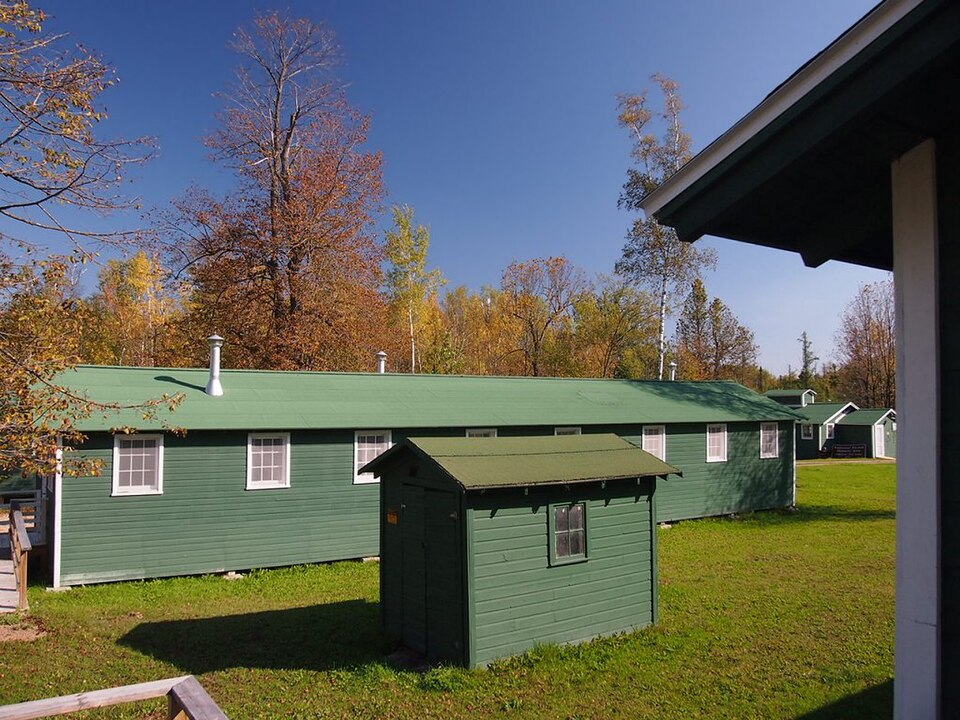
Photograph of Rabideau CCC Camp
Photograph by McGhiever, CC BY-SA 3.0. Via Wikimedia Commons.

Rabideau Civilian Conservation Corps (CCC) Camp

A National Historic Landmark. Listed on the National Register of Historic Places in 1976.

From the record

One of 11 National Register listings published here for Beltrami County · listed in 1976 · category: District · a National Historic Landmark.

Sources: the case file at the National Archives · the National Register database, National Park Service · the Wikipedia article

The listing

  • National Historic Landmark. The highest federal designation, held by about 2,600 places in the country against roughly 100,000 Register listings.
  • What is counted as historic. The nomination lists 12 buildingss, 3 structuress, 2 sitess as contributing to the listing.
  • Address. Off Co. Hwy. 39 in Chippewa National Forest, Taylor Township, Blackduck, 56647
  • When was it listed? June 1976
  • Category. district
  • Township. Taylor township
  • Architectural style. rustic architecture
  • National Register reference number. 76001046 - the number the National Park Service assigned this property when it was listed, and the key its nomination file is catalogued under at the National Archives.

Fires near this property

29 since 1993

Regional context, not property-specific evidence. The federal wildfire occurrence database lists 29 fires within 5 miles of Rabideau Civilian Conservation Corps (CCC) Camp between 1993 and 2019, burning about 53 acres in total. None started naturally. 8 were recorded as arson. Distance is straight-line from the map coordinates, so a fire counted here may appear on a neighbouring settlement's page as well.

Reported cause Fires
Debris and open burning13
Arson/incendiarism8
Equipment and vehicle use2
Missing data/not specified/undetermined2
Power generation/transmission/distribution2
Railroad operations and maintenance1
Recreation and ceremony1

The most recent of them, most recent first, with the day each was reported and the service that recorded it.

DateCause SizeReported by Name on the report
25 September 2001Equipment and vehicle useunder an acreChippewa National ForestHYDROAX FIRE
6 July 2006Debris and open burningunder an acreChippewa National ForestRICE POND
3 July 2006Arson/incendiarismunder an acreChippewa National ForestSTUMP
16 July 2010Equipment and vehicle useunder an acreChippewa National ForestTWIN
6 May 1996Arson/incendiarismunder an acreChippewa National ForestHINES SPUR 3
6 May 1996Arson/incendiarismunder an acreChippewa National ForestHINES SPUR 2
6 May 1996Arson/incendiarismunder an acreChippewa National ForestHINES SPUR 1
5 May 1996Debris and open burning5.0 acresChippewa National ForestSWEDBERG

Every fire recorded in Beltrami County

Mines and quarries near this property

1 within 5 miles

Regional context, not property-specific evidence. The federal mineral resources record lists 1 working within 5 miles of Rabideau Civilian Conservation Corps (CCC) Camp: 1 producer. All of them still produce. What was taken out: Sand and Gravel, Construction. Distance is straight-line from the map coordinates, so a quarry counted here may appear on a neighbouring settlement's page as well.

Where SiteCommodity StatusRecorded
Beighley Bros PitSand and Gravel, ConstructionProducer

Every working recorded in Beltrami County

Storms near this property

38 since 1994

Regional context, not property-specific evidence. The National Weather Service names Blackduck, the town this property stands in, in 38 storm reports between 1994 and 2024: 22 hail, 15 thunderstorm wind, 1 tornado. No death or injury is recorded in these reports. Each account below is quoted exactly as the forecast office filed it, from the NOAA Storm Events Database, and each date opens the federal record of that event.

WhenEvent Place namedHarm What the report says
May 2009Thunderstorm WindBlackduck$8,000A small utility shed was blown down near Blackduck Lake.
July 2009Thunderstorm WindBlackduck$5,000A boat with four occupants aboard overturned on Blackduck Lake, due to a combination of factors. The lake was rough at the time, but weather was not the main issue. However, thunderstorm winds did hamper rescue efforts following the accident. Two of the occupants were rescued but two others drowned.
July 1999Thunderstorm WindBlackduck$2,000Significant tree damage was reported southwest of Blackduck. At Blackduck Lake, a car and camper were damaged by falling trees.
July 1999Thunderstorm WindBlackduck$1,000Large trees were damaged by the wind.
August 2024HailBlackduck-Emergency Manager reports golf ball sized hail in Blackduck, MN.
August 2024HailBlackduck-Trained spotter reports quarter sized hail. Lasted 5 minutes, and garden was damaged.
May 2023HailBlackduck-Corrects previous hail report from 2 NE Blackduck. 1 - 1.25 inch hail.
June 2022Thunderstorm WindBlackduck-Several large tree branches were down. Power lines down. Time is estimated based on local wind sensor reports prior to the reported power outages.
July 2022Thunderstorm WindBlackduck-A pine tree was snapped at Dunrovin resort. Report and photo was posted via social media. Time estimated based on radar and nearby wind sensors.
September 2021HailBlackduck-Hail ranged from dimes to quarters and was accompanied by brief heavy rain and very strong winds.
July 2021HailBlackduck-Small hail covered the ground, with quarter sized hail mixed in. Hail fell for about 1 to 2 minutes across portions of southeastern Langor Township.
July 2021HailBlackduck-Golf ball sized hail reported at the Blackduck golf course. Damaging winds and large hail occurred across most of the Blackduck Lake area and Hines Township from 530 PM CDT to 540 PM CDT.
June 2018Thunderstorm WindBlackduck-Multiple trees were blown down between Blackduck and Kelliher.
July 2014HailBlackduck-The hail fell on the north shore of Blackduck Lake.
August 2013Thunderstorm WindBlackduck-Very strong winds and pea sized hail were reported on the north shore of Blackduck Lake.
August 2013Thunderstorm WindBlackduck-Shingles were blown off of multiple structures and a steeple was blown off a church.
July 2011HailBlackduck-A few dime to quarter sized hailstones fell along with heavy rain and very strong winds.
July 2011Thunderstorm WindBlackduck-A spotter reported 70 mph winds west of Blackduck.
June 2007Thunderstorm WindBlackduck-Many trees were blown down. Scattered electrical outages were also reported.
July 2006Thunderstorm WindBlackduck-A few birch trees were blown over and several large branches were broken off of evergreens along the east end of Rabideau Lake.
June 2005Tornado (F1)Blackduck-The tornado tracked through trees and crossed scenic highway 39 south of Blackduck. Many large trees were knocked down along the damage path. Peak wind speeds were estimated at 100 mph.
June 2005Thunderstorm WindBlackduck-A sheriff's deputy reported trees bent over and blinding rain.
June 1994Thunderstorm WindBlackduck-Strong thunderstorm winds blew over two small campers and lifted the roof from a building. Shingles were also blown from the roofs of a number of area homes.
July 2014HailBlackduck-no account filed
July 2011HailBlackduck-no account filed
May 2009HailBlackduck-no account filed
June 2007HailBlackduck-no account filed
August 2004HailBlackduck-no account filed
July 2003Thunderstorm WindBlackduck-no account filed
May 2001HailBlackduck-no account filed
July 2000HailBlackduck-no account filed
June 1999HailBlackduck-no account filed
July 1999HailBlackduck-no account filed
June 1997HailBlackduck-no account filed

Every storm recorded in Beltrami County

Map coverage status

No historic map-sheet match is published for this property yet. That does not mean no map exists. This record needs a coordinate-quality review before it can be joined to a sheet boundary. Browse the county's mapped places while that work is pending.

Listed places nearby

1 within 8 miles

Other National Register properties close enough to walk or drive between, ordered by distance from this one. Both positions come from the same geocoding pass that matched these properties to their map sheets.

Photograph PropertyDistance Listed
Minnesota and International Railway Trestle at Blackduck6.1 miles2014

Sources for this property

National Archives recordThe nomination case file for reference 76001046 in Record Group 79.
Wikipedia articleCommunity-written account of this property, licensed CC BY-SA.
Beltrami CountyAll 11 listed properties in this county.

Provenance

  • Listing record. National Park Service National Register of Historic Places, listed-properties dataset, current to 2026-05-22.
  • Map join. Address geocoded through the United States Census geocoder, then tested against the published boundary of every sheet in the USGS Historical Topographic Map Collection.
  • How this page is made. Listing fields come from federal records; map-sheet coverage is a labelled coordinate-to-boundary calculation, not a source-field claim.
  • Wildfire. Short, Karen C. 2022. Spatial wildfire occurrence data for the United States, 1992-2020 [FPA_FOD_20221014]. 6th Edition. Fort Collins, CO: Forest Service Research Data Archive. https://doi.org/10.2737/RDS-2013-0009.6 Collected with United States Government funding and usable without additional permissions or fees.
  • Mines and quarries. USGS Mineral Resources Data System (MRDS) https://mrdata.usgs.gov/mrds/ A work of the United States government, no copyright under 17 U.S.C. 105.
  • Storms. NOAA National Centers for Environmental Information, Storm Events Database https://www.ncei.noaa.gov/stormevents/ A work of the United States government, no copyright under 17 U.S.C. 105. Narratives are quoted verbatim from the National Weather Service report and are not edited or summarised.