 Block
From the record
15 National Register listings published here, 1 of them a National Historic Landmark.
Sources: the National Register database, National Park Service
54 topographic sheets cover 31 settlements here, and 15 properties are on the National Register of Historic Places.
15 National Register listings published here, 1 of them a National Historic Landmark.
Sources: the National Register database, National Park Service
Every property in this county listed on the National Register of Historic Places, with the year it was listed and the federal nomination document.
| Photograph | Property | Type | Listed | Reference |
|---|---|---|---|---|
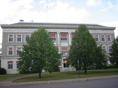 | Carlton County Courthouse | building | 1985 | 85001926 |
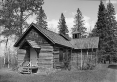 | Church of Sts. Joseph and Mary-Catholic | building | 1984 | 84001409 |
 | Cloquet City Hall | building | 1985 | 85002312 |
| Cloquet High School | building | 2021 | 100006356 | |
 | Cloquet-Northern Office Building | building | 1985 | 85001925 |
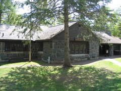 | Jay Cooke State Park CCC/Rustic Style Historic District | district | 1992 | 89001665 |
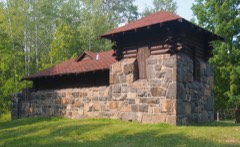 | Jay Cooke State Park CCC/WPA/Rustic Style Picnic Grounds | district | 1992 | 92000640 |
| Jay Cooke State Park CCC/WPA/Rustic Style Service Yard | district | 1992 | 92000642 | |
| Grand Portage of the St. Louis River | site | 1973 | 73000966 | |
| Lindholm Oil Company Service Station | building | 1985 | 85002202 | |
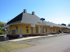 | Minneapolis, St. Paul, and Sault Ste. Marie Depot | building | 1994 | 86003813 |
 | Northeastern Hotel | building | 1984 | 84000218 |
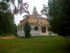 | Henry C. Oldenburg House | building | 2006 | 06001183 |
| Park Place Historic District | district | 1985 | 85001924 | |
 | Shaw Memorial Library | building | 1985 | 85001927 |
Every wildfire the federal occurrence database records inside this county: 1,332 of them, burning about 2,530 acres. 18 started naturally and 165 were recorded as arson. Each settlement page carries the fires within five miles of it.
| Reported cause | Fires |
|---|---|
| Debris and open burning | 481 |
| Missing data/not specified/undetermined | 183 |
| Railroad operations and maintenance | 166 |
| Arson/incendiarism | 165 |
| Equipment and vehicle use | 154 |
| Recreation and ceremony | 53 |
| Smoking | 49 |
| Misuse of fire by a minor | 26 |
| Power generation/transmission/distribution | 21 |
| Natural | 18 |
| Fireworks | 8 |
| Other causes | 7 |
| Firearms and explosives use | 1 |
The five largest, by the area the report gives. Three of them were set deliberately.
| Date | Cause | Size | Reported by | Name on the report |
|---|---|---|---|---|
| 20 May 1994 | Arson/incendiarism | 110 acres | Minnesota Department of Natural Resources | not named |
| 17 May 1995 | Arson/incendiarism | 109 acres | Minnesota Department of Natural Resources | not named |
| 29 April 1996 | Debris and open burning | 100 acres | Minnesota Department of Natural Resources | not named |
| 13 April 2003 | Arson/incendiarism | 97 acres | Fond Du Lac Tribe | 2ND BRIDGE |
| 23 June 2008 | Missing data/not specified/undetermined | 75 acres | Minnesota Department of Natural Resources | not named |
| 23 March 2010 | Debris and open burning | 62 acres | Minnesota Department of Natural Resources | not named |
| 3 April 2005 | Debris and open burning | 53 acres | Minnesota Department of Natural Resources | not named |
| 5 March 2000 | Debris and open burning | 47 acres | Minnesota Department of Natural Resources | not named |
Every settlement page carries the fires within five miles of it - see the settlement index below.
The NOAA Storm Events Database holds 267 reports for this county, causing no deaths, 2 injuries and about $42,190,500 in recorded property damage. Each settlement page carries the reports that name it.
| Kind of event | Reports |
|---|---|
| Hail | 126 |
| Thunderstorm Wind | 105 |
| Flash Flood | 18 |
| Tornado | 9 |
| Lightning | 5 |
| Flood | 4 |
The most serious of them, by death, then injury, then recorded damage. The accounts are quoted exactly as the forecast office filed them.
| When | Event | Place named | Harm | What the report says |
|---|---|---|---|---|
| July 1970 | Tornado (F2) | not stated | 2 hurt, $250,000 | no account filed |
| June 2012 | Flash Flood | Esko | $20,000,000 | Jay Cooke State Park was evacuated due to severe flooding of the St. Louis River.|Highway 210 through the park was heavily damage. The historic swinging pedestrian bridge was washed away. Miles of hiking and biking trails were damaged. |
| June 2012 | Flood | Moose Lake | $16,000,000 | Moose Head Lake in Moose Lake overflowed its banks after the area received 6 to 8 inches of rain, flooding 30 percent of the town. One hundred and fifty homes were flooded. The schools were flooded. The town's water and sewer system were compromised. |
| June 2012 | Flood | Carlton | $3,000,000 | Flooding of the St Louis River began at the Scanlon gage at 1:30 AM CST on June 20th when it reached a level of 10.50 feet. The St Louis River reached a record-breaking crest of 16.66 feet at 3 am CST on June 21. The St Louis River returned below its flood stage of 10.50 feet on June 28th at 10:00 AM CST. Businesses and a campground near the river were flooded. |
| June 2012 | Flash Flood | Esko | $2,000,000 | The reservoir at the City of Thomson overflowed and Carlton County Emergency Management ordered the evacuation of Thomson. Most of the town was flooded. The water remained for many days. Many homes were lost or severely damaged. |
| June 2002 | Lightning | Cloquet | $500,000 | no account filed |
| August 2007 | Lightning | Cloquet | $120,000 | A lightning bolt caused considerable roof and structural damage to the Queen of Peace Catholic Church. Damage to the electrical, phone, and public address system was also noted. |
| April 2025 | Lightning | Scanlon | $75,000 | The Cloquet Are Fire District responded to a report of a house struck by lightning with snow inside the home on Washington Street. Fire crews found significant damage to both the interior and exterior of the home likely caused by the lightning strike. Damage was also found in the adjacent yard further pointing to a lightning strike. No injuries were reported. |
| June 2024 | Tornado (EF0) | Wright | $50,000 | Tornado developed on or near the Aitkin/Carlton County line and traveled southeast towards Highway 210 between Wright and Cromwell. Minor tree damage was noted on West Road near the start of the tornado path, with a broad area of large branches down and a few trees snapped towards the top. The tornado then traveled across a mainly marsh/bog landscape, crossing Center Road where power lines were damaged and widespread tree damage was noted along a 50 yard stretch of road. The tornado track continued on a southeast to east-southeast path, with the last signs of damage near to just south of Highway 210 near Woodbury Lake where a few clusters of tree damage were noted. No injuries or fatalities were reported, and property damage was very limited, with only a handful of homes/buildings impacted. |
| September 2024 | Hail | Mahtowa | $30,000 | Cars were damaged on Interstate 35 near the Mahtowa exit. |
| August 2011 | Lightning | Harney | $30,000 | Lightning struck tree, which fell onto a house, waking the occupants. |
| June 1976 | Tornado (F1) | not stated | $25,000 | no account filed |
| July 1973 | Tornado (F1) | not stated | $25,000 | no account filed |
| June 1967 | Tornado (F0) | not stated | $25,000 | no account filed |
| June 2024 | Flash Flood | Automba | $20,000 | A few roads were washed out by the heavy rainfall just south of Automba on CR 135 and near the intersection of CR 135 and CR12. Water was quickly receding. |
| July 2023 | Lightning | Atkinson | $20,000 | Lightning struck a 100-year-old barn in Blackhoof Township leading to a fire that completely destroyed the barn. No injuries or fatalities were reported and no other structures were impacted, but the barn was a total loss. |
| July 2010 | Thunderstorm Wind | Cloquet | $4,000 | Power lines and trees were blown down in and around Cloquet. Many small tree limbs were also blown down. |
| June 1986 | Tornado (F1) | not stated | $2,500 | no account filed |
| June 1986 | Tornado (F1) | not stated | $2,500 | no account filed |
| July 2010 | Thunderstorm Wind | Cromwell | $2,000 | Trees were blown down onto Minnesota Highway 73. |
| July 2010 | Thunderstorm Wind | Cloquet | $2,000 | Trees were blown down in and around Cloquet, including a 40-foot pine tree. |
| July 2010 | Thunderstorm Wind | Cloquet | $2,000 | Large trees were blown down near Big Lake. |
| July 2010 | Thunderstorm Wind | Cloquet | $2,000 | The top of a spruce tree was snapped off, four large basswood trees were blown down, and a couple of tent poles were broken. The damage occurred near Big Lake. |
| July 1995 | Thunderstorm Wind | Moose Lake | $2,000 | no account filed |
| July 2010 | Thunderstorm Wind | Scanlon | $1,000 | Trees were blown down. |
| July 2010 | Thunderstorm Wind | Cloquet | $500 | A 12-inch diameter tree was blown down across a road. |
| March 2025 | Hail | Mahtowa | - | Dimes to quarter sized hail with over an inch of accumulation on the ground. |
| July 2025 | Thunderstorm Wind | Blackhoof | - | Multiple trees and a flagpole were downed at the reporter's location. |
| June 2024 | Thunderstorm Wind | Automba | - | A large, healthy, old maple tree was snapped and fell onto a powerline along with a 2 foot diameter pine that was uprooted and toppled in the storm across CR135 in the area as well. |
| July 2024 | Thunderstorm Wind | Kettle River | - | Branches were reported down along with a mature pine tree down across a road on the north side of town. |
| July 2024 | Thunderstorm Wind | Wrenshall | - | A tree was reported down near the Wrenshall city hall. |
| July 2024 | Thunderstorm Wind | Iverson | - | A tree fell onto a parked car just west of the Black Bear Casino. |
| June 2024 | Thunderstorm Wind | Cloquet | - | A large, healthy tee was down on the north side of Cloquet onto a fence causing damage to the fence. |
| June 2024 | Thunderstorm Wind | Wright | - | A tree at least 18 inches in diameter was down blocking a lane of Highway 210. |
| May 2023 | Hail | Ronald | - | A photo was received showing hail piles taken after sunrise. The largest stones were nickel-sized and were most likely larger when they fell some 4-5 hours earlier. |
| August 2023 | Thunderstorm Wind | Esko | - | Tree debris was partially blocking the Esko exit off Interstate 35. Additionally, two larger trees about 12 inches in diameter were down nearby. |
| May 2022 | Thunderstorm Wind | Holyoke | - | A few tree limbs were broken. |
| May 2022 | Thunderstorm Wind | Kettle River | - | Trees of 4, 5 and 8 inches in diameter were blown down over Highway 73 south of Kettle River. |
| June 2022 | Thunderstorm Wind | Carlton | - | Winds lofted a trampoline across the yard and over a pool. |
| June 2022 | Thunderstorm Wind | Otter Creek | - | Young maple trees were snapped in half. |
| July 2020 | Thunderstorm Wind | Scanlon | - | A tree was downed onto a metal fence. The fence was mostly intact, but the wire portion was dislodged at bent at the point of impact. |
| August 2020 | Thunderstorm Wind | Ronald | - | Multiple 8 inch diameter trees were downed along with an area of flattened corn stalks. |
| August 2020 | Thunderstorm Wind | Scotts Corner | - | A power line was downed by the storm. |
| August 2020 | Thunderstorm Wind | Thomson | - | A pine tree was down across Minnesota Highway 210. |
| August 2020 | Tornado (EF1) | Moose Lake Muni Arpt | - | A tornado tracked north-northwest west of Moose Lake, MN, embedded within a line of thunderstorms. This tornado produced the most significant damage of this severe weather event, damaging multiple properties including lifting the roof off of a two-car garage and destroying at least one metal shed building. There were also pockets of tree damage along the path of the tornado, with numerous trees snapped 10-20 feet above the ground. Damage was strewn across fields, with several two-by-fours driven into the Earth. |
| August 2020 | Tornado (EF0) | Automba | - | A brief radar-confirmed tornado produced a two mile swath of tree damage across mainly forested areas near Automba. No property damage reports were received. The damage path was estimated using satellite imagery and the rating was determined based on other similar damage reports from this event. |
| August 2020 | Thunderstorm Wind | Moose Lake | - | A power line was downed and in a ditch. |
| August 2020 | Thunderstorm Wind | Blackhoof | - | Multiple trees were uprooted by the storm. |
| August 2020 | Thunderstorm Wind | Scotts Corner | - | Over 100 trees were downed by the storm with trees stacked up on each other. |
| August 2020 | Thunderstorm Wind | Esko | - | A tree was downed onto a road in Jay Cooke State Park. |
| August 2020 | Thunderstorm Wind | Scotts Corner | - | A power line was down and across the road. |
| August 2020 | Thunderstorm Wind | Blackhoof | - | A tree was down across a road. |
| June 2019 | Flash Flood | Cloquet | - | The southbound lanes of Minnesota Highway 33 1.5 miles north of Cloquet were beginning to flood and traffic was having to slow to navigate the water on the road. |
| June 2019 | Thunderstorm Wind | Cloquet Crltn Co Arp | - | Multiple trees were downed in Cloquet. |
| June 2018 | Thunderstorm Wind | Cromwell | - | A few trees were blown down by thunderstorm winds. |
| June 2018 | Thunderstorm Wind | Barnum | - | A thunderstorm microburst blew down 30-40 foot tall trees along Interstate 35 both north and south of the Barnum exit. |
| June 2018 | Thunderstorm Wind | Mahtowa | - | Numerous trees were blown down across Highway 61 south of Mahtowa. |
| June 2018 | Thunderstorm Wind | Barnum | - | A large pine tree that was blow down fell on a house. |
| June 2018 | Flash Flood | Frogner | - | Minnesota State Highway 23 was washed out at the Nemadji River Crossing at mile marker 322. |
| June 2018 | Flash Flood | Holyoke | - | Floodwaters washed out a stone culvert on the BNSF Railway railroad tracks, opening up a 300' long and 60' deep hole in the railroad roadbed. The tracks were suspended over the washout. A new steel culvert was built and the tracks were returned to service at midnight on June 22nd. |
The Survey's mineral resources record lists 45 workings inside this county. 30 still produce and 15 are closed or unrecorded. Each settlement page carries the workings within five miles of it.
| Commodity | Workings |
|---|---|
| Sand and Gravel, Construction | 29 |
| Uranium | 9 |
| Clay | 4 |
| Iron | 1 |
| Manganese | 1 |
| Peat | 1 |
| Silica | 1 |
The least common of them first, because a county's hundredth gravel pit says nothing its first ten did not.
| Where | Site | Commodity | Status | Recorded |
|---|---|---|---|---|
| Carlton County Peat Bogs | Peat | Producer | ||
| Carlton County Sand Bed | Silica | Occurrence | ||
| Syracuse Reserve St-4 | Iron, Manganese | Past Producer | Hematite, Magnetite | |
| Carlton County Clay Deposit | Clay | Occurrence | ||
| Nemadji Tile and Pottery Pit No 2 | Clay | Past Producer | ||
| Nemadji Tile and Pottery Pit No 3 | Clay | Past Producer | ||
| Nemadui Tile and Pottery Pit No 1 | Clay | Past Producer | ||
| Uranim Prospect No 8 | Uranium | Occurrence | ||
| Uranium Prospect No 1 | Uranium | Occurrence | ||
| Uranium Prospect No 2 | Uranium | Occurrence | ||
| Uranium Prospect No 3 | Uranium | Occurrence | ||
| Uranium Prospect No 4 | Uranium | Occurrence | ||
| Uranium Prospect No 5 | Uranium | Occurrence | ||
| Uranium Prospect No 6 | Uranium | Occurrence | ||
| Uranium Prospect No 7 | Uranium | Occurrence | ||
| Uranium Prospect No 9 | Uranium | Occurrence | ||
| Airport Pit | Sand and Gravel, Construction | Producer | ||
| Anderson Pit | Sand and Gravel, Construction | Producer | ||
| Angell Pit | Sand and Gravel, Construction | Producer | ||
| Atkinson Pit and Mill | Sand and Gravel, Construction | Producer | ||
| Big Lake Pit | Sand and Gravel, Construction | Producer | ||
| Brandt Pit | Sand and Gravel, Construction | Producer | ||
| Bush Pit | Sand and Gravel, Construction | Producer | ||
| Carter Pit | Sand and Gravel, Construction | Producer | ||
| Cherrie Pit | Sand and Gravel, Construction | Producer | ||
| Conservation Pit | Sand and Gravel, Construction | Producer | ||
| County Pit No 1 | Sand and Gravel, Construction | Producer | ||
| County Pit No 2 | Sand and Gravel, Construction | Producer | ||
| Erickson Pit | Sand and Gravel, Construction | Producer | ||
| G N Lindsay Pit | Sand and Gravel, Construction | Producer | ||
| Hatchery Pit | Sand and Gravel, Construction | Producer | ||
| Heikala Mill | Sand and Gravel, Construction | Producer | ||
| Heikala Pit | Sand and Gravel, Construction | Producer | ||
| Jergonson Pit | Sand and Gravel, Construction | Producer | ||
| Koski Pit | Sand and Gravel, Construction | Producer | ||
| Lindholm Pit | Sand and Gravel, Construction | Producer | ||
| Menghini Pit | Sand and Gravel, Construction | Producer | ||
| Miller Pit | Sand and Gravel, Construction | Producer | ||
| Mueller Sand and Gravel Pit No 2 | Sand and Gravel, Construction | Producer | ||
| Scanlon Pit and Shop | Sand and Gravel, Construction | Producer | ||
| Thompson Twp Pit | Sand and Gravel, Construction | Producer | ||
| Tompson Township Pit | Sand and Gravel, Construction | Producer | ||
| Ulland Bros Pit | Sand and Gravel, Construction | Producer | ||
| Williams Pit | Sand and Gravel, Construction | Producer | ||
| Zacher Pit | Sand and Gravel, Construction | Producer |
Named settlements recorded in the Geographic Names Information System, each with the topographic sheets covering it. Villages, hamlets and abandoned places alike. Each is shown with the nearest named watercourse or landform and the survey quadrangle it falls on.
Barnum city · 55707 · On West Fork Moose Horn River · Barnum quadrangle
7 sheets, 1953 to 1981
North Carlton unorganized territory · 55726 · Cromwell East quadrangle
7 sheets, 1953 to 1982
Moose Lake city · 55767 · On Portage River · Moose Lake quadrangle
7 sheets, 1953 to 1981
Silver township · 55757 · On Dead Moose River · Kettle River quadrangle
7 sheets, 1953 to 1981
Moose Lake city · 55767 · On Portage River · Moose Lake quadrangle
7 sheets, 1953 to 1981
Wrenshall township · 55797 · On Deer Creek · Wrenshall quadrangle
8 sheets, 1953 to 1980