 Block
From the record
8 National Register listings published here.
Sources: the National Register database, National Park Service
33 topographic sheets cover 14 settlements here, and 8 properties are on the National Register of Historic Places.
8 National Register listings published here.
Sources: the National Register database, National Park Service
Every property in this county listed on the National Register of Historic Places, with the year it was listed and the federal nomination document.
| Photograph | Property | Type | Listed | Reference |
|---|---|---|---|---|
 | Charles H. Budd House | building | 1977 | 77000726 |
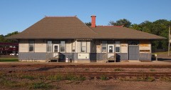 | Chicago, Milwaukee and St. Paul Depot | building | 1988 | 88002079 |
 | Chippewa County Bank | building | 1977 | 77000727 |
| Henry Gippe Farmstead | building | 1985 | 85002558 | |
| Maynard State Bank | building | 2018 | 100002501 | |
 | Montevideo Carnegie Library | building | 1982 | 82002938 |
| Olof Swensson Farmstead | district | 1974 | 74001010 | |
 | Julian A. Weaver House | building | 1986 | 86001344 |
Every wildfire the federal occurrence database records inside this county: 8 of them, burning about 3,349 acres. None started naturally and 3 were recorded as arson. Each settlement page carries the fires within five miles of it.
| Reported cause | Fires |
|---|---|
| Arson/incendiarism | 3 |
| Equipment and vehicle use | 2 |
| Missing data/not specified/undetermined | 1 |
| Railroad operations and maintenance | 1 |
| Debris and open burning | 1 |
The five largest, by the area the report gives. Three of them were set deliberately.
| Date | Cause | Size | Reported by | Name on the report |
|---|---|---|---|---|
| 12 April 2003 | Debris and open burning | 3,191 acres | Minnesota Department of Natural Resources | CHIPPEWA PRAIRIE |
| 11 October 2000 | Equipment and vehicle use | 50 acres | Minnesota Department of Natural Resources | not named |
| 24 March 1992 | Missing data/not specified/undetermined | 46 acres | Litchfield Wetland Management District | RAYMOND |
| 15 April 2010 | Arson/incendiarism | 46 acres | Minnesota Department of Natural Resources | not named |
| 2 March 2000 | Railroad operations and maintenance | 10 acres | Minnesota Department of Natural Resources | not named |
| 5 July 2000 | Arson/incendiarism | 5.0 acres | Minnesota Department of Natural Resources | not named |
| 7 February 2000 | Equipment and vehicle use | under an acre | Minnesota Department of Natural Resources | not named |
| 15 April 2010 | Arson/incendiarism | under an acre | Minnesota Department of Natural Resources | not named |
Every settlement page carries the fires within five miles of it - see the settlement index below.
The NOAA Storm Events Database holds 242 reports for this county, causing no deaths, no injuries and about $7,317,500 in recorded property damage. Each settlement page carries the reports that name it.
| Kind of event | Reports |
|---|---|
| Hail | 106 |
| Thunderstorm Wind | 90 |
| Tornado | 25 |
| Funnel Cloud | 7 |
| Heavy Rain | 5 |
| Flood | 5 |
| Flash Flood | 3 |
| Strong Wind | 1 |
The most serious of them, by death, then injury, then recorded damage. The accounts are quoted exactly as the forecast office filed them.
| When | Event | Place named | Harm | What the report says |
|---|---|---|---|---|
| May 1993 | Tornado (F1) | Montevideo | $5,000,000 | Several farmsteads were damaged by a tornado causing an estimated $1.5 million dollars damage. |
| May 2022 | Thunderstorm Wind | Granite Falls | $500,000 | The local emergency manager for Chippewa County reported a swath of sporadic tree, shed and roof damage from farms around Granite Falls, north-northeast to the west side of Clara City. |
| March 2010 | Flood | Watson | $345,000 | Numerous counties roads were flooded from snow melt and associated runoff along several tributaries of the Minnesota River, and the Minnesota River in Chippewa County. Monetary costs were based on FEMA, State, and Local assistance which includes the following categories; debris removal, emergency protective measures, road systems and bridges, water control facilities, utilities and parks. |
| April 2001 | Flash Flood | Countywide | $300,000 | no account filed |
| May 2022 | Thunderstorm Wind | Montevideo | $250,000 | There was a concentrated area of wind damage from the southeast portion of Montevideo, then northeast for a few miles over rural western Chippewa County. Several trees, sheds and barns were damaged, including major damage to an apartment garage in the City of Montevideo. |
| May 2015 | Tornado (EF1) | Watson | $250,000 | A tornado produced damage at a farm. A 100' x 70' long machine shed was destroyed when it was pushed off its foundation, with metal blown 1.5 miles downwind. Much of the equipment inside the shed was destroyed. A metal fence was blown down, and dozens of trees were broken. The tornado even clipped off some of the new soybeans that had emerged and were only one or two inches out of the ground. |
| June 1998 | Thunderstorm Wind | Clara City | $250,000 | Chimney blown through roof of grocery store. Trees down. |
| August 2020 | Thunderstorm Wind | Granite Falls | $100,000 | Numerous trees and power lines were blown down on the north and northeast side of Granite Falls. There was a measured wind gust of 122 mph on a wind farm north of Granite Falls. However, this measurement was taken at 200 feet above the ground. |
| April 2012 | Tornado (EF0) | Big Bend City | $100,000 | Several witness and the local law enforcement confirmed that a tornado touchdown approximately 3.0 miles southwest of Big Bend City, near Highway 40, and tracked southeast, for a half mile before lifting. Based on damage from a barn and grainery, the tornado was rated an EF0 with wind speeds of 75 mph. |
| April 2023 | Flood | Milan | $75,000 | A combination of record setting seasonal snowfall, high snow water equivalent values, and rapid snow melt led to low lying areas, ditches, and ravines across the county to flood for a prolonged period of time. Road infrastructure such as bridges, gravel roads, and culverts experience varied degrees of damage caused by rapid runoff. Chippewa County Emergency Management reported $75,600 in damages to roads and bridges. |
| May 2022 | Thunderstorm Wind | Gluek | $50,000 | There was sporadic tree and shed damage to farms north of Gluek and into Louriston Township. |
| July 2016 | Thunderstorm Wind | Montevideo | $50,000 | Numerous trees and power lines were blown down across a widespread area of Montevideo. |
| August 1988 | Tornado (F1) | not stated | $25,000 | no account filed |
| August 2001 | Hail | Montevideo | $15,000 | Hail chipped and dented buildings and vehicles. |
| June 2012 | Thunderstorm Wind | Milan | $5,000 | Several power lines were blown down. |
| June 1968 | Tornado (F0) | not stated | $2,500 | no account filed |
| May 2025 | Tornado (EF0) | Hagen | - | Video from a storm chaser showed ground circulation at first but then the tornado became fully condensed. It mostly moved across open fields, but the tornado did hit some groves of trees, knocking down large branches. It hit one farm and took some tin off a shed and was rated an EF-0. The estimated maximum wind speed with this tornado was 75 mph. |
| July 2025 | Thunderstorm Wind | Milan | - | Report of numerous large trees down between Milan and Chippewa County Road 32. |
| July 2025 | Thunderstorm Wind | Watson | - | Large trees and power lines down near Watson. |
| July 2025 | Thunderstorm Wind | Milan | - | Photos were provided of snapped power pole and several large tree limbs down onto a house. The chaser noted no convergent damage. |
| August 2025 | Thunderstorm Wind | Montevideo | - | County dispatch reported a tree down just north of Montevideo. |
| July 2024 | Tornado (EF0) | Gluek | - | The tornado mostly crossed some fields, but did knock down or break about two dozen trees. Damaging thunderstorm winds from the northeast hit the area just after the tornado. |
| July 2024 | Thunderstorm Wind | Gluek | - | Strong northeast winds hit this area just after the tornado. Scattered trees were broken or tipped over. One farm lost much of the tin from the roof of a machine shed. Part of another machine shed was blown into a house. |
| June 2024 | Hail | Watson | - | The spotter also reported wind gusts up to 45 mph. |
| July 2023 | Hail | Maynard | - | Received a delayed report of several minutes of 1 to 1.5 inch hail. |
| May 2022 | Thunderstorm Wind | Watson | - | A large tree was blown down northwest of Watson. |
| May 2022 | Hail | Clara City | - | There was a social media picture of 1.5 inch hail. |
| May 2022 | Thunderstorm Wind | Clara City | - | More sporadic damage to trees and sheds northwest of Raymond. |
| May 2022 | Thunderstorm Wind | Wegdahl | - | Several trees and power lines were blown down near Wegdahl. |
| May 2022 | Tornado (EF0) | Milan | - | A brief tornado developed about 3 miles north northwest of Milan. It uprooted several trees and then moved into Swift County where it significantly damaged farm outbuildings. Maximum winds for the Chippewa County portion were estimated at 70 mph. |
| August 2022 | Tornado (EF0) | Bunde | - | Storm chaser video showed the tornado touched down in a field in Chippewa County and hit a tree, taking down large branches. It continued moving across a bean field, then moved across a road and tracked into Kandiyohi County, where it entered a corn field and eventually dissipated. |
| August 2020 | Funnel Cloud | Clara City | - | A spotter observed a funnel cloud for several minutes before it dissipated. |
| March 2019 | Flood | Milan | - | Numerous roads were closed for several days due to snow melt, and the flood waters that develop from it. Rapidly runoff led to impassable roads, especially along streams and creeks along county roads. |
| June 2019 | Thunderstorm Wind | Clara City | - | A Minnesota Department of Transportation wind sensor west of Clara City, Minnesota, measured wind gusts over 60 mph for a period of 10 minutes. The peak wind was 63 mph. |
| May 2018 | Thunderstorm Wind | Montevideo | - | Several trees and power lines were blown down around Montevideo. |
| June 2017 | Thunderstorm Wind | Montevideo | - | Power lines and trees were blown down in town. |
| September 2017 | Tornado (EF0) | Montevideo | - | This tornado began on the Chippewa County side of the Minnesota River, just east of the Montevideo golf course. It moved east-northeast across the south side of Montevideo. Most of the damage was to trees, but siding and shingles were taken off a few homes and the Montevideo Community Center. |
| September 2017 | Thunderstorm Wind | Watson | - | Several trees were blown down near Watson. |
| September 2017 | Tornado (EF1) | Montevideo | - | This tornado uprooted or snapped dozens of trees south of Montevideo and just east of the Minnesota River. |
| June 2016 | Thunderstorm Wind | Montevideo Arpt | - | There was wind damage to a pole barn, and two 18-wheelers were blown off the road, northeast of Montevideo. |
| June 2016 | Funnel Cloud | Watson | - | A funnel cloud was observed 6 miles northwest of Montevideo. It was quite high-based. |
| July 2016 | Thunderstorm Wind | Granite Falls | - | Several sources from the media, law enforcement and trained spotters reported widespread damage across the city of Granite Falls. Numerous trees and power lines were blown down along with some roof damage to businesses. The area affected included the east side of Granite Falls, which is east of the Minnesota River and in Chippewa County. |
| August 2016 | Thunderstorm Wind | Montevideo Arpt | - | Multiple trees were blown down northeast of the Montevideo airport. |
| May 2015 | Tornado (EF0) | Gluek | - | Tornado moved across open fields. It was recorded on video by numerous storm chasers. |
| May 2015 | Tornado (EF0) | Gluek | - | Tornado moved across open fields. It was recorded on video by numerous storm chasers. |
| May 2015 | Tornado (EF0) | Gluek | - | This tornado moved across an open field. It was photographed and recorded on video by two independent storm chasers and also viewed by multiple trained spotters. |
| July 2015 | Thunderstorm Wind | Montevideo Arpt | - | A measured wind gust of 55 knots was reported by the Montevideo County Airport wind sensor. |
| July 2015 | Thunderstorm Wind | Montevideo | - | Large construction barricades were blown over in Montevideo. |
| June 2014 | Tornado (EF0) | Gluek | - | A tornado touched down in a field and moved northeast-northeast across County Road 13. It only tore up some field grasses. |
| June 2014 | Tornado (EF0) | Maynard | - | Law enforcement and multiple witnesses watched this tornado touch down in an open field. It was described as being like for a rope. After the tornado lifted, the funnel descended another two times but never again made contact with the ground. |
| March 2014 | Funnel Cloud | Watson | - | A funnel cloud was reported by law enforcement officials near Watson. It was also witnessed by several members of the public. |
| June 2014 | Flash Flood | Maynard | - | Excessive rainfall in a short period of time caused flash flooding in the town of Maynard. On 90th Street SE, south of Maynard, there was approximately 4 feet of water over the road. Several residential basements in the northern part of town were flooded, from Amy Street to Ruth Street and north to Jessie Ave. Some homes on the south side of town, on Swift Ave, also had basement flooding. |
| June 2013 | Thunderstorm Wind | Bunde | - | An large apple tree was blown down southwest of Clara City. |
| May 2013 | Funnel Cloud | Clara City | - | A storm chaser video taped a funnel cloud for approximately two minutes. The chaser was located 1/4 mile south of the intersection of Minnesota Highway 40 and 130th Avenue Northeast, just inside Chippewa County, looking south-southeast. |
| April 2012 | Funnel Cloud | Gluek | - | Storm spotters observed a funnel cloud northwest of Clara City, Minnesota. |
| June 2012 | Heavy Rain | Watson | - | An observer measured 2.90 inches of rainfall in the last 24 hours. |
| June 2012 | Tornado (EF0) | Gluek | - | The tornado touched down very briefly in a corn field. Some corn was damaged. |
| June 2012 | Tornado (EF0) | Hagen | - | A small shed and a playhouse were blown into a corn field. About two dozen trees were broken or toppled. |
| June 2012 | Hail | Watson | - | The hail dented vehicles, a roof and siding. The ground was white from several minutes of hail. |
| March 2011 | Flood | Montevideo | - | Several county roads and highways were closed due to Spring melting along the Minnesota River, and some of its tributaries from Milan, to Montevideo to around Granite Falls, Minnesota. One of the major routes that was closed partially was Highway 7. |
The Survey's mineral resources record lists 2 workings inside this county. All of them still produce. Each settlement page carries the workings within five miles of it.
| Commodity | Workings |
|---|---|
| Sand and Gravel, Construction | 2 |
The least common of them first, because a county's hundredth gravel pit says nothing its first ten did not.
| Where | Site | Commodity | Status | Recorded |
|---|---|---|---|---|
| Hallett Pit | Sand and Gravel, Construction | Producer | ||
| Mooney Pit | Sand and Gravel, Construction | Producer |
Named settlements recorded in the Geographic Names Information System, each with the topographic sheets covering it. Villages, hamlets and abandoned places alike. Each is shown with the nearest named watercourse or landform and the survey quadrangle it falls on.
Montevideo city · 56265 · On Chippewa River · Montevideo quadrangle
10 sheets, 1953 to 1986