 Block
From the record
One of 8 National Register listings published here for Chippewa County · listed in 1985 · category: Building.
Sources: the case file at the National Archives · the National Register database, National Park Service
Listed on the National Register of Historic Places in 1985.
One of 8 National Register listings published here for Chippewa County · listed in 1985 · category: Building.
Sources: the case file at the National Archives · the National Register database, National Park Service
Regional context, not property-specific evidence. The federal wildfire occurrence database lists 2 fires within 5 miles of Henry Gippe Farmstead between 2005 and 2007, burning about 80 acres in total. None started naturally. None was recorded as arson. Distance is straight-line from the map coordinates, so a fire counted here may appear on a neighbouring settlement's page as well.
| Reported cause | Fires |
|---|---|
| Missing data/not specified/undetermined | 1 |
| Debris and open burning | 1 |
The most recent of them, most recent first, with the day each was reported and the service that recorded it.
| Date | Cause | Size | Reported by | Name on the report |
|---|---|---|---|---|
| 11 June 2007 | Debris and open burning | under an acre | Minnesota Department of Natural Resources | not named |
| 7 April 2005 | Missing data/not specified/undetermined | 80 acres | Minnesota Department of Natural Resources | not named |
Regional context, not property-specific evidence. The National Weather Service names Watson, the town this property stands in, in 26 storm reports between 1996 and 2025: 14 hail, 6 thunderstorm wind, 2 funnel cloud, 1 strong wind. No death or injury is recorded in these reports. Each account below is quoted exactly as the forecast office filed it, from the NOAA Storm Events Database, and each date opens the federal record of that event.
| When | Event | Place named | Harm | What the report says |
|---|---|---|---|---|
| March 2010 | Flood | Watson | $345,000 | Numerous counties roads were flooded from snow melt and associated runoff along several tributaries of the Minnesota River, and the Minnesota River in Chippewa County. Monetary costs were based on FEMA, State, and Local assistance which includes the following categories; debris removal, emergency protective measures, road systems and bridges, water control facilities, utilities and parks. |
| May 2015 | Tornado (EF1) | Watson | $250,000 | A tornado produced damage at a farm. A 100' x 70' long machine shed was destroyed when it was pushed off its foundation, with metal blown 1.5 miles downwind. Much of the equipment inside the shed was destroyed. A metal fence was blown down, and dozens of trees were broken. The tornado even clipped off some of the new soybeans that had emerged and were only one or two inches out of the ground. |
| July 2025 | Thunderstorm Wind | Watson | - | Large trees and power lines down near Watson. |
| June 2024 | Hail | Watson | - | The spotter also reported wind gusts up to 45 mph. |
| May 2022 | Thunderstorm Wind | Watson | - | A large tree was blown down northwest of Watson. |
| September 2017 | Thunderstorm Wind | Watson | - | Several trees were blown down near Watson. |
| June 2016 | Funnel Cloud | Watson | - | A funnel cloud was observed 6 miles northwest of Montevideo. It was quite high-based. |
| March 2014 | Funnel Cloud | Watson | - | A funnel cloud was reported by law enforcement officials near Watson. It was also witnessed by several members of the public. |
| June 2012 | Heavy Rain | Watson | - | An observer measured 2.90 inches of rainfall in the last 24 hours. |
| June 2012 | Hail | Watson | - | The hail dented vehicles, a roof and siding. The ground was white from several minutes of hail. |
| September 2007 | Thunderstorm Wind | Watson | - | Large tree reported downed. |
| June 2005 | Thunderstorm Wind | Watson | - | Large branches were downed by high winds that continued for at least 15 minutes. |
| June 2005 | Thunderstorm Wind | Watson | - | A downed tree was reported by law enforcement. |
| June 1997 | Strong Wind | Watson | - | Shed damage. |
| July 2017 | Hail | Watson | - | no account filed |
| July 2017 | Hail | Watson | - | no account filed |
| July 2017 | Hail | Watson | - | no account filed |
| March 2014 | Hail | Watson | - | no account filed |
| May 2013 | Hail | Watson | - | no account filed |
| August 2013 | Hail | Watson | - | no account filed |
| August 2013 | Hail | Watson | - | no account filed |
| May 2012 | Hail | Watson | - | no account filed |
| June 2012 | Hail | Watson | - | no account filed |
| June 2002 | Hail | Watson | - | no account filed |
| August 1999 | Hail | Watson | - | no account filed |
| May 1996 | Hail | Watson | - | no account filed |
No historic map-sheet match is published for this property yet. That does not mean no map exists. This record needs a coordinate-quality review before it can be joined to a sheet boundary. Browse the county's mapped places while that work is pending.
Other National Register properties close enough to walk or drive between, ordered by distance from this one. Both positions come from the same geocoding pass that matched these properties to their map sheets.
| Photograph | Property | Distance | Listed |
|---|---|---|---|
 | Chippewa County Bank | 4.0 miles | 1977 |
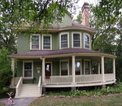 | Charles H. Budd House | 4.0 miles | 1977 |
 | Montevideo Carnegie Library | 4.1 miles | 1982 |
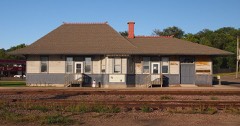 | Chicago, Milwaukee and St. Paul Depot | 4.4 miles | 1988 |
| National Archives record | The nomination case file for reference 85002558 in Record Group 79. |
| Chippewa County | All 8 listed properties in this county. |