 Block
From the record
4 National Register listings published here.
Sources: the National Register database, National Park Service
24 topographic sheets cover 7 settlements here, and 4 properties are on the National Register of Historic Places.
4 National Register listings published here.
Sources: the National Register database, National Park Service
Every property in this county listed on the National Register of Historic Places, with the year it was listed and the federal nomination document.
| Photograph | Property | Type | Listed | Reference |
|---|---|---|---|---|
 | Isaac Bargen House | building | 1986 | 86001285 |
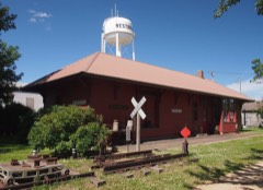 | Chicago, St. Paul, Minneapolis, and Omaha Depot | building | 1986 | 86001286 |
 | Cottonwood County Courthouse | building | 1977 | 77000728 |
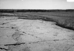 | Jeffers Petroglyphs Site | site | 1970 | 70000291 |
Every wildfire the federal occurrence database records inside this county: 10 of them, burning about 300 acres. None started naturally and 1 was recorded as arson. Each settlement page carries the fires within five miles of it.
| Reported cause | Fires |
|---|---|
| Missing data/not specified/undetermined | 5 |
| Debris and open burning | 3 |
| Equipment and vehicle use | 1 |
| Arson/incendiarism | 1 |
The five largest, by the area the report gives. One of them was set deliberately.
| Date | Cause | Size | Reported by | Name on the report |
|---|---|---|---|---|
| 3 May 2000 | Debris and open burning | 97 acres | Windom Wetland Management District | WOLF LAKE (RX/WF) |
| 11 May 1994 | Debris and open burning | 95 acres | Windom Wetland Management District | LAKE AUGUSTA (RX/WF) |
| 7 May 2020 | Arson/incendiarism | 38 acres | Minnesota Department of Natural Resources | not named |
| 4 October 2012 | Missing data/not specified/undetermined | 33 acres | Windom Wetland Management District | BLIXSETH |
| 31 March 2015 | Missing data/not specified/undetermined | 18 acres | Windom Wetland Management District | LONG LAKE |
| 6 October 2011 | Equipment and vehicle use | 8.0 acres | Windom Wetland Management District | DES MOINES RIVER - THREAT - PL ASSIST |
| 2 April 2015 | Missing data/not specified/undetermined | 3.0 acres | Windom Wetland Management District | GREAT BEND TWP SECT 26 - PL ASSIST |
| 25 March 2003 | Debris and open burning | 3.0 acres | Windom Wetland Management District | MOUNTAIN LAKE |
Every settlement page carries the fires within five miles of it - see the settlement index below.
The NOAA Storm Events Database holds 361 reports for this county, causing no deaths, 7 injuries and about $61,470,250 in recorded property damage. Each settlement page carries the reports that name it.
| Kind of event | Reports |
|---|---|
| Hail | 144 |
| Thunderstorm Wind | 128 |
| Flood | 43 |
| Tornado | 26 |
| Flash Flood | 11 |
| Lightning | 4 |
| Heavy Rain | 3 |
| Wildfire | 1 |
| Funnel Cloud | 1 |
The most serious of them, by death, then injury, then recorded damage. The accounts are quoted exactly as the forecast office filed them.
| When | Event | Place named | Harm | What the report says |
|---|---|---|---|---|
| March 1998 | Tornado (F3) | Westbrook | 3 hurt, $30,000,000 | no account filed |
| June 1976 | Tornado (F2) | not stated | 3 hurt, $250,000 | no account filed |
| June 1985 | Thunderstorm Wind | not stated | 1 hurt | no account filed |
| June 2024 | Flood | Westbrook | $20,700,000 | Rainfall amounts across Cottonwood County from June 20-22 ranged from 6 to 9 inches. Overland flooding ensued with additional major to record flooding along the West Fork Des Moines River.||County-wide, there were significant impacts to personal property with an estimated 1,000 plus homes affected by flood waters. Five homes were declared destroyed and approximately 50 that received major damage. Fifty-two individuals were displaced at peak flooding. A voluntary evacuation order was issued for parts of Windom due to rising waters along the West Fork Des Moines River. Flood waters spared most businesses, but 7 in-home daycares had to close for some amount of time. Damage to private homes and businesses is estimated to be 18 million dollars. ||There was also significant damage to public infrastructure. Numerous county and township roads succumbed to gravel wash. Two bridge abutments required emergency repair. In Windom, State Highway 62 was closed for roughly a week and State Highway 60/U.S. Highway 71 was closed for 3 days. Flood waters also damaged numerous parks and inundated the Windom swimming pool. Preliminary damage assessments estimate loss to public infrastructure to be 2.7 million dollars. ||For additional information on river flooding, please see other flood entries for Cottonwood County. |
| June 1979 | Tornado (F1) | not stated | $2,500,000 | no account filed |
| June 1952 | Tornado (F2) | not stated | $2,500,000 | no account filed |
| July 2018 | Flood | Windom | $2,000,000 | Rainfall of 3 to 5 inches (locally 5 to 10 inches upstream) during the first three days of July exacerbated flooding through the Des Moines River basin. A state of emergency was declared in the City of Windom with water breaching Island Park, the golf course, and several homes. Several county, state and local roadways flooded for up to a week, including highway 62 and numerous city streets. Significant amounts of crop and pasture land near the Des Moines River were severely impacted by major flooding as river levels climbed to the second highest crest on record at 4.4 feet above flood stage at Windom (gage site WDOM5) on July 7. |
| June 2003 | Thunderstorm Wind | Mountain Lake | $1,000,000 | Thunderstorm winds caused widespread tree damage, including numerous trees blown down. Falling trees damaged roofs of houses and destroyed the topper of a pickup truck, and severely damaged another pickup. Power lines were blown down, resulting in power outages. A large storage shed was destroyed. The roof of a house was blown off, and other roof damage to structures was reported. |
| April 2004 | Thunderstorm Wind | Westbrook | $500,000 | Thunderstorm winds blew the roof off a barn and destroyed a machine shed. Two cars, a combine, and a field sprayer in the machine shed were damaged. The winds destroyed a barn on another farm, damaging a tractor and a van inside. The winds blew over a sign anchored in cement, with two tractors being damaged when the sign fell on them. Widespread tree and power line damage was also reported. |
| June 2001 | Thunderstorm Wind | Windom | $500,000 | Thunderstorm winds blew the roof and wall of a large lumber yard building onto a nearby bowling alley. Widespread tree damage included large trees blown down, about a dozen of which fell onto houses and caused further damage. The winds caused roof damage to other structures and blew down power lines. |
| June 2003 | Hail | Mountain Lake | $200,000 | Large hail severely damaged crops, especially corn. Many fields were deemed a total loss. The wind blown hail also damaged vehicles, cracked windows, and damaged the siding of homes. At least one greenhouse was heavily damaged. The hail was blown into drifts several inches high in many places. |
| March 2019 | Flood | Westbrook | $172,000 | Flooding of numerous county and township roads resulted in damage to road beds and culverts. Several towns reported street flooding and water impacting lower and poor drainage areas. The property damage costs include estimates for public property losses. |
| July 1998 | Thunderstorm Wind | Mountain Lake | $150,000 | no account filed |
| August 2005 | Thunderstorm Wind | Westbrook | $100,000 | Thunderstorm winds blew off the roof of an apartment building, and damaged buildings at a lumber yard and at a school bus yard. The winds also caused widespread tree damage, including several trees uprooted. |
| August 2000 | Tornado (F1) | Jeffers | $100,000 | A tornado destroyed a barn and damaged other farm buildings. The tornado also caused crop damage, but the amount of crop damage was not determined. |
| June 1997 | Thunderstorm Wind | Westbrook | $100,000 | no account filed |
| June 2014 | Flood | Westbrook | $50,000 | Persistent moderate to heavy rain caused flooding of fields and other lowlands, including several roads, homes, and businesses. This flooding lasted for two days, and was aggravated locally by additional storms during that time. Some roads were damaged or washed out. |
| September 2010 | Flash Flood | Windom | $50,000 | Heavy rainfall of 5.75 inches caused widespread flash flooding of roads and basements, with sewer backups in Windom. One basement collapsed. |
| April 2004 | Thunderstorm Wind | Westbrook | $50,000 | Thunderstorm winds caused tree damage, including several trees blown down. The winds also blew down power lines. |
| April 2002 | Thunderstorm Wind | Storden | $50,000 | Thunderstorm winds blew the roof off a vehicle repair shop. The roof knocked down power lines when it fell, causing a power outage. |
| August 2000 | Lightning | Storden | $50,000 | Lightning struck a garage, causing a fire which destroyed the garage, a pickup truck, lawn mower, tiller, and a restored bicycle. |
| August 2000 | Thunderstorm Wind | Westbrook | $50,000 | Thunderstorm winds tore the roof off a garage and concession stand at a high school football field, and damaged the scoreboard, bleachers, and the baseball dugout at the school. |
| August 2000 | Thunderstorm Wind | Bingham Lake | $50,000 | Thunderstorm winds caused tree and power line damage, and flattened a corn crop. The amount of crop damage was not known. |
| July 1998 | Thunderstorm Wind | Jeffers | $50,000 | no account filed |
| June 1997 | Thunderstorm Wind | Windom | $50,000 | no account filed |
| May 2004 | Thunderstorm Wind | Westbrook | $30,000 | Thunderstorm winds caused tree damage, including numerous trees blown down. One pine tree penetrated the roof of a house. The house suffered other wind damage, including to the porch. The garage was heavily damaged and farm equipment was damaged. |
| July 1971 | Tornado (F1) | not stated | $25,000 | no account filed |
| August 2021 | Thunderstorm Wind | Westbrook | $20,000 | Thunderstorm winds damaged a grain bin one-half mile south of Westbrook, and an old barn 1 mile south of Westbrook. Property damage costs are a rough estimate. |
| October 2003 | Wildfire | Windom | $20,000 | A wildfire burned 300 acres of grassland and also burned some small sheds. The fire came close to five homesteads, burning to less than 20 yards from two of them. One home had smoke damage from the fire. Dry conditions and winds gusting to 40 mph allowed the fire to advance rapidly before it was brought under control. |
| August 2000 | Hail | Westbrook | $20,000 | Large hail broke windows in two school busses and a few other vehicles. |
| June 1997 | Thunderstorm Wind | Bingham Lake | $20,000 | no account filed |
| June 1997 | Thunderstorm Wind | Westbrook | $20,000 | no account filed |
| June 1997 | Thunderstorm Wind | Storden | $20,000 | no account filed |
| September 2019 | Flood | Westbrook | $10,000 | After excessive two-day rainfall during September 10-12 (5.35 inches at Slayton), the West Fork of the Des Moines River near Avoca (gage site AVOM5) reached the third highest stage on record of 2.71 feet above flood stage on September 16. Significant agricultural land was flooded, with numerous county roads under water. |
| August 2004 | Lightning | Windom | $10,000 | Multiple lightning strikes damaged electrical lines and equipment at an electrical substation, resulting in a city wide power outage. An air conditioner was also damaged. |
| August 2002 | Thunderstorm Wind | Westbrook | $10,000 | Thunderstorm winds caused tree damage, including many branches down. The winds also blew down power lines. |
| July 2000 | Thunderstorm Wind | Storden | $10,000 | Thunderstorm winds caused tree damage, mostly downed branches. The winds also damaged screens and the paint on a house. Crop damage was suspected, but the anount of crop damage could not be determined, partly because hail falling at the same time also caused damage. |
| June 2008 | Tornado (EF0) | Jeffers | $5,000 | A tornado damaged outbuildings and caused tree damage. |
| April 2004 | Thunderstorm Wind | Mountain Lake | $5,000 | Thunderstorm winds destroyed a small shed at an athletic field, and caused tree damage. |
| June 2002 | Lightning | Westbrook | $5,000 | Lightning damaged electronic equipment at a grain elevator, and stripped a large part of the bark from a tree. |
| July 1995 | Thunderstorm Wind | Cottonwood Lake | $5,000 | Thunderstorm winds of unknown speed blew down trees. |
| June 1999 | Thunderstorm Wind | Storden | $5,000 | no account filed |
| July 2004 | Lightning | Westbrook | $3,000 | Lightning struck and destroyed a large tree. The lightning also damaged a computer and a television set in the adjoining house. |
| June 2016 | Thunderstorm Wind | Mountain Lake | $2,000 | Thunderstorm winds damaged several large trees and destroyed an outbuilding. |
| July 1995 | Thunderstorm Wind | Windom | $2,000 | Thunderstorm Winds blew down four to five inch diameter tree limbs. |
| October 1996 | Hail | Mountain Lake | $1,000 | no account filed |
| June 1981 | Tornado (F1) | not stated | $250 | no account filed |
| April 2026 | Hail | Windom | - | Photo provided with ruler for comparison. |
| April 2025 | Hail | Mountain Lake | - | An abundance of dime to nickel size hail fell. |
| September 2025 | Thunderstorm Wind | Windom | - | Several three-inch tree limbs were broken off by thunderstorm wind gusts. |
| September 2025 | Hail | Windom | - | Hail was quarter size or smaller. |
| July 2024 | Flood | Westbrook | - | Flooding continued from June on the Des Moines River near Avoca, with declining river levels. The river fell below flood stage on the morning of July 8th. |
| July 2024 | Flood | Windom | - | Flooding continued from June on the Des Moines River at Windom, with declining river levels. The river fell below flood stage on the evening of July 11th. |
| June 2024 | Flood | Westbrook | - | The West Fork of the Des Moines River near Avoca rose above flood stage the morning of June 21st, cresting around 4.64 feet above flood stage (1429.64 feet) on June 24th. This crest is in the Major Stage. The river stayed above flood stage into July. For a more comprehensive description of flood damage, please see other entries for Cottonwood County. |
| June 2024 | Flood | Windom | - | The West Fork of the Des Moines River at Windom rose above flood stage the morning of June 21st, cresting around 6.01 feet above flood stage (25.01 feet) on June 25th. This crest is in the Major Stage and broke the previous record. The river stayed above flood stage into July. For a more comprehensive description of flood damage, please see other entries for Cottonwood County. |
| April 2023 | Flood | Westbrook | - | The West Fork of the Des Moines River near Avoca, MN rose above flood stage on the afternoon of April 12th before cresting around 0.67 feet above flood stage (1425.67 feet) on April 15th. The river then fell below flood stage on the morning of April 17th. |
| May 2023 | Tornado (EF0) | Windom | - | A landspout quickly spun up around 2 miles northwest of Windom in an open field just north of the Windom Country Club. The weak tornado moved just east of north and crossed 405th Street, where it glanced a farmstead and caused damage to shingles on an outbuilding. The tornado continued about a half mile across open fields before turning more northerly, and crossed 395th Street before lifting less than a quarter mile farther to the north. The maximum wind speed was 65 mph and the average path width was 20 yards. |
| June 2023 | Thunderstorm Wind | Windom Muni Arpt | - | Thunderstorm winds downed up to 10 large trees in a grove. A gazebo was blown at least 200 feet through a garage door and the winds displaced deck furniture up to 500 feet. |
| June 2023 | Tornado (EFU) | Mountain Lake | - | A brief landspout touched down in an open field just east of 560th Avenue and north of Minnesota State Highway 30. This tornado resulted in no visible damage and had no basis for rating. |
| August 2023 | Hail | Storden | - | Pea to dime size hail fell north of Storden. Crop damage is an estimate from insured losses. Information provided by the United States Department of Agriculture. |
The Survey's mineral resources record lists 5 workings inside this county. 3 still produce and 2 are closed or unrecorded. Each settlement page carries the workings within five miles of it.
| Commodity | Workings |
|---|---|
| Sand and Gravel, Construction | 4 |
| Clay | 1 |
The least common of them first, because a county's hundredth gravel pit says nothing its first ten did not.
| Where | Site | Commodity | Status | Recorded |
|---|---|---|---|---|
| Cottonwood County Clay Deposit | Clay | Occurrence | ||
| Christenson Pit | Sand and Gravel, Construction | Past Producer | ||
| L C Pit & Mill | Sand and Gravel, Construction | Producer | ||
| Windom Caldwell Pit | Sand and Gravel, Construction | Producer | ||
| Windom-Windom Pit | Sand and Gravel, Construction | Producer |
Named settlements recorded in the Geographic Names Information System, each with the topographic sheets covering it. Villages, hamlets and abandoned places alike. Each is shown with the nearest named watercourse or landform and the survey quadrangle it falls on.