 Block
From the record
10 National Register listings published here.
Sources: the National Register database, National Park Service
85 topographic sheets cover 42 settlements here, and 10 properties are on the National Register of Historic Places.
10 National Register listings published here.
Sources: the National Register database, National Park Service
Every property in this county listed on the National Register of Historic Places, with the year it was listed and the federal nomination document.
| Photograph | Property | Type | Listed | Reference |
|---|---|---|---|---|
 | Alexander Baker School and E.W. Backus Junior High School | building | 2004 | 04000538 |
 | Finstad's Auto Marine Shop | building | 1983 | 83000906 |
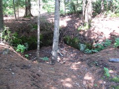 | Gold Mine Sites | district | 1977 | 77000155 |
 | Koochiching County Courthouse | building | 1977 | 77000749 |
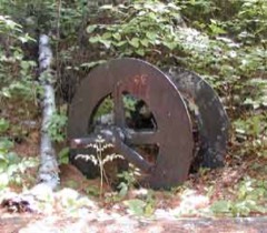 | Little American Mine | site | 1975 | 75000226 |
| Ernest C. Oberholtzer Rainy Lake Islands Historic District | district | 2000 | 00000570 | |
| Ranier Community Building | building | 2018 | 100002502 | |
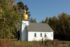 | Sts. Peter and Paul Russian Orthodox Church | building | 1983 | 83000908 |
| Francis White Homestead | building | 1983 | 83000909 | |
| Williams Township School | building | 2018 | 100002503 |
Every wildfire the federal occurrence database records inside this county: 626 of them, burning about 2,774 acres. 36 started naturally and 101 were recorded as arson. Each settlement page carries the fires within five miles of it.
| Reported cause | Fires |
|---|---|
| Debris and open burning | 277 |
| Arson/incendiarism | 101 |
| Missing data/not specified/undetermined | 72 |
| Equipment and vehicle use | 69 |
| Natural | 36 |
| Recreation and ceremony | 35 |
| Smoking | 14 |
| Railroad operations and maintenance | 11 |
| Misuse of fire by a minor | 6 |
| Other causes | 4 |
| Power generation/transmission/distribution | 1 |
The five largest, by the area the report gives. Four of them were set deliberately.
| Date | Cause | Size | Reported by | Name on the report |
|---|---|---|---|---|
| 23 April 1998 | Arson/incendiarism | 201 acres | Minnesota Department of Natural Resources | not named |
| 8 October 2003 | Debris and open burning | 180 acres | Minnesota Department of Natural Resources | not named |
| 3 September 2006 | Debris and open burning | 152 acres | Minnesota Department of Natural Resources | CLEMENTSON FIRE |
| 7 May 1992 | Arson/incendiarism | 106 acres | Minnesota Department of Natural Resources | not named |
| 5 May 1992 | Arson/incendiarism | 97 acres | Minnesota Department of Natural Resources | not named |
| 8 April 2003 | Debris and open burning | 75 acres | Minnesota Department of Natural Resources | not named |
| 2 May 2015 | Arson/incendiarism | 70 acres | Minnesota Department of Natural Resources | not named |
| 23 April 2009 | Debris and open burning | 68 acres | Minnesota Department of Natural Resources | not named |
Every settlement page carries the fires within five miles of it - see the settlement index below.
The NOAA Storm Events Database holds 269 reports for this county, causing 2 deaths, 5 injuries and about $5,762,030 in recorded property damage. Each settlement page carries the reports that name it.
| Kind of event | Reports |
|---|---|
| Hail | 147 |
| Thunderstorm Wind | 104 |
| Tornado | 6 |
| Lightning | 5 |
| Flood | 5 |
| Flash Flood | 2 |
The most serious of them, by death, then injury, then recorded damage. The accounts are quoted exactly as the forecast office filed them.
| When | Event | Place named | Harm | What the report says |
|---|---|---|---|---|
| August 1993 | Tornado (F0) | to 4 E | 2 killed, $50,000 | A tornado touched down to the southwest of a trailer home near the town of Littlefork. The tornado lifted the mobile home and deposited it about 0.25 mile to the northeast. Two people were killed and the mobile home was destroyed. Damage was estimated at $20,000. (M51M, F46M) |
| September 1973 | Tornado (F2) | not stated | 5 hurt, $250,000 | no account filed |
| May 1998 | Hail | International Falls | $3,000,000 | no account filed |
| July 2022 | Flood | International Falls | $2,400,000 | Above normal snowfall for the 2021-2022 season was observed across northern portions of Koochiching and St. Louis counties and much of that remained on the ground into April. Heavy rainfall then fell on top of that above normal snowpack at the end of April and sent abnormally high amounts of runoff into the Rainy River Basin leading to rises on Rainy Lake. International Falls experienced their wettest April on record, helping to set the stage for the flooding. By June 15th, the level of Rainy Lake reached 1113.2 feet which was 22 inches above the 2014 peak level and 2.5 inches above the all-time record set in 1950. Having crested and setting a new all-time high, the lake level fell over the remainder of the month to 1112.4 feet (13 inches above 2014 peak and slightly below the 1950 record) by the start of July. The high lake levels led to extensive damage to properties adjacent to the water along with damage to docks and other infrastructure. Lake levels would continue to fall into July and the Flood Warning was canceled on July 11th. Levels on Rainy Lake remained above normal at this time, but were receding and the threat for additional flooding had ended. State and Federal disasters were declared for the event with millions of dollars in infrastructure damage and property loss. |
| July 2014 | Flood | South Intl Falls | $28,000 | FEMA calculated that the county was eligible for $28,000 in assistance for debris cleanup and to repair public docks, roads, ditches, shoulders and bridges. |
| August 1998 | Lightning | International Falls | $25,000 | no account filed |
| July 2008 | Thunderstorm Wind | Ray | $5,000 | A roof was damaged along Highway 217 near mile post 17. |
| July 2014 | Thunderstorm Wind | (Inl)Intl Falls Arpt | $2,000 | More than 200 trees were blown down at a country club. Parts of the roof from the outdoor deck by the clubhouse ended up on the number 18 tee. |
| July 2014 | Thunderstorm Wind | International Falls | $1,000 | A carport and woodshed were blown down and destroyed. |
| September 2005 | Lightning | Little Fork | $1,000 | Lightning struck the television antenna on top of a home on County Road 29 and follwed a cable line down into the ceiling of the basement where it began to smolder. Damage was isolated to the basement. |
| July 1981 | Tornado (F0) | not stated | $30 | no account filed |
| July 2025 | Thunderstorm Wind | (Inl)Intl Falls Arpt | - | A gust of 78 mph was recorded by the KINL International Falls Airport ASOS station. |
| August 2023 | Hail | Ray | - | Hail was mostly dime-sized but a few hailstones were quarter-sized. |
| May 2022 | Thunderstorm Wind | International Falls | - | A large pine tree was down in International Falls. |
| May 2022 | Thunderstorm Wind | Little Fork | - | Trees were reported down near US Highway 71 and State Highway 65. |
| May 2022 | Flood | International Falls | - | Above normal snowfall for the 2021-2022 season was observed across northern portions of Koochiching and St. Louis counties and much of that remained on the ground into April. Heavy rainfall then fell on top of that above normal snowpack at the end of April and sent abnormally high amounts of runoff into the Rainy River Basin leading to rises on Namakan Lake and Kabetogama Lake. International Falls experienced their wettest April on record, helping to set the stage for the flooding. By the end of May, the level of Rainy Lake reached 1112.4 feet which was 12 inches above the 2014 peak level and 7 inches below the all-time record set in 1950. The high lake levels led to extensive damage to properties adjacent to the water along with damage to docks and other infrastructure. Lake levels would continue to rise into June. |
| July 2022 | Thunderstorm Wind | International Falls | - | Numerous trees and powerlines were downed by the winds. |
| July 2022 | Thunderstorm Wind | (Inl)Intl Falls Arpt | - | Three birch trees snapped in half during the storm. |
| June 2022 | Thunderstorm Wind | Indus | - | An eighteen inch diameter poplar tree was blown over and blocking a road. There were also several other poplar trees with tops blown off that measured six to eight inches in diameter. |
| June 2022 | Flood | International Falls | - | Above normal snowfall for the 2021-2022 season was observed across northern portions of Koochiching and St. Louis counties and much of that remained on the ground into April. Heavy rainfall then fell on top of that above normal snowpack at the end of April and sent abnormally high amounts of runoff into the Rainy River Basin leading to rises on Rainy Lake. International Falls experienced their wettest April on record, helping to set the stage for the flooding. By June 15th, the level of Rainy Lake reached 1113.2 feet which was 22 inches above the 2014 peak level and 2.5 inches above the all-time record set in 1950. Having crested and setting a new all-time high, the lake level fell over the remainder of the month to 1112.4 feet (13 inches above 2014 peak and slightly below the 1950 record) by the start of July. The high lake levels led to extensive damage to properties adjacent to the water along with damage to docks and other infrastructure. Lake levels would continue to fall into July. |
| July 2021 | Thunderstorm Wind | (Inl)Intl Falls Arpt | - | A tree was reported down on a power line along County Road 2 near the International Falls Airport. |
| July 2019 | Thunderstorm Wind | Rainy Lake | - | A photo was received via social media of a large tree down on a power line near the Island View Lodge. |
| July 2019 | Thunderstorm Wind | Silverdale | - | Five pine and aspen trees about 2 feet in diameter were knocked down due to straight line winds. |
| July 2019 | Thunderstorm Wind | Birchdale | - | The gust was recorded by the MnDOT Road Weather Station MN026 at Birchdale MN-11 Mile Post 157. |
| July 2019 | Thunderstorm Wind | Little Fork | - | Trees were down along Highway 65 near Littlefork with some of the trees taking down power lines as well. |
| July 2019 | Thunderstorm Wind | Little Fork | - | Bleachers were damaged at the fairgrounds and a tree was down on a power line in Littlefork. |
| July 2018 | Thunderstorm Wind | Big Falls | - | A few trees were blown down along State Highway 6. |
| July 2018 | Thunderstorm Wind | Grand Falls | - | Strong winds toppled a flagpole, took the tops off of a few large trees and brought down numerous branches. Pea size hail was also observed. |
| July 2018 | Thunderstorm Wind | Ridge | - | Multiple trees were downed by the thunderstorm winds. |
| July 2018 | Thunderstorm Wind | Craigville | - | Multiple trees were blown down. |
| July 2018 | Thunderstorm Wind | Big Falls | - | Two trees were blown down across the road. |
| July 2018 | Thunderstorm Wind | Grand Falls | - | A few trees were blown down onto power lines. |
| August 2018 | Thunderstorm Wind | (Inl)Intl Falls Arpt | - | Numerous large trees were uprooted and snapped in International Falls leading to multiple power outages. |
| June 2016 | Hail | Nakoda | - | Most of the hail stones were 1.75 inches in diameter, but there were several up 2 inches in diameter. |
| June 2016 | Hail | Island View | - | The report was from a Voyageurs National Park Ranger. |
| June 2016 | Thunderstorm Wind | International Falls | - | There were trees down across town. Crews were dispatched to clear trees after 6 am. |
| July 2016 | Thunderstorm Wind | Grand Falls | - | There were a few trees blown down on County Road 31 and Highway 6 in Big Falls. |
| July 2014 | Thunderstorm Wind | Little Fork | - | Several trees were blown down. |
| July 2014 | Thunderstorm Wind | Pelland | - | A roof of a house was blown off near Pelland Junction. |
| July 2014 | Thunderstorm Wind | Birchdale | - | Trees were blown down across County Road 86. |
| June 2014 | Flood | Clementson | - | Very high to historic water levels on Rainy Lake and the Rainy River during the middle and late part of June threatened, damaged, and destroyed property along the shoreline. Some roads were closed to the river flooding, including stretches of Highway 11 in northern Koochiching County. |
| July 2014 | Thunderstorm Wind | Laurel | - | The winds knocked out the power. |
| July 2014 | Thunderstorm Wind | Silverdale | - | Trees were blown down. |
| July 2014 | Thunderstorm Wind | Little Fork | - | The winds knocked out the power. |
| July 2014 | Thunderstorm Wind | Silverdale | - | Trees were blown down. |
| July 2013 | Hail | International Falls | - | A thunderstorm dropped mostly pea sized hail, but there were a few nickel and dime sized hailstones. |
| July 2011 | Thunderstorm Wind | South Intl Falls | - | Power lines were blown down near the intersection of Route 53 and County Road 332. |
| July 2011 | Thunderstorm Wind | Ericsburg | - | Some tree limbs were blown down and one tree was blown down over Highway 217. |
| July 2011 | Thunderstorm Wind | Mizpah | - | Tree branches were blown down. |
| July 2010 | Flash Flood | International Falls | - | Water was covering U.S. Highway 53 just south of International Falls. |
| May 2010 | Thunderstorm Wind | Pinetop | - | A roof was blown off a pole barn. |
| May 2010 | Hail | Big Falls | - | The hail fell for ten minutes. |
| August 2010 | Hail | Little Fork | - | The hail fell for 10 minutes, with U.S. Highway 71 completely covered. Very strong wind gusts accompanied the hail. |
| May 2008 | Thunderstorm Wind | Little Fork | - | Shingles were blown off the roof of a house. |
| July 2008 | Thunderstorm Wind | Little Fork | - | Several large trees were blown down. |
| July 2008 | Hail | Little Fork | - | The hail was completely covering the ground. |
| July 2008 | Thunderstorm Wind | Little Fork | - | An 18-inch spruce tree was snapped and a 30-inch oak tree was blown down. Several other trees were blown down. |
| July 2008 | Thunderstorm Wind | Little Fork | - | Peak wind gust was reported at the Littlefork RAWS Station. |
| July 2008 | Thunderstorm Wind | Little Fork | - | Twelve inch diameter trees were blown down across 2nd Street in Littlefork, along with damage to garages in town. |
| July 2007 | Thunderstorm Wind | International Falls | - | The strong thudnerstorm winds blew down trees and caused damage to private homes. |
The Survey's mineral resources record lists 21 workings inside this county. 15 still produce and 6 are closed or unrecorded. Each settlement page carries the workings within five miles of it.
| Commodity | Workings |
|---|---|
| Sand and Gravel, Construction | 14 |
| Gold | 5 |
| Sulfur-Pyrite | 1 |
| Peat | 1 |
| Stone, Crushed/Broken | 1 |
The least common of them first, because a county's hundredth gravel pit says nothing its first ten did not.
| Where | Site | Commodity | Status | Recorded |
|---|---|---|---|---|
| Koochiching County Peat Bogs | Peat | Occurrence | ||
| Little America Mine | Gold, Sulfur-Pyrite | Past Producer | 1893, 1894 | |
| Ranier Quarry | Stone, Crushed/Broken | Producer | ||
| Bushyhead Island Prospect | Gold | Unknown | Gold | |
| Grassy Island Prospect | Gold | Unknown | Gold | |
| Indus Prospect | Gold | Unknown | Gold, Pyrite, Pyrrhotite | |
| Lyle Mine | Gold | Occurrence | Gold | |
| Boise Cascade Pit | Sand and Gravel, Construction | Producer | ||
| County Pit No 1 | Sand and Gravel, Construction | Producer | ||
| County Pit No 2 | Sand and Gravel, Construction | Producer | ||
| Gemmell Ridge Pit | Sand and Gravel, Construction | Producer | ||
| Happyland Pit | Sand and Gravel, Construction | Producer | ||
| Happyland Pit No 2 | Sand and Gravel, Construction | Producer | ||
| Happyland Pit and Mill | Sand and Gravel, Construction | Producer | ||
| International Falls Pit | Sand and Gravel, Construction | Producer | ||
| Kolinski Pit and Mill | Sand and Gravel, Construction | Producer | ||
| Little Fork Pit | Sand and Gravel, Construction | Producer | ||
| Oveson Pit | Sand and Gravel, Construction | Producer | ||
| Peterson Pit | Sand and Gravel, Construction | Producer | ||
| Ranier Gravel Pit | Sand and Gravel, Construction | Producer | ||
| Ranier Pit and Mill | Sand and Gravel, Construction | Producer |
Named settlements recorded in the Geographic Names Information System, each with the topographic sheets covering it. Villages, hamlets and abandoned places alike. Each is shown with the nearest named watercourse or landform and the survey quadrangle it falls on.
South Koochiching unorganized territory · 56627 · Lindford SW quadrangle
7 sheets, 1943 to 1978
South Koochiching unorganized territory · 56627 · Big Falls quadrangle
7 sheets, 1919 to 1978
Northwest Koochiching unorganized territory · 56629 · Birchdale quadrangle
7 sheets, 1919 to 1976
Northwest Koochiching unorganized territory · 56623 · Border quadrangle
6 sheets, 1954 to 1976
Northwest Koochiching unorganized territory · 56623 · Border quadrangle
6 sheets, 1954 to 1976
South Koochiching unorganized territory · 56639 · Craigville quadrangle
8 sheets, 1954 to 1976
Northwest Koochiching unorganized territory · 56629 · Fairland quadrangle
7 sheets, 1919 to 1977
Northwest Koochiching unorganized territory · 56629 · On Whitefish Creek · Border quadrangle
6 sheets, 1954 to 1976
Northwest Koochiching unorganized territory · 56627 · Ridge NE quadrangle
8 sheets, 1919 to 1977
South Koochiching unorganized territory · 56627 · Big Falls quadrangle
7 sheets, 1919 to 1978
Northwest Koochiching unorganized territory · 56627 · Lindford SE quadrangle
7 sheets, 1943 to 1978
Northwest Koochiching unorganized territory · 56629 · Near Smoot Island · Loman OE N quadrangle
5 sheets, 1954 to 1978
Rainy Lake unorganized territory · 56649 · International Falls quadrangle
9 sheets, 1919 to 1999
Rainy Lake unorganized territory · 56649 · Near Dove Island · Island View quadrangle
10 sheets, 1954 to 1999
Northwest Koochiching unorganized territory · 56654 · On West Fork Black River · Loman quadrangle
6 sheets, 1954 to 1978
Northwest Koochiching unorganized territory · 56629 · Manitou OE N quadrangle
5 sheets, 1954 to 1978
Rainy Lake unorganized territory · 56649 · International Falls quadrangle
9 sheets, 1919 to 1999
Rainy Lake unorganized territory · 56649 · On Little Fork River · Pelland quadrangle
8 sheets, 1919 to 1978
South Koochiching unorganized territory · 55771 · On Willow River · Rauch quadrangle
8 sheets, 1954 to 1976
Rainy Lake unorganized territory · 56649 · Near Dove Island · Island View quadrangle
10 sheets, 1954 to 1999
South Koochiching unorganized territory · 55771 · On Bois Forte Creek · Silverdale quadrangle
8 sheets, 1954 to 1976
Rainy Lake unorganized territory · 56649 · International Falls quadrangle
9 sheets, 1919 to 1999
Rainy Lake unorganized territory · 56649 · Near Aeroplane Island · Island View quadrangle
10 sheets, 1954 to 1999
South Koochiching unorganized territory · 56627 · On Sturgeon River · Big Falls NW quadrangle
7 sheets, 1919 to 1978
Rainy Lake unorganized territory · 56649 · Near Little American Island · Island View quadrangle
10 sheets, 1954 to 1999
Northwest Koochiching unorganized territory · 56629 · Wayland quadrangle
6 sheets, 1954 to 1977
South Koochiching unorganized territory · 56627 · Littlefork SW quadrangle
7 sheets, 1919 to 1978