 Block
From the record
8 National Register listings published here.
Sources: the National Register database, National Park Service
15 topographic sheets cover 7 settlements here, and 8 properties are on the National Register of Historic Places.
8 National Register listings published here.
Sources: the National Register database, National Park Service
Every property in this county listed on the National Register of Historic Places, with the year it was listed and the federal nomination document.
| Photograph | Property | Type | Listed | Reference |
|---|---|---|---|---|
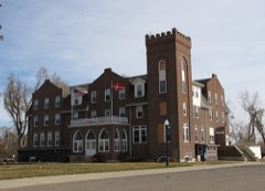 | Danebod | district | 1975 | 75000993 |
| Drammen Farmers' Club | building | 1980 | 80004539 | |
| Lake Benton Opera House | building | 1977 | 77000753 | |
| Lake Benton Opera House and Kimball Building (Boundary Increase) | building | 1982 | 82002979 | |
| Lincoln County Courthouse and Jail | building | 1980 | 80004541 | |
| Lincoln County Fairgrounds | building | 1980 | 80002088 | |
| Ernst Osbeck House | building | 1980 | 80004540 | |
| Tyler Public School | building | 1980 | 80002089 |
Every wildfire the federal occurrence database records inside this county: 2 of them, burning about 2 acres. None started naturally and none was recorded as arson. Each settlement page carries the fires within five miles of it.
| Reported cause | Fires |
|---|---|
| Missing data/not specified/undetermined | 2 |
The five largest, by the area the report gives. None of them was recorded as arson.
| Date | Cause | Size | Reported by | Name on the report |
|---|---|---|---|---|
| 18 November 2011 | Missing data/not specified/undetermined | 1.6 acres | Big Stone National Wildlife Refuge | KRAGH |
| 11 October 2012 | Missing data/not specified/undetermined | under an acre | Minnesota Department of Natural Resources | not named |
Every settlement page carries the fires within five miles of it - see the settlement index below.
The NOAA Storm Events Database holds 254 reports for this county, causing no deaths, 1 injury and about $3,719,000 in recorded property damage. Each settlement page carries the reports that name it.
| Kind of event | Reports |
|---|---|
| Hail | 112 |
| Thunderstorm Wind | 90 |
| Flood | 26 |
| Tornado | 18 |
| Flash Flood | 5 |
| Heavy Rain | 2 |
| Funnel Cloud | 1 |
The most serious of them, by death, then injury, then recorded damage. The accounts are quoted exactly as the forecast office filed them.
| When | Event | Place named | Harm | What the report says |
|---|---|---|---|---|
| July 1955 | Tornado (F1) | not stated | 1 hurt | no account filed |
| July 1995 | Thunderstorm Wind | Tracy | $1,000,000 | Thunderstorm winds of unknown speed blew down a radio tower and power lines, caused widespread tree damage, blew the roof off of a home and caused other building damage. The winds combined with heavy rain to flatten corn and soybean crops. The damage occurred over a roughly 10 by 20 mile area. Crop damage was undetermined because some crops were expected to recover and the extent of recovery would not be known until after harvest. However, the damage was known to be major, and the Farm Service Agency director estimated that 99,000 acres in the county were at least somewhat affected by the winds and accompanying hail and heavy rain. |
| May 1993 | Thunderstorm Wind | Tyler | $500,000 | Thunderstorm winds blew down power lines and damaged many homes causing an estimated $200,000 dollars damage. |
| June 1970 | Tornado (F1) | not stated | $250,000 | no account filed |
| April 1955 | Tornado (F2) | not stated | $250,000 | no account filed |
| April 2011 | Flood | Hendricks | $200,000 | Flooding of lakes, streams, and lowlands, including some farmland, continued in the county through April. While flooding of small streams abated, lake and lowland flooding continued with very slow improvement. Several roads remained flooded. High water and groundwater levels resulting from record precipitation in the previous year was the main reason that the flooding either grew worse or improved so slowly. |
| October 1996 | Thunderstorm Wind | Lake Benton | $200,000 | no account filed |
| April 2019 | Flood | Arco | $152,000 | Runoff from occasional precipitation in late March and very early April maintained significant flooding of agricultural and pasture lands near the Redwood River. The Redwood River at Russell (gage site RUSM5) crested at 0.80 feet above flood stage on April 8. |
| March 2019 | Flood | Verdi | $118,000 | Flooding resulted in damage to public infrastructure including county and township roads and culverts. The property damage costs include estimates for public property losses. |
| July 2011 | Tornado (EF2) | Tyler | $100,000 | A tornado destroyed several outbuildings and storage buildings, took the roofs off several other structures, and otherwise damaged the siding and roofs of several structures including some homes. Widespread tree damage included several trees blown down and debarking at tree tops. |
| June 2004 | Tornado (F1) | Wilno | $100,000 | A tornado destroyed a barn, machine shed, and several outbuildings on two farms. The tornado blew the roof off a hoop barn and caused a tarp covering the barn to fall on hogs inside, suffocating several of them. Two sprayers, three tractors, and other equipment in the machine shed were damaged. The tornado also damaged trees and crops. |
| July 2002 | Hail | Lake Benton | $100,000 | Large hail caused damage to windows, vehicles, and crops. The amount of crop damage was not known. |
| June 2001 | Thunderstorm Wind | Hendricks | $100,000 | Thunderstorm winds caused widespread tree damage, including trees four feet in diameter blown down. A barn was blown down, and the roof of another building was blown off. Power lines and poles were blown down. |
| June 1997 | Hail | Lake Benton | $100,000 | Large hail devastated crops in most of Lincoln County. An estimated 180 thousand acres of crops were affected, with 80 thousand acres totally destroyed. |
| June 1997 | Thunderstorm Wind | Lake Benton | $100,000 | Thunderstorm winds caused tree damage and other minor property damage in much of Lincoln County. |
| April 2004 | Hail | Lake Benton | $100,000 | no account filed |
| August 1996 | Thunderstorm Wind | Lake Benton | $100,000 | no account filed |
| June 2001 | Tornado (F1) | Verdi | $50,000 | A tornado was observed with a dust and debris cloud. The tornado destroyed several outbuildings and a cattle shed, severely damaged a hog barn and granary, and tipped two wagons over. |
| July 1970 | Tornado (F1) | not stated | $25,000 | no account filed |
| June 1967 | Tornado (F0) | not stated | $25,000 | no account filed |
| June 1956 | Tornado (F1) | not stated | $25,000 | no account filed |
| May 2000 | Thunderstorm Wind | Hendricks | $20,000 | Thunderstorms winds blew over a semi tractor trailer. |
| July 1999 | Thunderstorm Wind | Lake Benton | $20,000 | no account filed |
| October 1997 | Thunderstorm Wind | Ivanhoe | $15,000 | no account filed |
| September 2019 | Flood | Arco | $10,000 | After excessive two-day rainfall during September 10-12 (5.70 inches at Marshall), the Redwood River at Russell (gage site RUSM5) reached the sixth highest stage on record of 1.81 feet above flood stage on September 12. Significant agricultural land was flooded, with numerous county roads under water. |
| July 2011 | Thunderstorm Wind | Verch | $10,000 | Thunderstorm winds damaged a silo and a barn. The winds also caused tree damage, including several trees snapped off. |
| July 2011 | Thunderstorm Wind | Lake Benton | $10,000 | Thunderstorm winds blew down numerous power lines along U.S. Highway 14, and caused tree damage. |
| June 2010 | Thunderstorm Wind | Hendricks | $10,000 | Thunderstorm winds blew the roofs off several grain bins. The winds were accompanied by small hail. |
| September 2019 | Flood | Lake Benton | $5,000 | After excessive two-day rainfall during September 10-12 (8.93 inches at Flandreau and 8.64 inches near Pipestone), Flandreau Creek near Flandreau (gage site FCRS2) reached the highest stage on record of 5.46 feet above flood stage on September 12. Numerous township and county roads were inundated by water, as well as significant amounts of agricultural land. |
| July 2011 | Thunderstorm Wind | Verch | $5,000 | Thunderstorm winds blew down weather observation equipment and caused tree damage, including up to 8 inch diameter branches blown down. |
| May 1996 | Thunderstorm Wind | Tyler | $5,000 | no account filed |
| June 1966 | Tornado (F0) | not stated | $2,500 | no account filed |
| August 2021 | Thunderstorm Wind | Ivanhoe | $2,000 | Thunderstorm wind gusts knocked down several 8 inch diameter tree limbs. Property damage costs are a rough estimate. |
| August 2021 | Thunderstorm Wind | Ivanhoe | $2,000 | Thunderstorm wind gusts downed a few trees in Ivanhoe. Property damage costs are a rough estimate. |
| June 2020 | Thunderstorm Wind | Hendricks | $2,000 | A large barn door was blown in and bent. Property damage costs are rough estimates. |
| August 2015 | Thunderstorm Wind | Ivanhoe | $2,000 | Thunderstorm winds damaged two silos, and blew doors off a pole barn. |
| June 2001 | Tornado (F1) | Lake Benton | $2,000 | A tornado which formed just west of the state line crossed into Minnesota and immediately destroyed two outbuildings on a farm near highway 14. Debris from the outbuildings was stretched over one and a half miles. |
| June 2020 | Thunderstorm Wind | Arco | $1,000 | A flag pole was snapped off by strong winds. Lawn furniture was blown all over the yard, with power also knocked out. Wind-driven hail up to one-half inch in diameter shredded crops. Property damage costs are rough estimates. Crop damage is an estimate from insured losses. Information provided by the United States Department of Agriculture. |
| June 2020 | Thunderstorm Wind | Hendricks | $500 | Damage occurred to small to moderate tree limbs. Property damage costs are rough estimates. |
| August 2025 | Thunderstorm Wind | Verch | - | Thunderstorm winds downed a tree along U.S. Highway 14 near the South Dakota/Minnesota border. |
| June 2025 | Thunderstorm Wind | Hendricks | - | Thunderstorm winds downed a few trees in Hendricks. |
| May 2024 | Thunderstorm Wind | Ivanhoe | - | Winds downed several trees around Ivanhoe as well as a power line. |
| May 2024 | Thunderstorm Wind | Verch | - | Multiple large tree branches were downed by thunderstorm winds. |
| May 2024 | Thunderstorm Wind | Verch | - | Thunderstorm winds downed several trees and branches throughout Verdi. |
| July 2024 | Thunderstorm Wind | Lake Benton | - | Thunderstorm wind gusts were measured at the Minnesota Road Weather Information System site near Lake Benton, with a peak gust of 64 mph at 1928 CST. |
| June 2024 | Flood | Arco | - | The Redwood River at Russell rose above flood stage the evening of June 21st, cresting around 2.73 feet above flood stage (16.73 feet) on June 23rd. The river then fell below flood stage on the evening of June 27th. For a more comprehensive description of flood damage, please see other entries for Lincoln County. |
| June 2024 | Flash Flood | Verdi | - | Rainfall of 2 to 3 inches in a couple hours on saturated soil resulted in flash flooding. Several roads were inundated near Lake Benton and Verdi. For a more comprehensive description of flood damage, please see other entries for river flooding for Lincoln County. |
| June 2024 | Flood | Lake Benton | - | Flandreau Creek near Flandreau rose above flood stage the morning of June 22nd, cresting around 2.46 feet above flood stage (11.46 feet) on June 22nd. This crest is in the Moderate Stage. The creek then fell below flood stage on the afternoon of June 24th. For a more comprehensive description of flood damage, please see other entries for Lincoln County. |
| June 2024 | Thunderstorm Wind | Hendricks | - | Thunderstorm wind gusts downed several trees and powerlines near the intersection of County Roads 15 and 1. Damage extended further east with minor property damage near the intersection of County Road 15 and 103. Crop damage is an estimate from insured losses. Information provided by the United States Department of Agriculture. |
| July 2023 | Hail | Hendricks | - | Hail varied in size from pea to golf ball. |
| April 2023 | Flood | Lake Benton | - | Flandreau Creek near Flandeau, SD rose above flood stage on the early morning of April 9th before cresting around 0.28 feet above flood stage (9.28 feet) on April 9th. The creek then quickly fell below flood stage midday on April 9th. |
| April 2023 | Flood | Arco | - | The Redwood River near Russell, MN rose above flood stage during the early morning of April 12th before cresting around 0.63 feet above flood stage (14.63 feet) on April 13th. The river then fell below flood stage on the evening of April 13th. |
| July 2023 | Hail | Ivanhoe | - | Hail varied from dime to quarter size. |
| July 2023 | Hail | Lake Benton | - | Crop damage is an estimate from insured losses. Information provided by the United States Department of Agriculture. |
| May 2022 | Hail | Hendricks | - | Crop damage is an estimate from insured losses. Information provided by the United States Department of Agriculture. |
| May 2022 | Thunderstorm Wind | Arco | - | A thunderstorm wind gust of 70 mph was measured at mesonet site AT653, 3 miles west of Arco. |
| May 2022 | Thunderstorm Wind | Hendricks | - | A thunderstorm wind gust of 68 mph was measured by Minnesota Road Weather Information System site MN029 5 miles south of Hendricks. |
| May 2022 | Thunderstorm Wind | Lake Benton | - | A thunderstorm wind gust of 68 mph was measured by Minnesota Road Weather Information System site MN027 1 mile west-northwest of Lake Benton. |
| May 2022 | Thunderstorm Wind | Lake Benton | - | A thunderstorm wind gust of 62 mph was measured by Minnesota Road Weather Information System site MN027 1 mile west-northwest of Lake Benton. |
| May 2022 | Thunderstorm Wind | Lake Benton | - | Large sections of the roof on a single-family home were blown off by thunderstorm winds. |
The Survey's mineral resources record lists 2 workings inside this county. All of them still produce. Each settlement page carries the workings within five miles of it.
| Commodity | Workings |
|---|---|
| Sand and Gravel, Construction | 2 |
The least common of them first, because a county's hundredth gravel pit says nothing its first ten did not.
| Where | Site | Commodity | Status | Recorded |
|---|---|---|---|---|
| Jasperson Pit | Sand and Gravel, Construction | Producer | ||
| Lake Benton Pit | Sand and Gravel, Construction | Producer |
Named settlements recorded in the Geographic Names Information System, each with the topographic sheets covering it. Villages, hamlets and abandoned places alike. Each is shown with the nearest named watercourse or landform and the survey quadrangle it falls on.