
BlockBefore
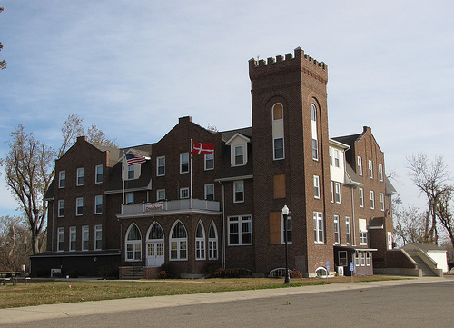
Photograph of Danebod
Photograph by Jatakuck, CC BY-SA 3.0. Via Wikimedia Commons.

Danebod

Listed on the National Register of Historic Places in 1975.

From the record

“Danebod is a historic district at the south edge of the railway town of Tyler in southwestern Minnesota. Founded in 1885 by Danish Evangelical Lutherans led by Rev.”

Wikipedia article Danebod, CC BY-SA 4.0.

One of 8 National Register listings published here for Lincoln County · listed in 1975 · category: District.

Sources: the Wikipedia article · the case file at the National Archives · the National Register database, National Park Service

The listing

  • What is counted as historic. The nomination lists 4 buildingss as contributing to the listing.
  • Address. Danebod Ct., Tyler, 56178
  • When was it listed? June 1975
  • Category. district
  • City. Tyler city
  • National Register reference number. 75000993 - the number the National Park Service assigned this property when it was listed, and the key its nomination file is catalogued under at the National Archives.

Storms near this property

19 since 1993

Regional context, not property-specific evidence. The National Weather Service names Tyler, the town this property stands in, in 19 storm reports between 1993 and 2022: 13 hail, 3 tornado, 2 thunderstorm wind, 1 heavy rain. No death or injury is recorded in these reports. Each account below is quoted exactly as the forecast office filed it, from the NOAA Storm Events Database, and each date opens the federal record of that event.

WhenEvent Place namedHarm What the report says
May 1993Thunderstorm WindTyler$500,000Thunderstorm winds blew down power lines and damaged many homes causing an estimated $200,000 dollars damage.
July 2011Tornado (EF2)Tyler$100,000A tornado destroyed several outbuildings and storage buildings, took the roofs off several other structures, and otherwise damaged the siding and roofs of several structures including some homes. Widespread tree damage included several trees blown down and debarking at tree tops.
May 1996Thunderstorm WindTyler$5,000no account filed
August 2014Heavy RainTyler-Rainfall of 2.50 inches was accompanied by nickel size hail.
August 2014HailTyler-Hail was accompanied by heavy rain.
June 2013HailTyler-Large hail caused an unknown amount of damage to vehicles and windows.
April 2012HailTyler-Large hail whitened the ground.
July 2002HailTyler-Large hail caused damage to vehicles, windows, and crops. The amount of damage was not known.
June 2001Tornado (F0)Tyler-A brief tornado caused no reported damage or injuries.
July 1995HailTyler-Hail of unknown size fell for 45 minutes and flattened crops north of Tyler near the east end of Lake Benton. Damage was undetermined due to unknown recovery of crops and because of concurrent damage due to strong thunderstorm Winds.
May 2022HailTyler-no account filed
June 2006HailTyler-no account filed
August 2004HailTyler-no account filed
May 2002HailTyler-no account filed
August 2002HailTyler-no account filed
June 2001HailTyler-no account filed
June 1999HailTyler-no account filed

Every storm recorded in Lincoln County

Map coverage status

No historic map-sheet match is published for this property yet. That does not mean no map exists. This record needs a coordinate-quality review before it can be joined to a sheet boundary. Browse the county's mapped places while that work is pending.

Listed places nearby

5 within 8 miles

Other National Register properties close enough to walk or drive between, ordered by distance from this one. Both positions come from the same geocoding pass that matched these properties to their map sheets.

Photograph PropertyDistance Listed
Tyler Public School0.9 miles1980
Lincoln County Fairgrounds1.0 miles1980
Lake Benton Opera House and Kimball Building (Boundary Increase)7.6 miles1982
Lake Benton Opera House7.6 miles1977
Ernst Osbeck House7.6 miles1980

Sources for this property

National Archives recordThe nomination case file for reference 75000993 in Record Group 79.
Wikipedia articleCommunity-written account of this property, licensed CC BY-SA.
Lincoln CountyAll 8 listed properties in this county.

Provenance

  • Listing record. National Park Service National Register of Historic Places, listed-properties dataset, current to 2026-05-22.
  • Map join. Address geocoded through the United States Census geocoder, then tested against the published boundary of every sheet in the USGS Historical Topographic Map Collection.
  • How this page is made. Listing fields come from federal records; map-sheet coverage is a labelled coordinate-to-boundary calculation, not a source-field claim.
  • Storms. NOAA National Centers for Environmental Information, Storm Events Database https://www.ncei.noaa.gov/stormevents/ A work of the United States government, no copyright under 17 U.S.C. 105. Narratives are quoted verbatim from the National Weather Service report and are not edited or summarised.