 Block
From the record
3 National Register listings published here.
Sources: the National Register database, National Park Service
54 topographic sheets cover 23 settlements here, and 3 properties are on the National Register of Historic Places.
3 National Register listings published here.
Sources: the National Register database, National Park Service
Every property in this county listed on the National Register of Historic Places, with the year it was listed and the federal nomination document.
| Photograph | Property | Type | Listed | Reference |
|---|---|---|---|---|
| Larson Mill | building | 1973 | 73000983 | |
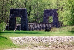 | Old Mill State Park WPA/Rustic Style Historic Resources | district | 1989 | 89001667 |
 | K.J. Taralseth Company | building | 2002 | 02000938 |
Every wildfire the federal occurrence database records inside this county: 649 of them, burning about 65,724 acres. 3 started naturally and 354 were recorded as arson. Each settlement page carries the fires within five miles of it.
| Reported cause | Fires |
|---|---|
| Arson/incendiarism | 354 |
| Debris and open burning | 191 |
| Equipment and vehicle use | 38 |
| Missing data/not specified/undetermined | 35 |
| Railroad operations and maintenance | 14 |
| Recreation and ceremony | 6 |
| Power generation/transmission/distribution | 4 |
| Natural | 3 |
| Smoking | 2 |
| Fireworks | 1 |
| Misuse of fire by a minor | 1 |
The five largest, by the area the report gives. Five of them were set deliberately.
| Date | Cause | Size | Reported by | Name on the report |
|---|---|---|---|---|
| 30 September 2012 | Missing data/not specified/undetermined | 4,440 acres | Minnesota Department of Natural Resources | COUNTY 27 FIRE |
| 3 May 2003 | Missing data/not specified/undetermined | 2,150 acres | Minnesota Department of Natural Resources | AGASSIZ |
| 23 April 1998 | Arson/incendiarism | 1,920 acres | Minnesota Department of Natural Resources | not named |
| 15 April 2007 | Arson/incendiarism | 1,600 acres | Minnesota Department of Natural Resources | LINCOLN |
| 3 May 2003 | Arson/incendiarism | 1,590 acres | Agassiz National Wildlife Refuge | NORTH EAST WEIR FIRE |
| 13 May 2013 | Missing data/not specified/undetermined | 1,570 acres | Minnesota Department of Natural Resources | not named |
| 21 April 2000 | Arson/incendiarism | 1,540 acres | Minnesota Department of Natural Resources | COMO FIRE |
| 26 April 2006 | Arson/incendiarism | 1,496 acres | Minnesota Department of Natural Resources | GRAIN BIN |
Every settlement page carries the fires within five miles of it - see the settlement index below.
The NOAA Storm Events Database holds 448 reports for this county, causing no deaths, 4 injuries and about $3,502,900 in recorded property damage. Each settlement page carries the reports that name it.
| Kind of event | Reports |
|---|---|
| Hail | 209 |
| Thunderstorm Wind | 159 |
| Tornado | 36 |
| Flash Flood | 18 |
| Flood | 15 |
| Funnel Cloud | 9 |
| Lightning | 1 |
| Heavy Rain | 1 |
The most serious of them, by death, then injury, then recorded damage. The accounts are quoted exactly as the forecast office filed them.
| When | Event | Place named | Harm | What the report says |
|---|---|---|---|---|
| June 1976 | Tornado (F1) | not stated | 4 hurt, $250,000 | no account filed |
| April 2006 | Flood | Countywide | $1,590,000 | The Red River at Oslo rose above flood stage around 1 AM CST on April 1st and remained above flood stage until around 10 AM CST on April 26th. The river peaked at roughly 37.70 feet around 8 PM CST on April 6th. Unofficially, 37.70 feet would be the fourth highest modern-day river stage recorded. The highest modern-day river stage of 11.16 feet (unofficial) was recorded on the Snake River at Alvarado on April 2nd. The Red River spread well out of it banks from around Oslo northward, essentially becoming a lake. Overland flooding also occurred in addition to the river flooding, with many roads around the county closed due to flooding. The ring-diked town of Oslo was completely surrounded by flood water. Minnesota State Highway 1 was closed east of Oslo and State Highway 220 was closed in spots north of Oslo. The Red River bridge at Oslo was closed during the peak of the flood as was the Red River bridge east of Grafton (ND). With Oslo being cut off, 20 of the town's children could not attend their school in Warren. For several days, these children gathered at the Oslo American Legion building to keep up with classwork. The Minnesota Governor authorized the National Guard to assist in the flood fight, working on dike patrols, security, and traffic control. Several Coast Guard units were brought in to assist residents with emergencies through the use of airboats and helicopters. After the spring flood of 1997, many communities along the Red River looked at ways to mitigate flood effects. Oslo is the only community located next to the Red River and its ring dike kept the floodwaters at bay. Marshall County received a Presidential Disaster Declaration for damages caused by spring flooding.In summary, the total public and private flood losses experienced within the Red River of the North basin through late March and April 2006 were likely in excess of $20 million. This includes the following amounts. For Minnesota state and local infrastructure (this total includes the damages listed for each county), $8.5 million. For North Dakota state and local infrastructure (this total includes the damages listed for each county), $8 million. For Federal agencies (USACE, USGS, and USCG), $1.5 million. For the transportation industry costs due to traffic diversions caused by prolonged road and bridge closures, $1.5 million. For personal property losses due to floodwaters surrounding more than 500 individual farmsteads and rural homesteads, $1.0 million. |
| May 2000 | Thunderstorm Wind | Middle River | $500,000 | Straight-line winds hit Middle River, causing roof and tree damage. Several grain bins and barns were destroyed and the front of a building blew off and landed on a pickup truck. A window was also blown out of a trailer. |
| July 2020 | Tornado (EF1) | Argyle | $350,000 | This tornado was partially embedded in downburst winds and heavy rain. It tracked through one farmyard and across the town of Argyle, and ended about 1 mile east of town. Grain bins were crumpled, trees snapped, and shingles torn off roofs. In Argyle, a tall grain bin was caved in and its top conveyor was torn off at the elevator complex, and the bleachers were tossed at the baseball field. |
| July 1999 | Tornado (F2) | Oslo | $100,000 | The tornado lifted the roof off a warehouse, depositing it nearly 2 miles away to the southeast. A 6-ton truck was also pushed nearly 150 yards. |
| May 1996 | Flash Flood | Warren | $100,000 | no account filed |
| June 1999 | Thunderstorm Wind | Warren | $75,000 | A roof was blown off a building in Warren and a greenhouse was destroyed. A tree was also blown over on a house and three mobile homes sustained damage. |
| July 2014 | Flash Flood | Alvarado | $50,000 | Street and basement flooding was reported. |
| August 2006 | Flash Flood | Argyle | $50,000 | Extensive street flooding occurred in Argyle after nearly 6 inches of rain fell in less than 3 hours. Water flowed to a depth of up to 2 feet in some streets and portions of U.S. Highway 75 were temporarily blocked. Ditches and fields were flooded in the surrounding area throughout the night and into the following forenoon. |
| April 2019 | Flood | Stephen Arpt | $50,000 | no account filed |
| May 2019 | Lightning | Argyle | $40,000 | The Minnesota Fire Marshal determined that a house fire started from a lightning strike. A corner of the house, the attached garage, and a back porch were all damaged by the fire. |
| July 2011 | Thunderstorm Wind | Strandquist | $40,000 | Three wooden power poles were snapped along highway 59. Numerous nearby poplar trees were also snapped. |
| June 2017 | Thunderstorm Wind | Warren | $30,000 | A farm drive-through shed was blown down along with numerous tree branches. |
| July 2020 | Flash Flood | Stephen Arpt | $25,000 | Fields, farm yards, and farm access roads were flooded across central and northern Sinnott Township. |
| September 1964 | Tornado (F1) | not stated | $25,000 | no account filed |
| June 2014 | Flash Flood | Middle River | $20,000 | Flooding occurred along the Middle River in the town of Middle River, causing a few streets to be closed and several spots to be sandbagged. Farm fields and farm access roads were also flooded near the Middle River in eastern Spruce Valley and western Cedar townships. |
| July 2011 | Thunderstorm Wind | Florian | $20,000 | A grain bin was tipped over. |
| June 2008 | Thunderstorm Wind | Gatzke | $20,000 | Several large four to six inch diameter branches were knocked down by the wind. |
| August 2004 | Tornado (F1) | Holt | $15,000 | The tornado tore the doors and part of a roof off a 40x60 foot pole barn and spread debris around a farmstead. The tornado lifted near the Thief River. |
| June 1999 | Thunderstorm Wind | Strandquist | $15,000 | Strong winds tipped over a grain dryer, ripped a steel quonset storage shed from its foundation, and tossed a hay ring a half mile. |
| May 1998 | Thunderstorm Wind | Grygla | $15,000 | Power lines were downed in the strong wind. |
| July 2008 | Tornado (EF0) | Stephen Arpt | $10,000 | The tornado tracked for nearly a mile to about 3 miles north-northwest of Stephen. Branches were broken off in shelterbelts and minor crop swirls were noted. Peak winds were estimated at 80 mph. |
| July 2006 | Tornado (F1) | Stephen | $10,000 | This tornado originated in Kittson county 3 miles east-northeast of Donaldson at 1602 CST. The tornado blew over a road sign and caused additional extreme wind stress as crops were swirled by the winds. Peak wind speeds were estimated at 80 mph. |
| July 1998 | Thunderstorm Wind | Grygla | $10,000 | Many trees were blown down in the strong wind, one landing on top of a house. A trailer home was moved off its foundation. |
| May 1996 | Flash Flood | Alverado | $10,000 | no account filed |
| June 2020 | Tornado (EF1) | Middle River | $6,000 | This tornado was viewed and recorded by at least two chase teams as it tracked intermittently for about 9 miles. The tornado snapped numerous trees in groves along its path, spreading debris up to 300 yards wide across one roadway. Peak winds were estimated at 100 mph. |
| June 2020 | Tornado (EF1) | Florian | $5,000 | This tornado snarled and snapped trees in multiple shelterbelts along its path. Peak winds were estimated at 105 mph. |
| May 2010 | Flash Flood | Espelie | $5,000 | Several farm fields and farm access roads were flooded. |
| July 2008 | Thunderstorm Wind | Gatzke | $5,000 | Several large tree branches were blown down along with heavy rain and pea sized hail. |
| August 2008 | Thunderstorm Wind | Stephen | $5,000 | A few hailstones and very strong winds flattened crops. |
| July 2002 | Thunderstorm Wind | Warren | $5,000 | Strong winds blew a tree onto a house. |
| July 2001 | Thunderstorm Wind | Gatzke | $5,000 | Large trees and power poles were blown down. |
| August 2000 | Thunderstorm Wind | Stephen | $5,000 | Trees were uprooted and several small buildings were overturned. |
| June 1999 | Thunderstorm Wind | Strandquist | $5,000 | 12 telephone poles were downed along Highway 59 from Strandquist to 3 miles south of Karlstad. |
| April 2013 | Flood | Stephen Arpt | $5,000 | no account filed |
| March 2009 | Flood | Stephen Arpt | $5,000 | no account filed |
| April 2009 | Flood | Stephen Arpt | $5,000 | no account filed |
| July 2001 | Flash Flood | Grygla | $2,000 | Street flooding was reported in Grygla. County roads, yards, and fields were also flooded along the Mud River. Several homes were completely surrounded by water. |
| July 2001 | Thunderstorm Wind | Grygla | $2,000 | Trees were blown down by the strong wind. |
| June 1999 | Thunderstorm Wind | Strandquist | $2,000 | 12 large oak trees were flattened by the wind. |
| June 2016 | Flash Flood | Stephen Arpt | $2,000 | no account filed |
| September 2024 | Flash Flood | Florian | $1,000 | Public reports flash flooding, with 5.22 inches of rain reported northeast of Old Mill State Park. |
| August 2002 | Thunderstorm Wind | Gatzke | $1,000 | Many large trees were snapped off. |
| July 2001 | Thunderstorm Wind | Grygla | $1,000 | Large trees were blown down. |
| July 2001 | Flash Flood | Viking | $1,000 | Ditches overflowed near Viking. |
| August 2000 | Thunderstorm Wind | Warren | $1,000 | Tree damage was reported in Warren. |
| August 2000 | Thunderstorm Wind | Middle River | $1,000 | Tree damage was reported north of Middle River. |
| August 2000 | Thunderstorm Wind | Strandquist | $1,000 | Large tree limbs were blown down. |
| June 1999 | Thunderstorm Wind | Alvarado | $1,000 | Several power poles were damaged by the wind. |
| July 1997 | Thunderstorm Wind | Stephen | $1,000 | Strong thunderstorm winds produced tree damage. |
| May 2024 | Flood | Big Woods | $500 | Oslo gage, on the Red River. Crested at 25.34 ft on May 30th at 11:15 AM. |
| August 2002 | Thunderstorm Wind | Stephen | $500 | Trees were blown down. |
| June 2001 | Thunderstorm Wind | Stephen | $500 | Large tree limbs were blown down. |
| July 2001 | Thunderstorm Wind | Holt | $500 | Tree branches were blown down. |
| August 2001 | Thunderstorm Wind | Stephen | $500 | A large tree was blown down and another tree fell on a porch roof. |
| July 2001 | Thunderstorm Wind | Oslo | $500 | Trees were blown down. |
| August 2000 | Thunderstorm Wind | Stephen | $500 | Tree limbs were blown down. |
| June 1999 | Thunderstorm Wind | Strandquist | $500 | no account filed |
| July 1996 | Thunderstorm Wind | Alverado | $500 | no account filed |
| August 2002 | Thunderstorm Wind | Stephen | $300 | Trees were blown down. |
The Survey's mineral resources record lists 12 workings inside this county. 11 still produce and 1 is closed or unrecorded. Each settlement page carries the workings within five miles of it.
| Commodity | Workings |
|---|---|
| Sand and Gravel, Construction | 12 |
The least common of them first, because a county's hundredth gravel pit says nothing its first ten did not.
| Where | Site | Commodity | Status | Recorded |
|---|---|---|---|---|
| Arnie Samuelson Pit | Sand and Gravel, Construction | Producer | ||
| Benson Pit & Mill | Sand and Gravel, Construction | Producer | ||
| Davidson Pit and Mill | Sand and Gravel, Construction | Producer | ||
| Donarski Pit | Sand and Gravel, Construction | Past Producer | ||
| Erickson Gravel Pit | Sand and Gravel, Construction | Producer | ||
| Falls Pit and Mill | Sand and Gravel, Construction | Producer | ||
| Harstad Pit | Sand and Gravel, Construction | Producer | ||
| Hjelle Pit | Sand and Gravel, Construction | Producer | ||
| Karlstad Pit and Mill | Sand and Gravel, Construction | Producer | ||
| Marshall County Newfolden Pit | Sand and Gravel, Construction | Producer | ||
| Ornquist Pit and Mill | Sand and Gravel, Construction | Producer | ||
| Waswick Pit | Sand and Gravel, Construction | Producer |
Named settlements recorded in the Geographic Names Information System, each with the topographic sheets covering it. Villages, hamlets and abandoned places alike. Each is shown with the nearest named watercourse or landform and the survey quadrangle it falls on.