 Block
From the record
One of 3 National Register listings published here for Marshall County · listed in 1973 · category: Building.
Sources: the case file at the National Archives · the National Register database, National Park Service
Listed on the National Register of Historic Places in 1973.
One of 3 National Register listings published here for Marshall County · listed in 1973 · category: Building.
Sources: the case file at the National Archives · the National Register database, National Park Service
Regional context, not property-specific evidence. The federal wildfire occurrence database lists 12 fires within 5 miles of Larson Mill between 1994 and 2020, burning about 553 acres in total. None started naturally. 4 were recorded as arson. Distance is straight-line from the map coordinates, so a fire counted here may appear on a neighbouring settlement's page as well.
| Reported cause | Fires |
|---|---|
| Debris and open burning | 7 |
| Arson/incendiarism | 4 |
| Missing data/not specified/undetermined | 1 |
The most recent of them, most recent first, with the day each was reported and the service that recorded it.
| Date | Cause | Size | Reported by | Name on the report |
|---|---|---|---|---|
| 21 July 2013 | Debris and open burning | under an acre | Minnesota Department of Natural Resources | not named |
| 2 May 2003 | Arson/incendiarism | 20 acres | Minnesota Department of Natural Resources | not named |
| 18 May 1994 | Debris and open burning | 140 acres | Minnesota Department of Natural Resources | not named |
| 11 May 1996 | Debris and open burning | 60 acres | Minnesota Department of Natural Resources | not named |
| 30 April 2020 | Debris and open burning | under an acre | Minnesota Department of Natural Resources | not named |
| 19 April 2009 | Arson/incendiarism | 5.0 acres | Minnesota Department of Natural Resources | not named |
| 10 April 2004 | Missing data/not specified/undetermined | 80 acres | Minnesota Department of Natural Resources | not named |
| 16 March 2000 | Debris and open burning | 80 acres | Minnesota Department of Natural Resources | not named |
Regional context, not property-specific evidence. The federal mineral resources record lists 3 workings within 5 miles of Larson Mill: 2 producers, 1 past producer. 2 still produce. What was taken out: Sand and Gravel, Construction. Distance is straight-line from the map coordinates, so a quarry counted here may appear on a neighbouring settlement's page as well.
| Where | Site | Commodity | Status | Recorded |
|---|---|---|---|---|
| Benson Pit & Mill | Sand and Gravel, Construction | Producer | ||
| Donarski Pit | Sand and Gravel, Construction | Past Producer | ||
| Hjelle Pit | Sand and Gravel, Construction | Producer |
Regional context, not property-specific evidence. The National Weather Service names Argyle, the town this property stands in, in 21 storm reports between 1996 and 2022: 9 hail, 6 thunderstorm wind, 3 flash flood, 1 funnel cloud. No death or injury is recorded in these reports. Each account below is quoted exactly as the forecast office filed it, from the NOAA Storm Events Database, and each date opens the federal record of that event.
| When | Event | Place named | Harm | What the report says |
|---|---|---|---|---|
| July 2020 | Tornado (EF1) | Argyle | $350,000 | This tornado was partially embedded in downburst winds and heavy rain. It tracked through one farmyard and across the town of Argyle, and ended about 1 mile east of town. Grain bins were crumpled, trees snapped, and shingles torn off roofs. In Argyle, a tall grain bin was caved in and its top conveyor was torn off at the elevator complex, and the bleachers were tossed at the baseball field. |
| August 2006 | Flash Flood | Argyle | $50,000 | Extensive street flooding occurred in Argyle after nearly 6 inches of rain fell in less than 3 hours. Water flowed to a depth of up to 2 feet in some streets and portions of U.S. Highway 75 were temporarily blocked. Ditches and fields were flooded in the surrounding area throughout the night and into the following forenoon. |
| May 2019 | Lightning | Argyle | $40,000 | The Minnesota Fire Marshal determined that a house fire started from a lightning strike. A corner of the house, the attached garage, and a back porch were all damaged by the fire. |
| July 2022 | Thunderstorm Wind | Argyle | - | Received a report that large tree branches were blown down, along with several fence posts. |
| June 2016 | Hail | Argyle | - | Dime to quarter sized hail fell. |
| July 2015 | Thunderstorm Wind | Argyle | - | A few large branches were blown down in shelterbelts. Very heavy rain also fell. |
| July 2015 | Thunderstorm Wind | Argyle | - | Several older trees were knocked over in addition to some three to five inch diameter branches. |
| August 2006 | Thunderstorm Wind | Argyle | - | Many large trees were blown down in town. It took city crews an entire day to clean up the debris. |
| June 2005 | Thunderstorm Wind | Argyle | - | Large tree limbs were blown down. |
| June 2005 | Thunderstorm Wind | Argyle | - | The roof was peeled off a warehouse and large doors were torn off a building. Farm machinery was blown across a yard and power poles were snapped off. |
| May 2002 | Hail | Argyle | - | The hail covered the grass with some drifting. |
| August 2002 | Flash Flood | Argyle | - | Rural roads were flooded. |
| July 2001 | Flash Flood | Argyle | - | Water was reported over highway 19. |
| June 2012 | Hail | Argyle | - | no account filed |
| July 2008 | Funnel Cloud | Argyle | - | no account filed |
| June 2003 | Hail | Argyle | - | no account filed |
| May 2002 | Hail | Argyle | - | no account filed |
| July 2001 | Hail | Argyle | - | no account filed |
| July 1999 | Hail | Argyle | - | no account filed |
| May 1998 | Hail | Argyle | - | no account filed |
| July 1996 | Hail | Argyle | - | no account filed |
No historic map-sheet match is published for this property yet. That does not mean no map exists. This record needs a coordinate-quality review before it can be joined to a sheet boundary. Browse the county's mapped places while that work is pending.
Other National Register properties close enough to walk or drive between, ordered by distance from this one. Both positions come from the same geocoding pass that matched these properties to their map sheets.
| Photograph | Property | Distance | Listed |
|---|---|---|---|
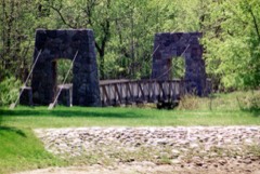 | Old Mill State Park WPA/Rustic Style Historic Resources | under 500 feet | 1989 |
| National Archives record | The nomination case file for reference 73000983 in Record Group 79. |
| Marshall County | All 3 listed properties in this county. |