Block
From the record
24 National Register listings published here.
Sources: the National Register database, National Park Service
38 topographic sheets cover 19 settlements here, and 24 properties are on the National Register of Historic Places.
24 National Register listings published here.
Sources: the National Register database, National Park Service
Every property in this county listed on the National Register of Historic Places, with the year it was listed and the federal nomination document.
Every wildfire the federal occurrence database records inside this county: 10 of them, burning about 224 acres. None started naturally and 2 were recorded as arson. Each settlement page carries the fires within five miles of it.
| Reported cause | Fires |
|---|---|
| Debris and open burning | 3 |
| Missing data/not specified/undetermined | 2 |
| Arson/incendiarism | 2 |
| Fireworks | 2 |
| Recreation and ceremony | 1 |
The five largest, by the area the report gives. Two of them were set deliberately.
| Date | Cause | Size | Reported by | Name on the report |
|---|---|---|---|---|
| 13 April 2003 | Missing data/not specified/undetermined | 150 acres | Minnesota Department of Natural Resources | not named |
| 16 November 2011 | Arson/incendiarism | 37 acres | Minnesota Department of Natural Resources | not named |
| 10 May 2013 | Arson/incendiarism | 15 acres | Minnesota Department of Natural Resources | not named |
| 12 December 2002 | Debris and open burning | 10 acres | Minnesota Department of Natural Resources | not named |
| 6 May 2018 | Missing data/not specified/undetermined | 6.0 acres | Minnesota Department of Natural Resources | not named |
| 6 July 2012 | Fireworks | 2.0 acres | Minnesota Department of Natural Resources | not named |
| 19 December 2006 | Recreation and ceremony | 2.0 acres | Minnesota Department of Natural Resources | not named |
| 15 April 2007 | Debris and open burning | 2.0 acres | Minnesota Department of Natural Resources | not named |
Every settlement page carries the fires within five miles of it - see the settlement index below.
The NOAA Storm Events Database holds 269 reports for this county, causing 2 deaths, 10 injuries and about $131,935,530 in recorded property damage. Each settlement page carries the reports that name it.
| Kind of event | Reports |
|---|---|
| Hail | 110 |
| Thunderstorm Wind | 101 |
| Tornado | 29 |
| Flash Flood | 11 |
| Flood | 6 |
| Heavy Rain | 6 |
| Funnel Cloud | 5 |
| Lightning | 1 |
The most serious of them, by death, then injury, then recorded damage. The accounts are quoted exactly as the forecast office filed them.
| When | Event | Place named | Harm | What the report says |
|---|---|---|---|---|
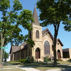
| March 1998 | Tornado (F3) | Nicollet | 1 killed, $120,000,000 | Tornado made a direct hit on the city of St. Peter and Gustavius Adolphus College. All major buildings on campus suffered varying degrees of damage. The spire on Christ Chapel snapped in half. 70% of the windows on campus were broken. 500 homes were destroyed in St. Peter, 1,700 were damaged. Over 1,000 trees uprooted. One person killed just outside St. Peter when the tornado struck a vehicle. St. Peter Catholic Church destroyed. Hospital severely damaged. Roof ripped off library. 25% of books lost. Debris from St. Peter found 50 miles away in southern suburbs of the Twin Cities. 60 rural homes and farms damaged or destroyed from Courtland to St. Peter. Rural damage estimated at 6.5 million. |
| March 2011 | Flood | North Star | 1 killed | Several highways and county roads from North Mankato, northward along the Minnesota River to Le Sueur, Minnesota were impassable due to Spring flooding. Some of the major routes included 169, 22, and 93 and 99. There was one fatality on March 22 when a MNDOT worker tried to clear an ice jam and his Backhoe tipped over and fell into the area where Seven Mile Creek flows into the Minnesota River. |
| August 2006 | Tornado (F3) | Nicollet | 7 hurt, $3,500,000 | The tornado began with a very narrow path and gradually expanded to a half mile wide multiple vortex tornado. One home in Nicollet lost much of its upper floor, and other homes suffered major damage, including some bring shifted off their foundation. The tornado continued east along Highway 99, producing major damage to houses, farm buildings, and a power substation. It did its most severe damage on the southern outskirts of St. Peter, where a house was completely leveled. A total of 57 homes properties in Nicollet County were damaged, and several homes had to be totaled out. A spokesmen from the St. Peter Community Hospital said several persons were admitted with severe wounds, such as broken bones. The tornado crossed the Minnesota River near the southern city limits of St. Peter, and entered Le Sueur County near the city of Kasota (see separate entry). |
| June 1974 | Tornado (F1) | not stated | 3 hurt, $250,000 | no account filed |
| July 1998 | Thunderstorm Wind | Nicollet | $4,000,000 | Roof torn off high school gymnasium resulting in water damage to floor. Garage walls blown down at pair of houses in northwestern part of town. High winds affected 100,000 to 115,000 acres across Nicollet county. 50,000 acres of crops severely damaged. Damage estimate for entire county. Estimated windspeed. |
| June 1952 | Tornado (F2) | not stated | $2,500,000 | no account filed |
| June 2014 | Flood | St George | $500,000 | Several county roads were closed along the Minnesota River where flood waters and resultant mudslides and debris occurred. |
| May 1998 | Thunderstorm Wind | North Mankato | $500,000 | Trees and power lines blown over. Estimated windspeed. Vehicle damage from wind-driven hail. |
| June 1979 | Tornado (F1) | not stated | $250,000 | no account filed |
| May 2012 | Hail | North Mankato | $100,000 | Several spotters and local law enforcement officials reports a swath of very large hail from just west of North Mankato, to approximately 2 miles north of North Mankato. Most of the hail was quarter to half dollar size, but a few reports of tennis ball size hail was noted. |
| June 2004 | Flash Flood | Countywide | $85,000 | Several roads, including Highway 169 between Mankato and St. Peter, were deluged by mudslides and rushing water after up to 6 inches of rain fell. Numerous basements and low lying areas were also flooded. |
| July 2017 | Thunderstorm Wind | Lafayette | $50,000 | A line of severe thunderstorms moved southward across Nicollet County causing damage to a machine shed, and roof damage to a hog barn. A local small wind turbine registered a wind gust of 80 mph. Hundreds of crop acres were damaged by hail throughout the central portion of the county. The largest hail reported was in the Lafayette area, and the city reported the worst tree damage. |
| June 2016 | Thunderstorm Wind | St Peter | $50,000 | A wind sensor on top of the Gustavus Adolphus College science building had a gust of 66 mph. In addition, the St. Peter Catholic Church had their solid brick outside message display knocked down. |
| June 2013 | Thunderstorm Wind | Courtland | $50,000 | A tin roof was blown off a shed, a small shed was blown 300' downwind, and a door was blown off a machine shed. The damage was localized to one part of the barn. |
| July 2020 | Tornado (EF0) | Nicollet | $25,000 | Hundreds of trees were broken or uprooted. Numerous swaths of corn were flattened. Portion of roof were torn off a machine shed. |
| June 2013 | Thunderstorm Wind | North Mankato | $25,000 | Several trees were downed, including one that was uprooted and blocking a street, another that crashed on a house, and several others falling over power lines. |
| May 1977 | Tornado (F1) | not stated | $25,000 | no account filed |
| July 2020 | Thunderstorm Wind | Nicollet | $10,000 | A road sign was damaged and a roof west of Nicollet on Highway 14. |
| September 2025 | Tornado (EF0) | Bernadotte | $5,000 | Satellite and drone imagery confirmed a brief tornado in a cornfield southeast of Lafayette MN. It traveled east for 3.5 miles and damaged the roof of a hog barn and produced crop damage along its path. The tornado was rated EF0. |
| September 2021 | Thunderstorm Wind | Nicollet | $5,000 | Several trees were damaged or uprooted in Nicollet. The highest wind speeds around the area were between 45 and 55 mph. |
| June 1986 | Tornado (F1) | not stated | $2,500 | no account filed |
| May 2012 | Thunderstorm Wind | Lafayette | $2,000 | Severe straight line winds blew down power lines along County Road 1, west of Lafayette, Minnesota. |
| June 1994 | Hail | New Ulm | $500 | Walnut to golf ball-size hail pelted the New Ulm area and across to east side of the Minnesota River near Klossner. |
| July 1994 | Hail | New Ulm | $500 | Nickel-size hail fell in the New Ulm area, from the city to across the Minnesota River 5 E New Ulm. |
| May 1989 | Tornado (F0) | not stated | $30 | no account filed |
| April 2025 | Hail | St Peter | - | Photo measurement provided via X. |
| June 2025 | Tornado (EFU) | Courtland | - | The location and track of this tornado is based on storm chaser video. It moved through fields and across a road without hitting any damage indicators. |
| June 2025 | Tornado (EF0) | Nicollet | - | Approximate track of tornado, based on storm chaser video. The tornado knocked down small branches at a farmstead. Many storm chasers, spotters, and members of the public took photos and video of this tornado. It was highly visible from miles away. |
| July 2025 | Hail | Traverse | - | Quarter to golf ball sized hail. |
| July 2025 | Hail | St Peter | - | Quarter sized hail near the Kwik Trip in St Peter. |
| August 2025 | Heavy Rain | Oshawa | - | Cocorahs station MN-NC-3 St. Peter 6WSW. 72 hour total of 5.00 inches. |
| September 2025 | Tornado (EF0) | Norseland | - | A tornado touched down in a field and hit a farmstead, knocking down and breaking multiple trees across the property. The time was estimated from radar. |
| August 2024 | Funnel Cloud | St George | - | Funnel cloud was reported via spotter network. Time was estimated from radar. |
| August 2024 | Thunderstorm Wind | Klossner | - | County Dispatch reported trees down near the intersection of Co Rd 21 and 611th ave. |
| August 2024 | Thunderstorm Wind | North Mankato | - | County dispatch reported a power line down near the intersection of Webster Ave and Center St. |
| June 2024 | Heavy Rain | St George | - | A total of 3 to 6 inches of rain fell from multiple rounds of thunderstorms. CoCoRaHS observers measured 5.71 inches near North Mankato. |
| August 2023 | Thunderstorm Wind | North Mankato | - | A tree was down on a highway. |
| July 2023 | Thunderstorm Wind | Lafayette | - | A strong line of thunderstorms progressed across Nicollet County where numerous trees downed and flattened corn along a extending line from Lafayette, MN to North Mankato, MN. Local broadcast media provided a photo of a large tree branch down in Spring Lake Park which had been brought down by strong thunderstorm winds. The AWOS observation site located at Mankato Regional Airport recorded a wind gust of 50 mph at 11:56 PM. |
| July 2023 | Thunderstorm Wind | North Mankato | - | Photo of large tree branches downed by strong thunderstorm winds in Spring Lake Park. Mankato Regional Airport reported a 50 mph wind gusts at 11:56 PM. |
| July 2023 | Hail | New Sweden | - | A CoCoRaHS measured golfball size hail. |
| August 2021 | Thunderstorm Wind | Oshawa | - | A trained spotter had a hand held wind sensor that measured 52 knots. |
| August 2021 | Thunderstorm Wind | Courtland | - | A large tree was broken off several feet above its base in Courtland. |
| June 2020 | Flash Flood | Nicollet | - | There were numerous reports of flooded or closed roadways due to water over the road across southern Nicollet County. There were multiple mud slides in the Minnesota River Valley, including one on Highway 169, south of St. Peter. There was also rushing water over 490th street at Highway 14, southeast of Nicollet. |
| July 2020 | Heavy Rain | St Peter | - | A measured rainfall report over the last 24-hours near St. Peter was 8.50 inches. |
| July 2020 | Thunderstorm Wind | Lafayette | - | Several trees were knocked over and many large branches were broken in Lafayette. |
| July 2020 | Flash Flood | North Mankato | - | Both ramps to U.S. 169 in North Mankato were closed at Center Street due to flood waters. |
| July 2020 | Thunderstorm Wind | Nicollet | - | About one dozen large branches were broken. |
| July 2020 | Thunderstorm Wind | Nicollet | - | Several trees were uprooted and numerous large branches were broken. |
| July 2020 | Thunderstorm Wind | Courtland | - | Several large tree branches were blown down in Courtland. |
| March 2019 | Flood | St George | - | Numerous roads were closed for several days due to snow melt, and the flood waters that develop from it. Rapidly runoff led to impassable roads, especially along streams and creeks along county roads. |
| June 2019 | Thunderstorm Wind | North Mankato | - | Several trees were blown down in North Mankato. The Mankato regional airport measured wind gusts of 50 to 55 mph approximately 10-15 minutes later, which is east of North Mankato. |
| June 2019 | Thunderstorm Wind | St Peter | - | A large tree was blown down on Highway 169, north of St. Peter. |
| April 2019 | Flash Flood | North Mankato | - | Heavy rainfall triggered multiple rock and mudslides on Highway 169, between St. Peter and Mankato. The Minnesota Department of Transportation had to close parts of Highway 169 due to debris on the southbound lanes. |
| August 2019 | Funnel Cloud | Bernadotte | - | A funnel cloud was observed for four minutes, but did not touch the ground near Bernadotte. |
| August 2018 | Thunderstorm Wind | St Peter | - | Several trees were blown down north of St. Peter. |
| August 2017 | Tornado (EF0) | Nicollet | - | A tornado developed south of Nicollet and moved north-northwest. It caused mainly tree damage, but did hit a farmstead and damaged a garage and grove of trees. Placement of tornado track was based on high-res satellite imagery. |
| August 2017 | Tornado (EF0) | Nicollet | - | Shortly after one tornado, a second tornado developed south of Nicollet and moved north. It was observed by a local citizen, and a damage survey showed that it caused damage to corn fields. Placement of tornado track was based on high-res satellite imagery. |
| August 2017 | Tornado (EF1) | New Sweden | - | The strongest tornado of the day developed in northern Nicollet County and lifted into|Sibley County. This was a multi-vortex tornado. Video shows one vortex struck a farmstead directly causing significant damage to trees and out buildings. |
| August 2017 | Tornado (EF0) | New Sweden | - | A spotter reported two tornadoes near New Sweden. This tornado was confirmed by viewing high-res satellite imagery. Corn fields were damaged. |
| July 2017 | Tornado (EF0) | Courtland | - | The tornado hit two farms, damaging sheds and other outbuildings. It also moved across fields, damaging crops. Some trees were also knocked down. |
The Survey's mineral resources record lists 3 workings inside this county. All of them still produce. Each settlement page carries the workings within five miles of it.
| Commodity | Workings |
|---|---|
| Sand and Gravel, Construction | 2 |
| Stone, Crushed/Broken | 1 |
The least common of them first, because a county's hundredth gravel pit says nothing its first ten did not.
| Where | Site | Commodity | Status | Recorded |
|---|---|---|---|---|
| New Ulm Quartzite Quarries | Stone, Crushed/Broken | Producer | ||
| Judson Sand Pit | Sand and Gravel, Construction | Producer | ||
| Zimmerman East Pit and Mill | Sand and Gravel, Construction | Producer |
Named settlements recorded in the Geographic Names Information System, each with the topographic sheets covering it. Villages, hamlets and abandoned places alike. Each is shown with the nearest named watercourse or landform and the survey quadrangle it falls on.
Nicollet township · 56074 · Near Dalhman Island · Nicollet quadrangle
9 sheets, 1953 to 1991
Granby township · 56074 · Near Anderson Island · Nicollet quadrangle
9 sheets, 1953 to 1991