 Block
From the record
One of 24 National Register listings published here for Nicollet County · listed in 1983 · category: Building.
Sources: the case file at the National Archives · the National Register database, National Park Service

Listed on the National Register of Historic Places in 1983.
One of 24 National Register listings published here for Nicollet County · listed in 1983 · category: Building.
Sources: the case file at the National Archives · the National Register database, National Park Service
Regional context, not property-specific evidence. The federal wildfire occurrence database lists 2 fires within 5 miles of North Mankato Public School between 2009 and 2013, burning about 6 acres in total. None started naturally. None was recorded as arson. Distance is straight-line from the map coordinates, so a fire counted here may appear on a neighbouring settlement's page as well.
| Reported cause | Fires |
|---|---|
| Railroad operations and maintenance | 1 |
| Fireworks | 1 |
The most recent of them, most recent first, with the day each was reported and the service that recorded it.
| Date | Cause | Size | Reported by | Name on the report |
|---|---|---|---|---|
| 5 July 2013 | Fireworks | 5.0 acres | Minnesota Department of Natural Resources | not named |
| 16 March 2009 | Railroad operations and maintenance | 1.0 acres | Minnesota Department of Natural Resources | not named |
Regional context, not property-specific evidence. The federal mineral resources record lists 11 workings within 5 miles of North Mankato Public School: 8 producers, 3 occurrences. 8 still produce. What was taken out: Stone, Crushed/Broken, Sand and Gravel, Construction, Clay, Limestone, Dimension. Distance is straight-line from the map coordinates, so a quarry counted here may appear on a neighbouring settlement's page as well.
| Where | Site | Commodity | Status | Recorded |
|---|---|---|---|---|
| Blue Earth County Sand Bed | Silica | Occurrence | ||
| Blue Earth County Clay Deposit No 1 | Clay | Occurrence | ||
| Blue Earth County Clay Deposit No 2 | Clay | Occurrence | ||
| Guaranteed Gravel & Sand Pit | Sand and Gravel, Construction | Producer | ||
| Hanel Sand & Gravel Pit | Sand and Gravel, Construction | Producer | ||
| Mankato Stone Center | Limestone, Dimension, Stone, Crushed/Broken | Producer | ||
| Vetter Main Quarry & Mill | Limestone, Dimension | Producer | ||
| Lundin 8th Ave Quarry | Stone, Crushed/Broken | Producer | ||
| Lundin Quarry | Stone, Crushed/Broken | Producer | ||
| Mankago Aglime Quarry | Stone, Crushed/Broken | Producer |
Regional context, not property-specific evidence. The National Weather Service names North Mankato, the town this property stands in, in 35 storm reports between 1995 and 2025: 14 thunderstorm wind, 13 hail, 5 flash flood, 3 heavy rain. No death or injury is recorded in these reports. Each account below is quoted exactly as the forecast office filed it, from the NOAA Storm Events Database, and each date opens the federal record of that event.
| When | Event | Place named | Harm | What the report says |
|---|---|---|---|---|
| May 1998 | Thunderstorm Wind | North Mankato | $500,000 | Trees and power lines blown over. Estimated windspeed. Vehicle damage from wind-driven hail. |
| May 2012 | Hail | North Mankato | $100,000 | Several spotters and local law enforcement officials reports a swath of very large hail from just west of North Mankato, to approximately 2 miles north of North Mankato. Most of the hail was quarter to half dollar size, but a few reports of tennis ball size hail was noted. |
| June 2013 | Thunderstorm Wind | North Mankato | $25,000 | Several trees were downed, including one that was uprooted and blocking a street, another that crashed on a house, and several others falling over power lines. |
| August 2024 | Thunderstorm Wind | North Mankato | - | County dispatch reported a power line down near the intersection of Webster Ave and Center St. |
| August 2023 | Thunderstorm Wind | North Mankato | - | A tree was down on a highway. |
| July 2023 | Thunderstorm Wind | North Mankato | - | Photo of large tree branches downed by strong thunderstorm winds in Spring Lake Park. Mankato Regional Airport reported a 50 mph wind gusts at 11:56 PM. |
| July 2020 | Flash Flood | North Mankato | - | Both ramps to U.S. 169 in North Mankato were closed at Center Street due to flood waters. |
| June 2019 | Thunderstorm Wind | North Mankato | - | Several trees were blown down in North Mankato. The Mankato regional airport measured wind gusts of 50 to 55 mph approximately 10-15 minutes later, which is east of North Mankato. |
| April 2019 | Flash Flood | North Mankato | - | Heavy rainfall triggered multiple rock and mudslides on Highway 169, between St. Peter and Mankato. The Minnesota Department of Transportation had to close parts of Highway 169 due to debris on the southbound lanes. |
| June 2016 | Thunderstorm Wind | North Mankato | - | An eight inch diameter tree was blown down in North Mankato. |
| June 2016 | Heavy Rain | North Mankato | - | A 4 hour rainfall report of 5.75 inches occurred in North Mankato. |
| June 2016 | Flash Flood | North Mankato | - | Several sources indicated that torrential rainfall caused roads to flood across parts of North Mankato during the afternoon of Tuesday, June 14th. Mudslides were noted along the Minnesota River along Highway 169. |
| July 2016 | Thunderstorm Wind | North Mankato | - | A tree was blown down in North Mankato. |
| June 2014 | Heavy Rain | North Mankato | - | There was a 24 hour measured rainfall amount of 3.51 inches in North Mankato. All of the rain fell late on the 17th and during the early morning hours of the 18th. |
| June 2014 | Flash Flood | North Mankato | - | The excessive rainfall caused a mudslide on Highway 169 in North Mankato on Judson Bottom Road, and there were also numerous flooded streets in the city limits of North Mankato. |
| May 2012 | Thunderstorm Wind | North Mankato | - | A large tree was blown down in North Mankato. |
| June 2010 | Hail | North Mankato | - | Several reports of quarter size hail occurred along Highway 169, north of Mankato, Minnesota, with drifts up to two feet reported along the road side. |
| May 2005 | Thunderstorm Wind | North Mankato | - | A wind gust of 59 MPH was recorded by a spotter just outside of town. Small trees were downed in the vicinity. |
| May 2005 | Hail | North Mankato | - | A trained spotter reported penny sized hail. |
| June 2005 | Thunderstorm Wind | North Mankato | - | A tree was downed. |
| August 2005 | Thunderstorm Wind | North Mankato | - | Six inch branches were downed. A wind gust of 57 MPH was measured elsewhere in town by a trained spotter. |
| September 2005 | Heavy Rain | North Mankato | - | A total of 1.35 inches of rain fell in 35 minutes. Minor street flooding was reported in poor drainage areas. |
| July 2003 | Thunderstorm Wind | North Mankato | - | Several trees down, including one across a road. |
| May 1998 | Hail | North Mankato | - | Occurred at television station. |
| July 1997 | Thunderstorm Wind | North Mankato | - | Shed blown over. Estimated windspeed. |
| June 1995 | Hail | North Mankato | - | ,Dime-sized hail and 50 mph winds reported at KEYC-TV. |
| August 2025 | Hail | North Mankato | - | no account filed |
| April 2022 | Hail | North Mankato | - | no account filed |
| June 2020 | Hail | North Mankato | - | no account filed |
| August 2004 | Hail | North Mankato | - | no account filed |
| July 2000 | Hail | North Mankato | - | no account filed |
| May 1998 | Hail | North Mankato | - | no account filed |
| May 1998 | Hail | North Mankato | - | no account filed |
| September 1996 | Flash Flood | North Mankato | - | no account filed |
| July 1995 | Hail | North Mankato | - | no account filed |
No historic map-sheet match is published for this property yet. That does not mean no map exists. This record needs a coordinate-quality review before it can be joined to a sheet boundary. Browse the county's mapped places while that work is pending.
Other National Register properties close enough to walk or drive between, ordered by distance from this one. Both positions come from the same geocoding pass that matched these properties to their map sheets.
| Photograph | Property | Distance | Listed |
|---|---|---|---|
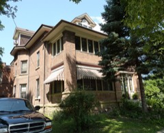 | William E. Stewart House | 0.4 miles | 1984 |
| National Archives record | The nomination case file for reference 83000919 in Record Group 79. |
| Nicollet County | All 24 listed properties in this county. |