 Block
From the record
4 National Register listings published here.
Sources: the National Register database, National Park Service
31 topographic sheets cover 21 settlements here, and 4 properties are on the National Register of Historic Places.
4 National Register listings published here.
Sources: the National Register database, National Park Service
Every property in this county listed on the National Register of Historic Places, with the year it was listed and the federal nomination document.
| Photograph | Property | Type | Listed | Reference |
|---|---|---|---|---|
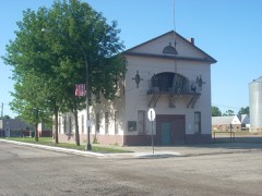 | Ada Village Hall | building | 1998 | 98000154 |
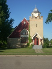 | Congregational Church of Ada | building | 1984 | 84000236 |
 | Norman County Courthouse | building | 1983 | 83000923 |
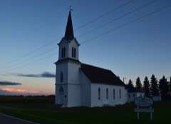 | Zion Lutheran Church | building | 1999 | 99001269 |
Every wildfire the federal occurrence database records inside this county: 18 of them, burning about 6,098 acres. None started naturally and 10 were recorded as arson. Each settlement page carries the fires within five miles of it.
| Reported cause | Fires |
|---|---|
| Arson/incendiarism | 10 |
| Debris and open burning | 4 |
| Missing data/not specified/undetermined | 3 |
| Equipment and vehicle use | 1 |
The five largest, by the area the report gives. Two of them were set deliberately.
| Date | Cause | Size | Reported by | Name on the report |
|---|---|---|---|---|
| 21 April 2010 | Arson/incendiarism | 2,425 acres | Minnesota Department of Natural Resources | not named |
| 1 December 2011 | Debris and open burning | 1,540 acres | Minnesota Department of Natural Resources | NEAL WMA |
| 22 April 2016 | Missing data/not specified/undetermined | 640 acres | Minnesota Department of Natural Resources | not named |
| 23 April 2015 | Equipment and vehicle use | 631 acres | Minnesota Department of Natural Resources | not named |
| 11 April 2015 | Debris and open burning | 299 acres | Minnesota Department of Natural Resources | not named |
| 31 March 2015 | Debris and open burning | 169 acres | Minnesota Department of Natural Resources | not named |
| 6 May 2011 | Debris and open burning | 140 acres | Glacial Ridge | GODFREY 14 |
| 14 May 2008 | Arson/incendiarism | 115 acres | Minnesota Department of Natural Resources | not named |
Every settlement page carries the fires within five miles of it - see the settlement index below.
The NOAA Storm Events Database holds 344 reports for this county, causing 3 deaths, 35 injuries and about $29,598,000 in recorded property damage. Each settlement page carries the reports that name it.
| Kind of event | Reports |
|---|---|
| Hail | 153 |
| Thunderstorm Wind | 131 |
| Tornado | 30 |
| Flash Flood | 12 |
| Flood | 12 |
| Funnel Cloud | 6 |
The most serious of them, by death, then injury, then recorded damage. The accounts are quoted exactly as the forecast office filed them.
| When | Event | Place named | Harm | What the report says |
|---|---|---|---|---|
| July 1978 | Tornado (F2) | not stated | 3 killed, 35 hurt, $25,000,000 | no account filed |
| April 2006 | Flood | Countywide | $1,320,000 | The Red River at Halstad (MN) rose above flood stage around 4 PM CST on March 31st and remained above flood stage until around 3 AM CST on April 17th. The river peaked at roughly 39.31 feet around 8 PM CST on April 6th. Unofficially, 39.31 feet would be the third highest modern-day river stage recorded. The second highest modern-day river stages (unofficial) were recorded on the Wild Rice River at Hendrum (32.39 feet on April 5th) and on the Marsh River at Shelly (25.03 feet on April 3rd). Overland flooding also occurred in addition to the river flooding, with over 75 roads around the county closed due to flooding. Red River bridges at Perley (MN), Hendrum (MN), and Shelly (MN) were all closed. This left the State Highway 200 bridge as the only open Red River bridge between Fargo/Moorhead and Grand Forks/East Grand Forks. U.S. Highway 75 was closed in spots in western Norman County. Roads were also closed south and west of Ada. East of Perley and Hendrum, water completely covered at least a dozen sections of land, stranding several herds of cattle. The Minnesota Governor authorized the National Guard to assist in the flood fight, working on dike patrols, security, and traffic control. Classes were cancelled from April 3rd through the 5th at Norman County West School in Halstad, for flood fighting and to make room for the Minnesota Guard troops. A mile south of Halstad, a woman drove around a barricaded (flooded) road and was swept off the road and into a nearby flooded farm field. Two people passing by rushed to her aid and rescued her. All 3 people suffered minor hypothermia from being in the cold water. After the spring flood of 1997, many communities along the Red River looked at ways to mitigate flood effects. Permanent dikes held in the Halstad and Hendrum, so most of the flood fighting took place at rural farmsteads. Norman County received a Presidential Disaster Declaration for damages caused by spring flooding.In summary, the total public and private flood losses experienced within the Red River of the North basin through late March and April 2006 were likely in excess of $20 million. This includes the following amounts. For Minnesota state and local infrastructure (this total includes the damages listed for each county), $8.5 million. For North Dakota state and local infrastructure (this total includes the damages listed for each county), $8 million. For Federal agencies (USACE, USGS, and USCG), $1.5 million. For the transportation industry costs due to traffic diversions caused by prolonged road and bridge closures, $1.5 million. For personal property losses due to floodwaters surrounding more than 500 individual farmsteads and rural homesteads, $1.0 million. |
| June 2000 | Flash Flood | Ada | $1,000,000 | Numerous county and township roads were washed out from the heavy rain. Street flooding was reported in both Ada and Gary. |
| July 2017 | Tornado (EF2) | Halstad | $550,000 | This tornado originated 4 miles east-northeast of Hillsboro, in Traill County, North Dakota, at 648 pm CST. It crossed the Red River about one mile west of Halstad. The tornado snapped H-pole power poles, crushed steel grain bins, snapped numerous oak and ash trees, and toppled a barn along its path. Peak winds were estimated at 130 mph. |
| July 2017 | Tornado (EF2) | Wheatville | $450,000 | This tornado collapsed at least one shed, snapped numerous trees, and tossed large round hay bales across a sugar beet field. It also snapped at least a half dozen wooden power poles. Peak winds were estimated at 125 mph. The tornado continued into Clay County, where it ended two miles north of Ulen, at 806 pm CST. |
| May 2011 | Thunderstorm Wind | Halstad | $300,000 | Numerous trees were blown down in farmsteads and communities across western Norman County. In Halstad and Ada, broken tree limbs crushed vehicles and severly damaged roofing on numerous homes. |
| June 2008 | Thunderstorm Wind | Ada | $200,000 | Power was out in the Ada area with damaged transformers and trees down. |
| June 2008 | Thunderstorm Wind | Hendrum | $100,000 | The wind damaged local transformers and knocked out the power. |
| June 2002 | Thunderstorm Wind | Twin Vly | $100,000 | Steel power transmission poles were blown down. |
| July 2017 | Thunderstorm Wind | Borup | $50,000 | The roof was blown off a pole shed and large trees were uprooted. |
| July 2008 | Hail | Flom | $50,000 | The hail caused extensive crop damage. |
| July 1999 | Thunderstorm Wind | Ada | $50,000 | The strong wind peeled off the roof on the city's public works building. Debris from the falling roof damaged 4 vehicles inside. Another city building was also damaged, as well as many trees around town. |
| April 2019 | Flood | Shelly | $50,000 | no account filed |
| September 1996 | Thunderstorm Wind | Faith | $50,000 | no account filed |
| June 2008 | Tornado (EF1) | Halstad | $40,000 | A persistent rotating wall cloud produced a short lived funnel and brief tornado. Some metal roofing was torn off a farm building and several 8 to 10 inch diameter trees were snapped off at one farmstead. Peak winds were estimated at 90 mph. |
| April 1974 | Tornado (F1) | not stated | $25,000 | no account filed |
| April 2022 | Flash Flood | Hendrum | $20,000 | Water from local runoff of from 2 to 3 inches of heavy rain and from the snowmelt swollen Wild Rice River spilled over Highway 75, south of Hendrum. |
| June 2008 | Hail | Ranum | $20,000 | Penny sized hail covered the deck and did a lot of damage to the local crops. Wind gusts reached up to fifty miles per hour. |
| July 2008 | Thunderstorm Wind | Ada | $20,000 | Corn fields were churned and flattened by strong winds. |
| June 2002 | Tornado (F1) | Ada | $20,000 | A roof was torn off a farm building and scattered in nearby trees. |
| June 2002 | Thunderstorm Wind | Gary | $20,000 | A church steeple was blown off. |
| July 2001 | Thunderstorm Wind | Halstad | $20,000 | Power poles were blown down. |
| August 2001 | Thunderstorm Wind | Hendrum | $20,000 | Trees and powerlines were blown down causing a power outage of 12 hours. |
| August 2001 | Thunderstorm Wind | Halstad | $20,000 | Numerous trees and powerlines were blown down and the roof was torn off a potato warehouse. |
| July 2001 | Thunderstorm Wind | Ada | $20,000 | Large branches were blown down in Ada. |
| July 2001 | Thunderstorm Wind | Twin Vly | $20,000 | Branches were blown down in Twin Valley. |
| October 1997 | Thunderstorm Wind | Hendrum | $10,000 | The strong wind blew the roof off a school bus garage. |
| May 2013 | Flood | Syre | $5,000 | Several sections of farm fields and portions of township roads were flooded. |
| June 2008 | Hail | Borup | $5,000 | Dime to nickel sized hail covered the ground in spots. |
| August 2001 | Flash Flood | Ada | $5,000 | Basement flooding was reported. |
| March 2009 | Flood | Shelly | $5,000 | no account filed |
| April 2009 | Flood | Shelly | $5,000 | no account filed |
| June 2014 | Thunderstorm Wind | Shelly | $4,000 | A few 8 inch diameter trees were snapped near the ground in a cemetary. |
| June 2002 | Thunderstorm Wind | Ada | $3,000 | Trees were blown down and a window was blown out. |
| June 2002 | Thunderstorm Wind | Ada | $3,000 | Trees were blown down in Ada. |
| June 1981 | Tornado (F0) | not stated | $2,500 | no account filed |
| September 2017 | Tornado (EF1) | Lockhart | $2,000 | This tornado began in Norman County, Minnesota, about three miles north-northeast of Lockhart. It tracked about a mile in Norman County, before it crossed into Polk County, where it continued about another three miles. The tornado ended at 701 PM CST, just past the community of Beltrami, Polk County. Peak winds were estimated at 105 mph. |
| May 2013 | Thunderstorm Wind | Flaming | $2,000 | Several pine and poplar trees were either snapped off near the ground or had large four to six inch diameter branches broken off. |
| June 2010 | Flash Flood | Perley | $2,000 | Rainfall amounts of 4 to 5 inches produced widespread flooding of fields and farm access roads across southern portions of Mary Township. |
| July 2008 | Thunderstorm Wind | Flom | $2,000 | Several large branches were blow down in a shelter belt. |
| July 1997 | Thunderstorm Wind | Ada | $2,000 | Several large trees were uprooted due to the strong wind. |
| July 1997 | Thunderstorm Wind | Twin Vly | $2,000 | Large trees were blown over due to the strong wind. |
| August 2016 | Flash Flood | Flaming | $500 | Four to eight inches of rain fell in about two hours across eastern Spring Creek and Sundal townships, resulting in flooded fields and farm access roads. |
| August 2002 | Thunderstorm Wind | Ranum | $500 | Large trees were blown down. |
| August 2001 | Thunderstorm Wind | Gary | $500 | Branches were blown down. |
| August 2001 | Thunderstorm Wind | Borup | $500 | Branches were blown down. |
| August 2001 | Thunderstorm Wind | Borup | $500 | Branches were blown down. |
| June 1999 | Thunderstorm Wind | Ada | $500 | Several trees were knocked down near Ada. |
| June 1999 | Thunderstorm Wind | Ada | $500 | Trees were blown over in Ada. A power pole was also blown over west of town, knocking out power to the western half of the county for 7 hours. |
| May 2025 | Thunderstorm Wind | Flom | - | Large tree limbs blown down. |
| August 2025 | Thunderstorm Wind | Flom | - | Report of tree damage. Time estimated from radar. |
| June 2025 | Thunderstorm Wind | Ada | - | Measured gust at NDAWN mesonet station 210019 1 north Ada MN. |
| June 2025 | Thunderstorm Wind | Hadler | - | Measured gust at mesonet station 2438D Hadler MN. |
| June 2025 | Thunderstorm Wind | Perley | - | Measured gust at NDAWN mesonet station 216419 east of Perley MN. |
| June 2025 | Thunderstorm Wind | Waukon | - | Measured gust at NDAWN mesonet station 215012 Waukon MN. |
| June 2025 | Thunderstorm Wind | Perley | - | Measured gust at NDAWN mesonet station 216419 6 miles east of Perley, MN. |
| July 2025 | Tornado (EF1) | Lockhart | - | A tornado tracked NW to SE with a final S push as it occluded. It tracked for about 5.3 miles, starting in Polk County, then continuing into Norman County. After crossing into Norman County, this tornado scoured a soybean/corn field before doing damage to some farm outbuildings. This track may be adjusted pending high resolution satellite imagery. UPDATE 7/22: Track adjusted based on Sentinel-2 imagery. EF0 damage was noted in Polk County, with EF1 damage in Norman County. |
| June 2024 | Thunderstorm Wind | Ada | - | Measured gust at the Ada NDAWN 10 foot sensor. |
| June 2024 | Thunderstorm Wind | Gary | - | Public relays report of mature choke cherry tree blown down. |
| June 2024 | Hail | Flaming | - | Broadcast Media relays report of golf ball sized hail east of Lockhart. Hail damage to the house, and 2 windows blown out. |
The Survey's mineral resources record lists 6 workings inside this county. 5 still produce and 1 is closed or unrecorded. Each settlement page carries the workings within five miles of it.
| Commodity | Workings |
|---|---|
| Sand and Gravel, Construction | 6 |
The least common of them first, because a county's hundredth gravel pit says nothing its first ten did not.
| Where | Site | Commodity | Status | Recorded |
|---|---|---|---|---|
| Anderson Pit | Sand and Gravel, Construction | Past Producer | ||
| Cecil Black Pit | Sand and Gravel, Construction | Producer | ||
| Jackson Gravel Pit | Sand and Gravel, Construction | Producer | ||
| Kitchell Pit | Sand and Gravel, Construction | Producer | ||
| Kitchell Pit and Mill | Sand and Gravel, Construction | Producer | ||
| Sletten Pit and Mill | Sand and Gravel, Construction | Producer |
Named settlements recorded in the Geographic Names Information System, each with the topographic sheets covering it. Villages, hamlets and abandoned places alike. Each is shown with the nearest named watercourse or landform and the survey quadrangle it falls on.
Wild Rice township · 56584 · On Mashaug Creek · Twin Valley quadrangle
10 sheets, 1918 to 1984