 Block
From the record
One of 6 National Register listings published here for Stevens County · listed in 2003 · category: District.
Sources: the case file at the National Archives · the National Register database, National Park Service

Listed on the National Register of Historic Places in 2003.
One of 6 National Register listings published here for Stevens County · listed in 2003 · category: District.
Sources: the case file at the National Archives · the National Register database, National Park Service
Regional context, not property-specific evidence. The federal wildfire occurrence database lists 3 fires within 5 miles of West Central School of Agriculture and Experiment Station Historic District between 2002 and 2009, burning about 81 acres in total. None started naturally. 1 was recorded as arson. Distance is straight-line from the map coordinates, so a fire counted here may appear on a neighbouring settlement's page as well.
| Reported cause | Fires |
|---|---|
| Smoking | 2 |
| Arson/incendiarism | 1 |
The most recent of them, most recent first, with the day each was reported and the service that recorded it.
| Date | Cause | Size | Reported by | Name on the report |
|---|---|---|---|---|
| 11 July 2009 | Smoking | 1.0 acres | Morris National Wildlife Refuge | YETTIE |
| 22 March 2003 | Arson/incendiarism | 25 acres | Minnesota Department of Natural Resources | not named |
| 23 November 2002 | Smoking | 55 acres | Minnesota Department of Natural Resources | not named |
Regional context, not property-specific evidence. The federal mineral resources record lists 1 working within 5 miles of West Central School of Agriculture and Experiment Station Historic District: 1 producer. All of them still produce. What was taken out: Sand and Gravel, Construction. Distance is straight-line from the map coordinates, so a quarry counted here may appear on a neighbouring settlement's page as well.
| Where | Site | Commodity | Status | Recorded |
|---|---|---|---|---|
| Schmidgall S and G Pit | Sand and Gravel, Construction | Producer |
Regional context, not property-specific evidence. The National Weather Service names Morris, the town this property stands in, in 63 storm reports between 1996 and 2025: 36 hail, 22 thunderstorm wind, 2 flash flood, 1 tornado. No death or injury is recorded in these reports. Each account below is quoted exactly as the forecast office filed it, from the NOAA Storm Events Database, and each date opens the federal record of that event.
| When | Event | Place named | Harm | What the report says |
|---|---|---|---|---|
| July 2023 | Thunderstorm Wind | Morris | $5,000,000 | There were several trees down in town and areas without power. An apartment building in town had a window blown out. There were also reports of trees down across other parts of the county. |
| May 2022 | Thunderstorm Wind | Morris | $25,000 | Several power poles and trees were either uprooted or blown down in Morris. |
| July 2018 | Thunderstorm Wind | Morris | $20,000 | A 90 foot long portion of a tin, and wood roof from a gas station, was blown off in Morris. There were also power lines blown down around the city. |
| July 2015 | Thunderstorm Wind | Morris | $1,000 | A snowmobile trailer was blown into a roadway behind a local business in Morris. |
| June 2025 | Thunderstorm Wind | Morris | - | An old section of the Highway Department building roof was blown back. Thunderstorm winds estimated to be 70 mph. |
| June 2025 | Thunderstorm Wind | Morris | - | Thunderstorm winds estimated at 70 mph snapped two power poles along Highway 9. Young corn stalks were also damaged. Damage to more power poles, trees and some outbuildings continued across much of northeastern Stevens County. |
| June 2025 | Thunderstorm Wind | Morris | - | Thunderstorm winds estimated at 60 mph snapped off 10 to 16 inch diameter trees and various limbs at a residence north of Morris along Hwy 59. |
| May 2022 | Thunderstorm Wind | Morris | - | A farm shed was destroyed. |
| May 2022 | Thunderstorm Wind | Morris | - | A few large trees were blown down near Morris. |
| May 2022 | Thunderstorm Wind | Morris | - | Several large trees were uprooted northeast of Morris. |
| July 2020 | Thunderstorm Wind | Morris | - | A large tree was blown down across Highway 3, east of Morris. |
| September 2017 | Thunderstorm Wind | Morris | - | Dozens of trees were damaged, shingled were blown off a house, a flag pole was bent, antennas were damaged on a radio tower, and a pump station at a co-op was blown over. There were also scattered trees down in the city of Morris. Based on radar, it is possible that this may have been tornado damage, but the report came in days later and by that time, the damage had been cleaned up and therefore a damage survey was not conducted. |
| June 2013 | Flash Flood | Morris | - | Several city roads became flooded due to high rainfall rates, poor drainage, and recent rainfall of 3 to 6 inches that occurred earlier in the day. |
| June 2013 | Heavy Rain | Morris | - | Storm total rainfall amount of 5.60 inches was measured near Morris. |
| June 2013 | Flash Flood | Morris | - | Very heavy rainfall began across Stevens County after 1130 PM CST, Thursday, June 20th. Due to the extreme rainfall rates that continued through 1230 AM CST, Friday, June 21st, several roads in the city of Morris became inundated with flood waters. |
| July 2011 | Thunderstorm Wind | Morris | - | Several large tree branches were blown down near Morris, Minnesota. |
| August 2010 | Thunderstorm Wind | Morris | - | Several large tree limbs were blown down near Morris, Minnesota, and a measured wind gust of 60 mph occurred at the Morris airport. |
| May 2008 | Tornado (EF0) | Morris | - | Brief touchdown in open field. Multiple eyewitnesses. |
| June 2007 | Hail | Morris | - | Reported on U.S. Highway 59. |
| May 2006 | Hail | Morris | - | Hail covered the ground. |
| July 2006 | Hail | Morris | - | Hail occurred along Highway 59. |
| June 2005 | Thunderstorm Wind | Morris | - | A tree was downed. |
| June 2005 | Thunderstorm Wind | Morris | - | Power lines were downed. |
| August 1999 | Thunderstorm Wind | Morris | - | Estimated winds. Roof partially off barn. Large branches down. |
| July 1999 | Thunderstorm Wind | Morris | - | Estimated winds. Trees felled. One vehicle damaged. |
| July 1998 | Thunderstorm Wind | Morris | - | Tree blown down on University campus. Estimated windspeed. |
| June 1997 | Thunderstorm Wind | Morris | - | Trees blown down. Estimated windspeed. |
| July 2025 | Hail | Morris | - | no account filed |
| June 2025 | Hail | Morris | - | no account filed |
| May 2022 | Hail | Morris | - | no account filed |
| June 2017 | Hail | Morris | - | no account filed |
| September 2017 | Hail | Morris | - | no account filed |
| June 2016 | Hail | Morris | - | no account filed |
| July 2016 | Hail | Morris | - | no account filed |
| September 2014 | Hail | Morris | - | no account filed |
| August 2013 | Hail | Morris | - | no account filed |
| August 2013 | Hail | Morris | - | no account filed |
| August 2012 | Hail | Morris | - | no account filed |
| August 2012 | Hail | Morris | - | no account filed |
| August 2012 | Hail | Morris | - | no account filed |
| August 2012 | Hail | Morris | - | no account filed |
| July 2010 | Funnel Cloud | Morris | - | no account filed |
| August 2009 | Hail | Morris | - | no account filed |
| August 2009 | Thunderstorm Wind | Morris | - | no account filed |
| May 2008 | Hail | Morris | - | no account filed |
| June 2007 | Hail | Morris | - | no account filed |
| June 2007 | Hail | Morris | - | no account filed |
| August 2007 | Hail | Morris | - | no account filed |
| April 2007 | Hail | Morris | - | no account filed |
| April 2007 | Hail | Morris | - | no account filed |
| June 2005 | Hail | Morris | - | no account filed |
| June 2005 | Hail | Morris | - | no account filed |
| May 2004 | Hail | Morris | - | no account filed |
| July 2003 | Hail | Morris | - | no account filed |
| June 2003 | Hail | Morris | - | no account filed |
| July 2002 | Hail | Morris | - | no account filed |
| June 2002 | Hail | Morris | - | no account filed |
| June 2001 | Hail | Morris | - | no account filed |
| August 1999 | Hail | Morris | - | no account filed |
| June 1998 | Thunderstorm Wind | Morris | - | no account filed |
No historic map-sheet match is published for this property yet. That does not mean no map exists. This record needs a coordinate-quality review before it can be joined to a sheet boundary. Browse the county's mapped places while that work is pending.
Other National Register properties close enough to walk or drive between, ordered by distance from this one. Both positions come from the same geocoding pass that matched these properties to their map sheets.
| Photograph | Property | Distance | Listed |
|---|---|---|---|
 | Morris Industrial School for Indians Dormitory | under 500 feet | 1984 |
| Morris High School | 0.3 miles | 2004 | |
 | Morris Carnegie Library | 0.8 miles | 1983 |
 | Lewis H. Stanton House | 1.1 miles | 1982 |
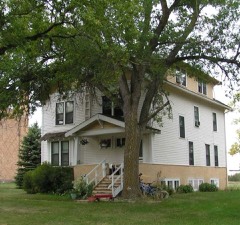 | Alberta Teachers House | 7.2 miles | 1983 |
| National Archives record | The nomination case file for reference 02001707 in Record Group 79. |
| Stevens County | All 6 listed properties in this county. |