 Block
From the record
6 National Register listings published here.
Sources: the National Register database, National Park Service
26 topographic sheets cover 5 settlements here, and 6 properties are on the National Register of Historic Places.
6 National Register listings published here.
Sources: the National Register database, National Park Service
Every property in this county listed on the National Register of Historic Places, with the year it was listed and the federal nomination document.
| Photograph | Property | Type | Listed | Reference |
|---|---|---|---|---|
 | Alberta Teachers House | building | 1983 | 83000942 |
 | Morris Carnegie Library | building | 1983 | 83000943 |
| Morris High School | site | 2004 | 04000532 | |
 | Morris Industrial School for Indians Dormitory | building | 1984 | 84001696 |
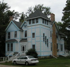 | Lewis H. Stanton House | building | 1982 | 82003060 |
 | West Central School of Agriculture and Experiment Station Historic District | district | 2003 | 02001707 |
Every wildfire the federal occurrence database records inside this county: 24 of them, burning about 956 acres. None started naturally and 1 was recorded as arson. Each settlement page carries the fires within five miles of it.
| Reported cause | Fires |
|---|---|
| Missing data/not specified/undetermined | 13 |
| Debris and open burning | 6 |
| Smoking | 2 |
| Recreation and ceremony | 1 |
| Arson/incendiarism | 1 |
| Equipment and vehicle use | 1 |
The five largest, by the area the report gives. None of them was recorded as arson.
| Date | Cause | Size | Reported by | Name on the report |
|---|---|---|---|---|
| 3 May 2005 | Debris and open burning | 257 acres | Minnesota Department of Natural Resources | not named |
| 11 May 2013 | Debris and open burning | 126 acres | Morris National Wildlife Refuge | GEISE WILDFIRE |
| 6 April 2004 | Missing data/not specified/undetermined | 100 acres | Morris National Wildlife Refuge | DONNELLY |
| 8 November 2005 | Missing data/not specified/undetermined | 92 acres | Morris National Wildlife Refuge | BIG STONE WPA |
| 11 April 2003 | Missing data/not specified/undetermined | 80 acres | Morris National Wildlife Refuge | LANDERS WPA |
| 8 November 1999 | Missing data/not specified/undetermined | 55 acres | Morris National Wildlife Refuge | BIG STONE |
| 23 November 2002 | Smoking | 55 acres | Minnesota Department of Natural Resources | not named |
| 1 May 2003 | Missing data/not specified/undetermined | 50 acres | Morris National Wildlife Refuge | MOSQUITO RANCH WPA |
Every settlement page carries the fires within five miles of it - see the settlement index below.
The NOAA Storm Events Database holds 259 reports for this county, causing no deaths, no injuries and about $12,330,000 in recorded property damage. Each settlement page carries the reports that name it.
| Kind of event | Reports |
|---|---|
| Hail | 129 |
| Thunderstorm Wind | 95 |
| Tornado | 18 |
| Funnel Cloud | 7 |
| Flash Flood | 5 |
| Flood | 3 |
| Heavy Rain | 2 |
The most serious of them, by death, then injury, then recorded damage. The accounts are quoted exactly as the forecast office filed them.
| When | Event | Place named | Harm | What the report says |
|---|---|---|---|---|
| July 2023 | Thunderstorm Wind | Morris | $5,000,000 | There were several trees down in town and areas without power. An apartment building in town had a window blown out. There were also reports of trees down across other parts of the county. |
| April 1984 | Tornado (F1) | not stated | $2,500,000 | no account filed |
| April 1984 | Tornado (F2) | not stated | $2,500,000 | no account filed |
| May 2022 | Thunderstorm Wind | Morris Arpt | $500,000 | Several airport hangers with blown in and some had walls collapsed at the Morris airport. |
| April 2001 | Flash Flood | Countywide | $300,000 | no account filed |
| May 2022 | Thunderstorm Wind | Chokio | $250,000 | Significant infrastructure was either damaged or destroyed in the city of Chokio. This included power poles and trees snapped at their base. Some of the trees landed on houses. |
| August 1973 | Tornado (F1) | not stated | $250,000 | no account filed |
| April 1970 | Tornado (F1) | not stated | $250,000 | no account filed |
| April 2023 | Flood | Donnelly | $146,000 | A combination of record setting seasonal snowfall, high snow water equivalent values, and rapid snow melt led to low lying areas, ditches, and ravines across the county to flood for a prolonged period of time. Road infrastructure such as bridges, gravel roads, and culverts experience varied degrees of damage caused by rapid runoff. Stevens County Emergency Management reported $145,700 in damages to roads and bridges. |
| July 2020 | Thunderstorm Wind | Donnelly | $100,000 | A storm survey that was conducted by the local emergency manager, and storm chasers, concluded that a downburst caused wind damage from 4 miles southwest of Donnelly, to 2 miles northeast of Donnelly. The damage field was 1/2 mile wide and all the damage was to the east/northeast. All the damage outside of Donnelly was scattered trees blown down and some crop damage. There were multiple buildings in the town of Donnelly that had damage. Some siding and many shingles were blown off downtown structures. Some trees fell onto houses and buildings. Two metal buildings had their tin roofs partially removed and one had a steel garage door blown in. |
| July 2019 | Hail | Chokio | $100,000 | A swath of large hail, up to golf ball size, occurred from northwest of Chokio, to Donnelly. There were reports of larger hail, but no pictures were available. Damage occurred to vehicles, buildings (siding, rain gutters & shingles), and crops. |
| May 2022 | Thunderstorm Wind | Alberta | $50,000 | A grain silo was destroyed south of Alberta. |
| July 2020 | Thunderstorm Wind | Chokio | $50,000 | A swath of wind damage extended 3/4 of a mile to the southeast of Chokio, including parts of Chokio. The damage area was about 1/4 of a mile wide, with many trees snapped off just above the base, while others were uprooted. A light tower of a local baseball field was blown over. |
| July 2019 | Hail | Donnelly | $50,000 | The swath of large hail continued through the rest of Stevens County to the Douglas County line. The largest hail stone measured was golf ball size. |
| July 2002 | Thunderstorm Wind | Chokio | $50,000 | Ten mile long path of wind damage. Numerous trees down, one on a van. Silos, several sheds, and grain bins down. Maximum wind gust of 78 knots measured at Morris Airport. |
| March 2010 | Flood | Alberta | $40,000 | Numerous counties roads were flooded from snow melt and associated runoff along several tributaries of the Minnesota River, in Stevens County. Monetary costs were based on FEMA, State, and Local assistance which includes the following categories; debris removal, emergency protective measures, and road systems and bridges. |
| May 2022 | Thunderstorm Wind | Morris Arpt | $30,000 | Utilities reported a loss of $30,000 due to downed power poles. |
| May 2022 | Thunderstorm Wind | Morris | $25,000 | Several power poles and trees were either uprooted or blown down in Morris. |
| May 2022 | Thunderstorm Wind | Alberta | $25,000 | A large storage shed was destroyed near Alberta along with a few large trees blown down. An outbuilding was blown about 100 yards. |
| July 1978 | Tornado (F0) | not stated | $25,000 | no account filed |
| June 1975 | Tornado (F0) | not stated | $25,000 | no account filed |
| August 1952 | Tornado (F1) | not stated | $25,000 | no account filed |
| July 2018 | Thunderstorm Wind | Morris | $20,000 | A 90 foot long portion of a tin, and wood roof from a gas station, was blown off in Morris. There were also power lines blown down around the city. |
| July 2001 | Thunderstorm Wind | Alberta | $10,000 | Grain bin dented, roof off pole barn. |
| May 2022 | Thunderstorm Wind | Chokio | $5,000 | Power lines were blown down west of Chokio. |
| August 1966 | Tornado | not stated | $2,500 | no account filed |
| July 2015 | Thunderstorm Wind | Morris | $1,000 | A snowmobile trailer was blown into a roadway behind a local business in Morris. |
| May 2011 | Thunderstorm Wind | Chokio | $500 | Minor damage occurred to a machine shed door as winds gusted to 60 mph. |
| June 2025 | Thunderstorm Wind | Morris | - | An old section of the Highway Department building roof was blown back. Thunderstorm winds estimated to be 70 mph. |
| June 2025 | Thunderstorm Wind | Morris | - | Thunderstorm winds estimated at 70 mph snapped two power poles along Highway 9. Young corn stalks were also damaged. Damage to more power poles, trees and some outbuildings continued across much of northeastern Stevens County. |
| June 2025 | Thunderstorm Wind | Morris | - | Thunderstorm winds estimated at 60 mph snapped off 10 to 16 inch diameter trees and various limbs at a residence north of Morris along Hwy 59. |
| July 2025 | Flash Flood | Chokio | - | A period of training thunderstorms produced heavy rainfall that quickly accumulated water up to a foot and a half deep over roadways in Chokio. |
| July 2025 | Flash Flood | Alberta | - | Training thunderstorms produced heavy rainfall which led to multiple roads being under water in Alberta. |
| July 2025 | Thunderstorm Wind | Chokio | - | Power poles down in Chokio. |
| July 2024 | Hail | Chokio | - | The hail was placed next to a quarter and photographed. |
| July 2024 | Thunderstorm Wind | Chokio | - | A few tree branches up to 4 inches in diameter were down. |
| July 2024 | Hail | Donnelly | - | Reported through mPing. |
| July 2024 | Hail | Donnelly | - | Reported via mPing. |
| July 2024 | Hail | Chokio | - | A hailstone measuring six inches in diameter was reported by a resident to emergency management. The hail next to a ruler were photographed. This at least tied the record for the largest hailstone in Minnesota. Storm Data records also indicate six inch diameter hail in Nobles County on July 28, 1986, and in Murray County on July 4, 1968. The hail was collected about 13 to 15 minutes after the hail ended but was not saved in a freezer. |
| July 2024 | Hail | Chokio | - | A hailstone measuring six inches in diameter was reported by a resident to emergency management. The hail and ruler were photographed. |
| June 2024 | Hail | Chokio | - | There were several reports of dime to nickel sized hail in southwest Stevens County. |
| June 2023 | Heavy Rain | Chokio | - | A trained spotter measured 5.00 inches of rain in Chokio MN, which caused some ponding of water. |
| July 2023 | Thunderstorm Wind | Chokio | - | Several trees and branches of 6 to 10 inches were reported down in the city of Chokio. |
| July 2023 | Thunderstorm Wind | Morris Arpt | - | This was a measured wind gust from the AWOS station at KMOX Morris airport. |
| May 2022 | Tornado (EF1) | Hancock | - | This tornado developed in Swift County, about 5 miles southwest of Danvers and tracked north until an outflow boundary caught up with it, then the tornado tracked northeast to 7 miles northwest of Clontarf. It moved through the southeast corner of Stevens County, then into Pope County, where it dissipated. Several wooden poles with electrical transmission lines were snapped. Irrigation systems were overturned, trees were damaged, and some structural damage to homes and farm outbuildings also resulted. Maximum winds were estimated at 100 mph. |
| May 2022 | Thunderstorm Wind | Chokio | - | Several trees were blown down north of Chokio. |
| May 2022 | Thunderstorm Wind | Donnelly | - | A large spruce tree was blown down near Donnelly. |
| May 2022 | Thunderstorm Wind | Morris | - | A farm shed was destroyed. |
| May 2022 | Thunderstorm Wind | Morris | - | A few large trees were blown down near Morris. |
| May 2022 | Thunderstorm Wind | Morris | - | Several large trees were uprooted northeast of Morris. |
| July 2020 | Thunderstorm Wind | Hancock | - | There were several large tree limbs blown down near Hancock. |
| July 2020 | Thunderstorm Wind | Morris | - | A large tree was blown down across Highway 3, east of Morris. |
| June 2017 | Tornado (EF0) | Hancock | - | Multiple videos showed a tornado moving across some fields. |
| June 2017 | Tornado (EF1) | Hancock | - | Multiple videos from storm chasers and others showed this tornado mostly moved along the eastern shore of Long Lake, east of Morris. Occasional tree damage occurred on the eastern shore, where over 100 trees, including some oaks, were broken or uprooted. More trees were felled on the northeast end of Long Lake. An electrical substation just northeast of Long Lake was damaged shortly before the tornado dissipated. Two barn doors were blown off and some shingles were removed from a house. |
| September 2017 | Thunderstorm Wind | Morris | - | Dozens of trees were damaged, shingled were blown off a house, a flag pole was bent, antennas were damaged on a radio tower, and a pump station at a co-op was blown over. There were also scattered trees down in the city of Morris. Based on radar, it is possible that this may have been tornado damage, but the report came in days later and by that time, the damage had been cleaned up and therefore a damage survey was not conducted. |
| June 2016 | Thunderstorm Wind | Chokio | - | A few trees were toppled north of Chokio. |
| June 2016 | Thunderstorm Wind | Chokio | - | A large tree fell down east of Chokio that took down power lines. |
| July 2016 | Thunderstorm Wind | Donnelly | - | Several large tree limbs, up to 12 inches in diameter, were blown down northwest of Donnelly. |
| July 2015 | Thunderstorm Wind | Hancock | - | A few trees were blown down in the city of Hancock. |
| July 2015 | Thunderstorm Wind | Chokio | - | There were several reports of downed power lines and trees around the Chokio and Alberta area. |
The Survey's mineral resources record lists 2 workings inside this county. All of them still produce. Each settlement page carries the workings within five miles of it.
| Commodity | Workings |
|---|---|
| Sand and Gravel, Construction | 2 |
The least common of them first, because a county's hundredth gravel pit says nothing its first ten did not.
| Where | Site | Commodity | Status | Recorded |
|---|---|---|---|---|
| Schmidgall S and G Pit | Sand and Gravel, Construction | Producer | ||
| Thieman Pit and Mill | Sand and Gravel, Construction | Producer |
Named settlements recorded in the Geographic Names Information System, each with the topographic sheets covering it. Villages, hamlets and abandoned places alike. Each is shown with the nearest named watercourse or landform and the survey quadrangle it falls on.