BlockBefore
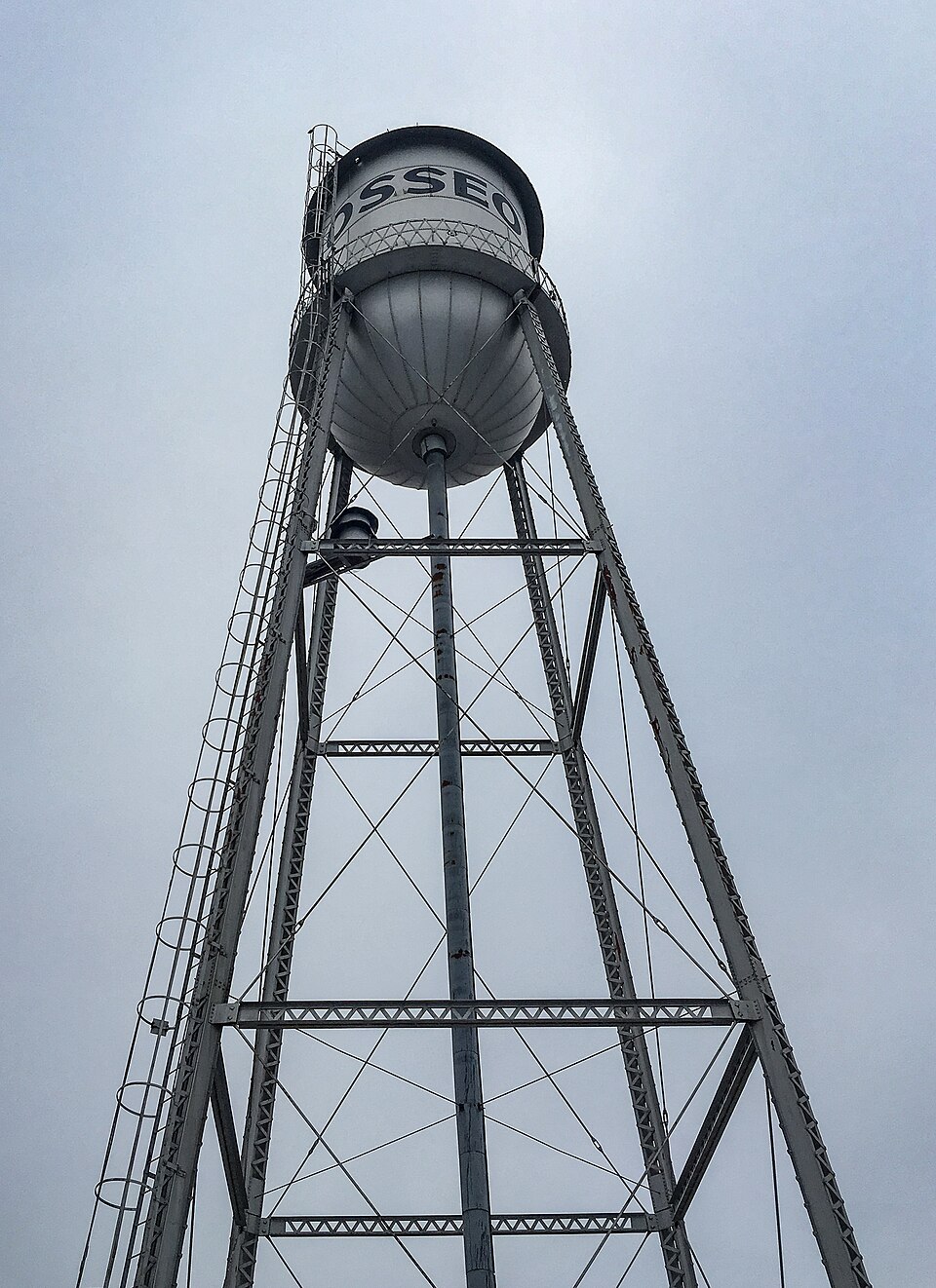
Photograph of Osseo Water Tower
Photograph by Tony Webster from Portland, Oregon, CC BY-SA 2.0. Via Wikimedia Commons.

Osseo Water Tower

Built in 1915. Listed on the National Register of Historic Places in 2017.

From the record

“The Osseo Water Tower in Osseo, Minnesota, is an historic water tower listed in the National Register of Historic Places on June 5, 2017. It was listed for its historical significance to community planning and development in Osseo, because it promoted better fire fighting, provided fresh water to homes and businesses, and supported the growth of the community.”

Wikipedia article Osseo Water Tower, CC BY-SA 4.0.

One of 192 National Register listings published here for Hennepin County · listed in 2017 · category: Structure · built in 1915.

Sources: the Wikipedia article · the National Register database, National Park Service

The listing

  • What is counted as historic. The nomination lists 1 structure as contributing to the listing.
  • Address. 25 4th St., Osseo, 55369
  • When was it listed? June 2017
  • Category. structure
  • City. Osseo city
  • When was it built? 1915
  • National Register reference number. 100001023 - assigned by the National Park Service when the property was listed.

The ground it stands on

38 words

This property stands in Osseo City. History of Hennepin County and the City of Minneapolis, published 1881 gives that township a chapter of its own.

The chapter covers the township.

Machine-read from a century-old scan, so expect the errors a machine makes: misspelled names, dropped words, stray characters.

Read the whole chapter on Osseo City - 38 words on its settlement, mills, schools and churches.

Fires near this property

6 since 1999

Regional context, not property-specific evidence. The federal wildfire occurrence database lists 6 fires within 5 miles of Osseo Water Tower between 1999 and 2012, burning about 101 acres in total. None started naturally. 6 were recorded as arson. Distance is straight-line from the map coordinates, so a fire counted here may appear on a neighbouring settlement's page as well.

Reported cause Fires
Arson/incendiarism6

The most recent of them, most recent first, with the day each was reported and the service that recorded it.

DateCause SizeReported by Name on the report
17 August 2003Arson/incendiarismunder an acreMinnesota Department of Natural Resourcesnot named
3 May 1999Arson/incendiarism3.0 acresMinnesota Department of Natural Resourcesnot named
14 May 2000Arson/incendiarism20 acresMinnesota Department of Natural Resourcesnot named
4 April 2012Arson/incendiarism60 acresMinnesota Department of Natural Resourcesnot named
24 April 2007Arson/incendiarism16 acresMinnesota Department of Natural Resourcesnot named
22 October 2000Arson/incendiarism2.0 acresMinnesota Department of Natural Resourcesnot named

Every fire recorded in Hennepin County

Mines and quarries near this property

10 of 17 shown

Regional context, not property-specific evidence. The federal mineral resources record lists 17 workings within 5 miles of Osseo Water Tower: 16 producers, 1 past producer. 16 still produce. What was taken out: Sand and Gravel, Construction. Distance is straight-line from the map coordinates, so a quarry counted here may appear on a neighbouring settlement's page as well.

Where SiteCommodity StatusRecorded
Anderson No 609 PitSand and Gravel, ConstructionProducer
Barton Pit No 704Sand and Gravel, ConstructionProducer
Barton Pit No 707Sand and Gravel, ConstructionProducer
Barton Pit No 708Sand and Gravel, ConstructionProducer
Barton Pit No 725Sand and Gravel, ConstructionProducer
Barton Pit No 730Sand and Gravel, ConstructionProducer
Chas M Freidheim S&G PitSand and Gravel, ConstructionProducer
Gottchalk Pit No 706Sand and Gravel, ConstructionProducer
Johnson Pit No 724Sand and Gravel, ConstructionProducer
Landers Pit and Mill No 710Sand and Gravel, ConstructionProducer

Every working recorded in Hennepin County

Storms near this property

40 since 2008

Regional context, not property-specific evidence. The National Weather Service names Osseo, the town this property stands in, in 40 storm reports between 2008 and 2024: 16 hail, 13 thunderstorm wind, 5 heavy rain, 3 flash flood. No death or injury is recorded in these reports. Each account below is quoted exactly as the forecast office filed it, from the NOAA Storm Events Database, and each date opens the federal record of that event.

WhenEvent Place namedHarm What the report says
July 2016Thunderstorm WindOsseo$500,000The Maple Grove hospital had structural damage to their building. Pavers from an upper roof blew off and penetrated a roof below. This caused rain to seep into patient rooms and to the 1st floor imaging and PCC. In addition, multiple large trees and large tree limbs were blown down around Maple Grove, with a concentrated area at Berkshire and Dallas Lane. Some trees fell on vehicles.
June 2014LightningOsseo$35,000Lightning struck a home Monday afternoon, June 16th in the 9300 block of Magnolia Lane North, Maple Grove. Lightning struck the attic of the home, caused damage to their roof, and put a 42 hole in the side of their home.
August 2024Thunderstorm WindOsseo-Two birch trees and several tree branches down in Maple Grove.
May 2022Thunderstorm WindOsseo-A gust front resulted in several large tree branches being blown down near the community center in Osseo.
May 2018Thunderstorm WindOsseo-A few trees were reported blown down west of Osseo.
May 2018Thunderstorm WindOsseo-A tree fell on a car near 75th Street and Fernbrook southwest of Osseo.
June 2017Thunderstorm WindOsseo-There was a large 22 inch diameter tree blown down.
September 2016Flash FloodOsseo-Local law enforcement officials closed numerous roads in northern Hennepin county due to flooded roadways. Officials indicated that numerous vehicles stalled and became submerged in the flood waters, especially in the cities of Maple Grove and Brooklyn Park where locally 7 to 10 inches of rain fell in less than 6 hours.
September 2016Heavy RainOsseo-A local trained weather observer measured 7.15 inches of rainfall in Maple Grove, just west of the intersection of Interstates 94, 494, and 694. This was during the afternoon and evening of Wednesday, September 21st.
September 2016Heavy RainOsseo-A local trained weather observer measured 7.20 inches of rainfall in Brooklyn Park (just east of Osseo) between Wednesday afternoon, September 21st, to the early morning of Thursday, September 22nd.
September 2016Heavy RainOsseo-A local trained weather observer measured 9.76 inches of rainfall in Maple Grove (just west of Fish Lake) between Wednesday afternoon, September 21st, to the early morning of Thursday, September 22nd.
September 2016Heavy RainOsseo-A local trained weather observer measured 8.11 inches of rainfall in Maple Grove (on the western edge of Fish Lake) between Wednesday afternoon, September 21st, to the early morning of Thursday, September 22nd.
July 2016Thunderstorm WindOsseo-A MNDOT sensor measured a wind gust along Interstate 94, in Maple Grove.
August 2016Thunderstorm WindOsseo-Several tree branches, up to 5 inches in diameter, were blown down on East Fish Lake Road in Maple Grove. Some siding was also peeled off a shed in the area.
May 2015Thunderstorm WindOsseo-Windows were blown out near Osseo.
June 2015Thunderstorm WindOsseo-Large branches were blown down near Dallas and Berkshire road.
June 2013Flash FloodOsseo-Very heavy rainfall in a short period of time caused flood waters, up to one foot of flowing water, on Vicksburg Lane, from County Road 47, to 72nd Street in Plymouth.
June 2013Thunderstorm WindOsseo-A 28 inch diameter tree was blown down on Timber Crest Drive and Crest Drive North in Maple Grove.
May 2012Heavy RainOsseo-A local observer measured 3.24 inches in the last 24 hours.
July 2011Funnel CloudOsseo-A funnel cloud was reported by the public north of the intersection of Interstate 694 and 494.
June 2010Flash FloodOsseo-Numerous spotters, emergency managers and the general public reported very heavy rainfall in a short period of time that caused significant street flooding across portions of the western and northwestern suburbs of the Twin Cities. Around the Medicine Lake area, and Highway 169, 4 feet of flowing water was reported which stalled numerous cars.
August 2010Thunderstorm WindOsseo-Several trees were blown down near the intersection of Interstate 494 & 694.
May 2008HailOsseo-Hail fell at intersection of I-94 and County road 30.
May 2008HailOsseo-At Interstaste 94 and Hemlock. Chaser also noticed possible significant rear flank downdraft.
May 2008HailOsseo-Occurred at Interstate 94 and County road 30.
May 2008HailOsseo-Hail occurred over Western and Central portions of Maple Grove according to Maple Grove police.
June 2008Thunderstorm WindOsseo-Six to ten inch diameter tree toppled.
June 2008HailOsseo-Hail was observed at the intersection of 63rd and Hwy 169.
May 2008HailOsseo-Hail occurred at I-94 and Hemlock.
August 2019HailOsseo-no account filed
July 2019HailOsseo-no account filed
August 2018HailOsseo-no account filed
July 2016HailOsseo-no account filed
August 2016HailOsseo-no account filed
May 2011Funnel CloudOsseo-no account filed

Every storm recorded in Hennepin County

Map coverage status

No historic map-sheet match is published for this property yet. That does not mean no map exists. This record needs a coordinate-quality review before it can be joined to a sheet boundary. Browse the county's mapped places while that work is pending.

Listed places nearby

2 within 8 miles

Other National Register properties close enough to walk or drive between, ordered by distance from this one. Both positions come from the same geocoding pass that matched these properties to their map sheets.

Photograph PropertyDistance Listed
Graeser Roadside Parking Area6.5 miles2025
Hennepin County Library6.9 miles1978

Sources for this property

National Archives recordThe nomination case file for reference 100001023 in Record Group 79.
Wikipedia articleCommunity-written account of this property, licensed CC BY-SA.
Hennepin CountyAll 192 listed properties in this county.

Provenance

  • Listing record. National Park Service National Register of Historic Places, listed-properties dataset, current to 2026-05-22.
  • Map join. Address geocoded through the United States Census geocoder, then tested against the published boundary of every sheet in the USGS Historical Topographic Map Collection.
  • How this page is made. Listing fields come from federal records; map-sheet coverage is a labelled coordinate-to-boundary calculation, not a source-field claim.
  • Wildfire. Short, Karen C. 2022. Spatial wildfire occurrence data for the United States, 1992-2020 [FPA_FOD_20221014]. 6th Edition. Fort Collins, CO: Forest Service Research Data Archive. https://doi.org/10.2737/RDS-2013-0009.6 Collected with United States Government funding and usable without additional permissions or fees.
  • Mines and quarries. USGS Mineral Resources Data System (MRDS) https://mrdata.usgs.gov/mrds/ A work of the United States government, no copyright under 17 U.S.C. 105.
  • Storms. NOAA National Centers for Environmental Information, Storm Events Database https://www.ncei.noaa.gov/stormevents/ A work of the United States government, no copyright under 17 U.S.C. 105. Narratives are quoted verbatim from the National Weather Service report and are not edited or summarised.