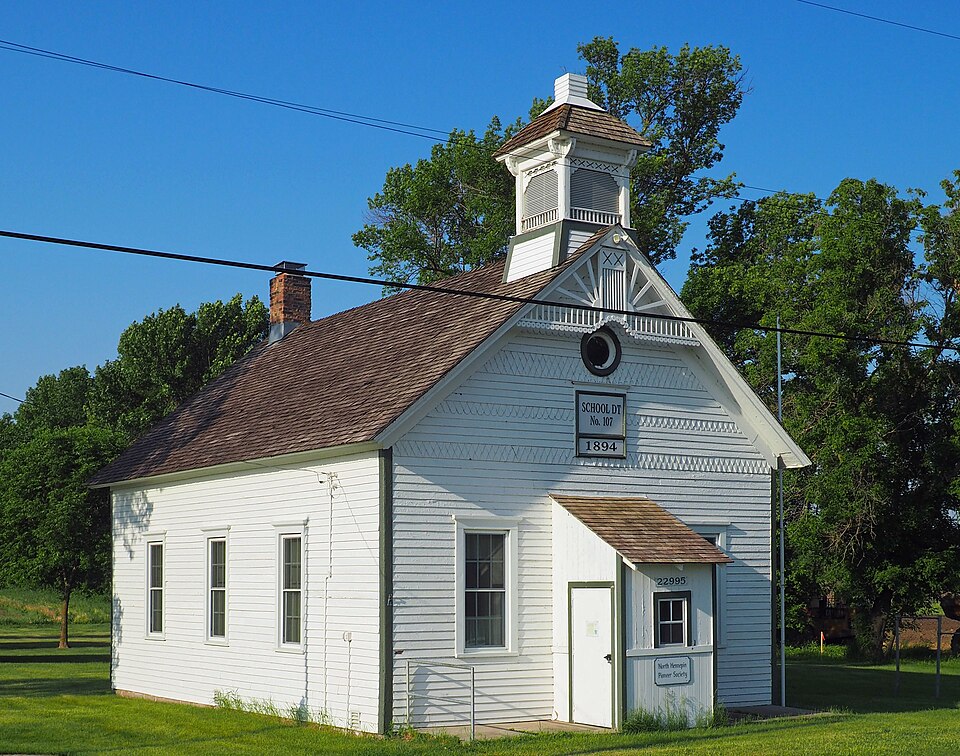
Built in 1894. Listed on the National Register of Historic Places in 2018.
From the record
“Burschville School, also known as District No. 107 School, is a one-room schoolhouse near Corcoran, Minnesota, United States. It was built in 1894 and listed on the National Register of Historic Places in 2018, complete with its original outhouses.”
Wikipedia article Burschville School, CC BY-SA 4.0.
One of 192 National Register listings published here for Hennepin County · listed in 2018 · category: Building · built in 1894.
The township of Corcoran is located in the north-western part of Hennepin county, and is boxmded on the north by Hassan, east by Maple Grove, south by Medina and west by Greenwood. Its surface is rolling, in the south part bluffy. It is heavily timbered with liard and soft maple, oak, elm and basswood. There are occasional patches of wild meadow-land, which produce a good quality of grass. Tlie soil is light in the south part, in the central part it is a heavy l)lack loam, and lighter in the north ]iart. witli a cla\ subsoil throughout. i>roducing wlieat, barley, oats and corn abundantly. Amber cane is grown to some extent. Jubert's Lake, the largest body of w^ater in the the town, is located on sections twenty-nine and thirty-two; there are two other small lakes that are lumamed, one located in the southern part, and the other in the western part of the town. '
Benjamin Pounder, was the first man to enter the unbroken wilderness, and connnenced in lHo-j to lay the foundation <if what is now the flourishing town of Corcoran. He was followed in a few days by P. B. Corcoran, one of the fomiders of the town. lie was accompanied by Morris Eyan, who died in 1878; his family still reside here.
Regional context, not property-specific
evidence. The
federal wildfire occurrence database
lists 7 fires within 5 miles of District No. 107 School
between 2000 and 2013, burning about 26 acres in total. None started naturally. 1 was recorded as arson.
Distance is straight-line from the map coordinates, so a fire counted
here may appear on a neighbouring settlement's page as well.
Reported cause
Fires
Railroad operations and maintenance
3
Debris and open burning
2
Smoking
1
Arson/incendiarism
1
The most recent of
them, most recent first, with the day each was reported and the service
that recorded it.
Regional context, not property-specific
evidence. The federal mineral resources record lists
3 workings within 5 miles of District No. 107 School: 3 producers.
All of them still produce. What was taken out: Sand and Gravel, Construction. Distance is straight-line from the
map coordinates, so a quarry counted here may appear on a neighbouring
settlement's page as well.
Regional context, not property-specific
evidence. The National Weather Service names
Corcoran, the town this property stands in, in 16 storm reports between 1995 and 2023: 6 thunderstorm wind, 4 hail, 2 funnel cloud, 2 heavy rain.
No death or injury is recorded in these reports. Each account below is quoted exactly as the forecast office
filed it, from the NOAA Storm Events Database, and each date
opens the federal record of that event.
A local trained weather observer measured 9.05 inches of rainfall in southwestern Maple Grove between Wednesday afternoon, September 21st, to the early morning of Thursday, September 22nd.
Numerous reports of large hail occurred between Corcoran and Maple Grove, southeast toward Highway 55. The largest hail stone was two inches in diameter.
No historic map-sheet match is published
for this property yet. That does not mean no map exists. This record needs
a coordinate-quality review before it can be joined to a sheet boundary.
Browse the county's mapped places while that work is
pending.
Listed places nearby
2 within 8 miles
Other National Register properties close
enough to walk or drive between, ordered by distance from this one. Both
positions come from the same geocoding pass that matched these properties
to their map sheets.
Listing record. National Park Service National Register of Historic Places, listed-properties dataset, current to 2026-05-22.
Map join. Address geocoded through the United States Census geocoder, then tested against the published boundary of every sheet in the USGS Historical Topographic Map Collection.
How this page is made. Listing fields come from federal records; map-sheet coverage is a labelled coordinate-to-boundary calculation, not a source-field claim.
Wildfire. Short, Karen C. 2022. Spatial wildfire occurrence data for the United States, 1992-2020 [FPA_FOD_20221014]. 6th Edition. Fort Collins, CO: Forest Service Research Data Archive. https://doi.org/10.2737/RDS-2013-0009.6 Collected with United States Government funding and usable without additional permissions or fees.
Mines and quarries. USGS Mineral Resources Data System (MRDS) https://mrdata.usgs.gov/mrds/ A work of the United States government, no copyright under 17 U.S.C. 105.
Storms. NOAA National Centers for Environmental Information, Storm Events Database https://www.ncei.noaa.gov/stormevents/ A work of the United States government, no copyright under 17 U.S.C. 105. Narratives are quoted verbatim from the National Weather Service report and are not edited or summarised.
 Block