 Block
From the record
One of 192 National Register listings published here for Hennepin County · listed in 2021 · category: District.
Sources: the National Register database, National Park Service
Listed on the National Register of Historic Places in 2021.
One of 192 National Register listings published here for Hennepin County · listed in 2021 · category: District.
Sources: the National Register database, National Park Service
The chapter on Excelsior City in History of Hennepin County and the City of Minneapolis, Including the Explorers and Pioneers of Minnesota, published 1881 names Excelsior. This is what it says, exactly as the scans read.
Excelsior was the first point of settlement in the township. Here was located the post-oflice, the first stores, shops, etc., forming tlie nucleus around which the early settlers located their claims and made their homes. The village was
Passage source: History of Hennepin County and the City of Minneapolis, Including the Explorers and Pioneers of Minnesota, published 1881.
The " Excelsior House " was built by George Galpin in 1851, and was at that time of small proportions. The original building is now used as a kitchen for the present hotel. John Green purchased the house and made some additions. The ownership then reverted to Galpin, who sold it to a Mr. Beckford. He managed it about four years, since which time it has been owned by the Wait family. The building has been enlarged from time to time, until it now contains room for 150 guests. It is kept open summer and winter.
Passage source: History of Hennepin County and the City of Minneapolis, Including the Explorers and Pioneers of Minnesota, published 1881.
Machine-read from a century-old scan, so expect the errors a machine makes: misspelled names, dropped words, stray characters.
Read the whole chapter on Excelsior City - 3,589 words on its settlement, mills, schools and churches.
Regional context, not property-specific evidence. The federal wildfire occurrence database lists 1 fire within 5 miles of Excelsior Commercial Historic District in 2004, burning under an acre in total. None started naturally. None was recorded as arson. Distance is straight-line from the map coordinates, so a fire counted here may appear on a neighbouring settlement's page as well.
| Reported cause | Fires |
|---|---|
| Missing data/not specified/undetermined | 1 |
The most recent of them, most recent first, with the day each was reported and the service that recorded it.
| Date | Cause | Size | Reported by | Name on the report |
|---|---|---|---|---|
| 28 April 2004 | Missing data/not specified/undetermined | under an acre | Minnesota Department of Natural Resources | not named |
Regional context, not property-specific evidence. The National Weather Service names Excelsior, the town this property stands in, in 7 storm reports between 2005 and 2020: 4 thunderstorm wind, 3 hail. No death or injury is recorded in these reports. Each account below is quoted exactly as the forecast office filed it, from the NOAA Storm Events Database, and each date opens the federal record of that event.
| When | Event | Place named | Harm | What the report says |
|---|---|---|---|---|
| July 2018 | Thunderstorm Wind | Excelsior | - | A few trees were blown down in Excelsior. |
| July 2015 | Thunderstorm Wind | Excelsior | - | A large tree branch damaged a roof near Christmas Lake in Excelsior. Power was also out in Excelsior. |
| June 2013 | Thunderstorm Wind | Excelsior | - | Measured at the public safety center. |
| June 2005 | Thunderstorm Wind | Excelsior | - | Trees and power lines were damaged. A picnic table was thrown through a picture window. |
| September 2005 | Hail | Excelsior | - | A trained spotter reported nickel to quarter sized hail covering a deck. |
| September 2020 | Hail | Excelsior | - | no account filed |
| June 2007 | Hail | Excelsior | - | no account filed |
No historic map-sheet match is published for this property yet. That does not mean no map exists. This record needs a coordinate-quality review before it can be joined to a sheet boundary. Browse the county's mapped places while that work is pending.
Other National Register properties close enough to walk or drive between, ordered by distance from this one. Both positions come from the same geocoding pass that matched these properties to their map sheets.
| Photograph | Property | Distance | Listed |
|---|---|---|---|
 | Excelsior Public School | 0.1 miles | 1980 |
 | Allemarinda and James Wyer House | 0.2 miles | 1977 |
 | MINNEHAHA (steamboat) | 0.4 miles | 2021 |
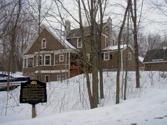 | Peter Gideon Farmhouse | 1.2 miles | 1974 |
| Minnetonka Beach Water Tower | 2.7 miles | 2019 | |
 | Thompson Summer House | 3.0 miles | 1998 |
| National Archives record | The nomination case file for reference 100007070 in Record Group 79. |
| Hennepin County | All 192 listed properties in this county. |