 Block
From the record
One of 27 National Register listings published here for Otter Tail County · listed in 2021 · category: Building.
Sources: the National Register database, National Park Service
Listed on the National Register of Historic Places in 2021.
One of 27 National Register listings published here for Otter Tail County · listed in 2021 · category: Building.
Sources: the National Register database, National Park Service
This property stands in Henning City. Otter Tail County, Minnesota, in the World War;, published 1919 gives that township a chapter of its own.
The chapter covers the township.
Machine-read from a century-old scan, so expect the errors a machine makes: misspelled names, dropped words, stray characters.
Read the whole chapter on Henning City - 23 words on its settlement, mills, schools and churches.
Regional context, not property-specific evidence. The federal wildfire occurrence database lists 11 fires within 5 miles of Lewis House and Medical Office between 1998 and 2012, burning about 108 acres in total. None started naturally. None was recorded as arson. Distance is straight-line from the map coordinates, so a fire counted here may appear on a neighbouring settlement's page as well.
| Reported cause | Fires |
|---|---|
| Debris and open burning | 5 |
| Missing data/not specified/undetermined | 2 |
| Smoking | 1 |
| Other causes | 1 |
| Railroad operations and maintenance | 1 |
| Equipment and vehicle use | 1 |
The most recent of them, most recent first, with the day each was reported and the service that recorded it.
| Date | Cause | Size | Reported by | Name on the report |
|---|---|---|---|---|
| 6 May 2005 | Equipment and vehicle use | 18 acres | Minnesota Department of Natural Resources | not named |
| 4 May 2009 | Debris and open burning | under an acre | Minnesota Department of Natural Resources | not named |
| 7 April 2005 | Debris and open burning | 2.0 acres | Minnesota Department of Natural Resources | not named |
| 18 April 2007 | Railroad operations and maintenance | 32 acres | Minnesota Department of Natural Resources | not named |
| 18 April 2006 | Debris and open burning | 3.0 acres | Minnesota Department of Natural Resources | not named |
| 15 April 2004 | Missing data/not specified/undetermined | 4.1 acres | Minnesota Department of Natural Resources | not named |
| 15 April 1998 | Missing data/not specified/undetermined | under an acre | Minnesota Department of Natural Resources | not named |
| 12 April 2006 | Debris and open burning | 25 acres | Minnesota Department of Natural Resources | not named |
Regional context, not property-specific evidence. The federal mineral resources record lists 1 working within 5 miles of Lewis House and Medical Office: 1 occurrence. None of them still produces. What was taken out: Uranium. Distance is straight-line from the map coordinates, so a quarry counted here may appear on a neighbouring settlement's page as well.
| Where | Site | Commodity | Status | Recorded |
|---|---|---|---|---|
| Uranium Prospect | Uranium | Occurrence |
Regional context, not property-specific evidence. The National Weather Service names Henning, the town this property stands in, in 19 storm reports between 1996 and 2024: 13 hail, 4 thunderstorm wind, 2 tornado. The reports record 1 injury. Each account below is quoted exactly as the forecast office filed it, from the NOAA Storm Events Database, and each date opens the federal record of that event.
| When | Event | Place named | Harm | What the report says |
|---|---|---|---|---|
| October 1996 | Tornado (F2) | Henning | 1 hurt, $400,000 | This tornado followed a track through eastern Otter Tail county, with the first damage report along Highway 210. A man stopped his car along the road when he saw the threatening clouds. The tornado picked his car up and spun it around, with the man inside. The car windows were all broken, but the man only sustained cuts on his hands. The tornado destroyed several farm buildings, one full of dairy cows. 21 of the cows were killed. The last damage report was just west of New York Mills. Two deer hunters were in tree stands when the storm approached. One managed to get down to the ground and lay flat, but the other clung to the tree as the tornado passed. As the wind died down, the man found his tree was the only one left standing in a grove of 36 around him. Neither man was injured. |
| July 2002 | Thunderstorm Wind | Henning | $10,000 | Power poles were blown down by the strong wind. A tree also fell on the city playground equipment, causing a total loss. A new church being constructed was also flattened. |
| July 2024 | Hail | Henning | - | Trained spotter reports half dollar to ping pong ball sized hail. |
| August 2023 | Hail | Henning | - | Off-duty park ranger reported dime to quarter-sized hail east of Henning. Power is out and many trees are down in the area. |
| June 2022 | Hail | Henning | - | Golf ball to baseball sized hail was reported around the Henning area. Photos and reports posted via social media. |
| June 2018 | Thunderstorm Wind | Henning | - | A 10 inch diameter poplar tree was snapped about 8 feet off the ground. |
| September 2017 | Thunderstorm Wind | Henning | - | A few four to six inch diameter tree branches were blown down in groves and shelterbelts across east central Henning Township. |
| August 2011 | Hail | Henning | - | Pea to penny sized hail fell. |
| June 2006 | Tornado (F1) | Henning | - | Numerous 8 to 10 inch tree limbs were snapped or twisted off along the damage path near highway 210. Peak wind speeds were estimated at 80 mph. |
| June 2005 | Thunderstorm Wind | Henning | - | A semi truck and trailer were blown off U.S. Highway 10 and overturned. |
| August 2018 | Hail | Henning | - | no account filed |
| August 2015 | Hail | Henning | - | no account filed |
| July 2008 | Hail | Henning | - | no account filed |
| September 2005 | Hail | Henning | - | no account filed |
| July 2003 | Hail | Henning | - | no account filed |
| April 2003 | Hail | Henning | - | no account filed |
| June 2001 | Hail | Henning | - | no account filed |
| June 2001 | Hail | Henning | - | no account filed |
| July 2000 | Hail | Henning | - | no account filed |
No historic map-sheet match is published for this property yet. That does not mean no map exists. This record needs a coordinate-quality review before it can be joined to a sheet boundary. Browse the county's mapped places while that work is pending.
Other National Register properties close enough to walk or drive between, ordered by distance from this one. Both positions come from the same geocoding pass that matched these properties to their map sheets.
| Photograph | Property | Distance | Listed |
|---|---|---|---|
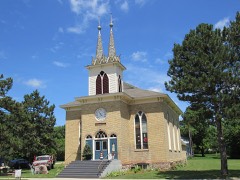 | Trinity Lutheran Church | 0.2 miles | 2018 |
| National Archives record | The nomination case file for reference 100007309 in Record Group 79. |
| Otter Tail County | All 27 listed properties in this county. |