 Block
From the record
One of 60 National Register listings published here for Goodhue County · listed in 2014 · category: Building.
Sources: the National Register database, National Park Service
Listed on the National Register of Historic Places in 2014.
One of 60 National Register listings published here for Goodhue County · listed in 2014 · category: Building.
Sources: the National Register database, National Park Service
The chapter on Pine Island City in History of Goodhue County, Including a Sketch of the Territory and State of Minnesota; Together with an Account of the Early French Discoveries, Indian Massacres, the Part Borne by Minnesota's Patriots in the War of the Great Rebellion, and a Full and Complete History of the County from the Time of Its Occupancy by Swiss Missionaries in 1838. Pioneer Incidents, Biographical Sketches of Early and Prominent Settlers and Representative Men, and of Its Cities, Towns, Churches, Schools, Secret Societies, Etc, published 1878 names Pine Island. This is what it says, exactly as the scans read.
This paper was established August 30, 1878, by the "Pine Island News Company." A. M. Hutchinson, editor, It is a newsy sheet, well edited and popular for the time it has been in existence. The paper is an eight column folio sheet, typographically neat, and it is well filled with local and general information. It starts off with a liberal advertising patronage ; is issued on Friday of each week.
The first settlement was made in Roscoe in 1854 by James Haggard and W. Wilson, both locating claims in section 5. Wilson subsequently returned to his home in the East, but Haggard remained until his shanty was burned, when he returned to Brown county where he still resides. Fletcher Hagler numbers among those of the earliest pioneers of the town, having selected his claim in 1855 on the site of ground where the village of Roscoe now stands, and where he erected the first frame house in this township. He was also the first postmaster appointed, and from this pioneer record removed to Pine Island, where he was enrolled among the number of early pilgrims in that township.
Machine-read from a century-old scan, so expect the errors a machine makes: misspelled names, dropped words, stray characters.
Read the whole chapter on Pine Island City - 4,149 words on its settlement, mills, schools and churches.
Regional context, not property-specific evidence. The federal wildfire occurrence database lists 1 fire within 5 miles of Bringgold, Jacob A. and Mary Finn House in 2016, burning under an acre in total. None started naturally. None was recorded as arson. Distance is straight-line from the map coordinates, so a fire counted here may appear on a neighbouring settlement's page as well.
| Reported cause | Fires |
|---|---|
| Missing data/not specified/undetermined | 1 |
The most recent of them, most recent first, with the day each was reported and the service that recorded it.
| Date | Cause | Size | Reported by | Name on the report |
|---|---|---|---|---|
| 15 November 2016 | Missing data/not specified/undetermined | under an acre | Minnesota Department of Natural Resources | not named |
Regional context, not property-specific evidence. The federal mineral resources record lists 1 working within 5 miles of Bringgold, Jacob A. and Mary Finn House: 1 producer. All of them still produce. What was taken out: Stone, Crushed/Broken. Distance is straight-line from the map coordinates, so a quarry counted here may appear on a neighbouring settlement's page as well.
| Where | Site | Commodity | Status | Recorded |
|---|---|---|---|---|
| Roscoe Quarry | Stone, Crushed/Broken | Producer |
Regional context, not property-specific evidence. The National Weather Service names Pine Island, the town this property stands in, in 1 storm report in 1996: 1 thunderstorm wind. No death or injury is recorded in these reports. Each account below is quoted exactly as the forecast office filed it, from the NOAA Storm Events Database, and each date opens the federal record of that event.
| When | Event | Place named | Harm | What the report says |
|---|---|---|---|---|
| May 1996 | Thunderstorm Wind | Pine Island | - | no account filed |
No historic map-sheet match is published for this property yet. That does not mean no map exists. This record needs a coordinate-quality review before it can be joined to a sheet boundary. Browse the county's mapped places while that work is pending.
Other National Register properties close enough to walk or drive between, ordered by distance from this one. Both positions come from the same geocoding pass that matched these properties to their map sheets.
| Photograph | Property | Distance | Listed |
|---|---|---|---|
| Jacob Bringghold House | under 500 feet | 1980 | |
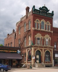 | Opera Block House | 0.2 miles | 1980 |
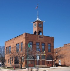 | Pine Island City Hall and Fire Station | 0.2 miles | 1980 |
| George Baslington Farmhouse | 3.8 miles | 1980 | |
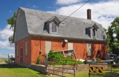 | Roscoe Butter and Cheese Factory | 6.1 miles | 1980 |
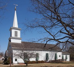 | First Congregational Church of Zumbrota | 6.3 miles | 1980 |
| National Archives record | The nomination case file for reference 14000216 in Record Group 79. |
| Goodhue County | All 60 listed properties in this county. |