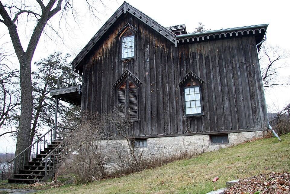
Listed on the National Register of Historic Places in 1973.
From the record
“The Willard Bunnell House is a historic house museum in Homer, Minnesota, United States. The house was listed on the National Register of Historic Places in 1973 for having state-level significance in the themes of architecture, commerce, and exploration/settlement.”
Wikipedia article Willard Bunnell House, CC BY-SA 4.0.
One of 50 National Register listings published here for Winona County · listed in 1973 · category: Building.
National Register reference number.73000998- the number the National Park Service assigned this property when it was listed, and the key its nomination file is catalogued under at the National Archives.
The ground it stands on
3,708 words
The chapter on Homer Township in History of Winona County, published 1883 names Winona. This is what it says, exactly as the scans read.
Homer township was organized May 11, 1858. It lies in T. 106 and 107 W. and R. 6 IST. It is bounded on the west b}' Wilson and Winona townships, on the south by Pleasant Hill township, on the east by Richmond township, and on the north by the Mississippi river. It comprises thirty-three complete sections and five fractional ones. The Mississippi river strikes the township on N, W. J of Sec. 31, and flows southeast through Sees. 1, 2 and 3. The surface is very much broken ; the soil on the ridge land is clay, while in the valleys it is a black loam. The products are wheat, corn, oats and barley. The average per acre for the present year (1882) is as follows : Wheat, per acre, 12 bushels ; corn, per acre, 60 bushels ; oats, per acre, 35 bushels. Stone quarries may be found all along the river, but they are only worked occasionally.
Pleasant Hill township, commonly described as No. 105 N., R. 6 W,, contains thirty-six full sections of 640 acres each. It is situated on the ridge between the Mississippi and Root rivers. The old territorial road between La Crosse, Wisconsin, and Mankato, Minnesota, runs upon this ridge, entering the township at tlie southeast corner of section 36 ; thence pursuing a winding diagonal course it leaves the township about eighty rods south of the north line of section 7. The northeastern part of the township is drained by Trout creek, the northwestern part by bi-anches of Cedar creek ; both of these streams flow into the Mississippi river. The western part is drained by three branches of Money creek. The principal one is called Corey Valley creek, in honor of H. A. Corey, who settled just over the line in the edge ot Wiscoy township. The southwestern and southern portions are drained by branches of Silver creek. The principal one of these streams is called Loony Valley Run. These streams flow into Root river. The eastern part is drained by the branches of Pine creek, known as north branch and south branch. They unite about one hundred rods east of Pleasant Hill township, at New Hartford postoffice, and flow into the Mississippi river. This tovmship was named by Joseph Cooper, wIk^ came here in December, 1854, and made a chiim. Some time in the springy of 1856 Mr. Cooper made application to the postoffice department at Washington for a postoffice, to be called Pleasant Hill. While awaitino; the return from Washing:- ton, he and others organized a school district, and when asked by the county registrar of deeds at Winona for the name of the township, he turned to a neighbor, Mr. Reynolds, and asked what they should call the town. Mr. Reynolds said, "Call it the same as the postoffice." So he told the recorder it was Pleasant Hill.
Regional context, not property-specific
evidence. The
federal wildfire occurrence database
lists 34 fires within 5 miles of Willard Bunnell House
between 1993 and 2020, burning about 107 acres in total. 2 started naturally. 3 were recorded as arson.
Distance is straight-line from the map coordinates, so a fire counted
here may appear on a neighbouring settlement's page as well.
Reported cause
Fires
Debris and open burning
16
Missing data/not specified/undetermined
6
Arson/incendiarism
3
Recreation and ceremony
3
Natural
2
Railroad operations and maintenance
2
Equipment and vehicle use
1
Smoking
1
The most recent of
them, most recent first, with the day each was reported and the service
that recorded it.
Regional context, not property-specific
evidence. The federal mineral resources record lists
12 workings within 5 miles of Willard Bunnell House: 8 past producers, 3 occurrences, 1 producer.
1 still produces. What was taken out: Sand and Gravel, Construction, Stone, Crushed/Broken. Distance is straight-line from the
map coordinates, so a quarry counted here may appear on a neighbouring
settlement's page as well.
Regional context, not property-specific
evidence. The National Weather Service names
Winona, the town this property stands in, in 141 storm reports between 1993 and 2025: 55 hail, 42 thunderstorm wind, 25 flood, 7 heavy rain.
No death or injury is recorded in these reports. Each account below is quoted exactly as the forecast office
filed it, from the NOAA Storm Events Database, and each date
opens the federal record of that event.
All drainage areas leading into communities in eastern Winona County experienced tremendous flash flooding. State Highway 43 was washed out just south of Winona. In addition, more than 300 residents were evacuated from their homes in Goodview due to high water. In Minnesota City a railroad bridge was ripped apart by Garvin Brook and a highway bridge through town suffered major damage on each end. Railroad tracks were warped or pushed clear out of position. Major erosion was seen.
Law enforcement officials reported some roads and bridges washed out or still under water. Whitewater State Park remained closed. In Goodview, extensive damage occurred to homes and apartments due to flood waters. All or portions of highways still closed included Highway 76 from Interstate 90 to Highway 16.
A short-lived tornado moved through Woodlawn Cemetery in Winona. The tornado caused extensive damage to trees and gravestones. The roof of a shed was also damaged.
Significant rainfall throughout June pushed the Mississippi River at Winona into flood stage in June and continued into July. The river stage crested during the afternoon on July 2nd in moderate flood stage at 16.14 ft.
Runoff from heavy rain caused mudslides to occur south of Pickwick. The mudslide took down trees and covered County Road 7 between Pickwick and County Road 12. County Road 7 was also covered by floodwaters from Big Trout Creek. A rockslide occurred on Garvin Heights Road in the city of Winona.
Runoff after a couple of rainfall events pushed the Mississippi River out of its banks again in Winona. The river crested over two feet above the flood stage at 15.13 feet on May 25th. The flooding continued into June.
A lightning strike produced a 2 square foot hole in the roof of a detached garage. The resulting fire was quickly put out with no other damage occurring to the garage.
No historic map-sheet match is published
for this property yet. That does not mean no map exists. This record needs
a coordinate-quality review before it can be joined to a sheet boundary.
Browse the county's mapped places while that work is
pending.
Listed places nearby
6 within 8 miles
Other National Register properties close
enough to walk or drive between, ordered by distance from this one. Both
positions come from the same geocoding pass that matched these properties
to their map sheets.
Listing record. National Park Service National Register of Historic Places, listed-properties dataset, current to 2026-05-22.
Map join. Address geocoded through the United States Census geocoder, then tested against the published boundary of every sheet in the USGS Historical Topographic Map Collection.
How this page is made. Listing fields come from federal records; map-sheet coverage is a labelled coordinate-to-boundary calculation, not a source-field claim.
Wildfire. Short, Karen C. 2022. Spatial wildfire occurrence data for the United States, 1992-2020 [FPA_FOD_20221014]. 6th Edition. Fort Collins, CO: Forest Service Research Data Archive. https://doi.org/10.2737/RDS-2013-0009.6 Collected with United States Government funding and usable without additional permissions or fees.
Mines and quarries. USGS Mineral Resources Data System (MRDS) https://mrdata.usgs.gov/mrds/ A work of the United States government, no copyright under 17 U.S.C. 105.
Storms. NOAA National Centers for Environmental Information, Storm Events Database https://www.ncei.noaa.gov/stormevents/ A work of the United States government, no copyright under 17 U.S.C. 105. Narratives are quoted verbatim from the National Weather Service report and are not edited or summarised.
 Block