BlockBefore
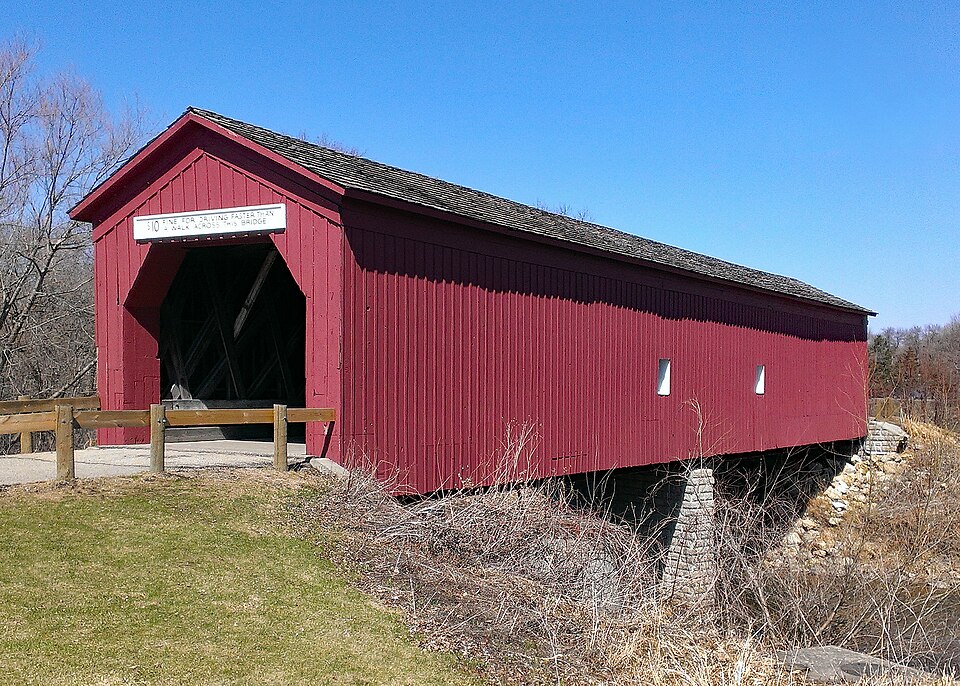
Photograph of Zumbrota Covered Bridge
Photograph by McGhiever, CC BY-SA 4.0. Via Wikimedia Commons.

Zumbrota Covered Bridge

Built in 1869. Listed on the National Register of Historic Places in 1975.

From the record

One of 60 National Register listings published here for Goodhue County · listed in 1975 · category: Structure · built in 1869.

Sources: the case file at the National Archives · the National Register database, National Park Service · the Wikipedia article

The listing

  • What is counted as historic. The nomination lists 1 structure as contributing to the listing.
  • Address. West Ave over the North Fork of the Zumbro River, Zumbrota, 55992
  • When was it listed? February 1975
  • Category. structure
  • Also known as. Rural Goodhue County MRA (AD); Rural Goodhue County MRA
  • City. Zumbrota city
  • When was it built? 1869
  • National Register reference number. 75000984 - the number the National Park Service assigned this property when it was listed, and the key its nomination file is catalogued under at the National Archives.

The ground it stands on

9,568 words

The chapter on Zumbrota Township in History of Goodhue County, Including a Sketch of the Territory and State of Minnesota; Together with an Account of the Early French Discoveries, Indian Massacres, the Part Borne by Minnesota's Patriots in the War of the Great Rebellion, and a Full and Complete History of the County from the Time of Its Occupancy by Swiss Missionaries in 1838. Pioneer Incidents, Biographical Sketches of Early and Prominent Settlers and Representative Men, and of Its Cities, Towns, Churches, Schools, Secret Societies, Etc, published 1878 names Zumbrota. This is what it says, exactly as the scans read.

Aaron Doty entered the northwest quarter and the southwest quarter of section 31, in 1856. The village was platted on this land by the Strafford Emigration Company, in September, 1856. Bailey and Thompson made an addition, which is called North Zumbrota in 1857. The west addition was made by Josiah Thompson, on section 36, Minneola township. The first house was built by C. W. Smith. It was a log structure, 14x18, and built on the south bank of the Zumbrota

Passage source: History of Goodhue County, Including a Sketch of the Territory and State of Minnesota; Together with an Account of the Early French Discoveries, Indian Massacres, the Part Borne by Minnesota's Patriots in the War of the Great Rebellion, and a Full and Complete History of the County from the Time of Its Occupancy by Swiss Missionaries in 1838. Pioneer Incidents, Biographical Sketches of Early and Prominent Settlers and Representative Men, and of Its Cities, Towns, Churches, Schools, Secret Societies, Etc, published 1878.

The "Zumbrota Independent," was established March 25, 1875, by E. A. Mitchell, the present editor and proprietor. In the beginning, it was a six column to the page folio sheet, then seven columns, eight columns, and it now speaks to the people a quarto sheet of forty columns. It is independent in politics, devoted to the interests of Goodhue county in general, and Zumbrota in particular. It has labored faithfully in behalf of the railroad interests of that section, enjoys a good circulation and is liberally supported.

Passage source: History of Goodhue County, Including a Sketch of the Territory and State of Minnesota; Together with an Account of the Early French Discoveries, Indian Massacres, the Part Borne by Minnesota's Patriots in the War of the Great Rebellion, and a Full and Complete History of the County from the Time of Its Occupancy by Swiss Missionaries in 1838. Pioneer Incidents, Biographical Sketches of Early and Prominent Settlers and Representative Men, and of Its Cities, Towns, Churches, Schools, Secret Societies, Etc, published 1878.

Machine-read from a century-old scan, so expect the errors a machine makes: misspelled names, dropped words, stray characters.

Read the whole chapter on Zumbrota Township - 9,568 words on its settlement, mills, schools and churches.

Fires near this property

12 since 2003

Regional context, not property-specific evidence. The federal wildfire occurrence database lists 12 fires within 5 miles of Zumbrota Covered Bridge between 2003 and 2020, burning about 69 acres in total. None started naturally. None was recorded as arson. Distance is straight-line from the map coordinates, so a fire counted here may appear on a neighbouring settlement's page as well.

Reported cause Fires
Missing data/not specified/undetermined10
Debris and open burning1
Fireworks1

The most recent of them, most recent first, with the day each was reported and the service that recorded it.

DateCause SizeReported by Name on the report
27 August 2003Missing data/not specified/undeterminedunder an acreMinnesota Department of Natural Resourcesnot named
14 August 2003Missing data/not specified/undetermined1.0 acresMinnesota Department of Natural Resourcesnot named
13 July 2019Missing data/not specified/undeterminedunder an acreMinnesota Department of Natural Resourcesnot named
6 May 2020Missing data/not specified/undetermined55 acresMinnesota Department of Natural Resourcesnot named
29 April 2015Missing data/not specified/undeterminedunder an acreMinnesota Department of Natural Resourcesnot named
12 December 2020Fireworksunder an acreMinnesota Department of Natural Resourcesnot named
5 November 2019Missing data/not specified/undeterminedunder an acreMinnesota Department of Natural Resourcesnot named
15 November 2016Missing data/not specified/undeterminedunder an acreMinnesota Department of Natural Resourcesnot named

Every fire recorded in Goodhue County

Mines and quarries near this property

4 within 5 miles

Regional context, not property-specific evidence. The federal mineral resources record lists 4 workings within 5 miles of Zumbrota Covered Bridge: 4 producers. All of them still produce. What was taken out: Stone, Crushed/Broken, Sand and Gravel, Construction. Distance is straight-line from the map coordinates, so a quarry counted here may appear on a neighbouring settlement's page as well.

Where SiteCommodity StatusRecorded
Deden QuarryStone, Crushed/BrokenProducer
Dierke Pit & MillSand and Gravel, ConstructionProducer
Kyllo QuarryStone, Crushed/BrokenProducer
Lokens Pit & MillSand and Gravel, ConstructionProducer

Every working recorded in Goodhue County

Storms near this property

32 since 1996

Regional context, not property-specific evidence. The National Weather Service names Zumbrota, the town this property stands in, in 32 storm reports between 1996 and 2025: 15 hail, 11 thunderstorm wind, 3 tornado, 1 flash flood. No death or injury is recorded in these reports. Each account below is quoted exactly as the forecast office filed it, from the NOAA Storm Events Database, and each date opens the federal record of that event.

WhenEvent Place namedHarm What the report says
September 2018Tornado (EF0)Zumbrota$50,000A NWS storm survey, plus areal footage of drone and satellite data, concluded that an EF0 tornado started north of Zumbrota, and tracked northeast for 5.4 miles until moving into Wabasha County, southwest of Bellechester. This tornado tracked mainly through corn and soy bean fields, and occasionally damaging a few sheds and outbuildings. The damage was consistent with EF0 damage with maximum wind speeds of 85 mph and a width of 150 yards.
March 2025HailZumbrota-Multiple reports of large hail, up to 1.25 inches in diameter. Sources include a trained weather spotter in Zumbrota and a Broadcast Meteorologist.
July 2025Thunderstorm WindZumbrota-Large tree branch down in Zumbrota MN.
September 2019Thunderstorm WindZumbrota-Several trees and power lines were blown down around Zumbrota.
July 2019Thunderstorm WindZumbrota-There was a large tree that was uprooted in the city of Zumbrota.
July 2016Thunderstorm WindZumbrota-Multiple trees were blown down near Zumbrota.
July 2011Thunderstorm WindZumbrota-Several large tree limbs were blown off near Zumbrota, Minnesota.
August 2010Heavy RainZumbrota-A local observer measured 2.72 inches of rainfall in three hours.
July 2006Thunderstorm WindZumbrota-Scattered trees down.
March 2005HailZumbrota-Golf ball hail fell along Highway 52.
March 2005Funnel CloudZumbrota-Observed nearly over town.
May 2004Tornado (F0)Zumbrota-A tornado briefly touched down just west of Mazeppa. A few trees were downed and a fence was damaged before the tornado dissipated.
July 2004Thunderstorm WindZumbrota-A 1 foot diameter tree was downed onto 5th Street.
July 2002Thunderstorm WindZumbrota-Few trees down.
May 1998Thunderstorm WindZumbrota-Trees down. Estimated windspeed.
July 1997Thunderstorm WindZumbrota-Large tree blown over. Estimated windspeed.
May 2024HailZumbrota-no account filed
September 2016HailZumbrota-no account filed
May 2012HailZumbrota-no account filed
August 2012HailZumbrota-no account filed
May 2011HailZumbrota-no account filed
September 2007HailZumbrota-no account filed
July 2006HailZumbrota-no account filed
August 2006HailZumbrota-no account filed
May 2004HailZumbrota-no account filed
June 1998Tornado (F0)Zumbrota-no account filed
June 1998HailZumbrota-no account filed
July 1997Flash FloodZumbrota-no account filed
May 1996Thunderstorm WindZumbrota-no account filed

Every storm recorded in Goodhue County

Map coverage status

No historic map-sheet match is published for this property yet. That does not mean no map exists. This record needs a coordinate-quality review before it can be joined to a sheet boundary. Browse the county's mapped places while that work is pending.

Listed places nearby

6 within 8 miles

Other National Register properties close enough to walk or drive between, ordered by distance from this one. Both positions come from the same geocoding pass that matched these properties to their map sheets.

Sources for this property

National Archives recordThe nomination case file for reference 75000984 in Record Group 79.
Wikipedia articleCommunity-written account of this property, licensed CC BY-SA.
Goodhue CountyAll 60 listed properties in this county.

Provenance

  • Listing record. National Park Service National Register of Historic Places, listed-properties dataset, current to 2026-05-22.
  • Map join. Address geocoded through the United States Census geocoder, then tested against the published boundary of every sheet in the USGS Historical Topographic Map Collection.
  • How this page is made. Listing fields come from federal records; map-sheet coverage is a labelled coordinate-to-boundary calculation, not a source-field claim.
  • Wildfire. Short, Karen C. 2022. Spatial wildfire occurrence data for the United States, 1992-2020 [FPA_FOD_20221014]. 6th Edition. Fort Collins, CO: Forest Service Research Data Archive. https://doi.org/10.2737/RDS-2013-0009.6 Collected with United States Government funding and usable without additional permissions or fees.
  • Mines and quarries. USGS Mineral Resources Data System (MRDS) https://mrdata.usgs.gov/mrds/ A work of the United States government, no copyright under 17 U.S.C. 105.
  • Storms. NOAA National Centers for Environmental Information, Storm Events Database https://www.ncei.noaa.gov/stormevents/ A work of the United States government, no copyright under 17 U.S.C. 105. Narratives are quoted verbatim from the National Weather Service report and are not edited or summarised.