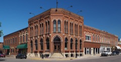
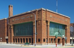
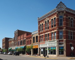
Listed on the National Register of Historic Places in 1975.
From the record
“The Latsch Building is a historic commercial property in Winona, Minnesota, United States. Once known as the Kupietz Block, it was constructed in stages from 1860 to the 1880s.”
Wikipedia article Latsch Building, CC BY-SA 4.0.
One of 50 National Register listings published here for Winona County · listed in 1975 · category: Building.
National Register reference number.75001036- the number the National Park Service assigned this property when it was listed, and the key its nomination file is catalogued under at the National Archives.
The ground it stands on
29,591 words
The chapter on Winona City in History of Winona County, published 1883 names Winona. This is what it says, exactly as the scans read.
The last two or three years' compilation included the entire grain shipments over the Winona & St. Peter railroad, and as it was almost impossible longer to keep the run of the actual shipments from first hands, the compilation was discontinued. In 1868, when the grain shipments reached as per above table, the amount of 2,432,080 bushels, Winona rated as the fourth primary grain market in the Tnited States, Chicago, Milwaukee and Toledo alone leading her in this respect. No pains were spared to center this immense grain trade at this distributing point, and this intelligent effort was crowned with such success that it soon raised Winona to the very front rank of Minnesota cities, and gave her an impetus in the way of progress that has tided her over the shoals of two seasons ol financial depression into the haven of assured prosperity. During the ten days ended July 24, 1875, the shipments of wheat from Winona were 100,000 bushels. Until railway communication was established with the eastern markets, tliat is, for about twelve years from the opening up of the export trade in wheat at this point, all shipments were by river, and the scene along the Winona levee during the months that navigation was open was indeed a busy one. This new industry came most opportunely to Winona, at a time when she was just recovering from the financial depressi(m of 1857-8, and under its impulse and the returning prosperity her population almost doubled in the five years from 1860 to 1865, notwithstanding the nation was involved in bitter and protracted civil war during almost that entire period. During the next five years she more than doubled her population, and was conceded without question the third place in importance and population in Minnesota. As was natural, the growth of the little settlement on Wabasha prairie began along the front of the great river whose current, unused for ages by larger craft than the canoe of the aborigines, had of late years felt the ploughing keels of mightier craft, and borne the burdens of a growing commerce. The dedication of the original plat, among other reservations, for public use and pleasure, stipulated for a levee stretching along the sandy, gravelly margin of the river for about 2,000 feet, from" Walnut street on the east to Washington street on the west, and running back from the river to Front street. The foot of Center street touched this public levee as nearly as possible in the center, as its name indicates. Fronting this levee, almost at its eastern extremity, the cabins of the pioneers and the shanties of the first merchants were clustered in the early days of 1852-3. Later, the warehouses of the grain-dealers clustered around the outskirts of the levee, and the whole face of trade was turned toward the Father of Watei-s, whose broad tide floated the commercial ventures of the growing metropolis of southwestern Minnesota.
When the great fire of 1862 swept clean the business of the place, and so many presaged the death of the young city, it was in fact but the clearing away of the old wooden structures, that upon their unsightly ruins might be laid the substantial foundations of tlie solid blocks of brick and mortal- that have risen in their place. This work of building has kept pace with the growing prosperity of the city, until to-day whole blocks of solid brick stretch along the main business thoroughfares of the city, and give an air of substantialness and permanency to the trade of the city, thoroughly in keeping with the confidence, everywhere felt by her capital and trade, that this permanency is real. The residence portion of the city is also most creditable to the taste of the citizens, and evidences the pride they feel in the city they have built. Elegant dwellings, spacious grounds, velvet lawns, charming beds of color in flower and foliage are found all along the principal residence streets; and outside these grounds the ornamentation is continued in broad borders of greensward, extending from the sidewalks toward the center of the street from ten to twelve feet, and rising above the driveway from ten to twelve inches. The sod on these borders is kept as closely shaven and well watered as the lawns, and the whole eft'ect most grateful and cooling to the senses as one walks or drives along the thoroughfare in the delicious fragrance of an early summer evening. The public buildings (with the single exception of the court-house, which time will some day remedy) are a credit to the city. The state normal school, erected at a cost of $165,000, occupies two full blocks in a charming situation, well back from the river, and its grounds are most delightfully laid out, unfenced, and always kept green and fresh during the growing season. The high school building and the ward scliools each occupy a full block, and the spacious grounds are kept in most excellent condition. The ample roominess ot these grounds, and the provision made for the comfort of the children, as well on the play-grounds as within the sclioolrooms, are a noticeable feature of the Winona public schools. As in her schools, so in her churches Winona has taken a most commendable pride. The (,'atholics, Episcopalians. Congregationalists, Presbyterians and Methodists have all that could be required in this direction. The Episcopal and Congregational churches are built of solid stone, and the latter of these structures, erected in 1882, is really a poem in stone, an architectural gem in granite. The bend in the river at this point has placed Winona within a ]K)cket in the bluffs, and looking out in any direction your eye rests on the surrounding heights, rising above the spires of the city and overlooking every object of interest. Across Winona lake lies Wof)dlawn cemetery, that beautiful city of the silent, than which no more quiet resting-place, in which to sleep after life's fitful fever is over, can well be found. It lies just within a little upland vale, and encroaching very perceptibly upon the rugged steeps that inclose the little valley on the west. Here the ground has been terraced and sodded, and broken into irregular forms, and in all things made to preserve its character as the dear resting-place for the weary when the di-eamless sleep into which life sooner or later quiets itself shall come. The morning beams salute the faces of the terraces as the sun climbs the eastern sky and peers over the bluff in the orient. The midday sun warms the cool shadiness and penetrates each leafy nook and green retreat, the westering sun retires behind the height up which the terraced mounds are built, and his long shadows fall like the hovering wings of peace, regretful to depart, over the beautiful resting-place of Winona's dreamless sleepers. Turning from the quiet of Woodlawn to the bustling activities of the city, witliout more particularly noting the stages of her growth, her magnificent system of water-works, or aught else connected with her public spirit or private ways, leaving unsaid all so easily inferred, the growing wealth of her citizens, the superior character of her j)ublic schools, tiie intelligence of her people, the social culture of her homes, the health fulness of her atmosphere, the beauty of her surroundings, and the charming views of natural scenery alternating in wood and water colors ; we close this article
Regional context, not property-specific
evidence. The
federal wildfire occurrence database
lists 30 fires within 5 miles of Kirch/Latch Building
between 1993 and 2019, burning about 93 acres in total. 1 started naturally. 3 were recorded as arson.
Distance is straight-line from the map coordinates, so a fire counted
here may appear on a neighbouring settlement's page as well.
Reported cause
Fires
Debris and open burning
15
Smoking
4
Arson/incendiarism
3
Missing data/not specified/undetermined
3
Recreation and ceremony
2
Railroad operations and maintenance
1
Equipment and vehicle use
1
Natural
1
The most recent of
them, most recent first, with the day each was reported and the service
that recorded it.
Regional context, not property-specific
evidence. The federal mineral resources record lists
21 workings within 5 miles of Kirch/Latch Building: 11 occurrences, 5 producers, 5 past producers.
5 still produce. What was taken out: Stone, Crushed/Broken, Sand and Gravel, Construction, Limestone, Dimension. Distance is straight-line from the
map coordinates, so a quarry counted here may appear on a neighbouring
settlement's page as well.
Regional context, not property-specific
evidence. The National Weather Service names
Winona, the town this property stands in, in 141 storm reports between 1993 and 2025: 55 hail, 42 thunderstorm wind, 25 flood, 7 heavy rain.
No death or injury is recorded in these reports. Each account below is quoted exactly as the forecast office
filed it, from the NOAA Storm Events Database, and each date
opens the federal record of that event.
All drainage areas leading into communities in eastern Winona County experienced tremendous flash flooding. State Highway 43 was washed out just south of Winona. In addition, more than 300 residents were evacuated from their homes in Goodview due to high water. In Minnesota City a railroad bridge was ripped apart by Garvin Brook and a highway bridge through town suffered major damage on each end. Railroad tracks were warped or pushed clear out of position. Major erosion was seen.
Law enforcement officials reported some roads and bridges washed out or still under water. Whitewater State Park remained closed. In Goodview, extensive damage occurred to homes and apartments due to flood waters. All or portions of highways still closed included Highway 76 from Interstate 90 to Highway 16.
A short-lived tornado moved through Woodlawn Cemetery in Winona. The tornado caused extensive damage to trees and gravestones. The roof of a shed was also damaged.
Significant rainfall throughout June pushed the Mississippi River at Winona into flood stage in June and continued into July. The river stage crested during the afternoon on July 2nd in moderate flood stage at 16.14 ft.
Runoff from heavy rain caused mudslides to occur south of Pickwick. The mudslide took down trees and covered County Road 7 between Pickwick and County Road 12. County Road 7 was also covered by floodwaters from Big Trout Creek. A rockslide occurred on Garvin Heights Road in the city of Winona.
Runoff after a couple of rainfall events pushed the Mississippi River out of its banks again in Winona. The river crested over two feet above the flood stage at 15.13 feet on May 25th. The flooding continued into June.
A lightning strike produced a 2 square foot hole in the roof of a detached garage. The resulting fire was quickly put out with no other damage occurring to the garage.
No historic map-sheet match is published
for this property yet. That does not mean no map exists. This record needs
a coordinate-quality review before it can be joined to a sheet boundary.
Browse the county's mapped places while that work is
pending.
Listed places nearby
6 within 8 miles
Other National Register properties close
enough to walk or drive between, ordered by distance from this one. Both
positions come from the same geocoding pass that matched these properties
to their map sheets.
Listing record. National Park Service National Register of Historic Places, listed-properties dataset, current to 2026-05-22.
Map join. Address geocoded through the United States Census geocoder, then tested against the published boundary of every sheet in the USGS Historical Topographic Map Collection.
How this page is made. Listing fields come from federal records; map-sheet coverage is a labelled coordinate-to-boundary calculation, not a source-field claim.
Wildfire. Short, Karen C. 2022. Spatial wildfire occurrence data for the United States, 1992-2020 [FPA_FOD_20221014]. 6th Edition. Fort Collins, CO: Forest Service Research Data Archive. https://doi.org/10.2737/RDS-2013-0009.6 Collected with United States Government funding and usable without additional permissions or fees.
Mines and quarries. USGS Mineral Resources Data System (MRDS) https://mrdata.usgs.gov/mrds/ A work of the United States government, no copyright under 17 U.S.C. 105.
Storms. NOAA National Centers for Environmental Information, Storm Events Database https://www.ncei.noaa.gov/stormevents/ A work of the United States government, no copyright under 17 U.S.C. 105. Narratives are quoted verbatim from the National Weather Service report and are not edited or summarised.
 Block