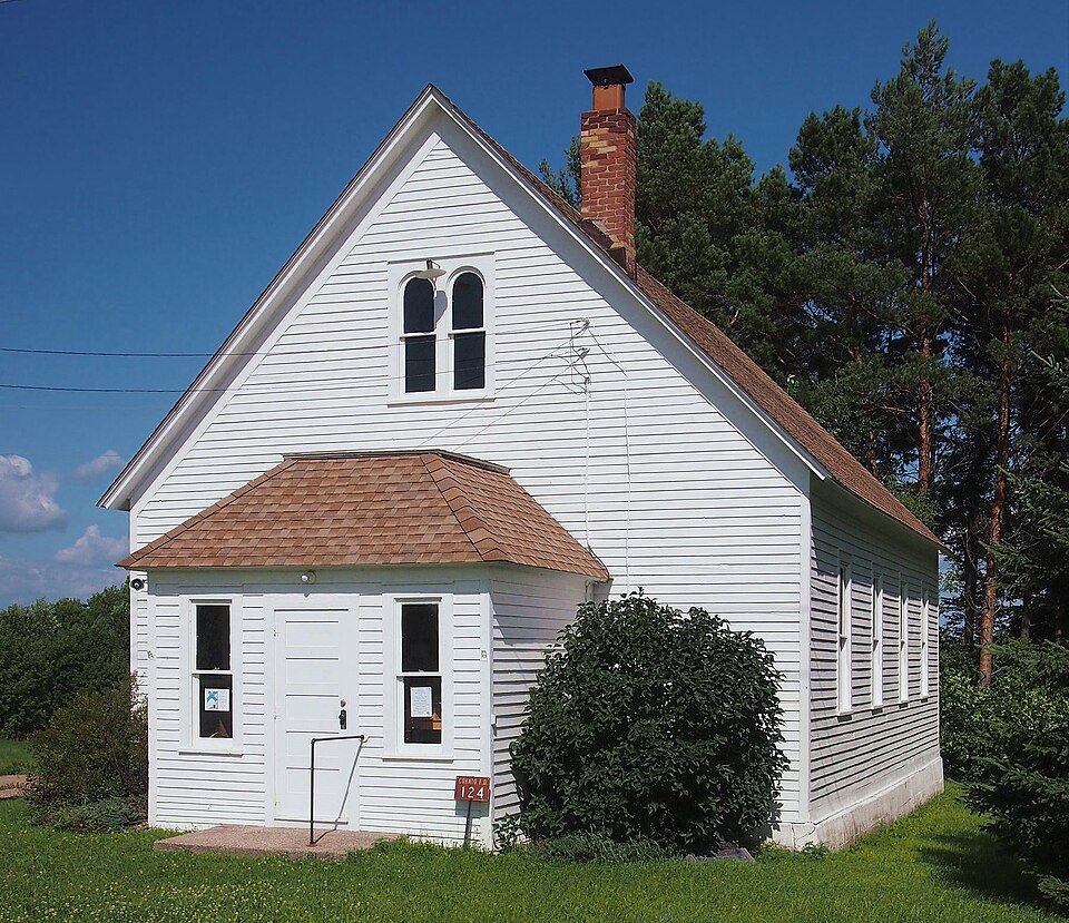
Listed on the National Register of Historic Places in 1976.
From the record
“The Cokato Temperance Hall is a historic clubhouse built in 1896 in Cokato Township, Minnesota, United States, to serve as an alcohol-free social center in a rural Finnish American community. It was constructed by a local temperance society at a rural crossroads which became known as Temperance Corner.”
Wikipedia article Cokato Temperance Hall, CC BY-SA 4.0.
One of 22 National Register listings published here for Wright County · listed in 1976 · category: Building.
National Register reference number.76001081- the number the National Park Service assigned this property when it was listed, and the key its nomination file is catalogued under at the National Archives.
Cokato embraces Congressional township 119, range 28. It is bounded on the north by the township of French Lake, on the east by Middleville, on the south by Stockholm, and on the west by Meeker county. The north fork of the Crow river passes through sections 2, 11 and 12, in the northeast part of the town. Sucker ereek flows from the south part of the town nearly through Cokato lake, in sections 14, 15 and 23. This is the largest lake in
The first actual settlers were Josiah P. Mooers and his sons, Augustus P. and Henry. They came to Minnesota from Maine in 1852, and in August, 1856, settled on section 34 in what is now Cokato township. All three became prominent men. Among other early settlers were Joseph Lane, Samuel Pavitt, Amos Chambers, Daniel Rose, William Lee, Luman Putnam, Timothy Lowell, David Griffith and Hugh MeNulty. Lane came in 1856; Griffith, Lee and Putnam in 1857; Pavitt, Chambers and Rose came in 1858.
Regional context, not property-specific
evidence. The federal mineral resources record lists
1 working within 5 miles of Cokaton P.R.S. Onnen Tovio Raittiusseura: 1 past producer.
None of them still produces. What was taken out: Sand and Gravel, Construction. Distance is straight-line from the
map coordinates, so a quarry counted here may appear on a neighbouring
settlement's page as well.
Regional context, not property-specific
evidence. The National Weather Service names
Cokato, the town this property stands in, in 52 storm reports between 1997 and 2025: 29 hail, 21 thunderstorm wind, 2 funnel cloud.
No death or injury is recorded in these reports. Each account below is quoted exactly as the forecast office
filed it, from the NOAA Storm Events Database, and each date
opens the federal record of that event.
In addition to the quarter size hail, a wind gust of 55 mph southwest of of Cokato. There was a social media video of power poles blown down and large hail covering the ground.
Residence affected was at 25495 750th SW. Just to the Southwest of the residence several trees in a small wooded area were toppled. In the Southwest portion of the farm site there was a tin shed approximately 20 feet by 40 feet. The majority of the tin shed roof was blown off or caved into the structure. Shingles blown off portion of roof of home on this property. Antenna on roof also damaged. Power lost for several hours. Portion of barn also damaged, with small sections of board from barn burrowed into the ground. Some wind damage to corn crop on Eastern portion of residence.
Damage occurred at 72780 240th St. Damage included: a small canvas shed blown down. Two trees severed at the base of the trunk, several tree branches also severed. A pole holding up a small television antenna was blown over.
Roof damage. Semitrailer blown over. Church steeple blown over. Township hall sustained heavy damage including roof blown off and wall collapse. Estimated windspeed.
No historic map-sheet match is published
for this property yet. That does not mean no map exists. This record needs
a coordinate-quality review before it can be joined to a sheet boundary.
Browse the county's mapped places while that work is
pending.
Listed places nearby
2 within 8 miles
Other National Register properties close
enough to walk or drive between, ordered by distance from this one. Both
positions come from the same geocoding pass that matched these properties
to their map sheets.
Listing record. National Park Service National Register of Historic Places, listed-properties dataset, current to 2026-05-22.
Map join. Address geocoded through the United States Census geocoder, then tested against the published boundary of every sheet in the USGS Historical Topographic Map Collection.
How this page is made. Listing fields come from federal records; map-sheet coverage is a labelled coordinate-to-boundary calculation, not a source-field claim.
Mines and quarries. USGS Mineral Resources Data System (MRDS) https://mrdata.usgs.gov/mrds/ A work of the United States government, no copyright under 17 U.S.C. 105.
Storms. NOAA National Centers for Environmental Information, Storm Events Database https://www.ncei.noaa.gov/stormevents/ A work of the United States government, no copyright under 17 U.S.C. 105. Narratives are quoted verbatim from the National Weather Service report and are not edited or summarised.
 Block