BlockBefore
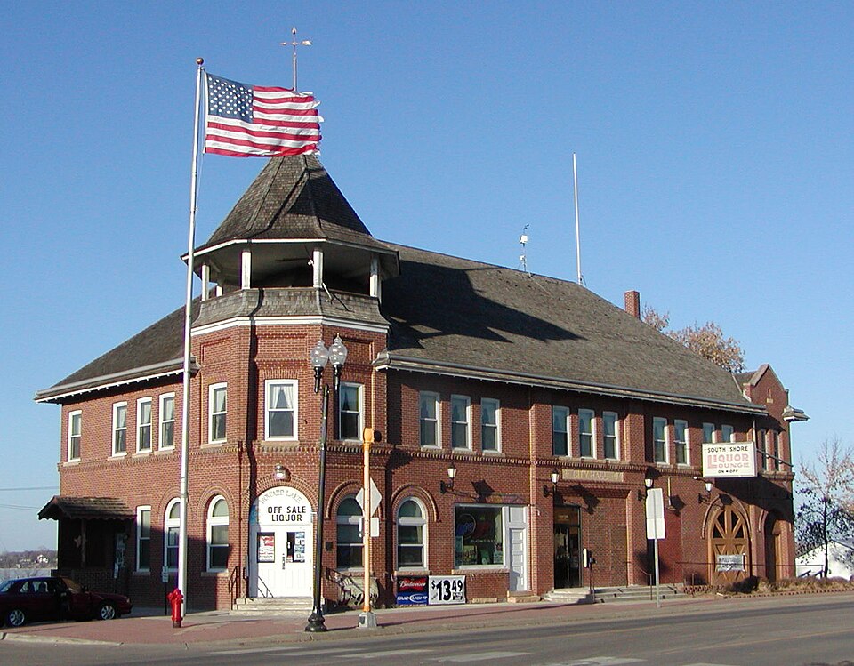
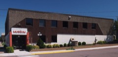
Photograph of Howard Lake City Hall
Photograph by William Wesen Appraiser, CC BY-SA 3.0. Via Wikimedia Commons.

Howard Lake City Hall

Listed on the National Register of Historic Places in 1979.

From the record

“The historic Howard Lake City Hall is a multipurpose government building in Howard Lake, Minnesota, United States, built in 1904. It originally housed the city's government offices, post office, public library, fire department, and public meeting hall.”

Wikipedia article Howard Lake City Hall, CC BY-SA 4.0.

One of 22 National Register listings published here for Wright County · listed in 1979 · category: Building.

Sources: the Wikipedia article · the case file at the National Archives · the National Register database, National Park Service

The listing

  • What is counted as historic. The nomination lists 1 building as contributing to the listing.
  • Address. 737, 739 and 741 6th St., Howard Lake, 55349
  • When was it listed? December 1979
  • Category. building
  • Also known as. Wright County MRA
  • City. Howard Lake city
  • Architectural style. Queen Anne style
  • National Register reference number. 79001269 - the number the National Park Service assigned this property when it was listed, and the key its nomination file is catalogued under at the National Archives.

The ground it stands on

1,001 words

The chapter on Howard Lake City in History of Wright County, Minnesota Volume II, published 1915 names Howard Lake. This is what it says, exactly as the scans read.

Albert G. Moffatt, M. D., a skilled and scholarly physician and surgeon of Howard Lake, was born in the Province of Ontario, Canada, September 5, 1865, son of James and Caroline (Pratt) Moffatt, who brought their family from Canada and settled in Pembina county, North Dakota, in 1883. Albert G. Moffatt received his preliminary education in the common schools, and in 1892 entered the medical department of the University of Minnesota. He graduated with the class of 1895, and at once opened an office in Howard Lake. In 1907 he took a post graduate course in the Cook County Hospital, Chicago, Ill. Dr, Mof. fatt's practice has been successful from the start. With technical mastery he combines a wide sympathy and understanding, and his name is held in the highest regard and affection in the hundreds of homes where he has ministered. His reputation, however, has not been confined to Howard Lake and vicinity. For several years he has sat as one of the Homeopathic members of the State Board of Medical Examiners, In the Minnesota State Homeopathic Society he has been vice president, director, and chairman of several important bureaus. Locally he has been president of the village council, influential member of the school heard, and president of the Howard Lake Commercial Club. For a number of years has done good service as coroner of Wright county, a position he still retains. A recent publication has said:

Passage source: History of Wright County, Minnesota Volume II, published 1915.

Dr. Moffatt married Alice Hoffman, of Canada, the daughter of John and Jeanette (Frazier) Hoffman, of Irish-German blood. Mrs. Alice (Hoffman) Moffatt died in 1889 at the age of twentyfour, leaving two children, Eva Thankful, wife of W. T. Campbell, of Golden Valley, N. D., and Janie Alberta, a graduate nurse, now living in Napa, Calif. Later, Dr. Moffatt married Alice J. Dillon, born in the province of Ontario, daughter of Robert and Alice (Hutchinson) Dillon, who spent the span of their years in Canada. Dr. Moffatt, by this marriage, has two children, Albert G., Jr, and Ralph. Albert G., Jr, is a graduate of the Howard Lake High school. Mrs. Moffatt is a member of the Library Club.

Passage source: History of Wright County, Minnesota Volume II, published 1915.

Machine-read from a century-old scan, so expect the errors a machine makes: misspelled names, dropped words, stray characters.

Read the whole chapter on Howard Lake City - 1,001 words on its settlement, mills, schools and churches.

Fires near this property

1 since 2011

Regional context, not property-specific evidence. The federal wildfire occurrence database lists 1 fire within 5 miles of Howard Lake City Hall in 2011, burning about 3 acres in total. None started naturally. None was recorded as arson. Distance is straight-line from the map coordinates, so a fire counted here may appear on a neighbouring settlement's page as well.

Reported cause Fires
Missing data/not specified/undetermined1

The most recent of them, most recent first, with the day each was reported and the service that recorded it.

DateCause SizeReported by Name on the report
9 November 2011Missing data/not specified/undetermined3.0 acresMinnesota Department of Natural Resourcesnot named

Every fire recorded in Wright County

Storms near this property

43 since 1993

Regional context, not property-specific evidence. The National Weather Service names Howard Lake, the town this property stands in, in 43 storm reports between 1993 and 2025: 23 thunderstorm wind, 14 hail, 3 tornado, 2 funnel cloud. No death or injury is recorded in these reports. Each account below is quoted exactly as the forecast office filed it, from the NOAA Storm Events Database, and each date opens the federal record of that event.

WhenEvent Place namedHarm What the report says
September 2019Tornado (EF1)Howard Lake$250,000A brief tornado occurred just southwest of Howard Lake, MN. The tornado damaged 3 properties, with 2 barns heavily damaged and a private residence with shingles ripped off along with numerous trees snapped along the path of the tornado.
June 2016HailHoward Lake$10,000A large swath of hail occurred in southern Wright County between Howard Lake and Watertown. The largest hail stone was measured at 2.5 inches (tennis ball) between Montrose and Watertown along Highway 25.
May 2025Thunderstorm WindHoward Lake-Three large trees were downed.
July 2025Thunderstorm WindHoward Lake-Trees down in both Cokato and Howard Lake.
June 2023Thunderstorm WindHoward Lake-Local law enforcement and trained spotters reported numerous trees and power lines down in the city of Howard Lake, MN, but no reported injuries or fatalities. A mesonet station just northeast of Lake Mary (5 miles south-southwest of Waverly) measured 68 mph. Also 4 miles SSW of Waverly, MN, a trained spotter reported damage to an agricultural field where crops appeared to have suffered wind and hail damage. Strong winds caused major damage to multiple barns on a farmstead. The strong thunderstorm continued into far northeastern McLeod County.
May 2022Thunderstorm WindHoward Lake-Several trees were blown down around Howard Lake.
July 2016Heavy RainHoward Lake-A trained spotter measured 4.00 inches of rain near Howard Lake.
July 2015Thunderstorm WindHoward Lake-Three large trees blown down, with some crop damage on County Road 30 near Howard Lake.
August 2011Thunderstorm WindHoward Lake-A large tree blew down and blocked County Road 5 near Howard Lake.
August 2010Thunderstorm WindHoward Lake-Several large tree branches were blown down near Howard Lake, Minnesota.
August 2007Thunderstorm WindHoward Lake-Very large tree toppled over a roadway.
June 2007HailHoward Lake-Occurred on the North side of town near Highway 12.
June 2007HailHoward Lake-On Highway 12 between Waverly and Howard Lake.
July 2006Thunderstorm WindHoward Lake-Trees and power lines down.
September 2006Thunderstorm WindHoward Lake-Trees downed.
June 2005Thunderstorm WindHoward Lake-Trees were downed onto power lines 4 miles north of Winsted.
September 2005HailHoward Lake-Nickel sized hail was reported by a trained spotter near Highway 12.
April 2004HailHoward Lake-Penny sized hail fell just north of Winsted.
June 2002Thunderstorm WindHoward Lake-Tree blown onto shed.
June 2002Thunderstorm WindHoward Lake-Few trees down and power lines down.
June 2002Thunderstorm WindHoward Lake-Tree down across road.
June 2002Thunderstorm WindHoward Lake-Trees down, including one on shed.
June 2002Thunderstorm WindHoward Lake-Large tree down in road.
September 1998Thunderstorm WindHoward Lake-Trees and power lines down. Estimated windspeed.
May 1998Thunderstorm WindHoward Lake-Trees blown over. Estimated windspeed.
May 1998Thunderstorm WindHoward Lake-Trees and power lines down. Estimated windspeed.
July 1997Thunderstorm WindHoward Lake-Tree blown onto house. Estimated windspeed.
July 1997Tornado (F3)Howard Lake-House completely destroyed on west side of Birch Lake.
July 1995Tornado (F1)Howard Lake-This affected mainly open country. On ground for six to 12 minutes. Metal shed destroyed. The width was estimated. Lifted off ground one mile northwest of Waverly.
June 2025HailHoward Lake-no account filed
September 2019Thunderstorm WindHoward Lake-no account filed
July 2008HailHoward Lake-no account filed
June 2007Funnel CloudHoward Lake-no account filed
June 2007HailHoward Lake-no account filed
May 2006HailHoward Lake-no account filed
May 2004HailHoward Lake-no account filed
April 2002HailHoward Lake-no account filed
June 2002HailHoward Lake-no account filed
May 1998Thunderstorm WindHoward Lake-no account filed
May 1996Funnel CloudHoward Lake-no account filed
August 1993Thunderstorm WindHoward Lake-no account filed

Every storm recorded in Wright County

Map coverage status

No historic map-sheet match is published for this property yet. That does not mean no map exists. This record needs a coordinate-quality review before it can be joined to a sheet boundary. Browse the county's mapped places while that work is pending.

Listed places nearby

5 within 8 miles

Other National Register properties close enough to walk or drive between, ordered by distance from this one. Both positions come from the same geocoding pass that matched these properties to their map sheets.

Sources for this property

National Archives recordThe nomination case file for reference 79001269 in Record Group 79.
Wikipedia articleCommunity-written account of this property, licensed CC BY-SA.
Wright CountyAll 22 listed properties in this county.

Provenance

  • Listing record. National Park Service National Register of Historic Places, listed-properties dataset, current to 2026-05-22.
  • Map join. Address geocoded through the United States Census geocoder, then tested against the published boundary of every sheet in the USGS Historical Topographic Map Collection.
  • How this page is made. Listing fields come from federal records; map-sheet coverage is a labelled coordinate-to-boundary calculation, not a source-field claim.
  • Wildfire. Short, Karen C. 2022. Spatial wildfire occurrence data for the United States, 1992-2020 [FPA_FOD_20221014]. 6th Edition. Fort Collins, CO: Forest Service Research Data Archive. https://doi.org/10.2737/RDS-2013-0009.6 Collected with United States Government funding and usable without additional permissions or fees.
  • Storms. NOAA National Centers for Environmental Information, Storm Events Database https://www.ncei.noaa.gov/stormevents/ A work of the United States government, no copyright under 17 U.S.C. 105. Narratives are quoted verbatim from the National Weather Service report and are not edited or summarised.